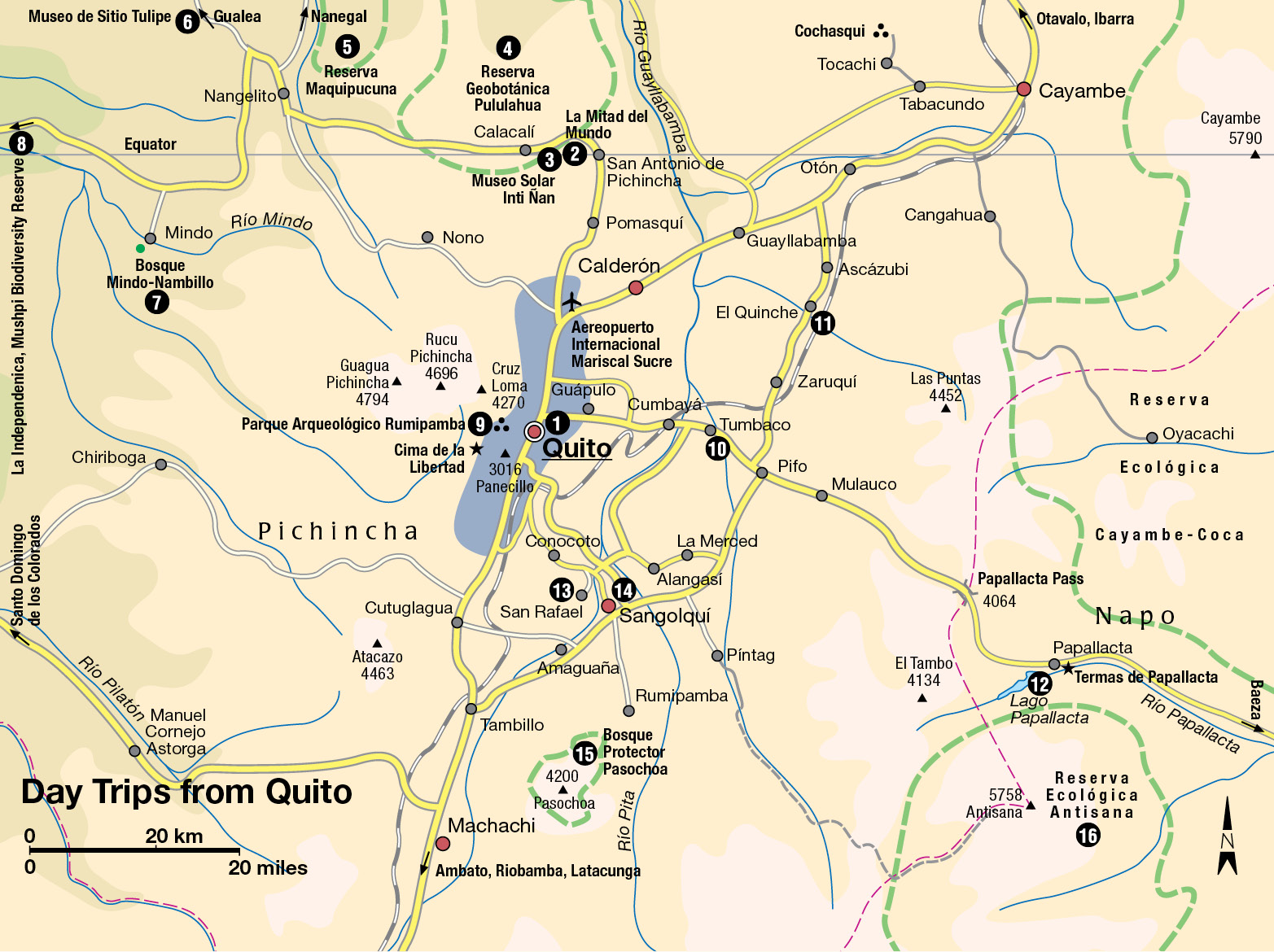
There are many day-long excursions from Quito 1 [map] into the surrounding Andean Sierra. By renting a car, taking a tour, or using public transportation or taxis, you can discover a region crowded with mountains, waterfalls, thermal baths, and peaceful villages.
Buses to the Equatorial Line Monument, La Mitad del Mundo 2 [map], run about every half-hour on Avenida América, near the junction with Avenida Colón in the New Town. The monument is about a half-hour trip (22km/14 miles) to the north of Quito, located on latitude 0°, and provides an irresistible opportunity to straddle both hemispheres. It is a very popular spot, particularly at the equinoxes (March 21 and September 21), when the sun is directly overhead and neither monument nor visitors cast a shadow. The monument forms the focal point of a park and leisure area with gift shops and restaurants, and there is a good museum inside (Mon–Thur 9am–6pm, Fri–Sun 9am–7pm). An elevator leads to the top for fine views. Close by is the quirky Museo Solar Inti Ñan 3 [map] (tel: 02-239 5122; daily 9.30am–5.30pm), which claims to mark the true spot of the equator as measured by GPS. Fun, interactive exhibits include demonstrations of how water drains in different directions on either side of the Equator, as well as sun clocks, ethnographic displays, and best of all, some incredible 150-year-old shrunken heads: ask the administration to show you if they are not on display.
About 4km (2 miles) farther on, toward the village of Calacalí, is the Reserva Geobotánica Pululahua 4 [map], centered on what is reputedly the biggest volcanic crater in South America. A rough path leads down from the rim, and the interior of the crater has its own microclimate, with rich vegetation and diverse birdlife. Nearby is the excellent El Crater restaurant and art gallery, with fantastic views. Also to the north of Quito is the Reserva Maquipucuna 5 [map] (contact the Quito office at Baquerizo 238 and Tamayo; tel: 02-250 7200; www.maqui.org): take the coast road through Calacalí to Nanegalito (61km/38 miles) and at the village follow the signposts for 19km (12 miles). The reserve consists of steeply sloping cloud forest, with a great diversity of fauna and flora.
Farther along the Calacalí–La Independencia road is the recently opened Museo de Sitio Tulipe 6 [map] (Tulipe Archeological Site Museum; tel: 02-285 0635; Wed–Sun 9am–4pm), which is situated between Nangelito and Gualea. The site has some 2,000 pyramids and mounds, constructed by the pre-Inca Yumbo people who inhabited the valleys north of Quito c.AD 800–1660. The ruins are thought to have been the Yumbo’s main ceremonial site, with water being of great importance to rituals here, as shown by the remains of several channels and pools.
Further west, the Bosque Mindo-Nambillo 7 [map], near Mindo, is a protected reserve that is home to birds, orchids, and bromeliads. The 20,000-hectare (49,400-acre) forest covers land of varying altitudes, which makes for a very diverse ecosystem, supporting some 325 species of bird. Tour operators in Quito offer all sorts of day excursions and longer trips to the forest, and there are several good lodges here which make Mindo a popular break from the city for nature-spotting and relaxation.
A further 60km (37 miles) on again along this road is the turning for the Mashpi Biodiversity Reserve 8 [map], a pocket of privately-owned cloud forest 2.5 hours’ drive from Quito where you will find Ecuador’s best ecolodge, Mashpi Lodge. There are phenomenal birdwatching opportunities here but the reserve is only for the use of guests of Mashpi Lodge.
Back closer to Quito, the Parque Arqueológico Rumibamba 9 [map] (Wed–Sun 8am–4.30pm) is making a stir. Located on the western edge of the city, the site was uncovered by excavators preparing to build a new housing project. The digging revealed Inca walls and thousands of artifacts from the Yumbo civilization. It is now all protected in this 32-hectare (79-acre) site, with an excellent museum in a restored hacienda as its centerpiece.
On the opposite side of Quito, the city’s eastern fringes, lies the tiny village of Guápulo with its 400-year-old church containing works by the country’s best-known 17th-century artists: this was the founding spot of the School of Quito. This church and former convent has a pulpit carved by indigenous sculptor Juan Menacho that is unquestionably the loveliest in Quito. From here, you pass through the district of Cumbayá, into the valley of Los Chillos, and through the countryside along the winding Río San Pedro. The settlement of Tumbaco ) [map] is a green oasis close to the city and has many weekend houses and good restaurants, as well as a famous bungee-jump from the bridge at Chice.
Miracles and hot springs
The road through the Tumbaco valley passes through the sanctuary of El Quinche ! [map], which attracts pilgrims from all over the northern Sierra. The Virgin of El Quinche is renowned for her miracles, and is a favorite among drivers and transport workers. Many make the yearly pilgrimage to Oyacachi, where the Virgin Mary statue originated. This small isolated community has some hot springs set in a lush valley at 3,200 meters (10,500ft) in the Cayambe Coca Reserve, just beneath the páramo (high-altitude plateau). It is connected to Cayambe and Quito via Cangahua.
Descend the main road (unpaved but well maintained) from El Quinche to the south. The view is wonderful, and snow and subtropical forests lie close together. At Km 59, the small Lago Papallacta @ [map] is renowned for trout fishing. At Km 60, a road branches off to the springs of Huanonumpa, commonly known as the thermal springs of Papallacta and the most attractively developed hot springs in Ecuador. Stay overnight in the comfortable Termas de Papallacta hotel and go for a dip in one of its private pools. The public pools by the restaurant are crowded on weekends.
The Valle de los Chillos, another area of thermal springs, lies some 30 minutes’ drive east of Quito. There is a fine descent into the valley on the Via Oriental and the Autopista de Los Chillos. The highway crosses the valley’s main road in San Rafael £ [map] (12km/8 miles). Stop here to visit La Casa de Kingman Museo (tel: 02-86 1065; Thur–Fri 10am–4pm, Sat–Sun 10am–5pm), the former home of the artist Eduardo Kingman. It now displays his works alongside other notable colonial and modern art. Ahead lies the village of Sangolquí $ [map], known for its Sunday market. Nearby, at La Merced and El Tingo, are some more thermal springs (turn left at San Rafael).
To the south of Sangolquí is the village of Amaguaña, which can be reached by bus from Quito (about an hour’s drive). A few kilometers from Amaguaña, set around an extinct volcano, is the Bosque Protector Pasochoa % [map], a sanctuary for birds and native plants (orchids bloom from February to May). For excursions, contact Fundación Natura. The road to Volcán Antisana goes through Pintag. The volcano, which is protected in the Reserva Ecológica Antisana ^ [map], has four snowy peaks, which are very difficult to climb. To use the road you must get the permission of the Fundación Antisana in Quito (Gonzalo Serrano E 10–27 and Av. 6 de Diciembre; tel: 02-243 0861). In the surrounding reserve condors, rainbow ducks, and other birds can be seen.