Most travelers to the Galápagos arrive by air, except for a few who have pre-arranged trips on one of the larger cruisers that occasionally depart from Guayaquil. Flights from Quito connect through Guaya-quil. TAME flies daily to the island of Baltra, from where a bus and ferry will take you across to Puerto Ayora on Santa Cruz, and three times a week to San Cristóbal. Aerogal offers thrice-weekly flights to San Cristóbal and Baltra. On arrival, you must have your passport ready and $100 entrance tax to the Galápagos; without these two essentials, you will not be able to enter the islands.
Many travelers will have pre-arranged their cruise around the islands on one of the larger luxury ships. Two of the best on offer are the Galápagos Explorer II, a liner operated by Canodros, which leaves from Baltra; and the Santa Cruz, run by Metropolitan Touring, which leaves from San Cristóbal. Both offer all the comforts of a five-star hotel, with excellent food, swimming pools, evening slide shows, and the like. They also have English-speaking guides who are all qualified naturalists. Although the capacity of these ships is 90 people, they operate with groups of no more than 20, landing them by small dinghies called pangas for twice-daily excursions. The large boats have the advantage of covering a lot of territory by night, easily reaching the more remote islands without unduly rough passages. Smaller luxury boats carrying 16–20 passengers, such as the Beluga run by Enchanted Expeditions, offer a more intimate experience.
Fact
A handful of European settlers arrived on the islands before the 1960s. The -Wittmer family from Cologne, Germany, settled on remote Floreana in 1932, whose descendants still run the only hotel on the island. The autobiography of Margret Wittmer, who died in 2000, describes the mysterious affair involving the family and other German-speaking immigrants that lead to three unresolved deaths and two -disappearances.
Independent and budget travelers may organize their own cruise on one of the dozens of smaller boats on the islands. This can be arranged in Quito or Guayaquil, but is cheapest when done in Puerto Ayora on Santa Cruz, though a few small boats also operate from San Cristóbal. Take your time, meet up with other like-minded travelers, find a captain, and agree a price. This usually takes two or three days, but if you have more time than money it’s worth doing. The main advantage of organizing your own trip is flexibility: you can choose which islands you want to visit, for how long, and when. However, the guides often do not speak English, and rough weather conditions can make night journeys on these boats difficult for those with delicate stomachs. For younger, independent travelers, this is an experience not to miss.

A typical Galápagos coast scene with marine iguana, black volcanic rocks, prickly pear cactus, and emerald sea.
Maudem/Dreamstime.com
A guide to the visitor sites
The only places where boats may land on the islands are at the 56 designated visitor sites, and even then visitors must be accompanied by a guide. Some of the more fragile sites are further restricted so that only small groups are allowed to visit, or limits are imposed on the numbers each month. The landing by panga is either wet or dry; your guide will tell you which to expect. Wet landings simply mean that you leap into the water up to your ankles (sometimes up to your knees), so keep your shoes aside; dry landings are at natural or manmade jetties, where you should keep your shoes on.
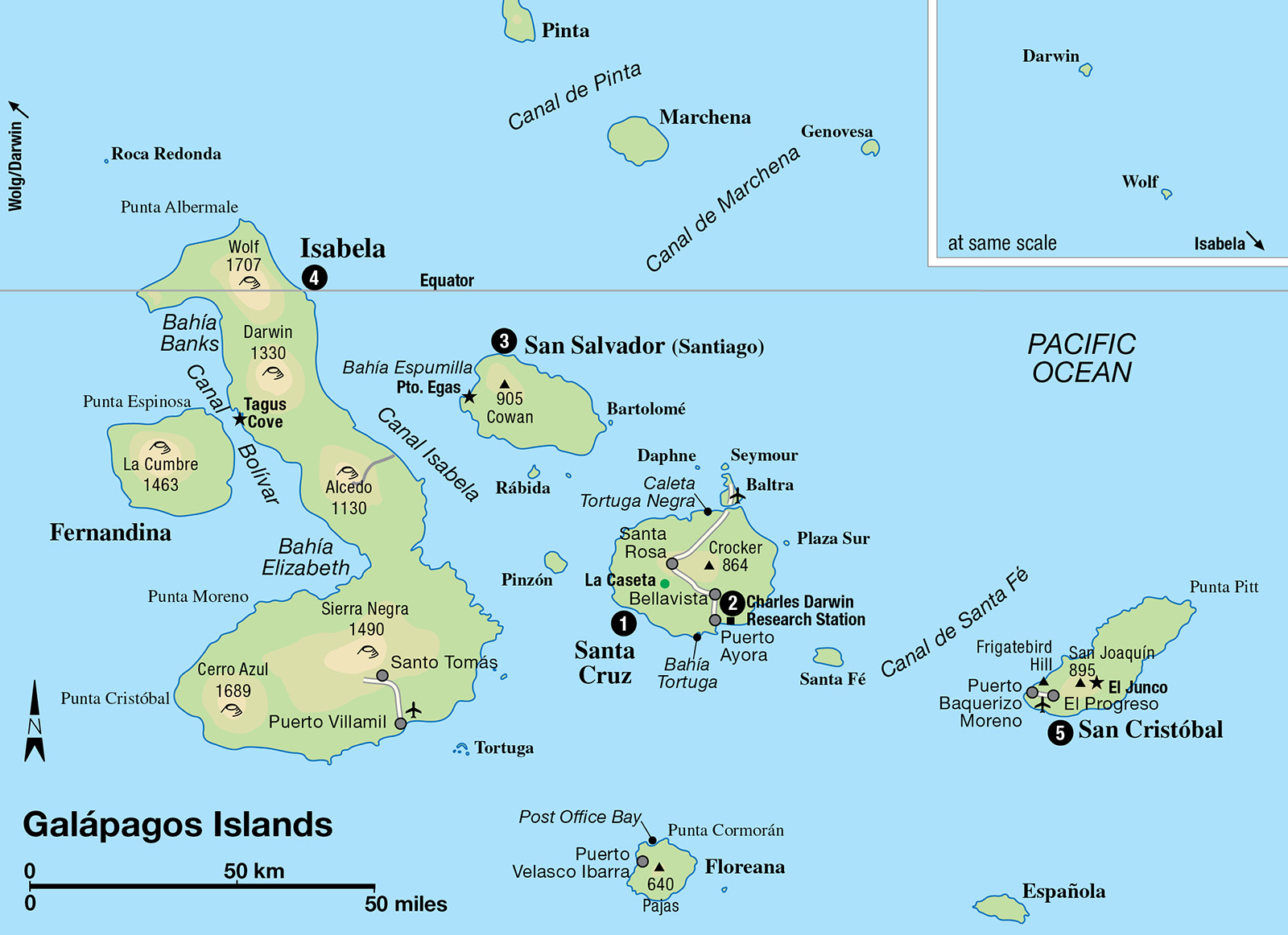
The most densely populated island in the Galápagos, as well as its second-largest (at 986 sq km/380 sq miles), is Santa Cruz 1 [map]. Most tours start here at the township of Puerto Ayora, and even those that begin at San Cristóbal call here to visit the Charles Darwin Research Station 2 [map].
Tip
While last-minute booking is possible in Puerto Ayora, visitors are unlikely to succeed in securing berths on ships during the July and August holiday months as well as around Christmas and New Year. Beyond hiking, snorkeling, and diving, other sports on the islands include biking, kayaking, surfing, and windsurfing. Active tours can be booked at tour operator Lonesome George in Puerto Ayora (Av Opuntia and Av Padre Julio Herrera; tel: 05-252 6245).
Puerto Ayora has grown in size and population in recent years. The wide, turquoise Academy Bay is full of small boats and makes a picturesque sight, while the town docks are usually crowded with small children running, swimming, and playing with sea lions. Ayora has plenty of small hotels and restaurants, the most eccentric being the Sol y Mar. It sits right on the waterline and its porch is always crowded with marine iguanas (they may walk over your feet while you are having breakfast, which can be something of a surprise until you get used to it).
The main attraction is the research station. This is the classic place to have your photo taken with one of the giant tortoises: mature specimens of several subspecies are kept in pens here. While you often see pictures of tourists riding tortoises, this can damage their shells and is prohibited. The station has a tortoise breeding house, where the young can be seen, and a small museum and information center.
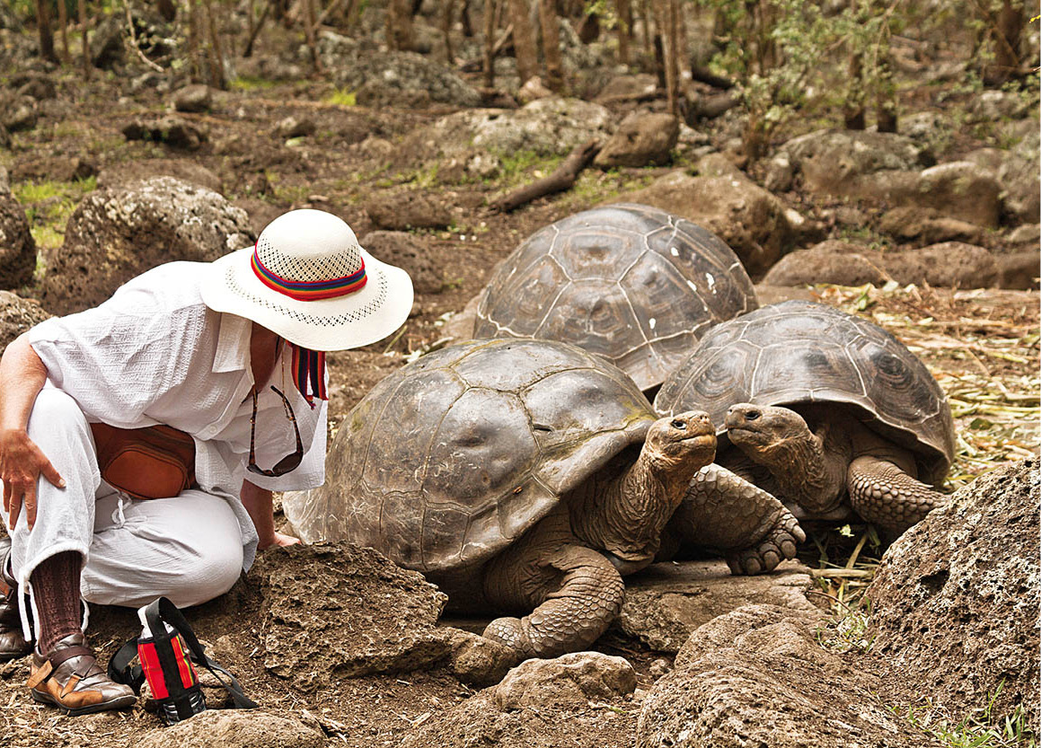
Getting close to giant tortoises.
Tag1933/Dreamstime.com
There are several trails from Puerto Ayora that are worth exploring. Some 7km (4 miles) westward is Bahía Tortuga (Turtle Bay), with fine white sand and waters rich in lobsters. You can go there to swim and relax without a guide, although the fish and animals are still protected. The highland interior of Santa Cruz, in the national park, offers several attractions: the lava tubes are long underground tunnels made when lava solidified on the surface of a flow but kept going underneath. Climbing Cerro Crocker, an 860-meter (2,800ft) high hill, shows the range of vegetation zones on the island. And a day excursion can be made to the Tortoise Reserve, which is one of the few places to see giant tortoises in the wild; organize your trip beforehand with a tour guide in the town or visit independently: you need to hire a jeep and then take a two-hour walk to see these creatures wallowing in the mud.
On the north coast of the island lies Caleta Tortuga Negra (Black Turtle Cove). This tidal lagoon leads into a maze of mangroves: it can be visited only by panga, cutting the motor and paddling quietly through the natural tunnels made by trees. The brackish waters of the area are full of white-tipped sharks and mustard rays. But it is most famous as a mating spot for the green Pacific turtles. With luck, you can spot the two heads coming up for air during copulation, which lasts for many hours.
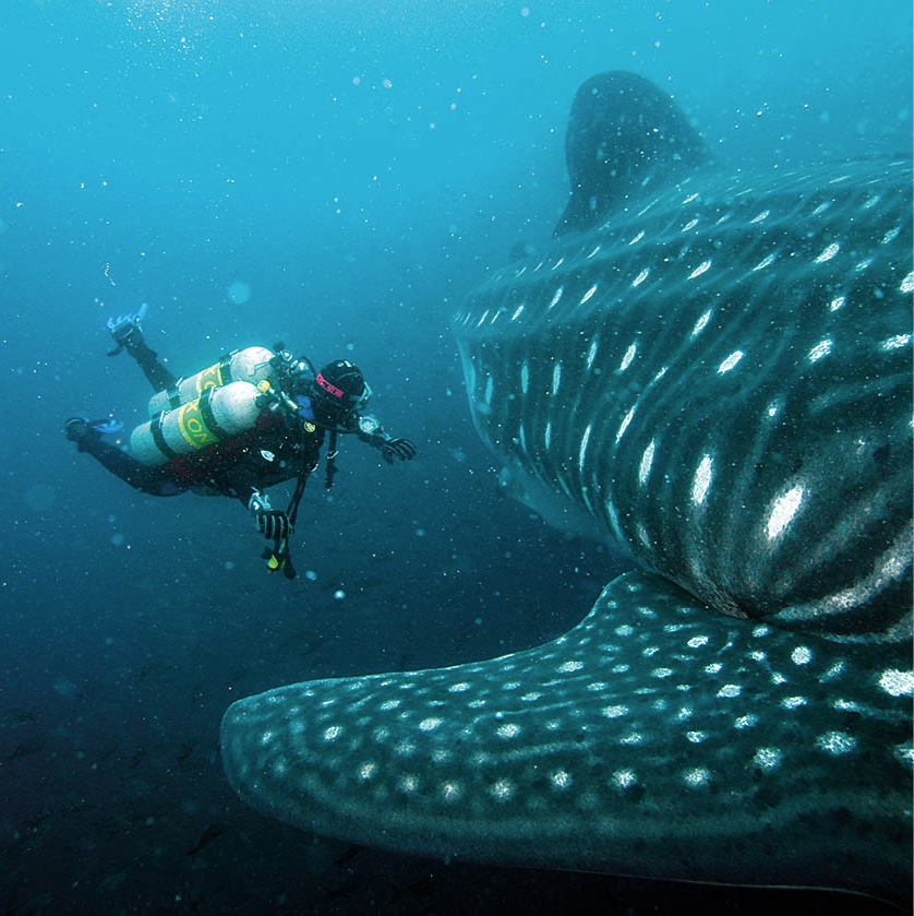
A scuba diver approaches a whale shark.
Ferdinandas/Dreamstime.com
The central islands
The islands close to Santa Cruz are the most visited, although not necessarily the most interesting for naturalists. Day trips are run by various agencies from Puerto Ayora: this means a lot of traveling time on the water if you want to visit more than one. It is more fun and – if properly organized – only slightly more expensive to visit several on your own cruise.
Only 24km (15 miles) from Puerto Ayora is Isla Santa Fe (also known as Barrington). A compulsory wet landing is the start of a short trail into a dry landscape crowded with opuntia cacti. Santa Fe is one of the best places to see the shy land iguana, but the steep path is one of the more difficult on the Galápagos, so a swim from the beach near the landing site comes as a welcome relief.
Off the northeastern coast of Santa Cruz is the tiny island of Plaza Sur. Only 13 hectares (32 acres) in area, its coast is so crowded with sea lions that everyone on the panga needs to clap and shout to clear a landing space. Swimming is not encouraged here, since the macho or bull sea lions are particularly aggressive. Plaza Sur is unusually crowded with animal life; there are plenty of land iguanas and the impressive black cliffs are populated with seabirds, as well as the rare Galápagos hawk. Nearby is a “convalescent home” for bachelor macho sea lions: after losing a brawl over territory, they come here to recuperate before returning to the fray.
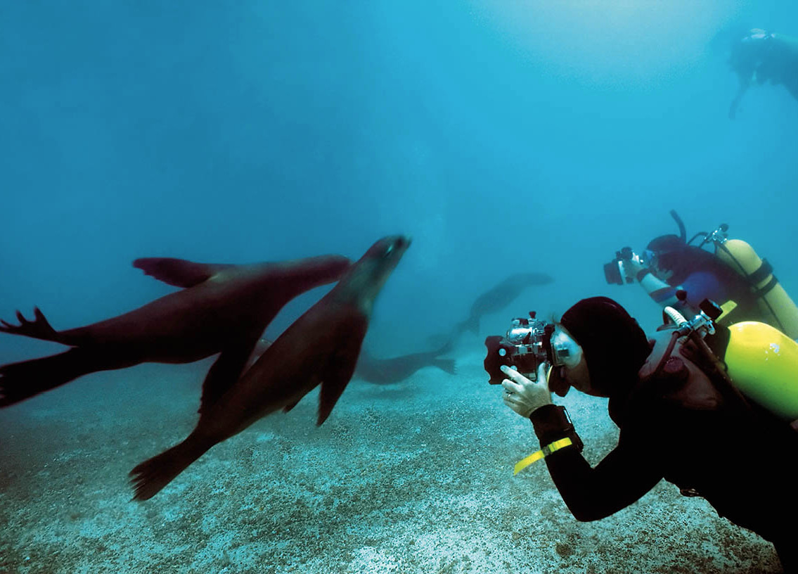
Sea lions provide an underwater photo opportunity.
Dennis Sabo/iStockphoto
Isla Seymour is separated from the larger island of Baltra by a channel. Baltra has little to interest a visitor, whereas Seymour is one of the Galápagos’ best breeding grounds for seabirds: blue-footed boobies are so common that visitors have to be careful not to step on any of the nests that may have been built on the trails.
The strange, block-shaped island of Daphne is 10km (6 miles) away. Access is restricted to only a few boats a month. Landing here is difficult, with a leap onto nearly sheer rocks that becomes somewhat hair-raising in rough weather. But it is worth the effort: at the end of a trail, a large crater is dotted with hundreds of blue-footed booby nests, making a decidedly surreal sight.
Volcanic rock and iguanas
One of the larger islands, relatively close to Santa Cruz, is known as either Santiago or James, although its official title is San Salvador 3 [map]. It has a number of landing sites, by far the most popular being Puerto Egas on the west coast. This is one of the best places to see hundreds of marine iguanas sunning themselves on black volcanic rocks, while fur seals can be spotted swimming nearby. The Sugarloaf Volcano dominates the horizon here. Swimming is good at Espumilla Beach and Buccaneer Cove. If you are in a small group, try snorkeling at the fur seals’ grotto. You can swim with these characters for hours through the pools that have formed under natural stone archways.
Sitting off the east coast of San Salvador, the small 120-hectare (300-acre) island of Bartolomé is one of the most photographed in the Galápagos. The centerpiece of a visit is the steep climb up Cerro Bartolomé: the view is spectacular, looking over lunar fields of dried lava, craters, and out over the jutting, honeycombed Pinnacle Rock. The heat is also quite intense, so after working up a sweat, transfer to the second landing site, one of the most pleasant beaches on the islands. The snorkeling is excellent, especially around Pinnacle Rock itself: apart from the tropical fish moving in formation, you have a chance of spotting teams of penguins hunting underwater. A path leads over to the other side of the island, where dozens of reef sharks patrol only meters from the edge of the water.
South of San Salvador is the island of Rábida (Jervis), which has a dark-red sand beach (due to its high iron-oxide content) along which lounge hundreds of bloated sea lions. Indolent and clumsy on land, they are surprisingly energetic in the water: this is a great place to observe the baby sea lions.
A path into the interior of the island passes a marshy lake full of bright pink flamingos (the pinker the flamingo, the healthier it is; the feather color comes from the diet of shrimps they sieve through their beaks). In the trees by the beach are a large number of brown pelicans.
When cruising the south coast of San Salvador, keep an eye out for Sombrero Chino, literally “Chinese Hat,” named for the island’s sweeping conical shape. One of the more recent islands, it has a 400-meter (1,300ft) -long path around its circumference, along which sea lions relax in abandonment.
Preserving the islands
Tourism is a mixed blessing for the Galápagos: follow these guidelines to ensure that the islands will be left unaltered by your visit.
No natural object – plant, animal, shell, bone, stone, or scrap of wood – should be removed or disturbed. It is illegal and alters the islands’ ecological conditions.
Be careful not to transport any live material to the islands, or from island to island. Before leaving the boat, check your shoe soles for dried mud, as it may contain plant seeds and animal spores. Inadvertent transport of these materials represents a special danger to the Galápagos: each island has its own unique fauna and flora, and introduced plants and animals can quickly destroy them. Obviously no other animals or plants should be brought to the islands.
For the same reason, do not take any food to the uninhabited islands. Along with the food may come insects or other organisms that might threaten the fragile island ecosystems. Fresh fruits and vegetables are especially dangerous: a dropped orange pip, for example, may become a tree.
Animals may not be touched or handled. Young animals that have been handled may be rejected by their mothers because of their smell. They soon die as a result.
Animals may not be fed. Not only can it be dangerous but in the long run it can destroy the animals’ social structure and affect their reproduction.
Do not startle or chase any animal from its resting or nesting spot. Exercise extreme caution among the breeding colonies of seabirds. These birds will fly from their nests if they are startled, often knocking the egg or chick to the ground or leaving it exposed to the sun. (A recently hatched booby chick will die in 20 to 30 minutes if it is exposed to the sun; frigate birds will also eat any unguarded chick.)
Do not leave the designated visiting sites. Where trails to points of interest are marked with wooden stakes, you should remain within the stakes.
Litter of all types must be kept off the islands. Disposal at sea must be limited to certain types of garbage which can be thrown overboard in selected areas. Keep all rubbish in a bag or pocket, to be disposed of on your boat. The crew of your vessel is responsible to the national park for proper trash disposal. Never throw anything overboard.
Do not buy souvenirs or objects made from plants or animals. Black coral is now endangered by islanders’ carvings. If anyone offers you any of these souvenirs, please advise the national park. Camping anywhere within the Galápagos without a permit is against the law. Contact any of the national park offices to get a permit for one of the designated sites.
All groups visiting the national park must be accompanied by an approved, qualified guide. The visitor must follow the guide’s instructions, while the guide must ensure compliance with the national park regulations.
Notify the national park service if you see any serious damage being done. You may be a decisive factor in the preservation of the islands. The head office is a 10-minute walk east of the main town of Puerto Ayora (tel: 05-252 6189; Mon–Fri 7am–12.15pm and 1.45–4.30pm), but there are also offices on San Cristóbal (Puerto Baquerizo Moreno; tel: 05-252 0497), Floreana (Puerto Velasco Ibarra; tel: 05-252 4869), and Isabela (Puerto Villamil; tel: 05-252 9178). Also use the very good Galapagos national park website for planning an environmentally-conscious trip (www.galapagospark.org).
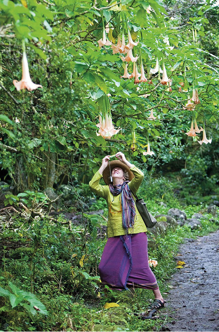
Photographing moonflowers.
John Warburton-Lee Photography/Alamy
The western islands
Some 120km (75 miles) in length and shaped like a seahorse, Isabela 4 [map]is the largest of the Galápagos Islands. It is still recovering from fires that blazed across the island in 1994. The fires were eventually extinguished, but not without a severe impact on vegetation. One of the island’s main attractions, the giant tortoises, were rescued by helicopter and taken to the other side of the island to the safety of a breeding center. Isabela is one of the islands that still has volcanic activity, and there are five cones still visible: Wolf at 1,707 meters (5,600ft); Alcedo at 1,130 (3,707); Sierra Negra (also called Santo Tomás) at 1,490 (4,888); Cerro Azul at 1,689 (5,541), and Darwin at 1,330 (4,364).
Some 3,000 people live on Isabela, mostly in and around Puerto Villamil on the south coast. Cruise ships rarely visit since it is difficult to enter the bay, especially when the sea is rough. It does, however, have a fine sandy beach and several basic hotels and restaurants. About 18km (11 miles) away is the village of Santo Tomás and the “Wall of Tears,” built of lava stone in the convict colony that was closed in 1959. The crater Santo Tomás has a diameter of 10km (6 miles), making it the second-largest in the world, while Alcedo has a still-steaming fumarole and scores of giant tortoises living at its rim.
Most of the visitor sites on Isabela are on the west side of the island. Probably the most popular is Tagus Cove. Here you can climb up a path to see the lava fields. A panga ride along the cliffs reveals colonies of penguins and other seabirds. It is probably also the best place to see the unique, but difficult to sight, flightless cormorant. Other landings can be made at Urbina Bay, Elizabeth Bay, and Punta Moreno.
On the other side of Isabela is Fernandina, one of the least visited islands because it is so remote; the island is the most westerly in the Galápagos. It has one visitor site at Punta Espinosa, with some impressive lava flows (this was probably the most recently formed major island, and still has some volcanic activity). Along its shores are more penguins and hordes of marine iguanas.

The Floreana “post office”.
John Warburton-Lee Photography/Alamy
Isla Floreana
Of historical interest on Isla Floreana, to the south of the archipelago, is the post box at Post Office Bay, where whalers used to leave mail in the late 18th century. Having been replaced several times, the box is still in use. It is the custom to look through the mail and take anything addressed to your home country, putting a local stamp on it when you arrive there and sending it on its way.
Of the visitor sites on Isla Floreana, Punta Cormorán is a sandy beach with a greenish tinge from the tiny crystals of olivine, a mineral silicate. From here a trail leads to a lagoon, where occasionally pink flamingos nest. Nearby is a second beach called Stingray, which has glistening white sands. The Devil’s Crown is a sunken crater that forms a semicircle of rocks: this is perhaps the best site for diving in the whole archipelago. Apart from the schools of brilliant tropical fish, you will probably be joined by some baby sea lions that will race snorkelers through a natural underwater archway.
Diving
Not to be outdone by the unique life above ground, the Galápagos Islands are one of the world’s premier diving areas. At 133,000 sq km (51,350 sq miles), it’s the biggest marine preserve in Latin America. Some 300 species of fish have been catalogued. Diving tours on yachts are the best way to reach remote diving spots such as Darwin and Wolf islands at the northwest end of the archipelago; both are excellent locations to see schools of endemic Galápagos, white-tipped, or black-tipped sharks, hammerheads, and even gigantic whale sharks. These, the largest species of fish in the world, can be seen June through December. Manta rays are common off Cabo Marshall on Isabela. High quantities of nutrients in the water, however, can limit under-water visibility.
The outlying islands
The most southerly island in the Galápagos is Española (Hood). Española is famous for its seabirds, particularly the waved albatross. Twelve thousand pairs nest here, the world’s entire population. During the mating season, they begin “fencing” by knocking their beaks together and waddling about “like drunken sailors,” as one observer put it.
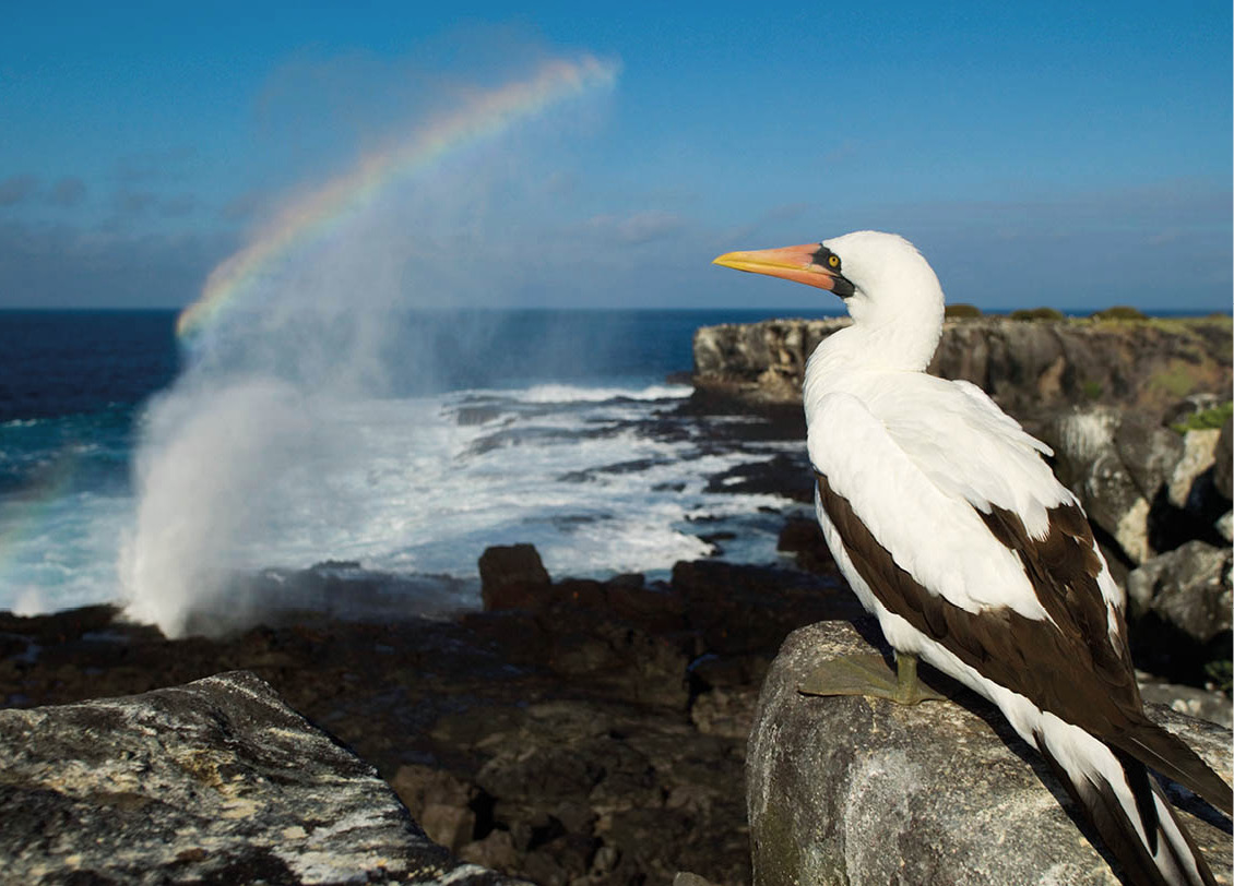
Nazca booby on Española.
DLILLC/Corbis
The whole astonishing range of sea-birds can be seen on this island, as well as the beautiful beach of Gardner’s Bay. Keep an eye out for the blowhole, which spouts water 50 meters (164ft) into the air whenever waves hit. At the eastern point of the archipelago lies San Cristóbal 5 [map] (Chatham), the -second-largest human population center after Santa Cruz: 5,500 people live in Puerto Baquerizo Moreno, the Galápagos’ provincial capital. The introduction of flights here caused a development boom, and several hotels and restaurants service the town. There is a small museum run by the Franciscan fathers, a monument to Darwin, and, at the entrance of the port, a rock called León Dormido (Sleeping Lion), which can be climbed for a good view of the island.
Quote
“As I shall refer to this subject again, I will only here remark, as forming a striking character on first landing, that the birds are strangers to man. So tame and unsuspecting were they, that they did not even understand what was meant by stones being thrown at them; and quite regardless of us, they approached so close that any number might have been killed with a stick.”
The Voyage of the Beagle, Charles Darwin”
A road leads to the village of El Progreso and the 895-meter (2,936ft) -high Volcán San Joaquín and El Junco, a freshwater crater lake. Frigatebird Hill is, as the name suggests, a good place to see frigate birds and only a short walk from the town. The nearby Galápagos National Park Visitor Center (tel: 05-252 1538; daily 7am–6pm), has a number of exhibits about the island’s natural history and ecosystems. La Lobería is a beach crowded with sea lions and Puerto Grande a small cove particularly popular for swimming.
Other far-flung islands include Marchena, Pinta, and Genovesa (Tower), which is home to the main colony of red-footed boobies, three types of Darwin’s finch, and everything from red-billed tropic-birds to storm petrels.