Introduction to the San Francisco Bay Area
The Bay Area is usually divided into four regions—North Bay, East Bay, South Bay, and Peninsula—and this guide follows that scheme, making a roughly clockwise circuit of the Bay, starting at the Golden Gate. The North Bay includes Marin, Napa, and Sonoma counties; the East Bay consists of Alameda and Contra Costa counties; the South Bay takes in most of Santa Clara County; and the Peninsula covers San Francisco, San Mateo, and the northwestern part of Santa Clara County. Within the Bay Area are bustling urban areas such as San Francisco, Oakland, San Jose, and Silicon Valley, along with tranquil forests, mountains, beaches, marshes, and farmlands.
The parks and open spaces here are administered by an alphabet soup of local, state, and federal agencies, including California State Parks (CSP); East Bay Regional Park District (EBRPD); Golden Gate National Recreation Area (GGNRA); Midpeninsula Regional Open Space District (MROSD); Santa Clara County Parks and Recreation; San Mateo County Parks; Marin Municipal Water District (MMWD); and Marin County Open Space District (MCOSD).
Geography
The San Francisco Bay Area is distinguished by its rolling hills, grassy valleys, and rugged mountain ranges, all encircling a great body of water, San Francisco and San Pablo bays, and bordering an even greater body of water, the Pacific Ocean.
The Bay Area lies within a geological province called the Coast Ranges, a complex system of ridges and valleys that stretches from Arcata to the north to near Santa Barbara in the south, and inland to the edge of the Central Valley. Several important subranges run through our area, including the Sonoma, Mayacamas, and Vaca mountains in the North Bay; the Diablo Range in the East Bay and South Bay; and the Santa Cruz Mountains on the Peninsula and in the South Bay. The tallest peak in the North Bay (and in this guide) is Mt. St. Helena (4339'). Other prominent Bay Area summits include Mt. Hamilton (4213'), Mt. Diablo (3849'), Loma Prieta (3806'), Mt. Tamalpais (2571'), and Sonoma Mountain (2295').
A lead player in the shaping of the Bay Area is the San Andreas Fault, which splits the Santa Cruz Mountains, passes under water seaward of the Golden Gate, and then slices through Point Reyes National Seashore. The Calaveras Fault, running along the Oakland hills and past Mission Peak, is a major offshoot of the San Andreas.
Movement along these faults, as the Pacific Plate bumps and grinds its way northwest against the North American Plate, is what rattles our teacups and collapses our freeways. Evidence of this movement can be found at the tip of Point Reyes and on Montara Mountain, where granite from the so-called Salinian Block, formed 25 million years ago near the southern end of the Sierra Nevada, has slowly shifted northward along the San Andreas Fault. Greenish serpentine rock, found near faults, creates a challenging growing environment favoring rare native shrubs and wildflowers.
Much of the rock underlying the Bay Area is sedimentary or metamorphic (sandstone, schist, and shales), but there are some delightfully unusual areas, such as the volcanic soils of Mt. St. Helena, Skyline Wilderness Park, and Sibley Volcanic Regional Preserve; granite on Montara Mountain; and the dark, red Franciscan chert of the Marin Headlands. The East Bay’s Black Diamond Mines Regional Preserve was a major coal mining area more than a century ago, and mercury was mined near Almaden Quicksilver County Park as recently as the 1970s.
Flora
Bay Area parks have an incredible diversity of plant life. California has more than 5000 native plant species and an estimated 1000 introduced species. Of the native plants, about 30 percent occur nowhere else—these are called endemics. Among the most common endemics are many types of manzanita (Arctostaphylos) and monkeyflower (Mimulus). The state has some of the oldest species, in terms of evolution, and also some of the youngest. For example, coast redwoods date back to the dinosaurs, whereas certain species of tarweed (Madia) have evolved within the past several thousand years.
The Bay Area’s dry interior hills, untouched by summer fog, are characterized by the oak woodland community, which is found at elevations between 300 and 3500 feet. Common trees and shrubs found in this generally open woodland, sometimes called a savanna, include various oaks, California buckeye, gray pine, California bay, buckbrush, toyon, coffeeberry, snowberry, and poison oak. Especially with oaks, slope aspect and elevation determine which species occur where. Excluding hybrids, there are six common oaks in the Bay Area—valley oak, black oak, blue oak, canyon oak, interior live oak, and coast live oak. Examples of this community can be found at Sugarloaf Ridge State Park, Black Diamond Mines Regional Preserve, and Henry W. Coe State Park.
Members of the riparian woodland are usually found be side rivers and creeks. Among the most common are bigleaf maple, white alder, red alder, California bay, various willows, California rose, poison oak, California wild grape, elk clover, and giant chain fern. Point Reyes National Seashore and Monte Bello Open Space Preserve give you opportunities to enjoy this community.
Coast redwoods are the world’s tallest trees and are among the fastest-growing. Redwood groves once formed an extensive coastal forest that stretched from central California to southern Oregon. Commercially valuable, they were heavily logged. The remaining old-growth coast redwoods in the Bay Area are confined to a few areas, most notably Muir Woods National Monument, in Marin County, and Armstrong Redwoods State Reserve, in northwest Sonoma County. Associated with redwoods are a number of plant species, including tanbark oak, California bay, hazelnut, evergreen huckleberry, wood rose, redwood sorrel, western sword fern, and evergreen violet. You can visit second-growth redwood forests and see a few old-growth giants at Muir Woods National Monument, Redwood Regional Park, and Purisima Creek Redwoods Open Space Preserve.
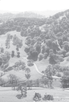
Oak woodland in Black Diamond Mines Regional Preserve
In many parts of the Bay Area, Douglas-fir is the “default” evergreen, easily told by its distinctive cones, which have protruding, three-pointed bracts, sometimes called rat’s tails. Douglas-fir and coast redwood are California’s two most important commercial trees. Douglas-fir often grows in similar habitats as coast redwood but where soil conditions do not favor redwood growth. Some of the common plants associated with Douglas-fir are the same as those associated with coast redwood, namely California bay, tanbark oak, and western sword fern. Others include blue blossom, coffeeberry, and poison oak. Point Reyes National Seashore, Mt. Tamalpais State Park, and El Corte de Madera Creek Open Space Preserve have beautiful Douglas-fir forests.
A mixed evergreen forest contains a mixture of evergreen trees, including California bay, canyon oak, coast live oak, and madrone. The understory to this forest often contains shrubs such as toyon, blue elderberry, hazelnut, buckbrush, snowberry, thimbleberry, creambush, and poison oak. Carpeting the forest floor may be an assortment of wildflowers, including milk maids, fairy bells, mission bells, hound’s tongue, and western heart’s-ease. Take a stroll through a mixed evergreen forest at China Camp State Park, Dry Creek Pioneer Regional Park, and Sierra Azul Open Space Preserve.
The chaparral community is made up of hardy plants that thrive in poor soils under hot, dry conditions. Chaparral is very susceptible to fire, and some of its members, such as various species of manzanita, survive devastating blazes by sprouting new growth from ground-level burls. Despite the harsh environment, chaparral can be beautiful year-round, with certain manzanitas blooming as early as December, and other plants continuing into spring and summer. The word itself comes from a Spanish term for “dwarf” or “scrub oak,” but in the Bay Area it is chamise, various manzanitas, and various species of ceanothus that dominate the community. Other chaparral plants include mountain mahogany, yerba santa, toyon, chaparral pea, and poison oak. You can study this fascinating assembly of plants on Mt. Tamalpais, Pine Mountain, Mt. Diablo, and in Sierra Azul Open Space Preserve.

Grassland and coastal scrub in the Marin Headlands host a wide variety of native wildflowers.
Few if any grasslands in the Bay Area retain their native character. Human intervention, in the form of fire suppression, farming, and livestock grazing, along with the invasion of nonnative plants, have significantly altered the landscape. Gone from most areas are the native bunchgrasses, perennial species that once dominated our area. Remaining, thankfully, are native wildflowers, which decorate the grasslands in spring and summer. Among the most common are bluedicks, California poppy, owl’s-clover, checkerbloom, lupine, and blue-eyed grass. Look for these at Skyline Wilderness Park, Sunol Wilderness, Joseph D. Grant County Park, and Russian Ridge Open Space Preserve.
Sudden Oak Death
Many Bay Area parks are infested with Phytophthora ramorum, a plant pathogen that kills tanbark oak, coast live oak, black oak, and canyon live oak. This pathogen also infects other trees and shrubs, including California bay, madrone, rhododendron, bigleaf maple, huckleberry, California buckeye, manzanita, toyon, coast redwood, and Douglas-fir. Its spores may spread via water, soil, and infected plant material. For more information, visit the California Oak Mortality Task Force’s Web site: www.suddenoakdeath.org.
 OPTIONS
Help Stop the Spread of Sudden Oak Death
| • | Avoid parking your vehicle in muddy areas. |
| • | Stay on established trails. |
| • | Avoid walking or riding through damp soil or mud. |
| • | Do not collect any plant material, including leaves, flowers, acorns, wood, and bark. |
| • | Clean soil and mud off shoes, bikes, pets’ paws, and vehicles to prevent spreading spores via contaminated soil to new areas. |
Fauna
Besides deer, rabbits, and squirrels, you probably won’t see many other land mammals on your hikes in the Bay Area, unless you time your visits near dawn or dusk. These are times when most mammals are active, and then you may be rewarded with a fleeting glimpse of a coyote or a bobcat. Large mammals, such as black bears and mountain lions, are seldom seen. Other more common mammals in our area include foxes, raccoons, skunks, opossums, and chipmunks. Wild pigs are present in Bay Area parks, and in some they have done extensive damage. Never approach wild pigs; they are dangerous. In many East Bay and South Bay parks, you may encounter cows on or near the trail. Though they are often sweet-tempered, give them plenty of space, and never get between cows and their calves.

Birders are lucky in the Bay Area.
It is not hyperbole to call the Bay Area one of the world’s great birding areas. Its location on the western edge of the Pacific Flyway, combined with the presence of so many different habitats, from offshore islands to inland mountains, guarantees both a high species count and an enormous number—in the millions—of individual birds either resident, wintering, or passing through on their migration. Point Reyes National Seashore, perhaps the area with the most variety of birds, has logged an impressive 440 different species, or just under half of all bird species found in North America north of Mexico. The American Ornithologists’ Union’s (AOU) checklist for birds of the continental US and Canada is the standard reference for common names of birds.
Season, location, weather, and even time of day—these together help determine which birds you are likely to see. Among the most common birds seen from the trail are acorn woodpeckers, western scrub-jays, Steller’s jays, spotted towhees, dark-eyed juncos, California quail, and turkey vultures. Raptors such as hawks, falcons, golden eagles, and kites patrol the skies above many Bay Area parks. If you learn to “bird by ear,” identifying species by their distinctive notes, calls, and songs, you will quickly expand your list, because many birds are frustratingly hard to spot, especially in dense foliage. Birding with a group also improves your odds of seeing and identifying a large number of species, including rarities.
If a sudden scurrying in the leaves takes you by surprise, it is probably nothing more than a western fence lizard, the Bay Area’s most commonly seen reptile. When threatened, these lizards may stand their ground and begin to do “push-ups,” which perhaps strike terror into their foes. Also here are the California whiptail, a lizard with a tail as long as its body, the alligator lizard, and the western skink. An animal resembling a lizard but actually an amphibian is the California newt, which spends the summer buried under the forest floor, then emerges with the first rains and migrates to breed in ponds and streams. Briones Regional Park and Monte Bello Open Space Preserve are among good places to witness these migrations. Other amphibians you might see or hear include western toads and Pacific tree frogs.
Gopher snake, California kingsnake, rubber boa, California whipsnake, western rattlesnake, and garter snake are among the snakes present in the Bay Area. Gopher snakes are often mistaken for rattlers, and for a heart-stopping moment you may struggle to recall the differences: A gopher snake has a slim head and a fat body, whereas a rattlesnake has a relatively thin body compared with its large, triangular head. Gopher snakes are common, but rattlers, although present in the Bay Area, are seldom seen.
Seasons
Where else can you find such a perfect climate for outdoor activities? Not too hot in summer, not too cold in winter, and a rain-free season that lasts generally from May through October. The moderating effect of the Pacific Ocean keeps temperatures near the coast in a narrow range year-round. The summer months are characterized by fog at the coast but generally clear and warm conditions elsewhere. The shady canyons of Marin County and the Peninsula are perfect summer places to cool off. If you want to bake on the trail, head away from the Bay.
By the time fall arrives, the hills are brown and seasonal creeks dry. These clear, cool days are perfect just about everywhere, with a modest palette of autumn colors in riparian areas. With the first rains, the change is dramatic: Hillsides turn green and water returns to the creek beds.
Fall and winter storms from the Gulf of Alaska can bring copious rainfall, high winds, and even snow to the tallest Bay Area peaks. In their wakes these storms usually leave a few exceptionally cold but clear days, perfect for bundling up and visiting a vantage point with great views, such as Mt. Tamalpais or even Mt. St. Helena.
As early as December, our manzanitas and currants begin to bloom, decorating chaparral areas with floral displays of white and pink. Other shrubs and the earliest wildflowers begin their show in late winter or early spring. By the time April rolls around, especially after a wet winter, the wildflower display is usually fantastic, so this is the time to head to the grasslands of the East Bay and the Peninsula.
The farther inland you go, the less pronounced is the moderating influence of the ocean. Temperature differences—the average highs and lows for any given location—widen as you leave the coast. Here’s an example, using two locations about 65 miles apart: The highest average high temperature for San Francisco is 68.5°F, whereas the same figure for St. Helena in Napa County is 89.2°F. But San Francisco’s lowest average minimum, 45.7°F (January), is about 10°F warmer than St. Helena’s.
Similarly, rainfall varies as you move around the Bay Area. Each successive range of coastal hills blocks more and more Pacific moisture, creating a rain-shadow effect that intensifies as you move away from the coast and from San Francisco Bay. That is why coast redwoods, which depend on fog-drip to supply moisture during the dry season, grow only in a narrow band near the coast.
Time of day and weather conditions are often as important as time of year when considering a route. A hike that is pleasant in the cool of the morning can be a sweltering ordeal under the noonday sun if there is no shade. An outing can be spoiled (or otherwise transformed) by high winds or a sudden squall. Always check for the most current weather before heading out for the day.
Trail Selection
The goal of this guide is to steer you to the best parks and open spaces in the Bay Area, and also to encourage you to explore on your own. Of course, every book reflects its authors’ interests. With so many possible parks, trails, and habitats to choose from, how were the 44 trails in this guide chosen?
Key Features
Taking the series name literally, many of these “top” trails climb high. Outdoor enthusiasts love vantage points with great views but some also climb for sheer enjoyment. So, you will find an assortment of the Bay Area’s tallest peaks—Mt. St. Helena, Mt. Tamalpais, Mt. Diablo, and Black Mountain—represented here.
If long-distance routes sound like fun, check out Annadel State Park, Point Reyes National Seashore, Black Diamond Mines Regional Preserve, Pleasanton Ridge Regional Park, Almaden Quicksilver County Park, and Purisima Creek Redwoods Open Space Preserve. (If short strolls are your preference, many of the trips suggest shorter options.)
If you have a passion for water, you’ll enjoy exploring Mt. Burdell Open Space Preserve, which has a large vernal pool with rare wildflowers; Redwood Regional Park, where coast redwoods rise majestically above a rushing creek; and Monte Bello Open Space Preserve, where a self-guiding nature trail wanders through the canyon holding Stevens Creek.
If you are interested in wildflowers and native plants—from tiny flowers to towering redwoods—head for the Marin Headlands, Henry W. Coe State Park, and Russian Ridge Open Space Preserve. Birders may see birds ranging from hawks to hummingbirds just about anywhere in the Bay Area.
Finally, many of the trails in even our remotest parks and preserves touch on the Bay Area’s fascinating human history, from the earliest Native Americans to today’s Silicon Valley entrepreneurs. Many of these trails take you through terrain once trod by Ohlone Indians, Spanish missionaries, Mexican ranchers, Italian winemakers, Portuguese dairymen, Chinese fishermen, and a host of famous and infamous personalities. Without this human history, and generations of environmental activists working to save our hills and shorelines from encroaching development, our experience of the Bay Area’s landscape would be much less rich.
Multiple Uses
Many of the trails in the Bay Area are multiuse trails, which means they are shared by hikers, bicyclists, runners, and equestrians—most of these are actually dirt roads. In general, bicycles are not permitted on single-track trails. Exceptions, including Annadel and China Camp state parks and some MROSD preserves, are noted in the text. Whenever possible, if a route described has a segment closed to bikes, the text provides alternate trails that are open. A few trails, designated “hiking only,” are closed to both bikes and horses.
Some agencies, such as MROSD, close their multiuse trails to bikes and horses during wet weather, with special gates that allow hikers to pass. Where this is the case, it is noted in the text. Call ahead to the agency in charge of the park or open space you are planning to visit, and have an alternate route selected. Agency phone numbers and their Web site addresses, if any, are listed in Appendix 2.
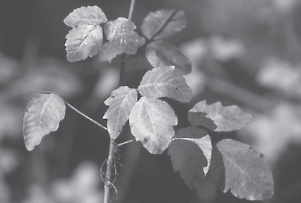
Poison Oak Learn to recognize the stems and lobed leaves in all seasons.
When planning a hike with your dog, check to make sure pets are allowed. Dogs (and other pets) are not allowed on the trails in any Bay Area state park, and there are restrictions at other parks and open spaces as well. Where dogs are allowed, they generally must be on a leash no longer than 6 feet. Some agencies allow dogs off-leash, but the dogs must be under immediate voice command of the person they are with, and must never be allowed to threaten or harm people or wildlife. People with dogs must clean up after their pets and obey all other posted rules and regulations.
Trail Safety
Poison oak produces an itchy rash in people allergic to its oil. Learn to identify poison oak’s shiny green foliage—“leaflets three, let it be”—and avoid it. In fall the shrub’s leaves turn yellow and red, adding a wonderful touch of color to the woods. In winter, you can identify the plant by its upward-reaching clusters of bare branches. Staying on the trail is the best way to avoid contact with poison oak, and wearing long pants and a long-sleeved shirt helps too. Anything that touches poison oak—clothing or pets, for instance—should be washed in soap and water.
The tick, a tiny, almost invisible insect, has been the cause of much woe among hikers and others who spend time outdoors. Western black-legged ticks carry a bacteria that causes Lyme disease, which can produce serious symptoms in people who have been bitten. These include flulike aches and pains which, if left untreated, may progress to severe cardiac and neurological disorders. Often the tick bite produces a rash that over time clears from the center, producing a bull’s-eye pattern.
You can take several steps to protect against Lyme disease. Wear light-colored clothing, so ticks are easier to spot. Use long-sleeved pants with the legs tucked into your socks (or gaiters over the bottom of your pants and tops of your shoes), and a long-sleeved shirt tucked into your pants. Spray your clothing with an insect repellent containing DEET before hiking. When you return home, shake out and brush all clothing, boots, and packs outdoors. If you find an attached tick, use tweezers to remove it by grasping the tick as close to your skin as possible and steadily pulling it out. Do not squeeze the tick while it is attached, as this may inject the bacterium into your skin. Wash the area and apply antiseptic, then call your doctor.
Although present in the Bay Area, western rattlesnakes are shy and seldom seen. Most snake bites are the result of a defensive reaction: A foot or hand has suddenly landed in the snake’s territory. A rattlesnake often, but not always, gives a warning when it feels threatened. Stand still until you have located the snake, and then back slowly away. If you are bitten, seek medical attention as quickly and effortlessly as possible, to avoid spreading the venom.
Mountain lions, also called cougars or pumas, are rarely seen in our area. They hunt at night and feed mostly on deer. If you do encounter a mountain lion, experts advise standing your ground, making loud noises, waving your arms to appear larger, and fighting back if attacked. Above all, never run: You want to avoid being seen as prey by the mountain lion.
Note from the Authors
During the course of several years, we walked every trail included in this guide at least once. In many cases, we returned to favorite areas in different seasons. We try to be accurate and thorough in both our observations and our writing. The natural world, however, is always in a state of flux, and although this is a fine thing in general, it plays havoc with outdoor guides. Your experience on the trail—affected as it is by season, weather, time of day, and acts of God and various federal, state, and local agencies—will very likely be different from ours. We acknowledge this variability by the use of the word “may” in the text, as in “As you tromp along the trail, you may scare up a covey of California quail.” We certainly hope you get to see the quail, but like so many other things, the movement of birds is beyond our control.