Chapter 11: Bryce Canyon National Park
If you can visit only one national park in your lifetime, make it Bryce Canyon ★★★, a place full of magic, inspiration, and spectacular beauty. The main draw of the park is the thousands of intricately shaped hoodoos: those silent rock sentinels and congregations gathered in colorful cathedrals, arranged in formations that invite your imagination to run wild.
Geologically speaking, hoodoos are simply pinnacles of rock, often oddly shaped, left standing after millions of years of water and wind have eroded the surrounding rock. But perhaps the real truth lies in a Paiute legend. These American Indians, who lived in the area for several hundred years before being forced out by Anglo pioneers, told of “Legend People” who once lived here; because of their evil ways, they were turned to stone by the powerful Coyote and even today remain frozen in time.
Whatever the cause, mythical or scientific, Bryce Canyon is certainly unique. Its intricate and often whimsical formations are on a more human scale than the impressive rocks seen at Zion, Capitol Reef, and Canyonlands national parks. And Bryce is far easier to explore than the huge and sometimes intimidating Grand Canyon. Bryce is comfortable and inviting in its beauty; by gazing over the rim, or spending even just one morning on the trail, you will feel you’re on intimate terms with the park.
Although the colorful hoodoos first grab your attention, it isn’t long before you notice the deep amphitheaters, with their cliffs, windows, and arches, all colored in shades of red, brown, orange, yellow, and white that change and glow with the rising and setting sun. Beyond the rocks and light are the other faces of the park: three separate life zones at the various elevations in the park, each with its own unique vegetation, and a kingdom of animals, from the busy chipmunks and ground squirrels to the stately mule deer and its archenemy, the mountain lion.
Human exploration of the Bryce area likely began with the Paiute. It’s possible that trappers, prospectors, and early Mormon scouts visited here in the early to mid-1800s before Major John Wesley Powell conducted the first thorough survey of the region in the early 1870s. Shortly after Powell’s exploration, Mormon pioneer Ebenezer Bryce and his wife, Mary, moved to the area and tried raising cattle. Although they stayed only a few years before moving on to Arizona, Bryce left behind his name and his oft-quoted description of the canyon as “a helluva place to lose a cow.”
Bryce Canyon National Park

Just the Facts
Getting There/Access Points Bryce Canyon Airport (Airport Code BCE;  435/834-5239; www.brycecanyonairport.com), at 7,586 feet of elevation, is located several miles from the park entrance on Utah 12, and has a 7,400-foot lighted runway. There is no regularly scheduled airline service, but charter service is available from Bryce Canyon Airlines ( 435/834-8060; www.rubysinn.com/bryce-canyon-airlines.html). There is a free shuttle service to local motels, and car rentals are available from Hertz ( 800/654-3131; www.hertz.com), located at the Chevron service station in the Ruby’s Inn complex.
You can also fly into St. George (130 miles southwest of the park on I-15) or Cedar City (also on I-15, about 80 miles west of the park), and rent a car (see chapter 9).
From St. George, travel north on I-15 10 miles to exit 16, then head east on Utah 9 for 63 miles to U.S. 89, north 44 miles to Utah 12, and east 13 miles to the park entrance road. The entrance station and visitor center are just 3 miles south of Utah 12. From Cedar City (I-15 exits 57, 59, and 62), take Utah 14 west 41 miles to its intersection with U.S. 89, and follow U.S. 89 north 21 miles to Utah 12, then east 17 miles to the park entrance road.
Situated in the mountains of southern Utah, the park is traversed east to west by Utah 12, with the bulk of the park, including the visitor center, accessible via Utah 63, which branches off from Utah 12 and goes south into the heart of the park. Utah 89 runs north-south west of the park, and Utah 12 heads east to Tropic and Escalante.
From Salt Lake City, it’s approximately 240 miles to the park. Take I-15 south about 200 miles to exit 95, head east 13 miles on Utah 20, south on U.S. 89 for 17 miles to Utah 12, and east on Utah 12 for 13 miles to the park entrance road.
From Capitol Reef National Park, take Utah 24 west 10 miles to Torrey, and turn southwest onto Scenic Highway Utah 12 (through Boulder and Escalante) for about 110 miles, until you reach the park entrance road.
Bryce is 83 miles east of Zion National Park and 250 miles northwest of Las Vegas, Nevada.
Getting Around To alleviate congestion along the park’s only road, a free shuttle service is in effect from early May to early October, daily from 8am until 7:40pm (until 5:40pm the last few weeks of the shuttle season). Visitors can park their cars at the parking and boarding area at the intersection of the entrance road and Utah 12, 3 miles from the park boundary, and ride the shuttle into the park. Those staying in the park at the Lodge at Bryce Canyon or one of the campgrounds can also use the shuttle. The shuttle has stops at various viewpoints, as well as Ruby’s Inn, Ruby’s Campground, the visitor center, Sunset Campground, and the Lodge at Bryce Canyon. It runs every 12 to 15 minutes. Note that using the shuttle is not required; you can use your own car if you wish.
Information/Visitor Center For advance information, contact the park at P.O. Box 640201, Bryce, UT 84764-0201 ( 435/834-5322; www.nps.gov/brca). Officials request that you write rather than call, at least a month before your planned visit, for them to mail you information. However, you can find everything they will send you and more at the park website. You can also get information at www.twitter.com/brycecanyonnps and at www.facebook.com/brycecanyonnps. If you desire even more details to help plan your trip, you can order books, maps, posters, DVDs, and CDs from the nonprofit Bryce Canyon Natural History Association, P.O. Box 640051, Bryce, UT 84764-0051 ( 888/362-2642 or 435/834-4782; www.brycecanyon.org). Association members (membership costs $35 single or $50 family annually) receive a 15% discount on purchases and also receive discounts at the Bryce Lodge gift shop and most other nonprofit bookstores at national parks, monuments, historic sites, and recreation areas.
The visitor center, at the north end of the park, has exhibits on the geology and history of the area and a short slide show on the park. Rangers can answer questions and provide backcountry permits. Free brochures are available, and books, maps, videos, and posters can be purchased. The visitor center is open daily year-round except Thanksgiving, Christmas, and New Year’s Day. Summer hours are usually from 8am to 8pm, with shorter hours the rest of the year (in the dead of the winter, the visitor center will close at 4:30pm).
 Bryce Canyon in Outer Space
The International Astronomical Union has officially named the minor planet 49272 as Bryce Canyon. Hundreds of thousands of minor planets, which most of us call asteroids, orbit the sun and range in size from several yards to hundreds of miles across. The Bryce Canyon asteroid, estimated to be 3 to 5 miles across, orbits the sun between Mars and Jupiter, but is too dim to be seen with a small telescope. Even visitors who participate in the park’s popular twice-weekly summertime Astronomy Program ★ (telescopes provided; consult the visitor center for details and dates) won’t be able to see the park’s celestial namesake. But don’t worry: On a clear night, there’s always plenty to see.
Fees, Backcountry Permits & Regulations Entry into the park (for up to 7 days) costs $25 per private car, pickup truck, van, or RV, which includes unlimited use of the park shuttle (when it’s operating). Individuals 16 and older entering the park on motorcycle, bike, or foot are charged $12 each; those 15 and under are admitted free. Campsites cost $15 per night.
Backcountry permits are required for all overnight trips into the backcountry, and for up to 7 days cost $5 for 1 or 2 people, $10 for 3 to 6 people, and $15 for 7 to 15 people (group sites only). Backcountry camping is permitted on only two trails (see “Hiking,” below).
Backcountry hikers are expected to practice minimum-impact techniques, prohibited from building fires, and required to carry their own water. Bicycles are prohibited in the backcountry and on all trails. Feeding or disturbing wildlife is forbidden, as is vandalizing or upsetting any natural feature of the park. Dogs, which must be leashed at all times, are prohibited on all trails, in the backcountry, and in public buildings.
Seasons/Avoiding the Crowds Although Bryce Canyon National Park receives only two-thirds the number of annual visitors that pour into Zion, the park can still be crowded, especially during peak season from June through September, when the campgrounds are often full by 2pm. If you visit then, head for some of the lesser-used trails (ask rangers for recommendations), and start your hike as soon after sunrise as possible.
A better time to visit, if your schedule allows, is spring or fall; if you don’t mind a bit of cold and snow, the park is practically deserted from December through February—and the sight of bright red hoodoos capped with fresh white snow is something you won’t soon forget.
Safety While most visitors to Bryce Canyon enjoy an exciting vacation without mishap, accidents can occur, and here—possibly because of the nature of the trails—the most common injuries by far are sprained, twisted, and broken ankles. Park rangers strongly recommend that hikers—even those just out for short day hikes—wear sturdy hiking boots with good traction and ankle support. When hiking, remember that the lower you drop below the rim, the hotter it gets, so carry lots of water and dress in layers that can be removed and easily carried as the temperature rises.
Another concern in the park is bubonic plague, which, contrary to popular belief, is treatable with antibiotics if caught in its early stages. The bacteria that causes bubonic plague has been found on fleas in prairie dog colonies in the park, so you should avoid contact with wild animals, particularly prairie dogs, chipmunks, ground squirrels, and other rodents. Those taking pets into the park should first dust them with flea powder.
Ranger & Educational Programs Park rangers present a variety of free programs and activities. One-hour evening programs, which may include a slide show, take place at the Lodge at Bryce Canyon, the visitor center, and occasionally at the North Campground amphitheater. Topics vary but may include such subjects as the animals and plants of the park, the park’s geology, and the role of humans in the park’s early days. Rangers also give half-hour talks several times daily at various locations in the park and lead hikes and walks, including a moonlight hike ★★ (reservations required, so sign up at the visitor center) and a wheelchair-accessible, 1 1/2-hour canyon rim walk ★★. Schedules are posted on bulletin boards at the visitor center, General Store, campgrounds, and the Lodge at Bryce Canyon. Especially popular are the park’s Astronomy Programs ★, which are usually offered 3 evenings a week through the summer. Telescopes are provided.
The High Plateaus Institute, which is affiliated with Bryce Canyon Natural History Association, occasionally presents educational programs for the public. For details, check with park offices or the Bryce Canyon Natural History Association ( 888/362-2642 or 435/834-4782; www.brycecanyon.org).
During the summer, children 12 and younger can join the Junior Rangers for a nominal fee. Junior Rangers participate in a variety of programs, and earn certificates and patches; booklets are available at the visitor center. In addition, park rangers periodically conduct special kids’ activities—usually lasting about an hour and a half—on subjects such as the park ecology. Reservations are required—contact the visitor center for information.
 Getting a Bird’s-Eye View of the Park
For an unforgettable view of the canyon, contact Bryce Canyon Airlines & Helicopters ( 435/834-8060; www.rubysinn.com/bryce-canyon-airlines.html) for scenic flights by helicopter or open cockpit biplane. Tours last from about 35 minutes to several hours, and the longer trips include surrounding attractions. Prices start at about $100 per person, and reservations are required.
Seeing the Highlights
Because Bryce Canyon is a relatively compact and easily accessible park, it is possible to see a good deal of it in a short amount of time.
Start at the visitor center and watch the short slide show that explains some of the area geology. Then drive the 18-mile (one-way) dead-end park road, stopping at viewpoints (see “Exploring Bryce Canyon by Car,” below). An alternative is to take the shuttle system (see “Getting Around,” ), which will take you to most of the main viewpoints.
Whichever way you choose to get around, make sure you spend at least a little time at Inspiration Point, which offers a splendid (and yes, inspirational) view of Bryce Amphitheater and its hundreds of statuesque pink, red, orange, and brown hoodoo stone sculptures.
After seeing the canyon from the top down, walk at least partway down the Queen’s Garden Trail. If you can spare 3 hours, hike down the Navajo Loop Trail and return to the rim via the Queen’s Garden Trail. Those not willing or physically able to hike into the canyon can enjoy a leisurely walk along the Rim Trail, which provides spectacular views into the canyon. The views are especially gorgeous about an hour before sunset. In the evening, try to take in the campground amphitheater program.
Top Picnic Spot
On a hot summer day, the best spot in the park for a picnic lunch is Rainbow Point, which has picnic tables and restrooms. It’s also among the coolest areas because, at 9,115 feet of elevation, it’s the highest point in the park.
Exploring Bryce Canyon by Car
The park’s 18-mile scenic drive (one-way) follows the rim of Bryce Canyon, offering easy access to a variety of views into the fanciful fairyland of stone sculptures below. Trailers are not permitted on the road, but can be left at several parking lots. All the overlooks are on your left as you begin your drive, so it’s best to drive all the way to the end of the road and stop at the overlooks on your return trip. Allow 1 to 2 hours.
From the visitor center, drive 18 miles to Yovimpa and Rainbow Point overlooks, which offer expansive views of southern Utah, Arizona, and often even New Mexico. From these pink cliffs, you can look down on a colorful platoon of stone soldiers, standing at eternal attention. A short loop trail from Rainbow Point leads to an 1,800-year-old bristlecone pine, believed to be the oldest living thing at Bryce Canyon.
From here, drive back north to Ponderosa Canyon Overlook, where you can gaze down from a dense forest of spruce and fir at multicolored hoodoos, before continuing to Agua Canyon Overlook, which has views of some of the best color contrasts in the park. Looking almost straight down, watch for a hoodoo known as the Hunter, wearing a hat of green trees.
Now continue on to Natural Bridge, actually an arch carved by rain and wind and spanning 85 feet. From here, go on to Farview Point for a panoramic view to the distant horizon and the Kaibab Plateau at the Grand Canyon’s north rim. Passing through Swamp Canyon, turn right off the main road to three viewpoints, the first of which is Paria View, with views to the south of the light-colored sandstone White Cliffs, carved by the Paria River. To the north of Paria View is Bryce Point, a splendid stop for seeing the awesome Bryce Amphitheater, the largest natural amphitheater in the park, as well as distant views of the Black Mountains to the northeast and the Navajo Mountain to the south. From here, it’s just a short drive to Inspiration Point, offering views similar to those at Bryce Point plus the best vantage point for seeing the Silent City, a sleeping city cast in stone.
Return to the main road and head north to Sunset Point, where you can see practically all of Bryce Amphitheater, including the aptly named Thor’s Hammer and the 200-foot-tall cliffs of Wall Street.
Continue north to a turnoff for your final stop at Sunrise Point, which has an inspiring view into Bryce Amphitheater. This is the beginning of the Queen’s Garden Trail ★★, an excellent choice for a walk below the canyon’s rim.
The Best Time to Make the Scenic Drive
The scenic drive is practically deserted in early mornings—any time before 9am. This is the best time to see deer, and the light on the hoodoos is at its richest during this time.
Outdoor Pursuits
In addition to the activities in Bryce Canyon National Park, the adjacent national forest has its own share of outdoor activities. For information, stop at the Dixie National Forest’s Red Canyon Visitor Center ( 435/676-2676), along Utah 12, about 11 miles west of the Bryce Canyon National Park entrance road. It’s usually open daily from early May to early October, and offers various interpretative programs on many Saturdays. Or contact the Dixie National Forest Information Center, 345 E. Riverside Dr., St. George, UT 84790 ( 435/688-3246; www.fs.fed.us/dxnf).
Biking & Mountain Biking
The park’s established scenic drive is open to cyclists, but bikes are prohibited on all trails and forbidden from traveling cross-country within the national park boundaries.
Because mountain bikers are not welcome on national park hiking trails, you have to leave Bryce in search of trails. Fortunately, you won’t have to go far. Dave’s Hollow Trail ★ starts at the Bryce Canyon National Park boundary sign on Utah 63 (the park entrance road) about a mile south of Ruby’s Inn. The double-track trail goes west for about a half-mile before connecting with Forest Road 090, where you turn south and ride for about 3⁄4 of a mile before turning right onto an easy ride through Dave’s Hollow to the Dave’s Hollow Forest Service Station on Forest Road 087. From here, you can retrace your route for an 8-mile round-trip ride; for a 12-mile trip, turn right on Forest Road 087 to Utah 12 and then right again back to Utah 63 and the starting point. A third option is to turn left on Forest Road 087 and follow it to Tropic Reservoir (see “Fishing,” below). This part of the journey does not form a loop, so you would turn around once you’ve reached the reservoir.
Fishing
The closest fishing hole to the park is Tropic Reservoir, a large lake in a ponderosa pine forest. From the intersection of Utah 63 (the park entrance road) and Utah 12, drive west about 3 miles to a gravel road, then about 7 miles south. Facilities include a forest service campground open in summer, a boat ramp, and fishing for rainbow, brook, and cutthroat trout. Locals say the fishing can be better in streams above the lake than in the reservoir itself. For more information, contact the Dixie National Forest (see above).
Hiking
One of Bryce Canyon’s greatest assets is that you don’t have to be an advanced backpacker to really get to know the park. However, all trails below the rim have at least some steep grades, so wear hiking boots with a traction tread and good ankle support to avoid ankle injuries. During the hot summer months, go hiking either early or late in the day, carry plenty of water, and keep in mind that the deeper you go into the canyon, the hotter it gets.
The Rim Trail, which does not drop into the canyon but offers splendid views from above, meanders along the rim for more than 5 miles. Overlooking Bryce Amphitheater, the trail offers excellent views along much of its length. An easy to moderate walk, it includes a .5-mile section between two overlooks—Sunrise and Sunset—that is suitable for wheelchairs. This trail is a good choice for an after-dinner stroll, when you can watch the changing evening light on the rosy rocks below.
Your best bet for getting down into the canyon and seeing the most with the least amount of sweat is to combine two popular trails—Navajo Loop and Queen’s Garden ★★★. The total distance is just under 3 miles, with a 521-foot elevation change, and it takes most hikers from 2 to 3 hours to complete the trek. It’s best to start at the Navajo Loop Trail head at Sunset Point and leave the canyon on the less-steep Queen’s Garden Trail, returning to the rim at Sunrise Point, .5 mile to the north. The Navajo Loop Trail section is considered fairly strenuous; Queen’s Garden Trail is rated moderate. Along the Navajo Loop Trail section, you’ll pass Thor’s Hammer—wondering why it hasn’t fallen—and then ponder the towering skyscrapers of Wall Street. Turning onto the Queen’s Garden Trail, you’ll see some of the park’s most fanciful formations—including majestic Queen Victoria herself, for whom the trail was named—plus the Queen’s Castle and Gulliver’s Castle.
Those up for a challenge might consider the Hat Shop Trail, a strenuous 4-mile round-trip with a 1,336-foot elevation change. Leaving from the Bryce Point Overlook, the trail drops quickly to the Hat Shop, so-named for the hard gray “hats” perched on narrow reddish-brown pedestals. Allow 4 hours.
For die-hard hikers who don’t mind rough terrain, Bryce has two backcountry trails, usually open in summer only. The Under-the-Rim Trail runs for some 23 miles, providing an excellent opportunity to see the park’s spectacular scenery on its own terms. Riggs Spring Loop Trail, 8.5 miles long, offers splendid views of the pink cliffs in the southern part of the park. The truly ambitious can combine the two trails for a weeklong excursion. Permits, available at the visitor center, are required for all overnight trips into the backcountry. They cost $5 for 1 or 2 people, $10 for 3 to 6 people, and $15 for 7 to 15 people (group sites only).
Horseback Riding
To see Bryce Canyon the way the early pioneers did, you need to look down from a horse. Canyon Trail Rides ( 435/679-8665; www.canyonrides.com) offers a close-up view of Bryce’s spectacular rock formations from the relative comfort of a saddle. The company has a desk inside Bryce Lodge. A 2-hour ride to the canyon floor and back costs $50 per person, and a half-day trip farther into the canyon costs $75 per person. Rides are offered April through November. Riders must be at least 7 years old for the 2-hour trip, at least 10 for the half-day ride, and weigh no more than 220 pounds.
Guided horseback rides in Red Canyon are offered by several companies, including Ruby’s Inn Horse Rides ( 866/782-0002 or 435/834-5341; www.horserides.net), at Ruby’s Inn. Rates are $45 for a 1-hour ride, $75 to $85 for a half-day ride, and $125 for a full day, including lunch. Ruby’s will also board your horse (call for rates).
Wildlife-Watching
The park is home to a variety of wildlife, ranging from mule deer to mountain short-horned lizards, which visitors often spot while hiking down into the canyon. Occasionally you might catch a glimpse of a mountain lion, most likely on the prowl in search of a mule-deer dinner; elk and pronghorn may also be seen at higher elevations.
The Utah prairie dog, listed as a threatened species, is actually a rodent. It inhabits park meadows, but should be avoided, as its fleas may carry disease (see “Safety,” earlier in this chapter).
There are many birds in the park; you’re bound to hear the obnoxious call of the Steller’s jay. Watch for swifts and swallows as they perform their exotic acrobatics along cliff faces; binoculars will come in handy.
The Great Basin rattlesnake should be given a wide berth. Sometimes more than 5 feet long, this rattler is the park’s only poisonous reptile. However, like most rattlesnakes, it is just as anxious as you are to avoid confrontation.
Spotting Peregrine Falcons
For a good chance to see peregrine falcons, go to Paria View, sit quietly away from the crowds, and then look out over the amphitheater, where these beautiful birds can often be spotted.
Winter Fun
Bryce is beautiful in the winter, when the white snow creates a perfect frosting on the red, pink, orange, and brown statues standing proudly against the cold winds. Cross-country skiers will find several marked, ungroomed trails (all above the rim), including the Fairyland Loop Trail ★★, which leads 1 mile through a pine and juniper forest to the Fairyland Point Overlook. From here, take the 1-mile Forest Trail back to the road, or continue north along the rim for another 1 1/4 miles to the park border.
Snowshoeing is allowed anywhere in the park except on cross-country-ski tracks. There are also connections to ski trails in the adjacent national forest.
Stop at the visitor center for additional trail information, and go to Best Western Plus Ruby’s Inn, just north of the park entrance ( 866/866-6616 or 435/834-5341; www.rubysinn.com), for information on cross-country ski trails, snowshoeing, and snowmobiling opportunities outside the park. Ruby’s grooms more than 30 miles of ski trails and also rents snowshoes and cross-country ski equipment.
Winter Safety
Although the entire park is open to cross-country skiers, rangers warn that it’s extremely dangerous to try to ski on the steep trails leading down into the canyon.
Camping
In the Park
Typical of the West’s national park campgrounds, the two campgrounds at Bryce offer plenty of trees for a genuine “forest camping” experience, easy access to trails, and limited facilities. North Campground ★ has 101 sites; Sunset Campground has 102 sites. One section in North Campground is open year-round; Sunset Campground is open late spring through early fall only. North Campground is best because it’s closer to the Rim Trail—making it easier to rush over to catch those amazing sunrise and sunset colors—but any site in either campground is fine. Neither has RV hookups or showers, but both have modern restrooms with running water. Reservations are available from early May through late September for North Campground and for 20 tent-only sites in Sunset Campground ( 877/444-6777; www.recreation.gov) for an additional booking fee of $10, regardless of the number of days. If you don’t have reservations, get to the campground early to claim a site (usually by 2pm in summer). Cost is $15 per night at both campgrounds.
Showers ($2), a coin-operated laundry, a snack bar, bundles of firewood, food and camping supplies, and souvenirs are located at the General Store (for information, contact the Lodge at Bryce Canyon; 435/834-5361), which is usually open daily from mid-April through October. The store is a healthy walk from either campground. The park service operates an RV dump station ($2 fee) in the summer.
Nearby
In addition to the campgrounds listed below, there is camping at Kodachrome Basin State Park.
King Creek Campground Located above Tropic Reservoir, this forest service campground, at 7,900 feet elevation, has graded gravel roads and sites nestled among tall ponderosa pines. Facilities include flush toilets, drinking water, and an RV dump station ($5 fee), but no showers or RV hookups. The reservoir has a boat ramp (see “Fishing,” above). To get to the campground from the Bryce Canyon National Park entrance, go north 3 miles on Utah 63 to Utah 12, turn west (left), and go 2 1/2 miles to the King’s Creek Campground Road; turn south (left) and follow signs to Tropic Reservoir for about 7 miles to the campground.
Dixie National Forest Information Center, 345 E. Riverside Dr., St. George, UT 84790. www.fs.fed.us/dxnf.  435/688-3246. 37 sites. $10. No credit cards. Closed Oct to mid-May.
Ruby’s Inn RV Park & Campground Ruby’s is the closest campground to Bryce Canyon National Park that offers complete RV hookups, and it’s also on the park’s shuttle-bus route. Many sites are shaded, there’s an attractive tent area, and just adjacent to the campground are a lake and horse pasture. Facilities include a swimming pool, coin-op laundry, barbecue grills, and a store with groceries and RV supplies. Also on the grounds are several camping cabins ($56 double) and tepees ($34 double), which share the campground’s bathhouse and other facilities.
300 S. Main St., Bryce Canyon City, UT 84764. www.brycecanyoncampgrounds.com. 866/878-9373 or 435/834-5301; Nov–Mar 435/834-5341. 150 total sites. Full hookups $41; electric/water only $35; tent space $25. AE, DC, DISC, MC, V. Closed Oct–Apr.
Where to Stay
Room taxes add about 11% to the cost. Pets are not accepted unless otherwise noted.
In the Park
The Lodge at Bryce Canyon ★★★ This sandstone and ponderosa pine lodge, which opened in 1924, offers the perfect atmosphere for visiting Bryce Canyon National Park. Located near the Rim Trail, the lodge provides extremely close access to the rim. The luxurious lodge suites are wonderful, with white wicker furniture, ceiling fans, and separate sitting rooms. The motel units are simply pleasant modern motel rooms, with two queen-size beds and either a balcony or a patio. The best choice here is any one of the historic cabins, restored to their 1920s appearance. They’re a bit small, but have two double beds, high ceilings, stone (gas-burning) fireplaces, and log beams. The gift shop has one of the best selections of American Indian jewelry in the area. All units are nonsmoking.
Bryce Canyon National Park (P.O. Box 640041), Bryce, UT 84764. www.brycecanyonforever.com. 877/386-4383 or 435/834-8700. 114 units, 110 in motel rooms and cabins, 3 suites and 1 studio in lodge. $130–$165 double; $175 cabin; $179 lodge suite. AE, DISC, MC, V. Closed Mid-Nov through Mar. Amenities: Restaurant (see review).
Nearby
Best Western Plus Bryce Canyon Grand Hotel ★★ “Western luxury” sums up the atmosphere at this upscale hotel, which offers excellent facilities just a stone’s throw from the entrance to Bryce Canyon National Park. The rooms and suites have solid wood furnishings, good lighting, and top quality beds—either one king or two queens. The hotel caters to those who want to take care of business while on vacation, with large working desks plus everything else you might want to keep in touch with the office. The large deluxe suites, at 770 square feet each, have a king bed, hide-a-bed couch, and jetted tub. The hotel is under the same management as the nearby Best Western Plus Ruby’s Inn (see below). All units are nonsmoking.
31 N. 100 E. (at the entrance to Bryce Canyon), Bryce Canyon City, UT 84764. www.brycecanyongrand.com. 866/866-6634 or 435/834-5700. Fax 435/834-5701. 162 units. Summer $150 double, $200–$290 suite; rest of year $75 double, $140–$199 suite. Rates include a hot breakfast. AE, DC, DISC, MC, V. Amenities: Restaurant; fitness center; Jacuzzi; heated outdoor pool (May–Oct only). In room: A/C, TV, fridge, hair dryer, Wi-Fi (free).
Best Western Plus Ruby’s Inn ★★  Most of the hikers and canyon rim gazers visiting the park stay at this large motel, and with good reason—not only is Ruby’s among the closest lodgings to the park but this is where practically everything is happening. You can arrange excursions of all sorts in the lobby, from horseback and all-terrain-vehicle rides to helicopter flights. Spread among nine buildings, the modern motel rooms contain wood furnishings and art that depicts scenes of the area. Deluxe units, located in the main building, have either jetted tubs or two-person jetted spas. Rooms at the back of the complex are a bit quieter. There is also a campground on the property. (See “Camping,” above.) All units are nonsmoking.
26 S. Main St. (at the entrance to Bryce Canyon), Bryce Canyon City, UT 84764. www.rubysinn.com. 866/866-6616 or 435/834-5341. 370 units. June–Sept $135–$169 double, $195 suite; Oct–May $70–$140 double, $145 suite. AE, DC, DISC, MC, V. Pets accepted ($20 per night fee). Amenities: 2 restaurants (Canyon Diner and Cowboy’s Buffet and Steak Room; see reviews); concierge; 1 indoor and 1 outdoor Jacuzzi; indoor heated pool. In room: A/C, TV, fridge, hair dryer, Wi-Fi (free).
Bryce Canyon Pines A modern motel with a Western flair, the Bryce Canyon Pines offers well-maintained rooms with light-colored wood furnishings and two queen-size beds in most rooms. Some units have fireplaces, some have kitchenettes, and one has its own whirlpool tub. A family suite contains one king-size bed plus two queen-size beds, each in a separate room. There are also some rustic cottages. All units are nonsmoking.
Milepost 10, Utah 12 (3 miles west of intersection with park entry road; P.O. Box 640043), Bryce, UT 84764. www.brycecanyonmotel.com. 800/892-7923 or 435/834-5441. Fax 435/834-5330. 53 units. $55–$105 double; $95–$130 cottage; $120–$325 deluxe room and suite. Highest rates are in summer. AE, DC, DISC, MC, V. Amenities: Restaurant; Jacuzzi; covered heated pool (Apr–Oct only). In room: A/C, TV, Wi-Fi (free).
Bryce Country Cabins ★ There’s something special about staying in a genuine log cabin during a national park vacation, but there’s also something very appealing about hot showers and warm beds. Bryce Country Cabins offers the best of both worlds, with modern log cabins and a historic pioneer cabin. The grounds are nicely landscaped, with good views, although we wish the units were farther from the highway.
The modern cabins have knotty pine walls and ceilings, exposed beams, and ceiling fans. Each has one or two queen-size beds, a table and chairs, and a porch. Bathrooms have shower/tub combos or showers only. The 1905 pioneer cabin has two spacious rooms with country-style decor. Each has two queen-size beds and a full bathroom, and the rooms can be rented together or individually. There are outdoor barbecues, a fire pit for evening gatherings, and a children’s play-fort. All cabins are nonsmoking.
320 N. Utah 12 (P.O. Box 141), Tropic, UT 84776. www.brycecountrycabins.com. 888/679-8643 or 435/679-8643. 13 units. Summer $95–$135 double; lower rates at other times. AE, DC, MC, V. In room: A/C, TV, fridge, hair dryer, Wi-Fi (free).
Bryce Valley Inn A member of the America’s Best Value Inn & Suites franchise, the Bryce Valley Inn offers simply decorated, basic motel rooms that are a clean, well-maintained, and relatively economical choice for park visitors. Units are furnished with either one king-size bed, one or two queen-size beds, or two double beds. There are also suites with either one queen or one king bed, plus a refrigerator and microwave. All units are nonsmoking. A gift shop on the premises offers a large selection of American Indian arts and crafts, handmade gifts, rocks, and fossils.
199 N. Main St., Tropic, UT 84776. www.brycevalleyinn.com. 800/442-1890 or 435/679-8811. 65 units. Late spring to early fall $85–$115 double and suite; rates from $50 double the rest of the year. AE, DISC, MC, V. 8 miles east of the park entrance road. Pets accepted ($20 fee). Amenities: Restaurant. In room: A/C, TV, Wi-Fi (free).
Bryce View Lodge  This basic modern American motel offers the best combination of economy and location. It consists of four two-story buildings, set back from the road and grouped around a large parking lot and attractively landscaped area. The simply decorated average-size rooms are comfortable and quiet, with two queen-size beds and artwork depicting the rock formations you’ll see in the park, located just down the road. Guests have access to the amenities at Ruby’s Inn, across the street. All units are nonsmoking.
105 E. Center St., Bryce Canyon City, UT 84764. www.bryceviewlodge.com. 888/279-2304 or 435/834-5180. Fax 435/834-5181. 160 units. Summer $80–$110 double; rest of year $60–$100 double. AE, DC, DISC, MC, V. Pets accepted ($20 per night fee). Amenities: See Best Western Plus Ruby’s Inn. In room: A/C, TV, Wi-Fi (free).
Stone Canyon Inn ★★★  This charming inn is the best place to stay outside the park for those who seek upscale accommodations and fantastic views. Each room is unique, with queen- or king-size beds, colorful quilts, handsome wood furnishings, and a classic Western look. Three rooms have double whirlpool tubs and separate showers, two rooms have whirlpool tub/shower combos, and one room, partly crafted for travelers with disabilities, has a traditional tub/shower combo. The four cottages—they’re much too nice to call cabins—have two bedrooms and two bathrooms, gas fireplaces, full kitchens, living rooms with TVs with VCR/DVD players, tile floors, private decks with hot tubs, and barbecue grills. The inn sits well off the main road, on the boundary of the Bryce Canyon National Park, and large windows afford views either into the park or nearby Grand Staircase–Escalante National Monument. Smoking is not permitted.
1220 W. 50 S. (P.O. Box 156), Tropic, UT 84776. www.stonecanyoninn.com. 866/489-4680 or 435/679-8611. 10 units. Apr–Oct $145–$200 room, $330 cottage; winter rates lower. Room rates include full breakfast; cottage rates do not. AE, DC, DISC, MC, V. From Utah 12 in Tropic, take Bryce Way Rd. west 1 mile to Fairyland Lane, and follow the sign to the inn. Children 4 and under not allowed in the inn; no age restrictions for cottages. In room: A/C, TV, Wi-Fi (free).
Where to Eat
In addition to the restaurants discussed below, Ebenezer’s Barn & Grill, part of the huge Best Western Plus Ruby’s Inn complex, at 26 South Main St., in Bryce Canyon City, offers a Western dinner and show nightly at 8pm during the summer. Diners go through a chow line and pick up their grub and then head to large tables to eat and enjoy the show, a combination of Western-style music and humor. Dinner choices include rib-eye steak, baked salmon, baked chicken, and barbecue, with prices from $26 to $32, and all meals include beans, potatoes, corn bread, dessert, and a nonalcoholic beverage. Tickets are available at Ruby’s Inn; for information call 435/834-5341, ext. 7099.
In the Park
The Lodge at Bryce Canyon ★★ AMERICAN The mountain-lodge atmosphere, with two handsome stone fireplaces and large windows looking out on the park, is reason enough to dine at the lodge. But the food’s good, too, and reasonably priced considering that this is the only real restaurant in the park. Breakfasts offer typical American standards and a good buffet. At lunch, you’ll find sandwiches, burgers, salads, and a taco bar. The menu changes periodically, but may include dinner specialties such as pan-seared Alaskan sockeye salmon topped with sun-dried tomato pesto, and perhaps a rack of lamb. Steaks are also offered, including a bison tenderloin, and other dishes frequently available include chicken with lime and chili. There are also vegetarian items, and the restaurant serves wine and beer.
Bryce Canyon National Park. 435/834-8700. www.brycecanyonforever.com. Main courses $5–$12 breakfast and lunch, $13–$25 dinner. AE, DC, DISC, MC, V. Daily 7–10am, 11:30am–3pm, and 5–10pm. Closed Mid-Nov through Mar.
Nearby
Canyon Diner AMERICAN Part of the Best Western Plus Ruby’s Inn complex, this self-serve restaurant offers typical fast-food fare, relatively quick and close to the park. Breakfasts, served until 11am, include bagels and several egg croissants; for lunch and dinner, you can get hoagies, burgers, hot dogs, nachos, pretty good stuffed potatoes, pizza, broiled chicken sandwiches, and salads. Specialties include a fish and chips basket. No alcohol is served.
At the Best Western Plus Ruby’s Inn, 1000 S. Utah 63, Bryce Canyon City. 435/834-8030. www.rubysinn.com. Reservations not accepted. Individual items $4–$7; meals $6–$11. AE, DISC, MC, V. Daily 6:30am–9:30pm. Closed Nov–Mar.
Cowboy’s Buffet and Steak Room STEAK/SEAFOOD The busiest restaurant in the Bryce Canyon area, this main restaurant at the Best Western Plus Ruby’s Inn moves ’em through with buffets at every meal, plus a well-rounded menu and friendly service. The breakfast buffet offers more choices than you’d expect, with scrambled eggs, fresh fruit, several breakfast meats, potatoes, pastries, and cereals. At the lunch buffet, you’ll find country-style ribs, fresh fruit, salads, soups, vegetables, and breads; and the dinner buffet features charbroiled thin-sliced rib-eye steak and other meats, pastas, potatoes, and salads. Regular menu dinner entrees include prime rib, pot roast, grilled rainbow trout, grilled turkey breast, southern-style catfish, and salads. In addition to the large, Western-style dining room, an outdoor patio is open in good weather. Full liquor service is available.
At the Best Western Plus Ruby’s Inn, 26 S. Main St., Bryce Canyon City. 435/834-5341. www.rubysinn.com. Reservations not accepted. Breakfast and lunch $3.50–$15, dinner main courses and buffets $12–$30. AE, DC, DISC, MC, V. Summer daily 6:30am–10pm; winter daily 6:30am–9pm.
Foster’s Family Steak House STEAK/SEAFOOD The simple Western decor here provides the right atmosphere for a down-to-earth steakhouse. Locally popular for its slow-roasted prime rib and steamed Utah trout, Foster’s also offers several steaks (including a 14-oz. T-bone), sandwiches, a soup of the day, and homemade chili with beans. All of the pastries, pies, and breads are baked on the premises. Bottled beer is available with meals.
At Foster’s motel, 1150 Utah 12, about 1 1/2 miles west of the park entrance road. 435/834-5227. www.fostersmotel.com. Main courses $5–$12 breakfast and lunch, $12–$26 dinner. AE, DISC, MC, V. Mar–Nov daily 7am–10pm; call for winter hours.
What to See & Do Just Outside Bryce Canyon
The Best Western Plus Ruby’s Inn (see “Where to Stay,” earlier in this chapter), in Bryce, is practically a one-stop entertainment center for those looking for a bit of variety in their national park vacation.
Directly across Utah 63 from the inn are Old Bryce Town Shops, open daily 8am to 10pm from May through September, where you’ll find a rock shop and a variety of other stores offering an opportunity to buy that genuine cowboy hat you’ve been wanting. There’s a trail here especially for kids, where they can search for arrowheads, fossils, and petrified wood; or perhaps they would prefer checking out the jail.
Nearby, Bryce Canyon Country Rodeo ( 866/782-0002) showcases bucking broncos, bull riding, calf roping, and all sorts of rodeo fun in a 1-hour program, from Memorial Day weekend through late August, Wednesday through Saturday evenings at 7pm. Admission is $10 for adults, $7 for children 3 to 12, and free for children 2 and under. Adventurous visitors can also ride—bulls for adults and steers and sheep for kids. Call for details.
Red Canyon
About 9 miles west of Bryce Canyon National Park, in the Dixie National Forest, is Red Canyon, named for its vermilion-colored rock formations, which are accented by stands of rich green ponderosa pine. The canyon is a favorite of hikers and mountain bikers in summer and cross-country skiers and snowshoers in winter.
Red Canyon has about a dozen trails. Some trails are open to hikers only, others to mountain bikers, horseback riders, and those with all-terrain vehicles. One especially scenic multiuse trail is the 5.5-mile (one-way) Casto Canyon Trail, which runs along the bottom of Casto Canyon. It connects with the 8.9-mile (one-way) Cassidy Trail (legend has it that outlaw Butch Cassidy used this trail) and 2.9-mile (one-way) Losee Canyon Trail to produce a loop of about 17 miles ideal for a multiday backpacking trip. Watch for elk in winter, and pronghorns and raptors year-round. The Casto Canyon and Losee Canyon trails are considered moderate; Cassidy Trail ranges from easy to strenuous.
For maps, specific directions to trail heads, current trail conditions, and additional information, stop at the Red Canyon Visitor Center ( 435/676-2676), along Utah 12, about 11 miles west of the Bryce Canyon National Park entrance road. It’s usually open daily from early May to early October, and offers various interpretative programs on many Saturdays. Information can also be obtained from the Dixie National Forest Information Center, 345 E. Riverside Dr., St. George, UT 84790 ( 435/688-3246; www.fs.fed.us/dxnf).
Kodachrome Basin: A Picture-Perfect State Park
Located about 22 miles from the entrance to Bryce Canyon National Park, Kodachrome Basin lives up to its name—its wonderful scenery practically cries out to be photographed. Named for the classic Kodak color slide film by the National Geographic Society after an expedition there in 1948, the park is chock-full of tall stone chimneys and pink-and-white sandstone cliffs, all set among the contrasting greens of sagebrush and piñon and juniper trees. It also abuts and makes a good base for exploring Grand Staircase–Escalante National Monument, which is discussed below.
Because temperatures get a bit warm here in summer—the park is at 5,800 feet elevation—the best times to visit, especially for hikers, are May, September, and October, when there are also fewer people.
Essentials
Getting There From Bryce Canyon National Park, go 3 miles north to the junction of Utah 63 and Utah 12, go east (right) on Utah 12 for about 12 miles to Cannonville, turn south onto the park’s access road (there’s a sign), and go about 7 miles to the park entrance.
Information, Fees & Regulations Contact the park office at P.O. Box 180069, Cannonville, UT 84718-0069 ( 435/679-8562; www.stateparks.utah.gov), for information. Day use costs $6 per vehicle. Dogs are permitted in the park and on trails, but must be kept on leashes no more than 6 feet long. The park office at the pay station at the entrance to the park can give you information.
Outdoor Pursuits
Hiking Kodachrome Basin offers several hiking possibilities. Starting just south of the campground, the Panorama Trail is only moderately difficult, with no steep climbs. At first, it follows an old, relatively flat wagon route, and then climbs to offer views of the park’s rock formations before reaching the well-named Panorama Point. Along the way are several possible side trips, including a short walk to the Hat Shop, so named because the formations resemble broad-brimmed hats, and White Buffalo Loop, where you can try to find a formation that looks like—you guessed it—a white buffalo. The optional Big Bear Geyser Trail is a bit more difficult, winding past Big Bear and Mama Bear before returning to Panorama Trail. Allow 2 to 3 hours for the Panorama Trail and an extra hour for Big Bear Geyser Trail.
Fans of arches will want to drive the dirt road to the trail head for the .5-mile round-trip hike to Shakespeare Arch. This trail also provides views of a large chimney-rock formation.
Horseback Riding To see Kodachrome Basin from the back of a horse, contact Red Canyon Trail Rides ( 800/892-7923; www.redcanyontrailrides.com). A 1-hour ride costs $30 and a 2-hour ride costs $50.
Wildlife-Watching Jackrabbits and chukar partridges are probably the most commonly seen wildlife in the park, although you are likely to hear the piñon jay and might see an occasional coyote or rattlesnake.
Where to Stay
Camping The park’s attractive 27-site campground is set among stone chimneys and scattered piñon and juniper trees. It has flush toilets, showers, drinking water, picnic tables, barbecue grills, and an RV dump station. Four sites have full RV hookups. Basic campsites cost $16 per night, and sites with hookups cost $25 per night. Call 800/322-3770 or 801/322-3770, or visit www.reserveamerica.com for reservations ($8 reservation fee).
Lodging & Supplies Located in the park along the park road (you can’t miss it), Kodachrome General Store ( 435/679-8536; www.redstonecabins.com) sells camping supplies, food items, and the like. This is also headquarters for Redstone Cabins, six modern cabins. Four have two double beds and two have one king, and all six have bathrooms with showers, refrigerators, microwaves, air-conditioning, private porches with tables and chairs, and outside charcoal barbecue grills. Cost per cabin per night for up to four people is $90 from mid-April to mid-October, $70 from mid-March to mid-April, and $50 the rest of the year.
Grand Staircase–Escalante National Monument & the Highway 12 Scenic Drive
Even if it didn’t have a beautiful national park at each end (Bryce Canyon and Capitol Reef), the Highway 12 Scenic Byway, which passes by and through Grand Staircase–Escalante National Monument, would be well worth the drive for the richly varied scenery: red-rock spires and canyons, dense forests of tall evergreens, pastoral meadows, colorful slickrock, and plunging waterfalls. Whether you’re just passing through, pausing briefly at scenic viewpoints along the way, or stopping to explore this huge national monument, you’ll have plenty to see. Those driving between Bryce Canyon and Capitol Reef national parks should allow at least 4 hours for the trip, but it can easily take longer with a stop in the small community of Escalante (see “Basing Yourself in Escalante,” later in this chapter), a visit to its fine state park, and a detour through the wild areas in the Grand Staircase–Escalante National Monument and other nearby public lands.
Grand Staircase–Escalante National Monument
Known for its stark, rugged beauty, this vast land contains a unique combination of geological, biological, paleontological, archaeological, and historical resources. The area’s 1.9 million acres of red-orange canyons, mesas, plateaus, and river valleys became a national monument by presidential proclamation in 1996. Although hailed by environmentalists, the president’s action was not popular in Utah, largely because the area contains a great deal of coal and other resources. Utah Senator Orrin Hatch denounced Clinton’s decree, calling it “the mother of all land-grabs.”
Under the jurisdiction of the Bureau of Land Management, the monument is expected to remain open for grazing and possible oil and gas drilling under existing leases (although no new leases will be issued), as well as for hunting, fishing, hiking, camping, and other forms of recreation.
Unlike most other national monuments, almost all of this vast area is undeveloped—there are few all-weather roads, only one maintained hiking trail, and two developed campgrounds. But the adventurous will find miles upon miles of dirt roads and practically unlimited opportunities for camping, and hiking, horseback riding, and mountain biking on existing dirt roads.
The national monument can be divided into three distinct sections: the Grand Staircase of sandstone cliffs, which includes five life zones from Sonoran Desert to coniferous forests, in the southwest; the Kaiparowits Plateau, a vast, wild region of rugged mesas and steep canyons in the center; and the Escalante River Canyons section, along the northern edge of the monument, a delightfully scenic area containing miles of interconnecting river canyons.
Essentials
Grand Staircase–Escalante National Monument
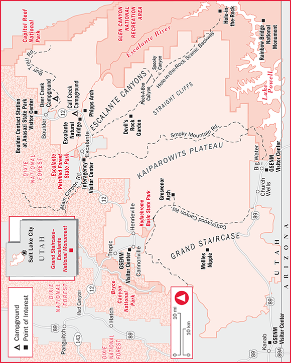
Getting There The national monument occupies a large section of southern Utah—covering an area almost as big as the states of Delaware and Rhode Island combined—with Bryce Canyon National Park to the west, Capitol Reef National Park on the northeast edge, and Glen Canyon National Recreation Area along the east and part of the south sides.
Access is via Utah 12 along the monument’s northern boundary, from Kodachrome Basin State Park and the communities of Escalante and Boulder, and via U.S. 89 to the southwestern section of the monument, east of the town of Kanab, which is about 80 miles south of Bryce Canyon.
Information/Visitor Centers The national monument remains a very rugged area, with limited facilities, poor roads, and changeable weather. Before setting out, all visitors are strongly urged to contact one of the monument’s visitor centers to get maps and other information, and especially to check on current road and weather conditions. Also see the monument’s website, www.ut.blm.gov/monument.
Visitor centers include the Escalante Interagency Visitor Center, on the west side of Escalante, at 755 W. Main St. (Utah 12), Escalante, UT 84726 ( 435/826-5499), open daily 8am to 4:30pm from mid-March through mid-November, and Monday through Friday the same hours the rest of the year. You can also get information at the Bureau of Land Management’s Kanab Visitor Center, 745 E. U.S. 89, Kanab, UT 84741 ( 435/644-4680), open daily 8am to 4:30pm.
The Cannonville Visitor Center is open daily from 8am to 4:30pm, mid-March through mid-November only, at 10 Center St., in Cannonville ( 435/826-5640), east of Bryce Canyon National Park. The Big Water Visitor Center is along U.S. 89, near the southern edge of Glen Canyon National Recreation Area, at 100 Upper Revolution Way, in Big Water ( 435/675-3200). It is open daily from 9am to 5:30pm April through October and daily 8am to 4:30pm the rest of the year.
Fees, Regulations & Safety There is no charge to enter the monument; those planning overnight trips into the backcountry should obtain free permits at any of the offices listed above. Regulations are similar to those on other public lands; damaging or disturbing archaeological and historic sites in any way is forbidden.
Water is the main safety concern here, whether there’s too little or too much. This is generally very dry country, so those going into the monument should carry plenty of drinking water. However, thunderstorms can turn the monument’s dirt roads into impassable mud bogs in minutes, stranding motorists, and potentially fatal flash floods through narrow canyons can catch hikers by surprise. Anyone planning trips into the monument should always check first with one of the offices listed above for current and anticipated weather and travel conditions.
Impressions
On this remarkable site, God’s handiwork is everywhere.
—Former President Bill Clinton, September 18, 1996
Outdoor Pursuits
This rugged national monument offers numerous opportunities for outdoor adventures, including canyoneering through narrow slot canyons with the aid of ropes. You can get information on the best areas for canyoneering at the monument’s visitor centers, but this is definitely not the place for beginners. To put it bluntly, people die here, and you don’t want to be one of them.
Unless you are an expert at this specialized sport, go with an expert. One of the best is Rick Green, owner of Excursions of Escalante ★★, 125 E. Main St., Escalante ( 800/839-7567; www.excursionsofescalante.com). Trips, which are available mid-March through mid-November, usually include four people with one guide, and all equipment is provided. In addition to canyoneering trips, the company offers day hiking and backpacking excursions, specialized tours, and 3-day canyoneering courses ($500–$600). Day trips include lunch. Day hiking trips cost $125 per person, canyoneering costs $145 to $165 per person, and a photo safari costs $170 per person. Overnight backpacking trips cost $250 to $275 per person per day, which includes practically everything you need, including food. Credit cards are not accepted; cash and checks are welcome. Excursions of Escalante also provides a flexible shuttle service; call for a quote.
Hiking, Mountain Biking & Horseback Riding Located about 15 miles northeast of Escalante via Utah 12, the Calf Creek Recreation Area has a campground, a picnic area with fire grates and tables, trees, drinking water, and flush toilets. The tree-shaded picnic and camping area lies along the creek at the bottom of a high-walled, rather narrow rock canyon. The best part of the recreation area, though, is the moderately strenuous 6-mile round-trip hike to Lower Calf Creek Falls. A sandy trail leads along Calf Creek, past beaver ponds and wetlands, to a beautiful waterfall that cascades 126 feet down a rock wall into a tree-shaded pool. You can pick up an interpretive brochure at the trail head. Day use fee is $2 per vehicle.
Although the Calf Creek Trail is the monument’s only officially marked and maintained trail, numerous unmarked cross-country routes are ideal for hiking, mountain biking (on existing dirt roads only), and horseback riding. Hikers are advised to stop at one of the visitor centers to get recommendations on hiking routes and to purchase topographic maps. Hikers need to remember that this is wild country and can be hazardous. Rangers recommend carrying at least 1 gallon of water per person per day and testing all water from streams before drinking. The potential for flooding is high, and hikers should check with the BLM before attempting to hike through the monument’s narrow slot canyons, which offer no escape during flash floods. Other hazards include poisonous snakes and scorpions and, in the wetter areas, poison ivy. Slickrock, as the name suggests, is slippery, so hikers should wear sturdy hiking boots with traction soles.
Among the popular and relatively easy-to-follow hiking routes is the footpath to Escalante Natural Bridge; it repeatedly crosses the river, so be prepared to get wet up to your knees. The easy 2-mile (one-way) hike begins at a parking area at the bridge that crosses the Escalante River near Calf Creek Recreation Area, 15 miles northeast of the town of Escalante. From the parking area, hike upstream to Escalante Natural Bridge, on the south side of the river. The bridge is 130 feet high and spans 100 feet.
Also starting at the bridge parking area is a hike downstream to Phipps Wash. Mostly moderate, this hike goes about 1.5 miles to the mouth of Phipps Wash, which enters the river from the west. You’ll find Maverick Natural Bridge in a north side drainage, and climbing up the drainage on the south side leads to Phipps Arch.
Hiking the national monument’s slot canyons is very popular, but the importance of checking on flood potentials before starting out cannot be stressed enough. A sudden rainstorm miles away can cause a flash flood through one of the monument’s narrow canyons, trapping hikers.
One challenging and very strenuous slot-canyon hike is through Peek-a-boo and Spooky canyons, which are accessible from the Hole-in-the-Rock Scenic Backway (see “Sightseeing & Four-Wheeling,” below). Stop at the Escalante Interagency Office for precise directions.
Sightseeing & Four-Wheeling Because this is one of America’s least-developed large sections of public land, it offers a wonderful opportunity for exploration by the adventurous. Be aware, though, that the dirt roads inside the monument turn muddy—and impassable—when it rains.
One particularly popular road is the Hole-in-the-Rock Scenic Backway, which is partly in the national monument and partly in the adjacent Glen Canyon National Recreation Area. Like most roads in the monument, this should be attempted in dry weather only. Starting about 5 miles northeast of Escalante off Utah 12, this clearly marked dirt road travels 57 miles (one-way) to the Hole-in-the-Rock. This is where Mormon settlers, in 1880, cut a passage through solid rock to get their wagons down a 1,200-foot cliff to the canyon floor and Colorado River below.
About 12 miles in, the road passes by the sign to Devil’s Rock Garden, which has classic red-rock formations and arches and a picnic area (about a mile off the main road). The road continues across a plateau of typical desert terrain, ending at a spectacular scenic overlook of Lake Powell. The first 35 miles of the scenic byway are relatively easy (in dry weather); it then gets a bit steeper and sandier, and the last 6 miles of the road require a high-clearance 4×4 vehicle. Allow about 6 hours round-trip, and make sure you have plenty of fuel and water.
Another recommended drive in the national monument is the Cottonwood Canyon Road, which runs from Kodachrome Basin State Park south to U.S. 89, along the monument’s southern edge, a distance of about 46 miles. The road is sandy and narrow and washboard in places, but it’s usually passable for passenger cars in dry weather. It mostly follows Cottonwood Wash, with good views of red-rock formations and distant panoramas from hilltops. About 10 miles east of Kodachrome Basin State Park is a short side road to Grosvenor Arch. This magnificent stone arch, with an opening 99 feet wide, was named for the National Geographic Society founder and editor, Gilbert H. Grosvenor, and is well worth the trip.
Wildlife Viewing & Birding The isolated and rugged terrain here makes a good habitat for a number of species, including desert bighorn sheep and mountain lions. More than 200 species of birds have been seen, including bald eagles, golden eagles, Swainson’s hawks, and peregrine falcons. The best areas for seeing wildlife are along the Escalante and Paria rivers and Johnson Creek.
Camping
Backcountry camping is permitted in most areas of the monument with a free permit, available at the Interagency Office in Escalante and BLM office in Kanab. Sites are first-come, first-served.
The monument also has two designated campgrounds. Calf Creek Campground, in the Calf Creek Recreation Area about 15 miles northeast of the town of Escalante via Utah 12, has 14 sites and a picnic area. Open year-round, the tree-shaded campground is situated in a steep, scenic canyon along Calf Creek, surrounded by high rock walls. There is an interpretive hiking trail, and facilities include flush toilets and drinking water, but no showers, RV hookups, RV dump stations, or trash removal. In summer, the campground is often full by 10am. From November through March, the water is turned off and only vault toilets are available. Vehicles must ford a shallow creek, and the campground is not recommended for vehicles over 25 feet long. Campsites cost $7 per night; day use is $2 per vehicle.
The national monument’s other designated campground is Deer Creek, located 6 miles east of the town of Boulder along the scenic Burr Trail Road. There are vault toilets, picnic tables, and grills, but no drinking water or other facilities. Camping at the seven primitive sites costs $4, and the campground is open year-round. RVs and cars can fit onto the sites here.
Rock or Wood—What Is This Stuff?
It looks like a weathered, multicolored tree limb, shining and sparkling in the light—but it’s heavy, hard, and solid as a rock. Just what is this stuff? It’s petrified wood.
Back in the old days—some 135 to 155 million years ago—southern Utah was not at all like you see it today. It was closer to the equator than it is now, which made it a wet and hot land, with lots of ferns, palm trees, and conifers providing lunch for the neighborhood dinosaurs.
Occasionally, floods would uproot the trees, dumping them in flood plains and along sandbars, and then bury them with mud and silt. If this happened quickly, the layers of mud and silt would cut off the oxygen supply, halting the process of decomposition—and effectively preserving the tree trunks intact.
Later, volcanic ash covered the area, and groundwater rich in silicon dioxide and other chemicals and minerals made its way down to the ancient trees. With the silicon dioxide acting as a glue, the cells of the wood mineralized. Other waterborne minerals produced the colors: Iron painted the tree trunks in reds, browns, and yellows; manganese produced purples and blues.
Sometime afterward, uplift from within the earth, along with various forms of erosion, brought the now-petrified wood to the surface in places like Escalante Petrified Forest State Park and Grand Staircase–Escalante National Monument, breaking it into the shapes of today in the process—one that’s taken only a hundred million years or so to complete.
Escalante Petrified Forest State Park
Large chunks of colorful petrified wood decorate this unique park, which offers hiking, fishing, boating, camping, and panoramic vistas of the surrounding countryside. There’s wildlife to watch, trails to hike, and a 30-acre reservoir for boating, fishing, and somewhat chilly swimming. It’s open all year, but spring through fall is the best time to visit. Hikers should be prepared for hot summer days and carry plenty of water.
Essentials
Getting There The park is 44 miles from Bryce Canyon. It’s located about 2 miles southwest of Escalante on Utah 12 at Wide Hollow Road.
Information/Visitor Center Contact Escalante Petrified Forest State Park, 710 N. Reservoir Rd., Escalante, UT 84726 ( 435/826-4466; www.stateparks.utah.gov). The visitor center, open daily, displays petrified wood, dinosaur bones, and fossils, plus an exhibit explaining how petrified wood is formed.
Fees & Regulations Entry costs $6 per vehicle, which includes boat launching. As at most parks, regulations are generally based on common sense and courtesy: Don’t damage anything, drive slowly on park roads, and observe quiet hours between 10pm and 7am. In addition, you’re asked to resist the temptation to carry off samples of petrified wood. Pets are welcome, even on trails, but must be on leashes no more than 6 feet long.
Outdoor Pursuits
Fishing & Boating Wide Hollow Reservoir, located partially inside the park, has a boat ramp (sorry, no rentals are available) and is a popular fishing hole for rainbow trout and bluegill, plus ice-fishing in winter.
Hiking The 1-mile loop Petrified Forest Trail ★ is a moderately strenuous hike among colorful rocks, through a forest of stunted juniper and piñon pine, past a painted desert, to a field of colorful petrified wood. The hike also offers panoramic vistas of the town of Escalante and surrounding stair-step plateaus. A free brochure is available at the visitor center. Allow about 45 minutes. An optional three-quarter-mile loop off the main trail—called Trail of Sleeping Rainbows—leads through a large mound of petrified wood, but is considerably steeper than the main trail.
Wildlife-Watching This is one of the best spots in the region to see wildlife ★. The reservoir is home to ducks, geese, and coots. Chukar partridges wander throughout the park, and you’re also likely to see eagles, hawks, lizards, ground squirrels, and both cottontails and jackrabbits. Binoculars are helpful.
Camping
The 22-unit RV and tent campground, within easy walking distance of the park’s hiking trails and reservoir, is open year-round. Facilities include hot showers, modern restrooms, and drinking water. There are four sites with water and electric RV hookups. Camping costs $16 per night, $20 with hookups. Reservations are available at 800/322-3770 or 801/322-3770 (www.reserveamerica.com); an $8 nonrefundable fee will be charged.
Basing Yourself in Escalante
Originally called Potato Valley, this community’s name was changed in the 19th century to honor Spanish explorer and missionary Father Silvestre Velez de Escalante. But it’s believed Escalante never actually visited this particular part of southern Utah on his trek from Santa Fe, New Mexico, to California, a hundred years earlier. Home to nearly 100 historic buildings (a free walking-tour map is available at the information booth and at local businesses), Escalante is your best bet for lodging, food, and supplies as you travel Utah 12. At 5,868 feet elevation, it’s also a good base for exploring the nearby mountains and Grand Staircase–Escalante National Monument, or for finally taking a hot shower after a week of backpacking. Be aware, though: Services in this town of 800 are limited in winter.
Essentials
Getting There Escalante is 50 miles east of Bryce Canyon National Park and 63 miles south of Capitol Reef National Park on the Highway 12 Scenic Byway. Utah 12 becomes Main Street as it goes through town.
Visitor Information The National Park Service, Dixie National Forest, and Bureau of Land Management operate the Escalante Interagency Visitor Center that provides recreation and other tourist information year-round. It’s located on the west side of Escalante, at 755 W. Main St. (Utah 12), Escalante, UT 84726 ( 435/826-5499), and open daily 8am to 4:30pm from mid-March through mid-November, and Monday through Friday the same hours the rest of the year.
The Escalante Chamber of Commerce, P.O. Box 175, Escalante, UT 84726 ( 435/826-4810; www.escalante-cc.com), can also provide area information.
What to See & Do
Several local companies will help you explore this rugged land. Excursions of Escalante offers guided day and overnight trips in Grand Staircase–Escalante National Monument and the nearby national forest. Escalante Outfitters (see “Where to Stay,” below), offers guided fly-fishing trips in the national monument and on Boulder Mountain. Cost for a full-day trip, including lunch and all gear, is $225 for one angler, $275 for two, and $300 for three. Escalante Outfitters also leads evening natural history hikes ($45 per person), and has a well-stocked store where you’ll find outdoor clothing, maps, guide books, and whatever outdoor gear you might need.
But the great outdoors isn’t the only reason to visit Escalante. Art lovers should schedule their visits for late September or early October, when Escalante and nearby communities join to sponsor the Escalante Canyons Arts Festival–Everett Ruess Days, with demonstrations, workshops, contests, exhibits, talks, music, and more. Subjects range from painting to pottery, plus quilting, ceramics, tie-dying, cowboy poetry—you name it.
The festival is named for Everett Ruess, a young artist who disappeared in the rugged canyon country near here in November 1934 and whose remains were recently discovered. For additional information on the festival and on Ruess, contact the chamber of commerce (see above), or check out the festival website, www.everettruessdays.org.
As a small town, Escalante has a surprising number of galleries and working artists. Pick up a free copy of the brochure Escalante Arts & Crafts Guide, which includes a map, at the Escalante Interagency Visitor Center (see “Visitor Information,” above), or check out the chamber of commerce website, www.escalante-cc.com.
A Fascinating Gallery/Shop
Philip and Harriet Priska’s Serenidad Gallery, 360 W. Main St. ( 888/826-4577 or 435/826-4720; www.serenidadgallery.com), offers seven rooms crammed with wild and wonderfully fun stuff. Browse among fine art, photography, antiques, collectibles, gift items, jewelry, and even locally handmade soaps and lip balms. Petrified wood and local rocks fill one room. Harriet’s huge collection of buttons includes her own hand-painted porcelain creations. The Priskas carry only things they particularly like, so it’s fun to talk with them about the selection of items. The gallery/shop is open daily from 8:30am to 8:30pm, with occasional meal breaks.
Where to Stay
Room tax adds about 11%. Pets are not accepted unless otherwise noted.
In addition to the lodging choices discussed below, the Shooting Star Drive-In, 2020 W. Utah 12, Escalante ( 435/826-4440; www.shootingstardrive-in.com), offers a unique opportunity to spend the night in a luxurious, custom-designed Airstream trailer, decorated as they might have been when movie stars had such accommodations while filming on location. There are eight Airstreams, each with a fully equipped kitchen and full bathroom, and all the amenities you would expect as the Hollywood star you obviously are. There’s a drive-in theater—open to lodging guests only—where you sit in a vintage convertible to watch the latest from Cary Grant, Clark Gable, or Marilyn Monroe. Rates range from $149 to $169 double. There is also an Airstream-only RV park with 18 sites ($30–$40).
For additional information on lodging, including house rentals, contact the chamber of commerce (see above).
Escalante Outfitters These cute little log cabins are a favorite of backpackers who want a break from sleeping on the ground. Think of this place as a cross between a motel and a campground; actually, it’s closer to the auto camps of the 1930s. Built in the mid-1990s, each cabin either has one queen-size bed or a pair of bunk beds, a chair, a small table with a lamp, and two small windows. There’s heat in cool weather and fans for warm weather. That’s it. All guests share a simple but adequate and well-maintained bathhouse; no private bathrooms are available. On the grounds are barbecue pits, picnic tables, and horseshoe pits. There is also a camping area for about 10 tents ($16 per night). A state liquor store and outdoor gear and clothing store are on the premises.
310 W. Main St. (Utah 12), P.O. Box 575, Escalante, UT 84726. www.escalanteoutfitters.com. 866/455-0041 or 435/826-4266. 7 units. $45 double. AE, DISC, MC, V. Dogs accepted for a $10 per night fee. Closed Nov–Feb. Amenities: Restaurant (Esca-Latte Internet Café & Pizza Parlor; see below). In room: No phone, Wi-Fi (free).
Escalante’s Grand Staircase Bed & Breakfast Inn This beautiful B&B has spacious rooms with skylights, full private bathrooms, and beds with pillow-top mattresses. The modern country decor includes some furniture in solid wood aspen or lodgepole pine, Southwestern drum tables, and pictograph designs on the walls. The full gourmet breakfast consists of a fruit dish, juice, coffee, tea, and hot chocolate, and a main course including breakfast meats or breads. Food allergies can be accommodated with advance notice. The entire property, including the grounds, is nonsmoking.
280 W. Main St. (Utah 12), Escalante, UT 84726. www.escalantebnb.com. 866/826-4890 or 435/826-4890. 8 units. Mid-Mar to Oct from $145 double; Nov–Feb from $110 double. DISC, MC, V. Children 11 and under not accepted; older children accepted with prior approval. In room: A/C, TV, hair dryer, Wi-Fi (free).
Where to Eat
Pizza lovers should stop at the Esca-Latte Internet Café & Pizza Parlor, located in Escalante Outfitters, 310 W. Main St. ( 866/455-0041 or 435/826-4266; www.escalanteoutfitters.com). This is the place for true aficionados, where you can build your own 12- or 16-inch pizza by selecting among some 20 toppings, ranging from pepperoni to Utah goat cheese. It also has a salad bar, a variety of hot and cold coffee drinks, and Utah microbrew beer. Most lunch and dinner main courses cost from $8.50 to $13; most breakfast items range from $5.50 to $7.50. The restaurant is open daily from 8am to 9pm, and is usually closed from November through February.
For excellent burgers, including a black bean burger, and slow-smoked locally raised range-fed beef, stop at Circle D Eatery, 475 W. Main St., Escalante ( 435/826-4125; www.escalantecircledeatery.com). House specialties at dinner include brisket, the steak of the day, smoked chicken, and pork ribs, or you can choose baked trout filet, a teriyaki veggie stir-fry, sandwiches, or spaghetti with homemade marinara sauce. Lunch is more burgers, sandwiches, and salads, and the breakfast menu includes egg dishes, pancakes, granola, and fruit. Hours are 7:30am to around 9:30pm daily (closed mid-Nov to early Feb). Prices for most main courses are $5 to $11 breakfast and lunch, and $7.50 to $19 dinner. Wine and an excellent selection of beer are served.
Excellent regional cuisine, prepared from organic and natural ingredients, is on the menu at Hell’s Backbone Grill ( 435/335-7464; www.hellsbackbonegrill.com), a classy but casual restaurant about 28 miles northeast of Escalante in the community of Boulder, at 20 N. Hwy. 12. It’s open 7 to 11:30am and 5 to 9:30pm daily from mid-March through late November; it’s closed the rest of the year. The menu changes seasonally, but for dinner you’re likely to be offered chipotle meatloaf with lemony mashed potatoes and vegetables from the restaurant’s own farm or skillet fried trout with blue corn, pecans, and molasses. Try to leave room for one of the yummy desserts such as the lemon chiffon cake or a chocolate chili cream pot. Breakfast items include a variety of egg dishes, French toast, homemade granola, and various breakfast meats. Dinner main courses are priced from $17 to $32, while breakfast items cost $6 to $13. Wine and beer are served.
North from Escalante Along Utah 12
Heading toward Capitol Reef National Park from the town of Escalante, the rugged mountain scenery, with forests of pine and fir producing a deep green contrast to the rosy red, orange, and brown hues of the region’s rock formations, comes into view.
Picturesque Posey Lake (sometimes spelled Posy), under the jurisdiction of the U.S. Forest Service, is open to nonmotorized boats and offers good fishing for rainbow trout. It’s in a mixed conifer forest at 8,600 feet elevation, some 16 miles northwest of Escalante via Utah 12 and gravel Forest Road 153. Facilities include a picnic area, two floating docks, fish cleaning stations, and a boat ramp. There are several trail heads, and numerous dirt roads are popular with mountain bikers and hikers in summer, cross-country skiers and snowmobilers in winter. The Posy Lake Campground, usually open mid-May through early September, has 20 sites (maximum RV length 24 ft.), drinking water, and restrooms, but no showers, RV hookups, or trash pickup. Camping costs $10 per night, and reservations are available ( 877/444-6777; www.recreation.gov) for an additional booking fee of $10. For information on the lake and campground, contact the Escalante Interagency Visitor Center (see “Visitor Information,” above).
Visitors to Anasazi State Park Museum, in the village of Boulder (about 28 miles northeast of Escalante along Utah 12), step back to the 12th century a.d., when the Kayenta Anasazi (also called Ancestral Puebloans) lived here in one of the largest communities west of the Colorado River. The 6-acre park includes the ruins of the village, a full-size six-room replica of a home, a gift shop, picnic area, auditorium, and museum. The museum is open daily from 8am to 6pm from April through October and Monday through Saturday from 9am to 5pm the rest of the year. It is closed Thanksgiving, Christmas, and New Year’s Day. Admission costs $5 per person, $3 for seniors 62 and older, with a $10 maximum per family. There is no campground. For more information, contact Anasazi State Park Museum, 460 N. Utah 12, Boulder, UT 84716 ( 435/335-7308; www.stateparks.utah.gov).
Boulder Mountain ★★ has some of the most dramatic views along Utah 12. Located northeast of Escalante at an elevation of 9,670 feet, you are practically in the clouds. From viewpoints such as Point Lookout, you’ll gaze out over the colorful sandstone rock cliffs of Capitol Reef National Park to the imposing Henry Mountains, Navajo Mountain, and sights more than 100 miles away.
Those venturing into the backcountry by foot, four-wheel-drive, mountain bike, or horse will discover rugged, remote beauty; the area is also a trout fisherman’s paradise, with dozens of secluded mountain lakes and streams hidden among the tall pines and firs. Escalante Outfitters offers guided fly-fishing trips. Don’t be surprised to see mule deer, elk, and wild turkey in the open meadows. Contact the Escalante Interagency Visitor Center (see “Visitor Information,” above) for information.
After Boulder, it’s not too much farther to Capitol Reef National Park, but first is the community of Torrey, where Utah 12 intersects with Utah 24. You can turn right here and proceed to the park. See chapter 12 for complete coverage of Capitol Reef.