Chapter 14: From Moab to Arches & Canyonlands National Parks
Canyonlands country they call this—a seemingly infinite high desert of rock, with spectacular formations and rugged gorges that have been carved over the centuries by the forces of the Colorado and Green rivers. Massive sandstone spires and arches that seem to defy gravity, all colored by iron and other minerals in shades of orange, red, and brown, define the national parks of southeastern Utah. This is a land that begs to be explored—if you’ve come to Utah for mountain biking, hiking, four-wheeling, or rafting, then this is the place. And the region holds a few surprises, too, from Ancestral Puebloan (also called Anasazi) dwellings and rock art to dinosaur bones.
Moab: Gateway to the National Parks
238 miles SE of Salt Lake City
Named for a biblical kingdom at the edge of Zion, the promised land, Moab has evolved into a popular base camp for mountain bikers, four-wheel-drive enthusiasts, hikers, kayakers, and rafters eager to explore the red-rock canyon country that dominates southeastern Utah. A drive down Main Street confirms that, yes, this is a tourist town, with scores of businesses catering to visitors.
Not far from the Colorado River, Moab sits in a green valley among striking red sandstone cliffs, a setting that has lured Hollywood filmmakers for hits such as John Wayne’s The Comancheros, the biblical epic The Greatest Story Ever Told, Indiana Jones and the Last Crusade, Thelma & Louise, and City Slickers II.
Southeast Utah
Like most Utah towns, Moab was established by Mormon pioneers sent by church leader Brigham Young. But Moab was actually founded twice. The first time, in 1855, missionaries set up Elk Mountain Mission to see to the spiritual needs of the local Ute. Apparently unimpressed with the notion of abandoning their own religion for the ways of the LDS Church, the Ute killed several missionaries, sending the rest back to Salt Lake City in a hurry. It wasn’t until 20 years later that the settlers tried again; this time, they successfully established a small farming and ranching community.
Moab (elevation 4,000 ft.) remains a relatively small town, with just under 5,000 permanent residents, but that still makes it the biggest community in southeastern Utah. Practically within walking distance of Arches National Park, Moab is also close to Canyonlands National Park and is surrounded by the Manti-La Sal National Forest and vast, open spaces under the jurisdiction of the Bureau of Land Management (BLM).
Essentials
Getting There Situated on U.S. 191, Moab is 30 miles south of I-70 (take exit 182 at Crescent Junction) and 53 miles north of Monticello. Moab is 399 miles northeast of the north rim of Grand Canyon National Park and 238 miles southeast of Salt Lake City. From Salt Lake City, follow I-15 south to Spanish Fork, take U.S. 6 southeast to I-70, and follow that east to Crescent Junction, where you’ll pick up U.S. 191 south to Moab.
Sixteen miles north of downtown Moab, Canyonlands Field ( 435/259-4849; www.moabairport.com) has daily scheduled flights between Moab and Denver and Moab and Las Vegas on Great Lakes Airlines ( 800/554-5111 or 435/259-0566; www.flygreatlakes.com) and car rentals from Enterprise ( 435/259-8505; www.enterprise.com). Shuttle service into Moab is also available from several companies, including Roadrunner Shuttle ( 435/259-9402; www.roadrunnershuttle.com).
The closest major airport is Grand Junction Regional Airport, about 112 miles east in Grand Junction, Colorado ( 970/244-9100; www.gjairport.com). It has direct flights or connections from most major cities on Allegiant, American/American Eagle, Continental, Delta, United, and US Airways. Car rentals are available at the airport from Alamo ( 970/243-3097; www.alamo.com), Avis ( 970/244-9170; www.avis.com), Budget ( 970/244-9170; www.budget.com), Enterprise ( 970/254-1700; www.enterprise.com), Hertz ( 970/243-0747; www.hertz.com), and National ( 970/243-6626; www.nationalcar.com).
Another option for air travelers is to fly into Salt Lake City International Airport ( 800/595-2442 or 801/575-2400; www.slcairport.com), about 240 miles from Moab, which has service from most major airlines and rental-car companies. You can rent a car at the airport and drive to Moab, or check with Roadrunner Shuttle ( 435/259-9402; www.roadrunnershuttle.com) or Moab Luxury Coach ( 435/940-4212; www.moabluxurycoach.com) about current shuttle rates and schedules.
Amtrak’s ( 800/872-7245; www.amtrak.com) California Zephyr stops in Green River, about 52 miles north of Moab, and provides service to Salt Lake City and Grand Junction, Colorado. If you plan to go from Green River to Moab, make reservations with Roadrunner Shuttle or Moab Luxury Coach (see above).
Visitor Information For area information, contact the Moab Area Travel Council, P.O. Box 550, Moab, UT 84532 ( 800/635-6622 or 435/259-8825; www.discovermoab.com). When you arrive, stop by the Moab Information Center, at the corner of Main and Center streets, open Monday through Saturday 8am to 8pm and Sunday from 9am to 7pm from mid-March through October, with shorter hours the rest of the year. This multiagency visitor center has information from the Park Service, Bureau of Land Management, U.S. Forest Service, Grand County Travel Council, and Canyonlands Natural History Association. You can get advice, watch a number of videos on Southwest attractions, pick up brochures on local businesses and outfitters, and purchase books, videos, and other materials. A board displays current weather conditions and campsite availability.
Getting Around Rentals (standard passenger cars, vans, and four-wheel-drive vehicles) are available from Enterprise ( 435/259-8505; www.enterprise.com). Rugged four-wheel-drive vehicles are available from Farabee’s Jeep Rentals ( 877/970-5337 or 435/259-7494; www.farabeejeeprentals.com); Canyonlands Jeep Adventures ( 866/892-5337 or 435/259-4413; www.canyonlandsjeep.com), which also rents regular passenger cars; and Cliffhanger Jeep Rental ( 435/259-0889; www.cliffhangerjeeprental.com), which also rents camping trailers. Want a cab? Call Moab Taxi ( 435/210-4297).
Fast Facts The full-service Moab Regional Hospital, 450 Williams Way ( 435/259-7191; www.amhmoab.org), offers 24-hour emergency care. The post office is at 50 E. 100 North ( 800/275-8777; www.usps.com).
The best grocery store in town is City Market, 425 S. Main St. ( 435/259-5181; www.citymarket.com), open daily from 6am to 11pm. Pick up sandwiches from the deli, mix it up at the excellent salad bar, or choose fresh-baked items from the bakery before hitting the trail. The store also sells fishing licenses, money orders, and stamps; offers photo finishing; and has a pharmacy.
Outdoor Pursuits
The Moab area is one of Utah’s main outdoor playgrounds, an ideal spot for hiking, boating, camping, or just plain horsing around (with or without the horse). In addition to the nearby national parks, Arches and Canyonlands, which are covered in full later in this chapter, there’s plenty of room to roam on land administered by the Bureau of Land Management’s Moab office, 82 E. Dogwood Ave., Moab, UT 84532 ( 435/259-2100; www.blm.gov/utah/moab), and the Manti-La Sal National Forest’s Moab Ranger District, 62 E. 100 North (P.O. Box 386), Moab, UT 84532 ( 435/259-7155; www.fs.fed.us/r4). The best source for information is the Moab Information Center.
Because of the extreme desert heat in summer, the best time for most outdoor activities is spring or fall—even the relatively mild winters are inviting. If you end up vacationing in the middle of summer, do your serious hiking and mountain biking early in the day, enjoy a siesta along the river or beside a swimming pool during the heat of the afternoon, and take a short hike in the evening, just before sundown.
Outfitters
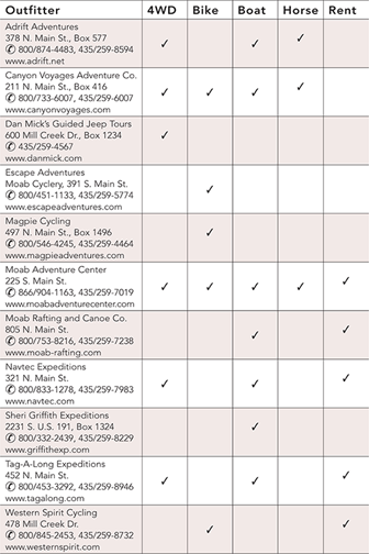
Although Moab has plenty for the do-it-yourselfer, more than 60 local outfitters offer guided excursions of all kinds, from lazy canoe rides to hair-raising jet-boat and four-wheel-drive adventures. The chart below lists some of the major companies that can help you fully enjoy this beautiful country, and you can get additional recommendations at the Moab Information Center. All are located in Moab. Advance reservations are often required. It’s best to check with several outfitters before deciding on one; in addition to asking about what you’ll see and do and what it costs, it doesn’t hurt to make sure the company is insured and has the proper permits with the various federal agencies. Also ask about its cancellation policy, just in case.
 A Desert Oasis
For a delightful escape from the desert heat, take a break at the Scott M. Matheson Wetlands Preserve ★, 934 W. Kane Creek Blvd. ( 435/259-4629; www.nature.org/wherewework). Owned by the Nature Conservancy, this lush oasis attracts more than 200 species of birds and other wildlife, such as river otters, beavers, and muskrats. The preserve has a wheelchair-accessible 1-mile loop trail, boardwalks over the wet areas, and a two-story viewing blind. Guided bird walks are given (call for the current schedule), and bird and wildlife lists and self-guided tour brochures are available. In late spring and summer, visitors are advised to bring mosquito repellent. The preserve is open daily year-round from dawn to dusk, and admission is free. From downtown Moab, go south on Main Street to Kane Creek Boulevard (btw. McDonald’s and Burger King), and go west about 3⁄4 mile, passing the Moab Public Works Department, to a Y in the road. Take the left fork, and continue for about another half-mile to the preserve entrance. From the parking area, a footpath and bridge lead over Mill Creek to an information kiosk and into the preserve.
Four-Wheeling
The Moab area has thousands of miles of four-wheel-drive roads, most left over from mining days. These roads offer a popular way to explore this scenic country without exerting too much energy.
A number of local companies (see “Outfitters,” above) provide guided trips, starting at about $70 per adult and $60 per child under 16 or 17 for a half-day. You can also rent a 4×4 and take off on your own (see “Getting Around,” above).
When hitting the trail on your own, either in a rental or personal 4×4, you will encounter everything from fairly easy dirt roads to “You-don’t-really-expect-me-to-take-this-$50,000-SUV-up-there-do-you?” piles of rocks. Several four-wheel-drive trips are described in the Canyonlands section, later in this chapter, and a free brochure, available at the Moab Information Center, covers several others.
Poison Spider Mesa Trail ★★★, which covers 16 miles of 4×4 road, providing stupendous views down to the Colorado River and Moab Valley, is a favorite of four-wheelers. It’s considered difficult; a short-wheelbase high-clearance vehicle is best. Allow at least 4 hours. To reach the trail from the Moab Information Center, drive north on U.S. 191 for about 6 miles and turn west (left) onto Utah 279. Continue another 6 miles to the dinosaur tracks sign, where the trail leaves the pavement to the right, passing over a cattle guard. From here, simply follow the main trail (which is usually obvious) up switchbacks, through a sandy canyon, and over some steep, rocky stretches. From a slickrock parking area on top, you can take a short walk to Little Arch, which isn’t really so little.
One easy 4×4 road is the Gemini Bridges Trail, which four-wheelers share with mountain bikers (see below). Those with 4×4s often drive the route in the opposite direction of the mountain bikers, starting at a dirt road departing from the west side of U.S. 191, about 10 miles north of the Moab Information Center. This involves more uphill driving, which is safer for motor vehicles—mountain bikers usually prefer going downhill.
The self-guided Mill Canyon Dinosaur Trail provides a close-up view of dinosaur bones and fossils from the Jurassic period, including a sauropod leg bone, vertebrae, ribs, toe bones, and the fossil remains of a large tree trunk. To reach the trail head, drive about 15 miles north of Moab on U.S. 191, then turn left at an intersection just north of highway mile marker 141. Cross the railroad tracks and follow a dirt road for about 2 miles to the trail head. Allow about 1 hour. On the south side of the canyon are the remnants of an old copper mill that operated in the late 1800s. Also nearby are the ruins of the Halfway Stage Station, a lunch stop in the late 1800s for stagecoach travelers making the 35-mile trip between Moab and Thompson, the nearest train station at that time. From the dinosaur trail head, go north as though you’re returning to U.S. 191, but at the first intersection, turn right and drive to a dry wash, where you turn right again onto a jeep road that takes you a short distance to the stage station. The trail is managed by the BLM’s Moab office.
Golfing
It might be hard to keep your eye on the ball at the 18-hole, par-72 Moab Golf Club course, 2705 East Bench Rd. ( 435/259-6488; www.moabcountryclub.com). Located 5 miles south of downtown Moab in Spanish Valley (take Spanish Trail Rd. off U.S. 191), the challenging course, nestled among red sandstone cliffs, offers spectacular views in every direction. Open daily year-round (weather permitting), the course has a driving range, a pro shop and lessons, and a snack bar open for breakfast and lunch. Greens fee is $42, which includes cart rental.
Hiking
The Moab area offers hundreds of hiking possibilities, many of them just a few miles from town. Get information at the Moab Information Center and pick up the free brochure that describes seven local trails. Hikes in nearby Arches and Canyonlands national parks are described later in this chapter.
Particularly in the summer, carry at least a gallon of water per person per day and wear a broad-brimmed hat.
A local favorite is the Negro Bill Canyon Trail, named for William Granstaff, who lived in the area in the late 1800s. Allow about 4 hours for this 4-mile-plus round-trip hike, which is considered easy to moderate. You may get your feet wet, depending on the level of the stream you follow up the canyon. To get to the trail head, go north from Moab on U.S. 191 to Utah 128, turn east (right), and go about 3 miles to a dirt parking area. A little over 2 miles up the trail, in a side canyon to the right, is the Morning Glory Bridge, a natural rock span of 243 feet. Watch out for the poison ivy that grows by a pool under the bridge. (In case you don’t remember from your scouting manual, poison ivy has shiny leaves with serrated edges, and grows in clusters of three.)
The Hidden Valley Trail is a bit more challenging, taking you up a series of steep switchbacks to views of rock formations and a panorama of the Moab Valley. Allow at least 3 hours for the 4-mile round-trip. To get to the trail head, drive about 3 miles south of the Moab Information Center on U.S. 191, turn west (right) onto Angel Rock Road, and go 2 blocks to Rimrock Road. Turn north (right) and follow Rimrock Road to the parking area. The trail is named for a broad shelf, located about halfway up the Moab Rim. Many hikers turn around and head back down after reaching a low pass with great views of huge sandstone fins (the 2-mile point), but you can extend the hike by continuing all the way to the Colorado River on a four-wheel-drive road.
The highly recommended Corona Arch Trail offers views of three impressive arches, a colorful slickrock canyon, and the Colorado River. Allow 2 hours for this 3-mile round-trip hike, which involves a lot of fairly easy walking plus some rather steep spots with handrails and a short ladder. From Moab, go north on U.S. 191 to Utah 279, turn west (left), and go about 10 miles to a parking area on the north side of the road. A registration box and trail head are near the railroad; after crossing the tracks, follow an old roadbed onto the trail, which is marked with cairns (piles of stones).
Horseback Riding
For those who want to see the canyons from horseback, several companies lead guided rides (get current information from the Moab Information Center), and one company, Adrift Adventures, offers combination rafting/horseback riding excursions, starting at $109 each for adults, $99 each for children 8 to 17 (see “Outfitters,” above).
Mountain Biking
With hundreds and hundreds of miles of trails, a wide variety of terrains, and spectacular scenery, Moab is easily the mountain-bike capital of Utah, and possibly of the United States. In addition to the mountain-biking possibilities on four-wheel-drive roads in the national parks (see sections on Arches and Canyonlands national parks, later in this chapter), there are abundant trails on Bureau of Land Management and national forest lands that are much less trafficked than national park routes.
When you get into town, stop by the Moab Information Center for a free copy of the Moab Area Mountain Bike Trails pamphlet. Discuss your plans with the very knowledgeable employees here, who can help you find the trails most suitable for your interests, ability, and equipment. You can also get information, as well as rent or repair bikes, at Poison Spider Bicycles, 497 N. Main St. ( 800/635-1792 or 435/259-7882; www.poisonspiderbicycles.com), which recommends shuttle services from Porcupine Shuttle ( 435/260-0896). Bike rentals and repairs, plus shuttle services, will be found at Chile Pepper Bike Shop, 702 S. Main St. ( 888/677-4688 or 435/259-4688; www.chilebikes.com). Bike rentals range from $40 to $65 per day, with discounts for multiday rentals. Bike shuttle services are also available from several other companies, including Coyote Shuttle ( 435/260-2097; www.coyoteshuttle.com) and Roadrunner Shuttle ( 435/259-9402; www.roadrunnershuttle.com).
Several local companies (see “Outfitters,” above) also offer guided mountain-bike tours, with rates starting at about $85 for a half-day and about $110 for a full day. Multiday biking/camping trips are also available.
The area’s most famous trail is undoubtedly the Slickrock Bike Trail ★★★, a scenic but challenging 11-mile loop that crosses a mesa of heavily eroded pale orange Navajo sandstone just a few minutes from downtown Moab. Along the way, the trail offers views that take in the towering La Sal Mountains, the red-rock formations of Arches National Park, a panorama of Canyonlands National Park, and the Colorado River. The trail, open to both mountain bikes and motorcycles, is physically demanding and technically difficult and not recommended for children, novices, or anyone who is out of shape or has medical problems. Allow 4 to 5 hours, and expect to walk your bike in some areas. If you’re not sure you’re ready for the trail, get started on the 2 1/4-mile practice loop. To access the trail head from the visitor information center, take Center Street east to 400 East. Turn south (right) and follow 400 East to Mill Creek Drive. Turn east (left) and follow Mill Creek Drive to Sand Flats Road, which you take 2 1/3 miles east to the BLM’s Sand Flats Recreation Area and the trail head.
Those looking for a somewhat less challenging experience might try the Gemini Bridges Trail, a 14-mile one-way trip that shows off the area’s colorful rock formations, including the trail’s namesake: two natural rock bridges. Considered relatively easy, this trail follows a dirt road mostly downhill, ending at U.S. 191 just under 10 miles from the center of Moab, so it’s best to arrange a shuttle (see above). To get to the trail head from the Moab Information Center, drive north along U.S. 191 to Utah 313, turn west (left), and go about 13 miles. Allow a full day, including getting to and from the trail, and be sure to watch for the magnificent view of Arches National Park from a hilltop as you approach U.S. 191 near the end of the ride.
Although dozens of fabulous trails are waiting for you to explore in the immediate area, mountain bikers who really want to go somewhere—perhaps all the way to Colorado—will want to check out Kokopelli’s Trail and the San Juan Hut System. Winding for 142 miles across sandstone and shale canyons, deserts, and mountains, Kokopelli’s Trail connects Moab and Grand Junction, Colorado. It combines all types of mountain biking, from demanding single track to well-maintained dirt roads, and passes primitive campsites along the way. The elevation change is about 4,200 feet. The west end of the trail is near Sand Flats Road in Moab; the east end is at the Loma Boat Launch, 15 miles west of Grand Junction. For more information contact the Colorado Plateau Mountain Bike Trail Association, P.O. Box 4602, Grand Junction, CO 81502 ( 970/244-8877; www.copmoba.org).
The San Juan Hut Systems, P.O. Box 773, Ridgway, CO 81432 ( 970/626-3033; www.sanjuanhuts.com), links Moab with Telluride and Durango, both in Colorado, via two 215-mile mountain-bike trail systems. Approximately every 35 miles there is a primitive cabin with eight bunks, a woodstove, a propane cooking stove, cooking gear, and groceries. The route is appropriate for intermediate-level mountain-bikers in good physical condition; more experienced cyclists will find advanced technical single tracks near the huts. The mountain-biking season generally runs from June through September. The cost for riders who plan to make either complete trip is $850 per person, which includes use of the six huts, food, sleeping bags at each hut, and maps and trail descriptions. Shorter trips and shuttles are also available.
Rock Climbing
Those with the proper skills and equipment for rock climbing will find ample opportunities in the Moab area; check with the BLM. Several companies also offer instruction and guided climbs, with rates for full-day climbs generally from $150 to $200 per adult with two people going. Contact Desert Highlights, 50 E. Center St., Moab ( 800/747-1342 or 435/259-4433; www.deserthighlights.com), Moab Desert Adventures, 415 N. Main St., Moab ( 877/765-6622 or 435/260-2404; www.moabdesertadventures.com), or Moab Cliffs & Canyons, 253 N. Main St., Moab ( 877/641-5271 or 435/259-3317; www.cliffsandcanyons.com). For climbing equipment, you’ll find one of the best selections anywhere, at reasonable prices, at Gearheads, 471 S. Main St. ( 435/259-4327), which also offers free filtered water (bring your own jugs).
Watersports: Boating, Canoeing, Rafting & More
After spending hours in the blazing sun looking at mile upon mile of huge red sandstone rock formations, it’s easy to get the idea that the Moab area is a baking, dry, rock-hard desert. Well, it is. But Moab is also the only town in Utah that sits along the Colorado River ★★, and it’s rapidly becoming a major boating center.
You can travel down the river, all the way down to Canyonlands National Park, in a canoe, kayak, large or small rubber raft (with or without motor), or a speedy, solid jet boat. Do-it-yourselfers can rent kayaks or canoes for $40 to $65 for a full day, or rafts starting at $70 for a full day. Half-day guided river trips start at about $45 per person; full-day trips are usually $55 to $75 per person. Multiday rafting expeditions, which include meals and camping equipment, start at about $300 per person for 2 days. Jet-boat trips cost about $50 for 2 hours, and from $80 for a half-day trip. Children’s rates are usually 10% to 20% lower. Some companies also offer sunset or dinner trips. See “Outfitters.”
Public boat-launching ramps are opposite Lion’s Park, near the intersection of U.S. 191 and Utah 128; at Take-Out Beach, along Utah 128 about 10 miles east of its intersection with U.S. 191; and at Hittle Bottom, also along Utah 128, about 24 miles east of its intersection with U.S. 191. For recorded information on river flows and reservoir conditions statewide, contact the Colorado Basin River Forecast Center ( 801/539-1311; www.cbrfc.noaa.gov).
What to See & Do
Film Museum at Red Cliffs Lodge Moab, and much of this part of Utah, has been a popular location for moviemaking since it was “discovered” by famed director John Ford. Ford filmed much of Stagecoach, starring a young John Wayne, in Monument Valley in the 1930s; in the 1940s, Ford found Moab. The Red Cliffs Ranch provided the spectacular scenery for many of Ford’s movies, including Wagon Master and Rio Grande. In recent years, feature films shot in the Moab area have included City Slickers and Thelma & Louise. The museum has exhibits from the earliest films to the most recent, including props, posters, and photos—and the scenery’s still spectacular. Allow 1 hour.
Red Cliffs Lodge, 14 miles east of Moab on Utah 128 (milepost 14).  866/812-2002 or 435/259-2002. www.redcliffslodge.com/museum. Free admission. Daily 8am–10pm.
Museum of Moab This growing museum, which is also known as the Dan O’Laurie Museum of Moab, has numerous displays depicting the history of Moab from prehistoric times to the present. It starts with dinosaur skeletons and bones and also has exhibits on the geology of the area and the resultant uranium and radium mining. A hands-on testing area allows for identification of minerals. The archaeology section includes a large basket unearthed near Moab plus Ancestral Puebloan and early Fremont pottery. You can try your hand (actually your feet) at the restored player piano. Early home-medical remedies are on display, as is the first incubator, which used only a 25-watt bulb and was invented by a local doctor. There is a large hand-carved relief map of the Moab area, as well as the expected ranching and farming exhibits. Another display discusses the National Park Service, Bureau of Land Management, and U.S. Forest Service, describing their role in the area—a large one—and how they work together. Allow about an hour.
118 E. Center St. (2 blocks east of Main St.). 435/259-7985. www.moabmuseum.org. Admission $5 for those 17 and older, free for youths 16 and under, $10 family. Mar–Oct Mon–Fri 10am–5pm, Sat noon–5pm; Nov–Feb Mon–Sat noon–5pm. Closed Thanksgiving, Christmas, and New Year’s Day.
Where to Stay
Room rates are generally highest from March through October—with the highest rates often in September—and sometimes drop by up to half in winter. High season rates are listed here; call or check websites for off-season rates. A room tax of 12.25% is added to all bills. Pets are not accepted unless otherwise noted.
Most visitors are here for the outdoors and don’t plan to spend much time in their rooms; as a result, many book into one of the fully adequate chain and franchise motels, most of which are located on Main Street. Franchises here include our favorite, the very well-maintained but a bit pricey La Quinta Inn, 815 S. Main St. ( 435/259-8700; www.lq.com), which is pet friendly and charges from $169 double. Other more-than-adequate franchises, with rates in the same general area, include Super 8, on the north edge of Moab at 889 N. Main St. ( 435/259-8868; www.super8.com), Best Western Plus Canyonlands Inn, 16 S. Main St. ( 435/259-2300; www.bestwesternutah.com), Best Western Plus Greenwell Inn, 105 S. Main St. ( 435/259-6151; www.bestwesternutah.com), and Comfort Suites, 800 S. Main St. ( 435/259-5252; www.choicehotels.com). You’ll generally find lower rates at Days Inn, 426 N. Main St. ( 435/259-4468; www.daysinn.com), Motel 6, 1089 N. Main St. ( 435/259-6686; www.motel6.com), and Sleep Inn, 1051 S. Main St. ( 435/259-4655; http://moabsleepinn.com). Alternatives include the cabins at Arch View Resort RV Camp Park, Canyonlands Campground & RV Park, and Moab Valley RV Resort (see “Camping,” below).
Big Horn Lodge Spacious rooms with log furniture and knotty pine walls give the Big Horn a lodgelike atmosphere. All of the well-maintained units have two queen-size beds. Bikes are permitted in the rooms. All units are nonsmoking.
550 S. Main St., Moab, UT 84532. www.moabbighorn.com. 800/325-6171 or 435/259-6171. Fax 435/259-6144. 58 units. $90–$120 double. AE, DISC, MC, V. Pets permitted with $5 per-night fee. Amenities: Restaurant; Jacuzzi; outdoor heated pool. In room: A/C, TV, fridge, hair dryer, Internet (free).
Bowen Motel This older family-owned-and-operated motel offers fairly large, comfortable, clean, basic rooms with attractive wallpaper and a king-size or one or two queen-size beds. Family units sleep up to six persons each, and there is an 1,800-square-foot guest house with three bedrooms, two full bathrooms, and a complete kitchen (about $300 per night). All units are nonsmoking.
169 N. Main St., Moab, UT 84532. www.bowenmotel.com. 800/874-5439 or 435/259-7132. Fax 435/259-6641. 40 units. $84–$109 double. Rates include continental breakfast. AE, DC, DISC, MC, V. Pets accepted with $10 per-night fee. Amenities: Heated outdoor pool. In room: A/C, TV, fridge (some), Wi-Fi (free).
Cali Cochitta Bed & Breakfast ★★ For a delightful escape from the hustle and bustle of Moab, head to the Cali Cochitta (Aztec for “House of Dreams”), a handsomely restored late-1800s Victorian home, with great views of the surrounding mountains and red rock formations. The spacious guest rooms have queen-size beds with down comforters, handsome wood furnishings (including many antiques), and cotton robes. Our favorite room is the romantic Cane, which has a high queen-size mahogany sleigh bed and French glass doors. The cottages have refrigerators, and the suite can be rented as one or two rooms. Breakfasts include a hot entree (often prepared with herbs from the inn’s garden), plus fresh muffins or other baked goods, fruit, and beverages. Bike storage is available. All units are smoke-free.
110 S. 200 E., Moab, UT 84532. www.moabdreaminn.com. 888/429-8112 or 435/259-4961. Fax 435/259-4964. 6 units. Mar–Oct $135–$175 double; Nov–Feb $90–$140 double. Rates include full breakfast. DISC, MC, V. Amenities: Heated outdoor pool. In room: A/C, TV, fridge (some), hair dryer, no phone, Wi-Fi (free).
Lazy Lizard International Hostel This hostel offers exceptionally clean, comfortable lodging at bargain rates on the south side of town. The main house, which is air-conditioned, has basic dorm rooms plus two private rooms. A separate building contains four private rooms, which look much like older motel units. The best facilities are the cabins, constructed of real logs, with beds for up to six. There’s also a camping area (no hookups). Everyone shares the bathhouses and the phone in the main house. Guests also have use of a fully equipped kitchen; living room with TV, VCR, and movies; gas barbecue grill; and picnic tables. Groups should inquire about the nearby houses, which can be rented by the night ($120–$260 for 12–30 people).
1213 S. U.S. 191, Moab, UT 84532. www.lazylizardhostel.com. 435/259-6057. 25 dorm beds, 10 private rooms, 8 cabins; total capacity 65 persons. $10 dorm bed; $29 private room double occupancy; $33 cabin double occupancy; $7 per person camping space. Showers $3 for nonguests. Hostel membership not necessary. AE, DISC, MC, V, but cash preferred. In room: A/C, no phone.
Red Stone Inn  This centrally located motel is comfortable and quiet and offers quite a bit for the price. The exterior gives the impression that these are cabins, and the theme continues inside, with log furniture and colorful posters and maps of area attractions decorating the knotty pine walls. Rooms are a bit on the small side, although perfectly adequate and spotlessly maintained. Three rooms accessible to travelers with disabilities have combination tub/showers. There is a mountain bike work stand and bike wash, and bikes are permitted in the rooms. On-site is a covered picnic area with tables and gas barbecue grills, and guests have free access to the heated outdoor pool at a sister motel across the street.
535 S. Main St., Moab, UT 84532. www.moabredstone.com. 800/772-1972 or 435/259-3500. Fax 435/259-2717. 52 units. $90–$99 double. AE, DISC, MC, V. Pets accepted ($5 fee). Amenities: Indoor Jacuzzi; access to heated outdoor pool. In room: A/C, TV, fridge, hair dryer, Internet (free).
Sunflower Hill Luxury Inn ★★★ This upscale country-style retreat, 3 blocks off Main Street, is an excellent choice for a relaxing escape. The elegant rooms are individually decorated—for instance, the Summer House Suite boasts a colorful garden-themed mural—with handmade quilts on the queen-size beds, and bathrobes and Molton Brown toiletries. Deluxe rooms have jetted tubs and private balconies. The popular French Bedroom includes a hand-carved antique bedroom set, stained-glass window, vaulted ceiling, white lace curtains, and large whirlpool tub and separate tiled shower. The lush grounds are grassy and shady, with fruit trees and flowers and a delightful swimming pool, all lending it the air of an oasis. There is locked bike storage, a swing, a picnic table, and a barbecue. The substantial breakfast buffet includes fresh-baked breads and pastries, honey-almond granola, fresh fruit, and a hot entree such as a vegetable frittata, Belgian waffles, or potato omelet. All units are nonsmoking.
185 N. 300 East, Moab, UT 84532. www.sunflowerhill.com. 800/662-2786 or 435/259-2974. Fax 435/259-3065. 12 units. Mid-Mar to Oct $169–$239 double; Nov to mid-Mar $120–$180 double. Rates include full breakfast and evening refreshments. AE, DISC, MC, V. Children 9 and under are generally not allowed. Amenities: Jacuzzi; outdoor heated pool. In room: A/C, TV, DVD/VCR player, CD player, hair dryer, no phone, Wi-Fi (free).
Camping
In addition to the commercial campgrounds discussed here, you can also camp at Canyonlands and Arches national parks, at Dead Horse Point State Park, and at Newspaper Rock, which are discussed elsewhere in this chapter. Pets are permitted in campgrounds unless otherwise noted. Those camping on public lands where there are no showers can get a list of businesses offering public showers from the Moab Area Travel Council’s website (www.discovermoab.com; “Area Info & Services” section) or at the Moab Information Center. The cost runs from $2.25 to $8.
Arch View Resort RV Camp Park This well-maintained campground offers all the usual RV hookups, showers, and other amenities you’d expect in a first-class commercial RV park, plus great views into Arches National Park, especially at sunset. Located about 6 miles from the park entrance, Arch View has trees throughout the park, a grassy tent area, a convenience store, a pool, a playground, a coin-op laundry, Wi-Fi, and propane, gasoline, and diesel sales. Basic log cabins and more upscale, fully equipped cottages are available for $50 and up for two people.
U.S. 191, at the junction with U.S. 313, 9 miles north of town (P.O. Box 938), Moab, UT 84532. www.archviewresort.com. 800/813-6622 or 435/259-7854. 83 sites. For 2 people, $23 tent, $35–$45 RV. AE, DISC, MC, V. Closed mid-Nov to mid-Mar.
Canyonlands Campground ★ This campground is surprisingly shady and quiet, given its convenient downtown location, which makes it our top choice for a commercial campground here. Open year-round, it has tent sites as well as partial and full (including cable TV) RV hookups. Facilities include a dump station, self-service laundry, convenience store, playground, and outdoor heated pool. It also offers Wi-Fi. There are also six cabins ($58 double). A City Market grocery store is within walking distance.
555 S. Main St., Moab, UT 84532. www.canyonlandsrv.com. 800/522-6848 or 435/259-6848. 122 sites. For 2 people, $25–$29 tent, $35–$39 RV. AE, DISC, MC, V. Dogs not permitted in cabins.
Moab Valley RV Resort Situated on the north side of Moab, near the intersection of U.S. 191 and Utah 128, this campground is just 2 miles from Arches National Park. Practically any size RV can be accommodated in the extra-large pull-through sites, and some tent sites are covered. All sites have great views of the surrounding rock formations. There are trees and patches of grass, and full RV hookups include cable TV connections. Facilities include an RV dump station, coin-op laundry, convenience store, bike wash, outdoor pool and whirlpool tub, a playground, and Wi-Fi. Eighteen cabins and cottages are available starting at $55 for two people.
1773 N. U.S. 191, Moab, UT 84532. www.moabvalleyrv.com. 435/259-4469. 115 sites. For 2 people, $24 tent, $31–$45 RV. MC, V. Closed Nov–Feb. Dogs permitted in RV sites, but not in tent sites or cabins.
Where to Eat
In addition to the restaurants discussed here, Moab has a 24-hour Denny’s at 191 N. U.S. 191 ( 435/259-8839; www.dennys.com). Also, see the Bar-M Chuckwagon and Canyonlands by Night & Day, under “Moab After Dark,” below. To view the menus of practically every restaurant in town, see www.moabhappenings.com.
Buck’s Grill House ★★ AMERICAN WESTERN Among Moab’s best choices for steak, this popular restaurant also does a lot of other things well. The dining room’s subdued Western decor is accented by exposed wood beams and local artwork, and there are two patios—one open air and one heated and covered. There’s also a bar, the Vista Lounge. Especially good are the grilled sirloin or New York strip; the buffalo meatloaf, with black onion gravy; and the slow-cooked elk stew. Southwestern dishes include duck tamale with grilled pineapple salsa, and the ground chuck or bison burgers are an especially good deal at $10. Pasta and vegetarian items are also served. Buck’s offers full liquor service and a good wine list and serves a variety of Utah microbrews.
1393 N. U.S. 191, about 1 1/2 miles north of town. 435/259-5201. www.bucksgrillhouse.com. Main courses $9–$38. DISC, MC, V. Daily 5:30pm–closing.
Eddie McStiff’s AMERICAN This bustling, noisy brewpub is half family restaurant and half bar, with a climate-controlled garden patio bar as well. The dining room has a Southwest decor, and the bar has the look of an Old West saloon—long bar, low light, and lots of wood. You can’t beat the fresh-ground burgers here—beef, buffalo, salmon, turkey, and veggie—but the menu also includes a good variety of grill items, pasta, and excellent pizzas. Specialties include grilled Atlantic salmon and slow-smoked barbecued ribs, and prime rib is available after 4:30pm. About a dozen fresh-brewed beers are on tap, and full liquor service is available.
In McStiff’s Plaza, 57 S. Main St. (just south of the information center). 435/259-2337. www.eddiemcstiffs.com. Main courses $8–$19. DISC, MC, V. Daily 11:30am–midnight.
Moab Brewery ★ ECLECTIC Fresh ales brewed on-site, along with a wide variety of steaks, sandwiches, salads, soups, vegetarian dishes, and assorted house specialties, are served at this open, spacious microbrewery and restaurant on the south side of town. It’s popular with families, who gobble down basic American fare such as half-pound burgers; fresh fish, including good salmon tacos; and, our top choice here, the St. Louis smoked pork ribs. The huge dining room is decorated with light woods, outdoor sports equipment—including a hang glider on the ceiling—and local artwork. Patio dining is available. You can sample the brews—from wheat ale to oatmeal stout—at the separate bar. Aside from the wares in the gift shop, you can also purchase beer-to-go in half-gallon jugs. Beer is sold in the bar; in the restaurant, diners can purchase beer, wine, or mixed drinks.
686 S. Main St. 435/259-6333. www.themoabbrewery.com. Main courses $7–$22. AE, DISC, MC, V. Sun–Thurs 11:30am–10:30pm; Fri–Sat 11:30am–11:30pm.
Moab Diner & Ice Cream Shoppe ★  AMERICAN/SOUTHWESTERN Late risers can get breakfast—about the best in town—all day here, featuring the usual egg dishes, biscuits and gravy, and a spicy breakfast burrito. Hamburgers, sandwiches, and salads are the offerings at lunch. For dinner, it’s steak, shrimp, and chicken, plus liver and onions. The green chili is excellent. In addition to ice cream, you can get malts and shakes, plus sundaes with seven different toppings. The decor is old-time diner, with comfy red vinyl booths, a bit of neon, photos of classic cars, and old Coca-Cola ads. No alcoholic beverages are served.
189 S. Main St. 435/259-4006. www.moabdiner.com. Main courses $5.75–$11 breakfast and lunch, $7.25–$15 dinner. MC, V. Mon–Sat 6am–10pm. Closed New Year’s, Thanksgiving, and Christmas.
Sunset Grill ★★ AMERICAN Perched on a hill at the north edge of Moab, this fine restaurant offers the best sunset views in town. Once the home of uranium miner Charles Steen, the Sunset Grill contains four tastefully decorated dining rooms and three patios. A favorite of locals celebrating special events, the restaurant serves excellent steaks, hand-cut in-house, plus such treats as a roasted half duck with a raspberry sauce, and a grilled salmon filet with an Asian glaze served in a light soy-sherry cream sauce. Texas-style prime rib sells out often, so get here early if it’s your first choice. The menu also includes a number of chicken dishes and several pasta selections. Full liquor service is available.
900 N. U.S. 191. 435/259-7146. www.sunsetgrillmoab.com. Main courses $14–$26. AE, DISC, MC, V. Mon–Sat 5pm–closing.
Moab After Dark
For a small town in conservative, nondrinking Utah, this is a pretty wild place. After a day on the river or in the back of a jeep, don’t be surprised to see your outfitter letting his or her hair down at Eddie McStiff’s, a microbrewery that’s part family restaurant and part bar, with several TVs and a game room with pool tables, foosball, shuffleboard, and, if you must, Wi-Fi. Another good option for beer lovers is the Moab Brewery. The Rio Sports Bar & Grill, 2 S. 100 West, a block west of Main Street on Center Street ( 435/259-6666), is a longtime locals’ favorite watering hole known for its large selection of alcoholic beverages. For a relaxing, somewhat sophisticated and more upscale bar, stop at Vista Lounge, located inside Buck’s Grill House .
Those looking for a foot-stompin’ good time and a Western-style dinner will want to make their way to the Bar-M Chuckwagon Live Western Show and Cowboy Supper, 7 miles north of Moab on U.S. 191 ( 800/214-2085 or 435/259-2276; www.barmchuckwagon.com). Diners go through a supper line to pick up sliced roast beef or barbecued chicken, baked potatoes, baked pinto beans, cinnamon applesauce, buttermilk biscuits, cake, and nonalcoholic beverages. Vegetarian meals can be prepared with advance notice, and beer and wine coolers are available. After dinner, a stage show entertains with Western-style music, jokes, and down-home silliness from the Bar-M Wranglers. The grounds, which include a small Western village and gift shop, open at 6:30pm, with gunfights starting at 7pm, dinner at 7:30pm, and the show following supper. The Bar-M is usually open from April through mid-October, but is closed several evenings each week; call for the current schedule. Supper and the show cost $28 for adults, $14 for children 4 to 12, and free for kids 3 and younger. Reservations are strongly recommended.
Canyonlands by Night & Day ( 800/394-9978 or 435/259-5261; www.canyonlandsbynight.com) offers a variety of excursions in the area, including an evening river trip, operating spring through fall, that combines a 1 1/2-hour sunset jet-boat ride with a Dutch-oven dinner. Cost for the boat trip and dinner is $70 for adults and $60 for children 4 to 12 (minimum age 4), with a family rate of $215 for two adults and two children. A 4-hour daytime jet-boat ride costs $80 for adults and $70 for children 4 to 12 (minimum age 4), with a family rate for two adults and two kids of $249. Reservations are recommended. The office and dock are just north of Moab at the Colorado River Bridge.
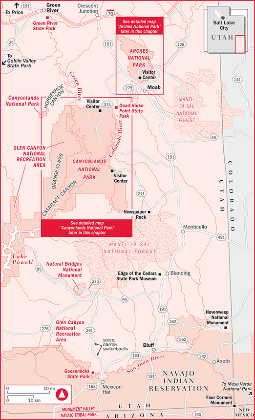
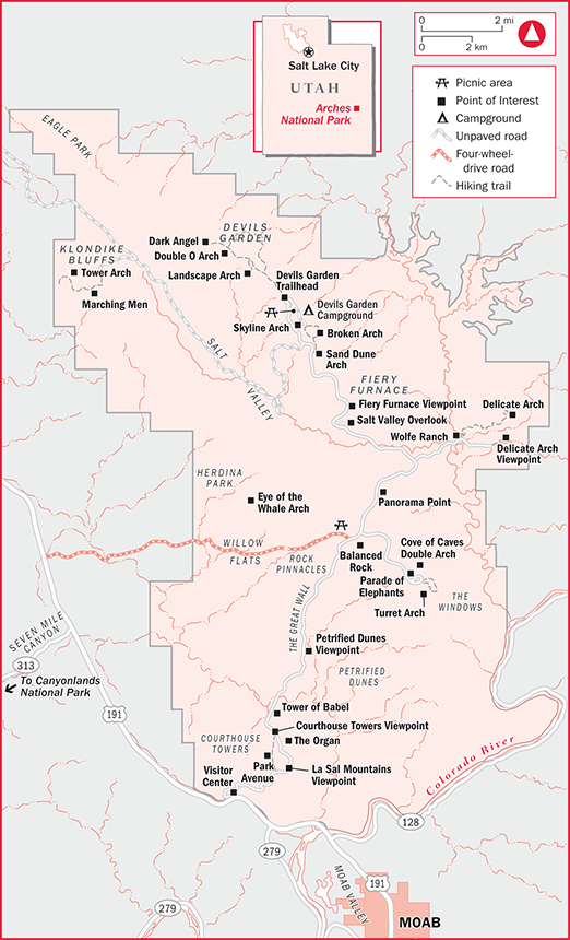
Arches National Park ★★
233 miles SE of Salt Lake City
Natural stone arches and fantastic rock formations are the defining features of this park, and they exist in remarkable numbers and variety. Just as soon as you’ve seen the most beautiful, most colorful, most gigantic stone arch you can imagine, walk around the next bend and there’s another—bigger, better, and more brilliant than the last. It would take forever to see them all, with more than 2,000 officially listed and more being discovered or “born” every day.
Arches National Park
Some people think of arches as bridges, but to geologists there’s a big difference. Bridges are formed when a river slowly bores through solid rock. The often bizarre and beautiful contours of arches result from the erosive force of rain and snow, which freezes and thaws, dissolving the “glue” that holds the sand grains together and chipping away at the stone, until gravity finally pulls a chunk off.
Although arches usually grow slowly—very slowly—something dramatic happens every once in a while: like that quiet day in 1940 when a sudden crash instantly doubled the size of the opening of Skyline Arch, leaving a huge boulder lying in its shadow. Luckily, no one (that we know of) was standing underneath it at the time. The same thing happened to the magnificently delicate Landscape Arch in 1991, when a slab of rock about 60 feet long, 11 feet wide, and 4 1/2 feet thick fell from the underside of the arch. Now there’s such a thin ribbon of stone that it’s hard to believe it can continue standing at all.
Spend a day or a week here, exploring the terrain, watching the rainbow of colors deepen and explode with the long rays of the setting sun, and gazing at the moonlight glistening on the tall sandstone cliffs. Watch for mule deer, cottontail rabbits, and bright green collared lizards as they go about the difficult task of desert living. And let your own imagination run wild among the Three Gossips, the Spectacles, the Eye of the Whale, the Penguins, the Tower of Babel, and the thousands of other statues, towers, arches, and bridges that await your discovery in this magical playground.
Essentials
See the Moab section of this chapter for camping options outside the park, plus lodging, restaurants, and other nearby services.
Getting There From Moab, drive 5 miles north on U.S. 191. Arches is located 27 miles east of Canyonlands National Park’s Island in the Sky Visitor Center, 233 miles southeast of Salt Lake City, 404 miles northeast of the north rim of Grand Canyon National Park in Arizona, and 371 miles west of Denver, Colorado.
Information/Visitor Centers For advance information, contact Arches National Park, P.O. Box 907, Moab, UT 84532 ( 435/719-2299; www.nps.gov/arch).
Books, maps, and videos on Arches as well as Canyonlands National Park and other southern Utah attractions can be purchased from the nonprofit Canyonlands Natural History Association, 3015 S. U.S. 191, Moab, UT 84532 ( 800/840-8978 or 435/259-6003; www.cnha.org). Some publications are available in foreign languages.
The attractive Arches National Park Visitor Center is just inside the entrance gate. It offers maps, brochures, and other information, and a museum explains arch formation and other features of the park. Be sure to take time to watch the orientation film, Secrets of Red Rock, shown in the auditorium. From April through October the visitor center is open daily from 7:30am to 6:30pm; the rest of the year it’s open daily 8am to 4:30pm. On Christmas Day, the park is open but the visitor center is closed.
Fees, Regulations & Backcountry Permits Entry for up to 7 days costs $10 per private vehicle or $5 per person on foot, motorcycle, or bike. A $25 annual pass is also available; it’s good for Arches and Canyonlands national parks as well as Natural Bridges and Hovenweep national monuments. Campsites cost $20 per night, and guided ranger walks into Fiery Furnace cost $10 for adults and $5 for children 5 to 12. Required permits for overnight trips into the backcountry, available at the visitor center, are free.
Backcountry hikers should practice minimum-impact techniques, packing out all trash. Feeding or otherwise disturbing wildlife is prohibited, as is vandalizing or disturbing any natural, cultural, or historic feature of the park. Wood fires are not permitted. Dogs, which must be leashed at all times, are prohibited in public buildings, on all trails, and in the backcountry.
Seasons/Avoiding the Crowds Summer days here are hot, often exceeding 100°F (38°C), and winters can be cool or cold, dropping below freezing at night, with snow possible. The best time to visit, especially for hikers, is in spring or fall, when daytime temperatures are usually between 60° and 80°F (16°–27°C) and nights are cool.
Visitation to Arches is highest from March through October, with August the peak month. Parking lots are crowded and the campground is often full by late morning. As with most popular parks, avoid visiting during school vacations if possible.
Ranger Programs From spring through fall, rangers lead guided hikes on the Fiery Furnace Trail (see “Outdoor Pursuits,” below), as well as daily nature walks at various park locations. Evening campfire programs, also from spring through fall, are held on topics such as rock art, geological processes, and wildlife. A schedule of events is posted at the visitor center.
Kids between the ages of 6 and 12 can pick up a Junior Ranger booklet at the visitor center. After completing activities and participating in several programs, kids pick up their badge and certificate at the visitor center.
Seeing the Park’s Highlights by Car
Arches is the easiest of Utah’s national parks to see in a day, if that’s all you can spare. An 18-mile (one-way) scenic drive offers splendid views of countless natural rock arches and other formations, and several easy hikes reveal additional scenery. Allow 1 1/2 hours for the round-trip drive, adding time for optional hikes.
You can see many of the park’s most famous rock formations without even getting out of your car—although venturing out and exploring on foot is always the best way to see them. You have the option of walking short distances to a number of viewpoints, or stretching your legs on a variety of longer hikes along the way (see “Outdoor Pursuits,” below). The main road is easy to navigate, even for RVs, but parking at some viewpoints is limited. Please be considerate and leave trailers at the visitor center parking lot or in a Moab campground.
Start out by viewing the short slide show at the visitor center to get a feel for what lies ahead. Then drive north past the Moab Fault to the overlook parking for Park Avenue, a solid rock “fin” that reminded early visitors of the New York skyline.
From here, your next stop is La Sal Mountain Viewpoint, where you look southeast to the La Sal Mountains, named by early Spanish explorers who thought the snow-covered mountains looked like huge piles of salt. In the overlook area is a “desert scrub” ecosystem, composed of sagebrush, saltbush, blackbrush, yucca, and prickly pear cactus. Animals that inhabit the area include the kangaroo rat, black-tailed jackrabbit, rock squirrel, several species of lizards, and the coyote.
Continuing on the scenic drive, some of the park’s major formations will come into view: At Courthouse Towers, large monoliths, such as Sheep Rock, the Organ, and the Three Gossips, dominate the landscape. Leaving Courthouse Towers, watch for the Tower of Babel on the east (right) side of the road, then proceed past the petrified sand dunes to Balanced Rock, a huge boulder weighing about 3,600 tons, perched on a slowly eroding pedestal. You can take an easy, .3-mile round-trip walk around the base of the pedestal from the Balanced Rock parking area. You get a great close-up view of the huge and precariously perched rock.
Continuing, take a side road to the east (right) to the Windows. Created when erosion penetrated a sandstone fin, they can be seen after a short walk from the parking area. Also in this area are Turret Arch and the Cove of Caves. Erosion is continuing to wear away at the back of the largest cave, which means it will probably become an arch one day. The North and South Windows are also off this trail. Once you reach them, take the loop around back and see for yourself why they are sometimes called Spectacles—the scene looks almost like a sea monster poking its large snout up into the air. A short walk from the parking lot takes you to Double Arch, which looks exactly like what its name implies. It is possible to climb right up underneath the arch; just take care not to disturb the delicate desert vegetation. To the right of Double Arch are several alcoves that may one day become arches. If you’re visiting in the spring, look for the sego lily, Utah’s state flower. It has three lovely cream-colored petals with a reddish-purple spot fading to yellow at the base. From the end of this trail, you can also see the delightful Parade of Elephants.
Return to the main park road, turn north (right) and drive to Panorama Point, which offers an expansive view of Salt Valley and the Fiery Furnace, which can really live up to its name at sunset.
Next, turn east (right) off the main road onto the Wolfe Ranch Road and drive to the Wolfe Ranch parking area. A very short walk leads to what’s left of this ranch. John Wesley Wolfe and his son Fred moved here from Ohio in 1898, and, in 1907, were joined by John’s daughter Flora, her husband, and their children. The cabin seen here was built for Flora’s family (John’s cabin was destroyed by a flash flood). In 1910, the family decided this was not the greatest location for a ranch, and they packed up and returned to Ohio. If you follow the trail a bit farther, you’ll see some Ute petroglyphs.
More ambitious hikers can continue for a moderately difficult 3-mile round-trip excursion to Delicate Arch, with a spectacular view at trail’s end. If you don’t want to take the hike, you can still see this lovely arch, albeit from a distance, by getting back in your car, continuing down the road for 1 mile, and walking a short trail (about a 5-min. walk) to the Delicate Arch Viewpoint.
Returning to the park’s main road, turn north (right) and go to the next stop, the Salt Valley Overlook. The various shades of color in this collapsed salt dome are caused by differing amounts of iron in the rock, among other factors.
Continue to the vantage point for Fiery Furnace, which offers a dramatic view of colorful sandstone fins. This is where 3-hour ranger-guided hikes begin.
From here, drive to a pullout for Sand Dune Arch, located down a short path from the road, where you’ll find shade and sand along with the arch. This is a good place for kids to play. The trail leads across a meadow to Broken Arch (which isn’t broken at all—it just looks that way from a distance).
Back on the road, continue to Skyline Arch, whose opening doubled in size in 1940 when a huge boulder tumbled out of it. The next and final stop is the often crowded parking area for the Devils Garden Trailhead. From here, you can hike to some of the most unique arches in the park, including Landscape Arch, which is among the longest natural rock spans in the world. It’s a pretty easy 1.6-mile round-trip hike.
From the trail head parking lot, it’s 18 miles back to the visitor center.
Outdoor Pursuits
Biking Bikes are prohibited on all trails and are not allowed to travel cross-country within national park boundaries. The park’s established scenic drive is open to cyclists, although you need to be aware that the 18-mile dead-end road is narrow and winding in spots and can be a bit crowded with motor vehicles in summer.
Mountain bikers also have the option of tackling one of several four-wheel-drive roads (see below). For guided mountain-bike trips outside the park, as well as rentals, repairs, and supplies, see the Moab section earlier in this chapter.
Four-Wheeling Arches doesn’t have nearly as many four-wheel-drive opportunities as nearby Canyonlands National Park, but it has a few, including the Salt Valley Road and the Willow Flats Road, both of which can be extremely slick after a rain and are open to four-wheel-drive vehicles and mountain bikes. Check at the visitor center for directions and current conditions.
Hiking Most trails here are short and relatively easy, although because of the hot summer sun and lack of shade, it’s wise to carry a good amount of water on any jaunt of more than 1 hour.
One easy walk is to Sand Dune Arch, a good place to take kids who want to play in the sand. It’s only .3 miles (round-trip), but you can add an extra 1.2 miles by continuing on to Broken Arch. Sand Dune Arch is hidden among and shaded by rock walls, with a naturally created giant sandbox below the arch. Resist the temptation to climb onto the arch and jump down into the sand: Not only is it dangerous, but it can also damage the arch. Those who continue to Broken Arch should watch for mule deer and kit foxes, which inhabit the grassland you’ll be crossing. Allow about 30 minutes to Sand Dune Arch and back; 1 hour to Broken Arch.
From the Devils Garden Trail, you can see about 15 to 20 arches on a strenuous and difficult hike of 7.2 miles round-trip, or view some exciting scenery by following only part of the route. Take at least the easy-to-moderate 1.6-mile round-trip hike to Landscape Arch ★, a long, thin ribbon of stone that’s one of the most beautiful arches in the park. Watch for mule deer along the way, and allow about an hour. Past Landscape Arch, the trail becomes more challenging but offers numerous additional views, including panoramas of the curious Double O Arch and a large, dark tower known as Dark Angel. From the section of the trail where Dark Angel is visible, you are 2.5 miles from the trail head. If you turn back at this point, the round-trip will take about 3 hours; if you keep going, you’ll have the primitive loop almost to yourself as most people turn back at Double O Arch.
The park’s best and most scenic hike, the 3-mile round-trip Delicate Arch Trail ★★, is a moderate-to-difficult hike, with slippery slickrock, no shade, and some steep drop-offs along a narrow cliff. Hikers are rewarded with a dramatic and spectacular view of Delicate Arch, as well as a visit to the John Wesley Wolfe ranch, and an opportunity to take a side trip to a Ute petroglyph panel that includes what may represent a bighorn sheep hunt. When you get back on the main trail, watch for collared lizards—up to a foot long—which are usually bright green with stripes of yellow or rust, with a black collar. Collared lizards feed in the daytime, mostly on insects and other lizards, and can stand and run on their large hind feet in pursuit of prey. (Very reminiscent of Jurassic Park.)
Continuing along the trail, watch for Frame Arch, off to the right. Its main claim to fame is that numerous photographers have used it to “frame” a photo of Delicate Arch in the distance. Just past Frame Arch, the trail gets a little weird—narrow and twisting—having been blasted out from the cliff. Allow 2 to 3 hours.
The Fiery Furnace Guided Hike ★ is a strenuous 2-mile round-trip naturalist-led hike to some of the most colorful formations in the park. Guided hikes are given into this restricted area twice daily from March through October, by reservation. Cost is $10 per adult, $5 per child from 5 to 12. Children 5 to 13 must be accompanied by an adult, and children under 5 are not permitted. Reservations must be made at least 4 days in advance (no more than 6 months in advance) online at www.recreation.gov. As you hike along, a ranger describes the desert plants, points out hard-to-find arches, and discusses the geology and natural history of the Fiery Furnace. Rangers recommend against it, but you can hike in the Fiery Furnace on your own. You must first obtain a permit and watch a short video (get details at the visitor center). Other restrictions apply, and there are no marked trails, so it’s best to join a guided hike.
Another strenuous hike is to Tower Arch. This 3.4-mile round-trip hike on a primitive trail starts with a steep incline to the top of the bluff and proceeds up and down, with great views of the Klondike Bluffs to the right. Beware of the slickrock that makes up part of the trail, and watch for the cairns leading the way. The hardest part is near the end, where you struggle uphill through loose sand. Your reward is a grand sight: the immense Tower Arch standing among a maze of sandstone spires. Climb up under it for a soothing view while you take a much-deserved break. In the spring, the majestic, snowcapped La Sal Mountains can be seen to the east through the arch opening.
The backcountry has no trails or campsites, and very little of the park is open to overnight camping, but backcountry hiking is permitted. Ask park rangers to suggest routes. No fires are allowed, and hikers must carry their own water and practice low-impact hiking and camping techniques. Those planning to be out overnight need free backcountry permits, available at the visitor center.
Camping
Devils Garden Campground ★, at the north end of the park’s scenic drive, is Arches’ only developed camping area, offering a perfect location for exploring the park. The 50 well-spaced sites are nestled among rocks, with plenty of piñon and juniper trees, and some sites can accommodate RVs up to 30 feet long. From March through October, the campground accepts reservations ( 877/444-6777; www.recreation.gov), with a $9 additional booking fee. In summer, the campground fills very early, with people arriving early trying to garner any nonreserved sites, so reservations are strongly recommended. Sites costs $20 per night. You’ll find drinking water and flush toilets, but no showers or RV hookups. See the Moab section earlier in this chapter for information on public showers and nearby commercial campgrounds.
Canyonlands National Park ★★
34 miles W of Moab, 304 miles SE of Salt Lake City
Canyonlands National Park
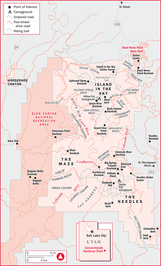
Utah’s largest national park is not for the sightseer out for a Sunday afternoon drive. Instead, it rewards those willing to spend time and energy—lots of energy—exploring the rugged backcountry. Sliced into districts by the Colorado and Green rivers, which are the park’s primary architects, this is a land of extremes: vast panoramas, dizzyingly deep canyons, dramatically steep cliffs, broad mesas, and towering red spires.
The most accessible part of Canyonlands is the Island in the Sky District, in the northern section of the park, where a paved road leads to sites such as Grand View Point, which overlooks some 10,000 square miles of rugged wilderness. Island in the Sky has several easy-to-moderate trails offering sweeping vistas. A short walk provides views of Upheaval Dome, which resembles a large volcanic crater but may actually have been created by the crash of a meteorite. For the more adventurous, the 100-mile White Rim Road takes experienced mountain bikers and those with high-clearance four-wheel-drive vehicles on a winding loop tour through a vast array of scenery.
The Needles District, in the southeast corner, offers only a few viewpoints along the paved road, but boasts numerous possibilities for serious hikers and backpackers, and those with high-clearance 4×4s or mountain bikes. Named for its tall, red-and-white-striped rock pinnacles, this diverse district is home to impressive arches, including the 150-foot-tall Angel Arch, as well as grassy meadows and the confluence of the Green and Colorado rivers. Backcountry visitors will also find ruins and rock art left by the Ancestral Puebloans (also known as Anasazi) some 800 years ago.
Most park visitors don’t get a close-up view of the Maze District, but instead see it off in the distance from Grand View Point at Island in the Sky or Confluence Overlook in the Needles District. That’s because it’s inhospitable and practically inaccessible. A lot of endurance and at least several days are necessary to see even a few of its sites, such as the appropriately named Lizard Rock and Beehive Arch. Hardy hikers can visit Horseshoe Canyon in 1 day, where they can see the Great Gallery, an 80-foot-long rock art panel. The Maze is a great destination, if you don’t want to see many people. It’s estimated that in one recent year about 40,000 people visited the Island in the Sky, about 20,000 visited the Needles, but only 546 ventured into the Maze.
The park is also accessible by boat, which is how explorer Major John Wesley Powell first saw the canyons in 1869, when he made his first trip down the Green to its confluence with the Colorado, and then even farther downstream, eventually reaching the Grand Canyon. River access is from the towns of Moab and Green River; several local companies offer boat trips (see the Moab section earlier in this chapter or the Green River section later in this chapter).
Essentials
No lodging facilities, restaurants, or stores are located inside the national park. Most visitors use Moab as a base camp.
Getting There/Access Points To reach the Island in the Sky Visitor Center, 34 miles west of Moab, take U.S. 191 north to Utah 313, which you follow south into the park. To reach the Needles Visitor Center, 75 miles southwest of Moab, take U.S. 191 south to Utah 211, which you follow west into the park. Getting to the Maze District is a bit trickier: From I-70 west of Green River, take Utah 24 south. Watch for signs and follow two- and four-wheel-drive dirt roads east into the park.
Information/Visitor Centers Contact Canyonlands National Park, 2282 SW Resource Blvd., Moab, UT 84532 ( 435/719-2313; www.nps.gov/cany). Books, maps, and DVDs can be purchased from the nonprofit Canyonlands Natural History Association, 3015 S. U.S. 191, Moab, UT 84532 ( 800/840-8978 or 435/259-6003; www.cnha.org). Some publications are available in foreign languages.
Canyonlands National Park operates two visitor centers—Island in the Sky Visitor Center, in the northern part of the park, and Needles Visitor Center, in the southern section—where you can get maps, free brochures on hiking trails, and, most important, advice from rangers. The terrain at Canyonlands can be extremely brutal, and it’s important to know not only your own limitations, but also the limitations of your vehicle and other equipment. The Island in the Sky Visitor Center is open 8am to 6pm from late March through late October and 9am to 4:30pm the rest of the year. The Needles Visitor Center is open 8:30am to 4:30pm from November through February, with extended summer hours. Both centers are closed Christmas and New Year’s Day, and close early on Thanksgiving. Those going into the Maze District can get information at the Hans Flat Ranger Station, usually open daily from 8am to 4:30pm.
Fees, Regulations & Backcountry Permits Entry into the park (for up to 7 days) costs $10 per private vehicle or $5 per person on foot, bike, or motorcycle. A $25 annual pass is also available; it’s good for Canyonlands and Arches national parks as well as Natural Bridges and Hovenweep national monuments. The camping fee at Squaw Flat Campground in the Needles District is $15; camping at Willow Flat Campground in the Island in the Sky District costs $10.
Backcountry permits, available at either visitor center, are required for all overnight stays in the park, except at the two established campgrounds. Permit reservations can be made in advance ( 435/259-4351; www.nps.gov/cany). Permits for overnight four-wheel-drive and mountain-bike trips are $30, while those for overnight backpacking trips are $15. The permit for white-water boating through Cataract Canyon is $30 per group plus $20 per person; flat-water boating costs $20 per group plus $20 per person.
There is a $5 day-use fee for those taking four-wheel-drive vehicles into the Needles District.
Backcountry hikers should practice minimum-impact techniques, packing out all trash. Feeding or disturbing wildlife is prohibited, as is vandalizing or upsetting any natural, cultural, or historic feature of the park. Wood fires are also prohibited.
Dogs, which must be leashed at all times, are prohibited in public buildings, on all trails, and in the backcountry (even in vehicles on four-wheel-drive roads).
Seasons/Avoiding the Crowds Summers here are hot, with temperatures often exceeding 100°F (38°C). Winters can be cool or cold, dropping well below freezing at night, with light snow possible. The best time to visit, especially for hikers, is in spring or fall, when daytime temperatures are usually from 60° to 80°F (16°–27°C) and nights are cool. Late-summer and early-fall visitors should be prepared for afternoon thunderstorms.
Although Canyonlands does not get nearly as crowded as most other national parks in Utah, summer is still the busiest time, and reservations for backcountry permits are recommended from spring through fall. As with most parks, if you want to escape humanity, pick the longest and most difficult trail you can handle.
Safety Due to the extreme variety and ruggedness of the terrain, the main safety problem at Canyonlands is that people underestimate the hazards. Rangers warn hikers to carry at least 1 gallon of water per person per day, be especially careful near cliff edges, avoid overexposure to the intense sun, and carry maps when going into the backcountry. During lightning storms, avoid lone trees, high ridges, and cliff edges. Four-wheel-drive-vehicle operators should be aware of their vehicle’s limitations and carry extra food and emergency equipment. Anyone heading out into the backcountry should let someone know where they’re going and when they plan to return. Traveling alone in Canyonlands is not a good idea.
Ranger Programs A variety of ranger programs are presented from March through October. Several programs are offered daily in the Island in the Sky District, including geology presentations at Grand View Point at 10:30 and 11:30am, and talks at the visitor center at 2pm. In the Needles District, there are 1-hour evening programs at Squaw Flat Campground most nights of the week. In the Maze District, guided hikes in Horsehoe Canyon are offered most weekends in spring and fall.
Seeing the Highlights
Canyonlands is not an easy place to see in a short period of time. In fact, if your schedule permits only a day or less, you might want to simply skip the Needles and Maze districts entirely and drive directly to the Island in the Sky Visitor Center. After looking at the exhibits, drive to several of the overlooks, stopping along the way for a short hike or two. Make sure you stop at the Grand View Point Overlook, at the south end of the paved road. Hiking the Grand View Point Trail, which is especially scenic in the late afternoon, literally gives you the “grand view” of the park. Allow about 1 hour for this easy 2-mile walk. The 1-mile Upheaval Dome Overlook Trail, which should take about half an hour and takes you to a mile-wide crater of mysterious origins, is another interesting walk.
Exploring Canyonlands by Car
No driving tour has yet been designed to show off Canyonlands. The Island in the Sky District has about 20 miles of paved highway, some gravel roads accessible to two-wheel-drive vehicles, and several viewpoints. The Needles District has only 8 miles of paved roads and fewer viewpoints. Many (but not all) of Needles’ viewpoints and trail heads are accessible only by high-clearance four-wheel-drive vehicles, mountain bikes, or plain old foot power. The Maze District has no paved roads. Essentially, both of the park’s main roads lead to trail heads, and unless you plan to leave your car and hike for at least a half-hour or so, it would be better to skip Canyonlands and spend your time at nearby Arches National Park, which is much more accessible by car.
Of course, if your “car” happens to be a serious 4×4, and you’re equally serious about doing some hard-core four-wheeling, this is the park for you (see “Outdoor Pursuits,” below). Due to the constantly changing conditions of the dirt roads, however, it is strongly recommended that you discuss your plans with rangers before setting out.
 A Bird’s-Eye View of Canyonlands
Canyonlands is beautiful, but many of its most spectacular sections are difficult to get to. Slickrock Air Guides, Inc. ( 866/259-1626 or 435/259-6216; www.slickrockairguides.com) offers 1-hour scenic flights over Canyonlands National Park and nearby areas for $150 per person, 2-hour flights that take in Canyonlands Natural Bridges National Monument and Monument Valley Navajo Tribal Park for $270 per person, and 3-hour flights that include Canyonlands National Park and add Lake Powell, the edge of the Grand Canyon, and Capitol Reef National Park for $395 per person.
Outdoor Pursuits
Biking & Mountain Biking
Bikes of any kind are prohibited on hiking trails or in the backcountry, except on designated two- and four-wheel-drive roads. Road bikes are of little use, except for getting to and from trail heads, viewpoints, visitor centers, and campgrounds in the Island in the Sky and Needles districts.
Mountain bikers will find themselves sharing four-wheel-drive roads with motor vehicles of every size, plus occasional hikers and horseback riders. Because some of the four-wheel-drive roads have deep sand in spots—which can turn into quicksand when wet—mountain biking may not be as much fun here as you’d expect, although it certainly is a challenge. It’s wise to ask rangers about current conditions on specific roads before setting out. Roads that are popular with mountain bikers include the Elephant Hill and Colorado River Overlook jeep roads, both in the Needles District. The 100-mile White Rim Road, in the Island in the Sky District, also makes a great mountain-bike trip, especially for bikers who can arrange for an accompanying 4×4 vehicle to carry water, food, and camping gear (see “Four-Wheeling,” below).
Four-Wheeling
Unlike most national parks, where all motor vehicles and mountain bikes must stay on paved roads, Canyonlands has miles of rough four-wheel-drive roads where mechanized transport is king, and jacked-up jeeps with oversize tires rule the day. Four-wheelers must stay on designated 4×4 roads, but keep in mind that the term “road” can mean anything from a graded, well-marked, two-lane gravel byway to a pile of loose rocks with a sign that says “that-a-way.” Many of the park’s jeep roads are impassable during heavy rains and for a day or two after. Rangers warn that many of the park’s 4×4 roads are suitable only for high-clearance four-wheel-drive vehicles. ATVs and non-street-legal dirt bikes are not permitted.
The best four-wheel-drive adventure in the Island in the Sky District is the White Rim Road ★★, which winds some 100 miles through the district and affords spectacular views, from broad panoramas of rock and canyon to close-ups of red and orange towers and buttes. A high-clearance 4×4 is necessary. Expect the journey to be slow, taking 2 to 3 days, although with the appropriate vehicle, it isn’t really difficult. There are primitive campgrounds along the way, but reservations and backcountry permits are needed (see “Essentials,” above). Mountain bikers also enjoy this trail, especially when accompanying a four-wheel-drive vehicle that can carry supplies and equipment.
Four-wheeling in the Needles District can be an end in itself, with a variety of exciting routes, or simply a means to get to some of the more interesting and remote hiking trails and camping spots. Four-wheel-drive fans will find an ultimate challenge on the Elephant Hill road, which begins at a well-marked turnoff near Squaw Flat Campground. Although most of the 10-mile trail is only moderately difficult, the stretch over Elephant Hill itself (near the beginning of the drive) can be a nightmare, with steep, rough slickrock, drifting sand, loose rock, and treacherous ledges. Coming down the hill, one switchback requires you to back to the edge of a steep cliff. This road is also a favorite of mountain bikers, although bikes will have to be walked on some stretches because of the abundance of sand and rocks. The route offers views of numerous rock formations, from striped needles to balanced rocks, plus panoramas of steep cliffs and rock “stairs”; side trips can add another 30 miles. Allow from 8 hours to 3 days. Backcountry permits are needed for overnight trips.
For a spectacular view of the Colorado River, the Colorado Overlook ★ road can’t be beat. This 14-mile round-trip is popular with four-wheelers, backpackers, and mountain bikers. Considered among the park’s easiest 4×4 roads, the first part is very easy indeed, accessible by high-clearance two-wheel-drives, but the second half has rough and rocky sections that require four-wheel-drive. Starting at the Needles Visitor Center parking lot, the road takes you past numerous panoramic vistas to a spectacular 360-degree view of the park and the Colorado River, some 1,000 feet below.
Hiking
With little shade, no reliable water sources, and temperatures soaring to 100°F (38°C) and higher in summer, it can get hot in Canyonlands. Rangers strongly advise that hikers carry at least a gallon of water per person per day, along with sunscreen, a hat, and all the usual hiking and emergency equipment. If you expect to do some serious hiking, try to plan your trip for the spring or fall, when conditions are much more hospitable, and never hike alone. Because some of the trails may be confusing, hikers attempting the longer ones should carry good topographic maps, available at park visitor centers and at stores in Moab. Although the park offers dozens of hiking possibilities, the few below are highlighted for their variety of ability requirements, and are listed by district.
Horseshoe Canyon This detached section of the park was added to Canyonlands in 1971 mainly because of its Great Gallery ★★★, an 80-foot-long rock art panel with larger-than-life human figures, believed to be at least several thousand years old. Only one road leads into the Horseshoe Canyon Unit, and you’ll have to drive some 120 miles (one-way) from Moab and then hike 6.5 miles (round-trip) to see the rock art. To get to the area by two-wheel-drive vehicle, take I-70 west from Green River about 11 miles to U.S. 24, go south about 24 miles to the Horseshoe Canyon turnoff (near the watch for sand drifts sign), turn left, and follow this maintained dirt road for about 30 miles to the canyon’s west rim, where you can park. From here, it’s a 1.5-mile hike down an 800-foot slope to the canyon floor, where you turn right and go 1.75 miles to the Great Gallery. There’s no camping in Horseshoe Canyon, but primitive camping is available on BLM property on the rim just outside the park boundary.
Island in the Sky The Mesa Arch Trail provides the casual visitor with an easy .5-mile (round-trip) self-guided nature walk through an area forested with piñon and juniper trees, mountain mahogany, cactus, and a plant called Mormon tea, from which Mormon pioneers made a tealike beverage. The loop trail’s main scenic attraction is an arch, made of Navajo sandstone, that hangs precariously on the edge of a cliff, framing a spectacular view of nearby mountains. Especially scenic at sunrise, allow about a half-hour.
Another half-hour round-trip hike, although a bit steeper and moderately strenuous, leads to the Upheaval Dome Overlook. Upheaval Dome doesn’t fit with the rest of the Canyonlands terrain—it’s obviously not the result of gradual erosion like the rest of the park, but rather a dramatic deformity in which rocks have been pushed into a domelike structure. At one time, it was believed that the dome was formed by a hidden volcano, but a more recent theory suggests that a meteorite may have struck the earth here some 60 million years ago. This hike is about 1 mile round-trip; a second overlook adds about 1 mile round-trip and at least 15 minutes.
An easy 2-mile hike, especially scenic at sunset, is the Grand View Point Trail ★, which follows the canyon rim from Grand View Point and shows off numerous canyons and rock formations, the Colorado River, and distant mountains. Allow about 1 hour.
Those looking for a real challenge can explore the Lathrop Canyon Trail, which meanders some 5 miles down into the canyon to the White Rim Road, affording beautiful views as you descend. Allow 5 to 7 hours for this strenuous hike over steep terrain and loose rock, remembering that it’s another 5 miles back. It’s possible to continue down to the Colorado River from here, which makes your round-trip close to 22 miles, but check with rangers about the feasibility of this overnight trip before attempting it.
The Maze Getting to the trail heads in the Maze District involves rugged four-wheel-drive roads; rangers can help you with directions.
The 3-mile Maze Overlook Trail is not for beginning hikers or anyone with a fear of heights. It is quite steep in places, requiring the use of your hands for safety. At the trail head, you get a fine view of the many narrow canyons that inspired this district’s name; the trail then descends 600 feet to the canyon bottom. The 9-mile Pictograph Fork to Harvest Scene Loop is a 7- to 10-hour hike (or an overnight) that leads over slickrock and along canyon washes—watch for the cairns to be sure you don’t wander off the trail—to a magnificent example of rock art.
Needles Trails here are generally not too tough, but keep in mind that slickrock can live up to its name, and that this area has little shade. One relatively easy hike is the Roadside Ruin Trail, a short (.3-mile), self-guided nature walk that takes about 20 minutes round-trip and leads to a prehistoric granary, probably used by the Ancestral Puebloans some 700 to 1,000 years ago to store corn, nuts, and other foods. Although easy, this trail can be muddy when wet.
For a bit more of a challenge, try the Slickrock Trail, a 2.4-mile loop that leads to several viewpoints and takes 2 or 3 hours. Slickrock—a general term for any bare rock surface—can be slippery, especially when wet. Viewpoints show off the stair-step topography of the area, from its colorful canyons and cliffs to its flat mesas and striped needles. Also, watch for bighorn sheep.
From Elephant Hill Trailhead, you can follow several interconnecting trails into the backcountry. The road to the trail head is gravel, but is graded and drivable in most two-wheel-drive passenger cars; those in large vehicles such as motor homes, however, will want to avoid it. The 11-mile round-trip Elephant Canyon–Druid Arch hike can be accomplished in 4 to 6 hours and is moderately difficult, with some steep drop-offs and quite a bit of slickrock. But the views are well worth it, as you hike through narrow rock canyons, past colorful spires and pinnacles, and on to the huge Druid Arch, its dark rock somewhat resembling the stone structures at Stonehenge.
The Confluence Overlook Trail, a 10-mile round-trip day or overnight hike, leads to a spectacular bird’s-eye view of the confluence of the Green and Colorado rivers and the 1,000-foot-deep gorges they’ve carved. The hike is moderately difficult, with steep drop-offs and little shade, but it splendidly reveals the many colors of the Needles District, as well as views into the Maze District of the park. Allow 4 to 6 hours.
For those staying at Squaw Flat Campground, the Big Spring to Squaw Canyon Trail is a convenient, moderately difficult 7.5-mile loop that includes some sections not good for those with a fear of heights. This trail can be hiked in 3 to 4 hours. It winds through woodlands of piñon and juniper, but has some steep grades that can be dangerous when wet, and offers views of nearby cliffs and mesas as well as distant mountains. Watch for wildflowers from late spring through summer.
Camping
The park has two campgrounds, both open year-round. In the Island in the Sky District, Willow Flat Campground (elevation 6,200 ft.) has 12 sites, picnic tables, fire grates, and vault toilets, but no water. Maximum RV length is 28 feet; camping is $10. In the Needles District, Squaw Flat Campground (elevation 5,100 ft.) has 26 sites, fire grates, picnic tables, flush toilets, and year-round drinking water. Maximum RV length is 28 feet; the fee is $15 per night. Neither campground accepts reservations and both typically fill from late March through June and early September to mid-October. Primitive campsites are also available throughout the park for four-wheelers and backpackers (permits required; see “Essentials,” earlier in this chapter).
Near Island in the Sky, the campground at Dead Horse Point State Park has electric hookups (see “More to See & Do Nearby,” below). Additional camping facilities are available on nearby public lands administered by the Bureau of Land Management and U.S. Forest Service; commercial campgrounds and public showers are located in Moab (see the Moab section, earlier in this chapter).
More to See & Do Nearby
Dead Horse Point State Park ★
One of Utah’s most scenic state parks, Dead Horse might be considered a mini-Canyonlands. The Dead Horse Point Overlook offers a splendid view across the river to the nearby national park, as well as down some 2,000 feet past seven distinctive and colorful layers of rock to the Colorado River. A strip of land only 30 yards wide connects the point with the rest of the mesa, and in the late 1800s, this natural corral was used by cowboys who herded wild horses in, roped all they wanted, and left the rest to find their way out.
From Canyonlands’ Island in the Sky Visitor Center, drive north out of the park for 3 1/2 miles to the intersection with Utah 313, and turn right. The state park’s visitor center is about 7 1/2 miles down the road. From Moab, head northwest on U.S. 191 for 9 miles, and turn south on Utah 313 for about 23 miles to the park (passing the access road for Canyonlands National Park).
For information, contact Dead Horse Point State Park, P.O. Box 609, Moab, UT 84532-0609 ( 435/259-2614; www.stateparks.utah.gov).
The visitor center/museum is near the entrance to the park, with exhibits on the park’s geology, history, plants, and animals. Rangers are on hand to assign campsites and answer questions; books, posters, maps, and souvenirs are available for purchase. A video presentation on the human and geologic history of the area is shown by request; in summer, nightly campfire programs and short guided walks are scheduled. Also, from late spring through early fall, the Pony Expresso Coffee Shop, open 8am to 5pm daily, sells snacks, sandwiches, soft drinks, and, of course, coffee.
The day-use fee is $10 per vehicle. In addition to the usual regulations requiring vehicles and bikes to stay on roads and pets to be leashed, visitors are asked to conserve water (which has to be trucked in) and to avoid stepping on cyanobacterial crusts—the fragile, bumpy, black mats composed of bacteria, algae, lichen, moss, and fungi found along trails and roads.
Exploring the Park Dead Horse Point Overlook is about 2 miles from the visitor center via a paved road. A short, wheelchair-accessible paved walkway leads from the parking area to a platform overlook that provides a magnificent panoramic view of the deep red canyons, the Colorado River, and distant mountains. The light is best either early or late in the day, but this is a worthwhile stop at any time.
Although you can easily drive to Dead Horse Point Overlook, it’s a fun hike if you have the time. The main trail starts at the visitor center, follows the east rim of the mesa to the overlook, and returns on the west side. The fairly easy loop is 4 miles; you can add another 3 miles in side trips out to overlook points. Along the way, you pass a variety of rock formations while scrambling over the slickrock.
Another 3.5-mile loop leads from the visitor center to a series of potholes (holes in the rock that catch rainwater and may contain tadpole shrimp and other aquatic life) and a canyon overlook.
Camping The park’s attractive campground has 21 sites, all with electric hookups and covered picnic tables, plus flush toilets and an RV dump station. However, because water must be trucked in, there are no showers, and campers are asked to conserve the small amount of water available. Electric outlets are hidden on the underside of picnic tables, which may be 50 or 60 feet from the site parking area, so those with recreational vehicles will likely need long extension cords. Camping costs $20; reservations are accepted (and encouraged Mar–Oct) with an $8 processing fee ( 800/322-3770; www.reserveamerica.com).
Newspaper Rock
This site is famous for a large sandstone panel covered with petroglyphs that date from a.d. 1500 to modern times, created by a long line of humans, from the Ancestral Puebloans to the Utes. The panel also includes initials and names left by early European-American settlers, including one J. P. Gonzales of Monticello, who herded sheep in the canyon in the early 1900s. Administered by the Bureau of Land Management’s Monticello Field Office, 365 N. Main St., Monticello, UT 84535 ( 435/587-1500; www.blm.gov/ut/st/en/fo/monticello.html), the site is located in Indian Creek Corridor, along the road to Canyonlands’ Needles District, Utah 211.
North & West of the Parks
Green River
Travelers heading north to Salt Lake City or west toward Nevada will undoubtedly pass through the village of Green River, which sits at an elevation of 4,100 feet, on I-70 along the banks of the Green River, about 54 miles northwest of Moab.
The John Wesley Powell River History Museum, 1765 E. Main St., Green River ( 435/564-3427; www.jwprhm.com), details the phenomenal river expedition of explorer John Wesley Powell, a one-armed Civil War veteran who explored the Green and Colorado rivers in the late 1800s. Museum exhibits also discuss the geology of the region and the history of river running, from a replica of Powell’s heavy wooden boat, the Emma Dean, to examples of boats and rafts used on the river since then. A 25-minute film, shown throughout the day, brings Powell’s adventures to life. Admission is $6 per person 13 and older, $5 for children 5 to 12, free for those 4 and under, and a family rate of $15. From mid-May through mid-September, the museum is open daily 8am to 7pm, and the rest of the year it is usually open 9am to 5pm. You can also get information on other Green River area attractions, activities, and lodging at the museum.
Green River State Park, on Green River Road, Green River ( 435/564-3633; www.stateparks.utah.gov), is a lush green oasis with big, old Russian olive and cottonwood trees. There’s a boat ramp for launching your raft or canoe, but be aware that once you start heading downstream, you’ll need a motor or mighty powerful arms to fight the current back to the park. The park also has a 9-hole championship golf course ( 435/564-8882). Situated right along the river, it’s open year-round (weather permitting) and has a pro shop, snacks, and carts. Fees are $10 for 9 holes and $18 for 18. Day-use park entry costs $5 per vehicle, which includes use of the boat ramp. The shady and spacious 40-site campground, open year-round, has modern bathhouses with toilets and hot showers (closed Dec–Feb), and a dump station, but no RV hookups. Camping costs $16; reservations are accepted from March through October with an $8 nonrefundable fee ( 800/322-3770; www.reserveamerica.com).
Several river-running companies offer day and overnight trips on the Green. These include Moki Mac River Expeditions, Inc. ( 800/284-7280 or 801/268-6667; www.mokimac.com), which offers several trips on the Colorado and Green rivers. A day trip through Gray Canyon on the Green River costs $69 for adults and $55 for youths 15 and under, including lunch. Multiday trips start at $895 per adult and $675 per youth 15 and under for a 3-day excursion, including all gear and food. The outfitter also rents canoes at $25 per day, including life jackets and paddles for two persons.
A Magical State Park
Goblin Valley State Park ★★ ( 435/275-4584; www.stateparks.utah.gov) is filled with fantasyland rock formations; hence its name. The landscape is so strange, in fact, that it starred in the 1999 sci-fi film Galaxy Quest, also starring Tim Allen and Sigourney Weaver. But have no fear. Although in the light of the full moon the little munchkins almost come alive, with shadows giving them facelike features, they’re friendly. Bikes and motor vehicles are restricted to paved areas, but visitors are welcome to hike among the goblins, and even to climb onto them with caution. Park residents include kit foxes, rabbits, and lizards.
The 24-site campground is laid out in a semicircle among tall multicolored rocks of varying heights. Facilities include showers and a dump station, but no RV hookups. The day-use fee is $7 per vehicle; camping is $16. There are also several yurts (similar to camping cabins, with heat and electricity but no bathroom), that cost $60 per night. Reservations are accepted from March through November with an $8 nonrefundable fee ( 800/322-3770; www.reserveamerica.com).
To get here from Green River, head west on I-70 for about 10 miles to exit 149, and turn south on Utah 24 for about 25 miles to Temple Mountain Junction, where you turn west and follow signs for about 12 miles to the park.
To the Dinosaurs of Price & Beyond
The town of Price, founded in 1879, began as a railroad and coal-mining center. A popular midway stopover for those traveling between southern Utah’s national parks and the Salt Lake City area, Price is gaining in reputation as a destination, especially for those interested in dinosaurs.
Price (elevation 5,600 ft.) is 119 miles from Moab and 63 miles from the town of Green River. From I-70 exit 157, follow U.S. 191/6 northwest 57 miles. Take the business loop through the center of town and follow signs to the information center, located in the CEU Prehistoric Museum (see below), to pick up maps and brochures on the area, including a walking-tour brochure to the town’s seven buildings listed on the National Register of Historic Places.
For advance information, contact Castle Country Travel Region, 81 N. 200 East, Price, UT 84501 ( 800/842-0789 or 435/636-3701; www.castlecountry.com).
One of the area’s top attractions is the excellent CEU Prehistoric Museum ★★, 155 E. Main St. ( 800/817-9949 or 435/613-5060; http://museum.ceu.edu), operated by the College of Eastern Utah. Among the exhibits are the huge skeletons of an allosaurus, a Utah raptor, and a strange-looking duck-billed dinosaur known as the prosaurolophus. Watch for the large Colombian mammoth, with its long tusks, which resembles a modern elephant and roamed this area over 10,000 years ago. You’ll also see exhibits on the early Native Americans of Utah—describing how they lived and adapted to changing environments—and displays of rare 1,000-year-old clay figures created by the Fremont people. Children will encounter a variety of interactive exhibits designed just for them, including a sandbox where they can do their own paleontological dig. The museum is open Monday through Saturday from 9am to 5pm. It’s closed major holidays. Admission costs $5 for adults, $4 for seniors 65 and older, $2 for children 2 to 12, and free for infants 1 and under. There is also a family rate of $15.
To see more dinosaurs, you need to drive about 32 miles out of town. Designated a National Natural Landmark, the Cleveland-Lloyd Dinosaur Quarry contains the densest concentration of Jurassic Age dinosaur bones ever found, as well as the largest known collection of the bones of meat-eating dinosaurs. The visitor center has a complete allosaurus skeletal reconstruction and a stegosaurus wall mount on display. At the quarry itself—enclosed in two metal buildings—from several viewing areas, you can see bones in place where they were found, and sometimes watch scientists at work. Three easy-to-moderate trails, totaling just under 5 miles, are nearby and include a 1.4-mile loop interpretative trail, with a descriptive brochure available at the trail head, a 1.25-mile round-trip scenic trail to a viewpoint, and a one-way trail of over a mile that branches off the scenic trail and leads to another viewpoint. Leashed pets are permitted, and drinking water, restrooms, and picnic tables are available. From late March through May, the quarry is open 10am to 5pm Friday and Saturday and noon to 5pm Sunday. From May through August, it’s open 10am to 5pm Monday, Thursday, Friday, and Saturday, and noon to 5pm Sunday. It is closed the rest of the year. Admission costs $5 for all those 16 and older, and free for youths 15 and under. For details, contact the Bureau of Land Management office in Price at 125 S. 600 West ( 435/636-3600; www.blm.gov/ut/st/en/fo/price/recreation/quarry.html). To get here from Price, take Utah 10 southwest about 15 miles to Utah 155 south, following dinosaur signs to the quarry. The last 12 miles are on a gravel road; allow about 1 hour from Price.
For a look at the somewhat more recent history of the area, go north of Price 11 miles on U.S. 191/6 to the town of Helper, and follow signs to the Western Mining and Railroad Museum, 296 S. Main St. ( 435/472-3009; www.wmrrm.org). Crammed into the four stories of the old Helper Hotel, built in 1913, are thousands of objects and exhibits illustrating the area’s mining and railroad days of the late 1800s and early 1900s. Highlights include a complete jail cell, a simulated coal mine, mine models, wine- and whiskey-making equipment from Prohibition days, pictures of mine disasters, railroad equipment and photos, relics from outlaw Butch Cassidy’s exploits in the area, and operating model trains. You can watch a video on the area’s history, wander past the early mining equipment, caboose, and railroad snowplow in the outdoor displays, and browse the gift shop. The museum is open Monday through Saturday, 10am to 5pm, from mid-May through mid-September; Tuesday through Saturday, 11am to 4pm, the rest of the year. Admission is free, although donations are welcome.