FOUR ‘CIRCULAR’ WALKS ON THE SOMME
It is clearly possible to walk much as one pleases around the battlefield but doing so without a plan can mean that sites of interest or relevance are missed. However, in suggesting walks that might be followed, there are factors that must be considered:
|
• Private land restrictions • Dangerous roads. The French are not slow drivers. • That one’s parked transport can end up a long way away from where a walk finishes • The distance that one might want to walk |

Four Themes. Therefore, bearing the above in mind, we have suggested 4 ‘thematic’ timed and measured walks which are circular, i.e. the end point is back at the start point, thus simplifying transport arrangements. They also use a minimum of potentially dangerous tarmac roads.
Maximise the Experience. A portable GPS device (or smart phone etc) will add to the experience as will a pair of binoculars, stout footwear and frequent reference to the Holts’ Somme Battlefield Map which should accompany this guide book.
Note: The Walking Time given is exactly that – it does not include any time that you might stop en route.
Points en route. Each has a page reference, e.g. ‘page xxx,’ where more information can be found and also a map reference if it is shown on the Holts’ Map, e.g.’ 2-A-1’ (Map 2, Grid A, Point No. 1). There is also a GPS reference.
The four themes are: –
1. Walk 1. Thiepval - Leipzig Salient - Authuille. 1.5 hours
2. Walk 2. Sunken Road – Malins - Redan Ridge - Hawthorn Crater. 35 minutes
3. Walk 3. Mansel Copse (Devons) - Shrine Alley. 20 minutes
4. Walk 4. Delville Wood - High Wood. 2 hours
Finally: We recommend that you take a picnic. Some of the Walks will take you away from available lunch stops and the Somme area is very beautiful … see Tourist Information page 339.
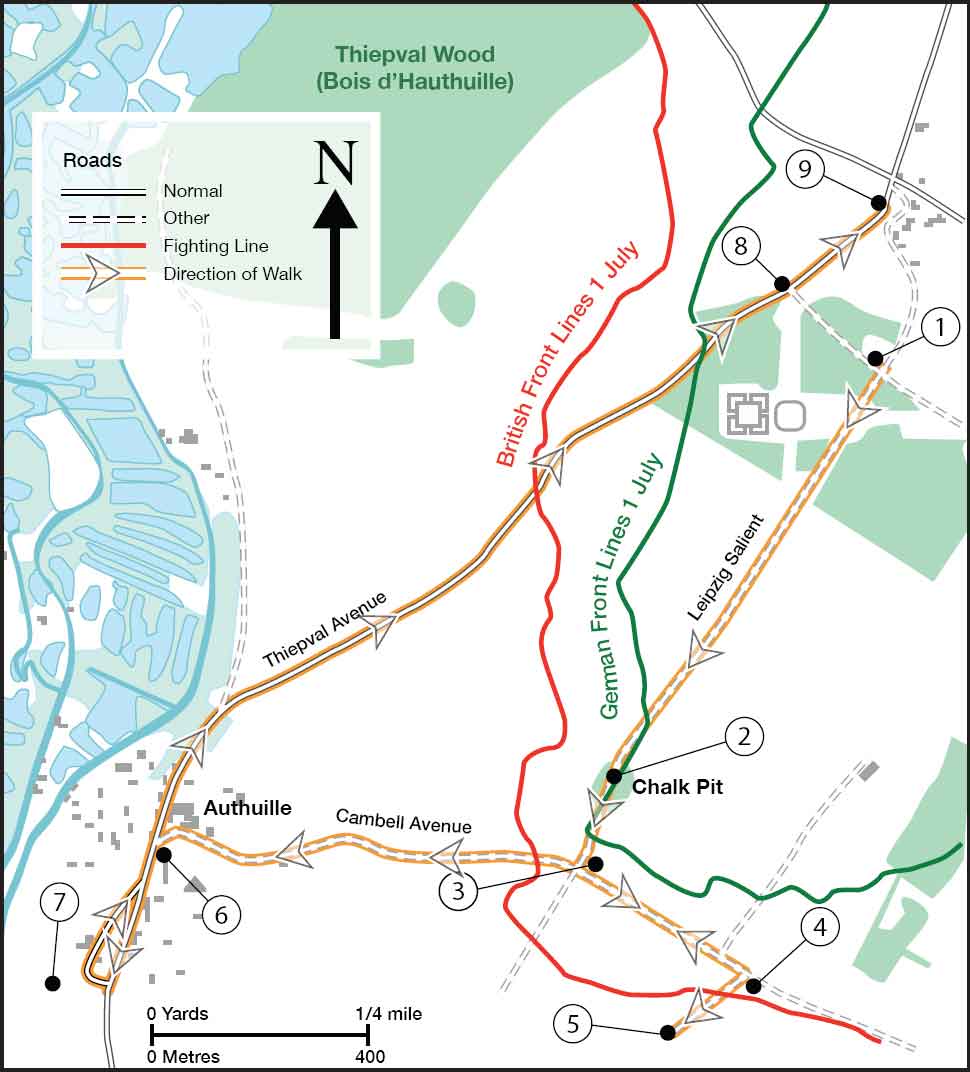
THIEPVAL - LEIPZIG SALIENT - AUTHUILLE - THIEPVAL
|
• Start/Finish Point: Thiepval Visitor Centre. GPS: 50.05122 2.68792 • Distance: 6.0 kms (approx. 3.7 miles). • Number of Visits en route: 9 • This route is over the area of the Leipzig Salient, fought for between July and September 1916. Details of sites en route are given at the Page number listed against each point. |
Notes: a. Parts are muddy in wet weather. b. A portable GPS and binoculars will add greatly to grasping the importance of the high ground of the Salient. c. ‘Holts’’ refers to the location on the Holts’ Battlefield Map of the Somme. d. The walk begins in German territory and moves towards the front line at the cross-tracks tip of the Leipzig Salient (Point 3).
1. Start/Finish Point.
page 94 Holts’ 2-G-44a
2. Leipzig Chalk Pit.
GPS: 50.04430 2.68133
3. Private Memorial.
page 99 Holts’ 2–G-49.
GPS: 50.04297 2.68015
4. Dorset Memorial.
page 99
GPS: 50.04121 2.68485
5. Lonsdale CWGC Cemetery.
page 100 Holts’ 2-G-49
GPS: 50.04006 2.68248
6. Authuille Memorials.
page 96 Holts’ 2-G-42a
GPS: 50.04305 2.66907
7. Authuille CWGC Cemetery.
Holts’ 2-G-42
GPS: 50.04078 2.66635
8. 18th Div Memorial.
page 96 Holts’ 2-G-44
GPS: 50.05273 2.68561
9. Carton de Wiart Memorial.
page 90 Holts’ 2-G-44b
GPS: 50.04430 2.68133
SUNKEN ROAD - MALINS - REDAN RIDGE - HAWTHORN CRATER
|
• Start/Finish Point: Argyll & Sutherland Highlanders Memorial. GPS: 50.08572 2.64853 • Distance: 2.75 kms (approx. 1.7 miles) • Walking Time: Approx 35 mins • Number of Visits en route: 9 • This route walks the Sunken Road featured in Malins’ famous photo of the Lancashire Fusiliers just before the assault on 1 July, and then heads directly towards and over the German lines of 1 July 1916. |
Notes: a. Parts can be VERY MUDDY in wet weather. b. ‘Holts’’ refers to the location on the Holts’ Battlefield Map of the Somme. c. We suggest that the route is followed as indicated, because a visit to No. 9 is much more meaningful at the end, once the overall lie of the land has been seen.
1. Start/Finish Point.
page 120 Holts’ 2-G-4
2. CWGC Redan Ridge No 2.
page 124 Holts’ 2-G-5a
GPS: 50.08892 2.65262
3. German Front Line.
GPS: 50.0872 2.65311
4. Track to Rue de Serre.
GPS: 50.08583 2.6557
5. 51st Highland Division Flagpole.
page 122 Holts’ 2-G-8
GPS: 50.08440 2.65613
6. Stained Glass Beaumont Hamel Church.
page 123 Holts’ 2-G-7
GPS: 50.08379 2.65625
7. German Front Line.
GPS: 50.08455 2.65150
8. Hawthorn Crater.
page 121 Holts’ 2-G-6
GPS: 50.08295 2.65048
9. CWGC Beaumont Hamel British.
page 121 Holts’ 2-G-3
GPS: 50.08589 2.64995

MANSEL COPSE - SHRINE ALLEY - MANSEL COPSE
|
• Start/Finish Point: Devonshire CWGC Cemetery. GPS: 49.98830 2.73586 • Distance 1.3 kms (approx. 0.8 miles). • Walking Time: Approx 20 minutes • Number of Visits en route: 7 • This route is in the area attacked on 1 July 1916 by the 9th & 8th Devons and 2nd Gordon Highlanders. Details of sites en route are given at the Page number listed against each point. |
Notes: a. Parts are muddy in wet weather. b. A portable GPS will add greatly in grasping how small an area the attack took place in. c. ‘Holts’’ refers to the location on the Holts’ Battlefield Map of the Somme. d. The broad axis of the attack was along the D938 towards Mametz with the Devons below the road and the Gordons
1. Start/Finish Point.
page 165 Holts’ 2-K-46
2. German front line trenches.
GPS: 49.99177 2.73490
3. German second line trenches.
GPS: 49.99367 2.73479
4. Shrine Alley Machine Gun.
page 162
GPS: 49.99367 2.73374
5. Railway Halt Machine Gun.
page 164
GPS: 49.99285 2.73204
6. German second line.
GPS: 49.99180 2.73314
7. German front line.
GPS: 49.99140 2.73357

DELVILLE WOOD - HIGH WOOD - DELVILLE WOOD
|
• Start/Finish Point: Delville Wood Museum Car Park. GPS: 50.02467 2.81270/ Footballer’s Memorial. GPS: 50.02428 2.80905 • Distance: 9.18 kms (approx. 6 miles). • Number of Visits en route: 9 • This route is in the area fought over from 14 July 1916 until late in September. Details of sites en route are given at the Page number listed against each point. |
Notes: a. Parts are muddy in wet weather. b. It is easy to spend over an hour visiting the Delville Museum, Visitor Centre, the Wood itself and the CWGC Cemetery. c. ‘Holts’’ refers to the location on the Holts’ Battlefield Map of the Somme. d. On some maps it is impossible to be precise about trench locations so we have used the term ‘Fighting Lines’ to describe the general positon of the front line trenches.
1. Start/Finish Point.
page 177 Holts’ 2-K-14/ 2-K-15a
2. Pipers’ Memorial.
page 182 Holts’ 2 – K-14c
GPS: 50.02615 2.80901
3. New Zealand Memorial.
page 183 Holts’ 2-H-26
GPS: 50.03954 2.80151
4. London CWGC Cemetery.
page 186 Holts’ 2-H-21
GPS: 50.03880 2.78235
5. Glasgow Highlanders Cairn.
page 185 Holts’ 2-H-22
GPS: 50.03804 2.78358
6. Public Schools Bn Tree.
page 185 Holts 2-H-23
GPS: 50.03693 2.78576
7. 47th London Div Memorial.
page 185 Holts’ 2-H-24
8. Cameron Highlanders & Black Watch Memorial.
page 184 Holts’ 2-H-35
GPS: 50.03881 2.78894
9. Bristol’s Own Cross Memorial.
page 158 Holts’ 2-K-29
GPS: 50.02515 2.79718
