DISTANCE: 115 miles (186km) from Boston to Provincetown by road; 57 miles (92km) by ferry
TIME: A full day
START/END: Provincetown’s MacMillan Wharf
POINTS TO NOTE: The fastest way to Provincetown is by ferry. If driving, head south out of Boston along the road Route I-93, then Route 3, cross the Sagamore Bridge, then follow Route 6, which runs for 60 miles (100km), down the hooked spine of Cape Cod to Provincetown. More scenic is traveling part of the way on Route 6a, running parallel to Route 6 to the west, and passing through several of the Cape’s prettiest villages, such as Sandwich and Barnstable. Provincetown is a seasonal destination; many places are closed during much of December and March and all of January and February.
Thick with craft shops, art galleries, stores selling nick-nacks and antiques, cafés, restaurants, and bars, ‘P-town’ is an unashamed tourist destination, but also, thanks to strict town ordinances, a beautiful-looking one. It is no surprise to find that generations of artists have been drawn to Provincetown and continue to practice here.
An hour-and-a-half ferry ride from Boston (or a two-hour drive), it is possible to make Provincetown a daytrip, although it is far better experienced on an overnight stay. Hiring a bicycle is recommended as distances from one end of Provincetown to the other are long; try Arnold’s (tel: 508-487-0844), just to the left as you leave MacMillan Wharf at 329 Commercial Street, or Ptown Bikes (tel: 508-487-8735; www.ptownbikes.com) at 42 Bradford Street.
Maps and other tourist information are available at the Chamber of Commerce (http://ptownchamber.com; Jan–Mar Mon and Fri 11am–3pm, Apr–May and Nov–Dec Mon–Sat 10.30am–5pm, June–Oct daily 9am–6.30pm), on the right as you leave MacMillan Wharf. See also www.provincetown.com.
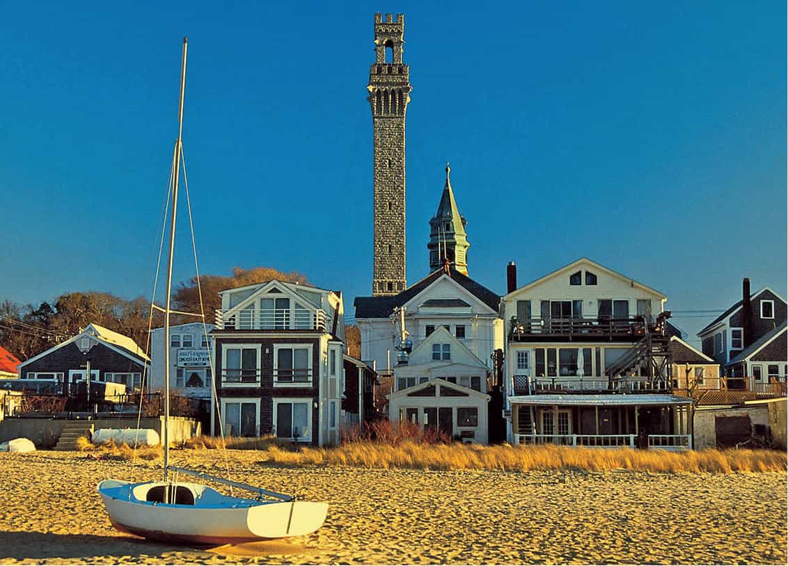
Provincetown with the Pilgrim Monument behind
iStockphoto
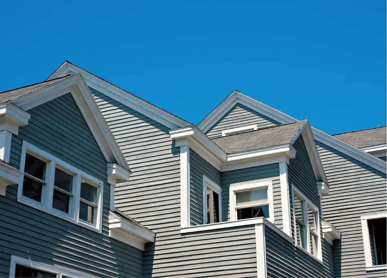
Typical architecture
iStockphoto
Ferry from Boston
The following route assumes you will arrive in Provincetown by ferry. Running between May and October, there are several fast ferries daily (90 minutes; $93 round trip), with little to choose between the services of Boston Harbor Cruises (www.bostonharborcruises.com), departing from Long Wharf, near the New England Aquarium, and Bay State Cruise Company (www.baystatecruisecompany.com), departing from the World Trade Center on Seaport Boulevard.
MacMillan Wharf
Ferries dock at MacMillan Wharf, toward the end of which you will find the Expedition Whydah 1 [map] (www.discoverpirates.com; mid-April–Oct daily 10am–5pm), a small museum documenting the remains of the pirate ship Whydah, which sank in 1717 off the coast of the Cape. Continue down the wharf, past the many boats offering whale watching and other ocean-going tours, to the Chamber of Commerce office for tourist information. Immediately ahead is Commercial Street, Provincetown’s principal retail thoroughfare.

Pilgrim Monument
Approaching Provincetown from land or sea, you cannot miss the slender granite tower rising up 252ft, 7.5in (77m) from High Pole Hill. To reach the Pilgrim Monument and Provincetown Museum 2 [map] (www.pilgrim-monument.org; daily Apr–Nov 9am–5pm), walk inland from Commercial to Bradford Street, then hike up High Poll Hill Road.
Inspired by the Torre del Mangia in Siena and completed in 1910, the monument commemorates the Pilgrims’ stop in Provincetown in 1620 for six weeks before they moved on to Plymouth. To get your bearings of Provincetown’s confusing geography, and for a grand 360-degree view of the Lower Cape, it is worth slogging up the tower’s 116 steps and 60 ramps. The fascinating museum at the monument’s base is strong on local history, and includes a section on the Arctic explorations of townsman Donald MacMillan (1874–1970).
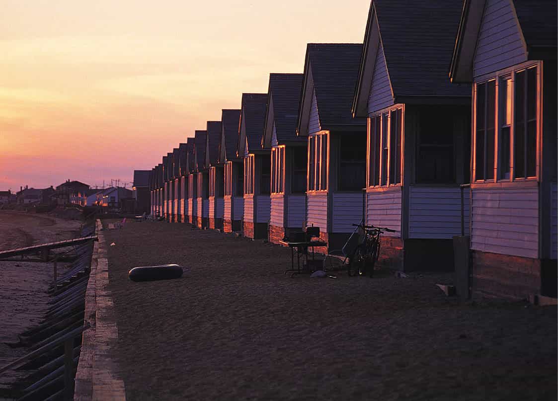
Tourist cabins
Mark Read/Apa Publications
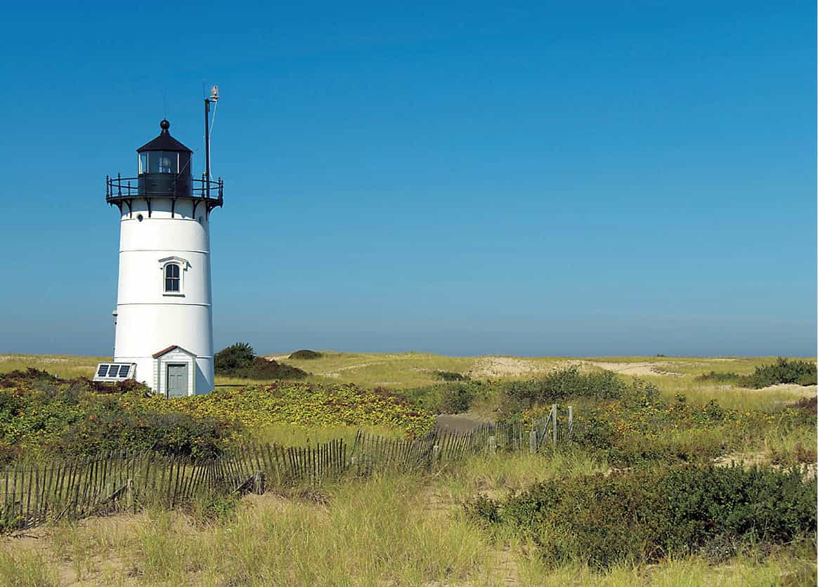
Race Point Light
iStockphoto
The East End
Return to Commercial Street and head left toward the East End. This is the artistic end of Provincetown, packed with galleries; you will find a concentration around The Mews, see 1 [map]. Before reaching there, pop into the Public Library 3 [map] (356 Commercial Street; www.provincetownlibrary.org; Mon and Fri 10am–5pm, Tue–Thu 10am–8pm, Sat–Sun 1–5pm), surely the only library in the world to house a fully-masted half-size replica of an Indian Schooner (the Rose Dorothea).
Provincetown Art Association
At no. 379 you can get a caffeine boost at Wired Puppy, then power on to the Provincetown Art Association and Museum 4 [map] (PAAM; www.paam.org; Thu–Sun noon–5pm) at no. 460. Top-class exhibitions are staged here, maintaining a tradition that started in 1899 with the founding of the Cape Cod School of Art by Charles Hawthorne.
The West End
Return to the center of town and continue along Commercial Street toward the West End. On the way you will pass many Provincetown mainstays, including the surplus store Marine Specialties Inc. at no. 235, an Ali Baba’s cave of sale items; the historic Atlantic House 5 [map] (4 Masonic Place; www.ahouse.com), better known as the A-House, once home to the playwright Eugene O’Neill and now an eternally popular gay bar; Café Heaven at no. 207, a great place for breakfast or lunch; and, at no. 190, Spiritus Pizza (www.spirituspizza.com), the place where everyone heads at 1am once the town’s clubs have shut.
Coastal cottages
Further down Commercial Street there are a few antiques stores, but once you have followed the road left around the Coast Guard Station the shops are replaced by guesthouses and private residences, with the sole restaurant being Sal’s Place, see 2 [map]. The numerous weatherboard cottages surrounded by flowergardens here are a sight to behold, particularly in the crisp ocean light.
Cape Cod National Seashore
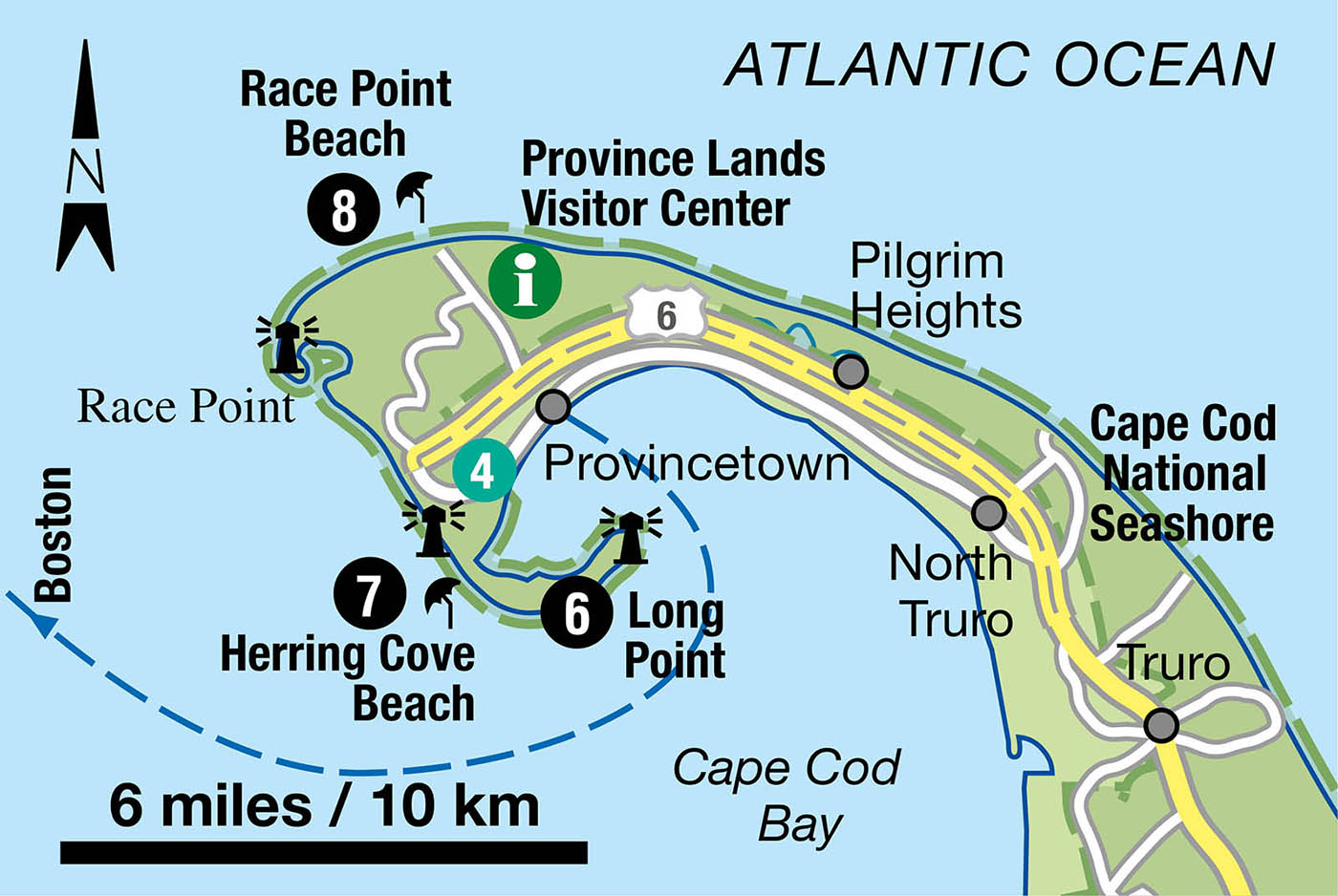
There are pleasant beaches either side of MacMillan Wharf, but Provincetown’s best strips of sand are part of the Cape Cod National Seashore (CCNS), including Long Point 6 [map], the slender sandbar that hooks back into Cape Cod Bay. You can reach here by walking across the breakwater at the far western end of Commercial Street; the uneven stones can make the crossing a challenge. Once on Long Point you can aim either right to the lighthouse at Wood End or left to the lighthouse on the tip of the sandbar – going in this direction you will pass the Provincetown nudist beach.
Along the coast
If you are on a bicycle or in a car, consider exploring more of the beaches and dunes. Heading north along the coast toward the Atlantic side of the Cape, Herring Cove Beach 7 [map] is popular with families and a fine spot to watch sunsets. Further around, and pinpointed by another lighthouse, is Race Point Beach 8 [map], behind which is Provincetown’s airport. You will get a fine view of the area from the observation deck above the Province Lands Visitor Center (www.nps.gov/caco; daily May–Oct 9am–5pm), where you can find out about ranger-led walks around the national park. Note if you bring your car or bike into the national park area there is a small charge.
If you came by ferry, head back to MacMillan Wharf to return to Boston.
Food and drink
1 The Mews
429 Commercial Street [map]; tel: 508-487-1500; www.mews.com; daily 6–10pm; $$$
As if the classy menu and ambience – with the lower level offering dining right beside the beach – is not sufficient, The Mews also sports New England’s largest selections of vodka. The food is pretty tasty too!
2 Sal’s Place
99 Commercial Street [map]; tel: 508-487-1279; May–Oct daily 5.30–10pm; $$
When other places are booked up it is often possible to squeeze in at Sal’s, an authentic Italian joint in the West End with a romantic beachside terrace. The portions are huge.