CHAPTER 2

MYSTERIES IN STONE
The Big Picture
Did ancient megalithic construction practices influence the cultural development of the Northeast Native American civilization thousands of years ago?
I believe evidence exists to support the theory that an ancient cultural group used the terrain and landscape of the Catskill and Shawangunk Mountains in upstate New York to carry out astronomical observations and preserved the information by manipulating the natural terrain to create alignments between landscape features and man-made monuments. Some of the alignments are configured over distances of up to twenty miles. If this could be documented, I believe it would reshape our understanding and concept of what ancient (prehistoric) people knew and were capable of accomplishing.
The evidence exists at sites that consist of different and various natural and man-made elements such as cairn fields, drystone walls, large set boulders, horizon hills, and so forth that combine to create landscape constructions that configure and align with the rising and setting sun on specific dates, such as on the shortest and longest days of the year.
In this chapter we will travel into the backwoods of upstate New York, looking at mysterious sites with constructions made of stone. No one claims to know for certain the story behind many of these ancient lithic structures. Having no official classification in history or prehistory, these sites fall between the cracks of archaeology and cultural anthropology, ending up as curiosities that baffle the experts and confound our attempts to provide a plausible explanation.
First, we will visit a cairn site deep in the Catskill Mountains. Cairns are typically considered mounds or piles made of stones that show some purpose and intention in their location and design. Many times these piles are left as markers to delineate a trail or route. Another common belief, backed up by some documentation, is that they mark or memorialize the location of an important event such as the death of a notable figure or the site of a critical battle, or serve as markers for tribal graves or sacred sites.
Over the years many hundreds if not thousands of these sites have been located in the northeastern United States, though many are now quickly vanishing due to spreading development and lack of protection. Over the years, various theories and assumptions have been offered up to explain the origins of these curious and mysterious constructions. These include land surveying, subdivision and property boundary markers, and land clearing for agricultural activity such as planting and grazing, as well as farm beautification. While some of these theories can be applied to some of these sites and locations, no blanket theory explains all of them. And many such lithic sites fall outside any theory at all.
In Putnam County, New York, hundreds of megalithic stone chambers have been documented. Many have been built and configured to align with the winter solstice sunrise, which is the sunrise on the shortest day of the year. In another instance, from the end of Long Island through Connecticut, across the Hudson River valley, and through the Catskill Mountains, an array of stone constructions has been discovered that all align with the setting sun on the summer solstice, the longest day of the year. In yet another instance, two large boulders (twenty-plus tons each) located approximately 18.5 miles apart—yet with a line of sight to each other—align to create both a winter solstice sunrise and summer solstice sunset alignment from clear ridge tops with east-west views.
Is it possible that parts of the northeastern United States were and are home to one of the largest concentrations of ancient astronomically aligned stone structures to be found anywhere? This is a question worth exploring. Regions of the Northeast, including New York’s Catskill Mountains and the Hudson River valley, may be some of the richest archaeoastronomical complex areas in the United States, with still-functioning solstice and equinox sunrise and sunset alignments. Researchers have documented hundreds of enigmatic stone structures and complexes still standing across the region.
This chapter will, I hope, shed some light on the purpose and people behind these mysterious stone structures and provide some insight into their lives and motivations.
We begin our journey by traveling up to the head of Spruceton Valley in West Kill, New York.
Spruceton Valley is located in a remote region of the Catskill Park preserve, at the heart of nearly a million acres of protected state lands. Heading into Spruceton Valley is like traveling back in time. You can practically feel the pace of time slow down as you head deeper down the valley road. Old farms and country cottages eventually give way to wooded mountainsides, forested slopes, and a narrow dirt road leading to the trailhead.
We follow a mountain stream, the headwater of the Schoharie Creek, along a state hiking trail until we reach the cairn field not far off the path to the north. Once we reach the cairns, we go into full investigation mode: measuring, plotting, photographing, sketching, and documenting the location and features of this particular site.
This is a spectacular assembly of beautifully formed, circular stone platform cairns. Some are as tall as three meters. Others show signs of having been constructed with small chambers or cysts built into their interiors. All have an esthetic quality and design form displaying purposeful intention. These are not just piles of stone thrown together.
Nearby is a stone wall that encloses most of the cairns. In all, about two dozen large cairns are present along with many smaller piles of stone, gathered and placed onto small boulders or bedrock outcrops.
Sites like this were first seriously studied by the team of Mavor and Dix, who were pioneers in the scientific identification and classification of lithic sites in New England. Dix was an optical engineer and Mavor a marine engineer and naval architect from the Massachusetts Institute of Technology who worked at Woods Hole Oceanographic Institution. Mavor was instrumental in designing the Alvin submersible research vehicle. Mavor also directed the undersea archaeological surveys of Minoan ruins off Santorini in the Greek Isles in the late 1960s.
Manitou: The Sacred Landscape of New England’s Native Civilization, the book they coauthored in 1989, went a long way toward proving that the northeastern Native Americans built with stone and that in many instances the purpose of their constructions was to determine, through marking astronomical observation, the timing of celestial motions—lunar, solar, and stellar—creating calendar sites that tracked the cycles of nature, both long and short.

Fig. 2.1. Circular platform cairn located in Spruceton Valley, West Kill, New York (a); circular “cyst” cairn also located in Spruceton Valley (b)
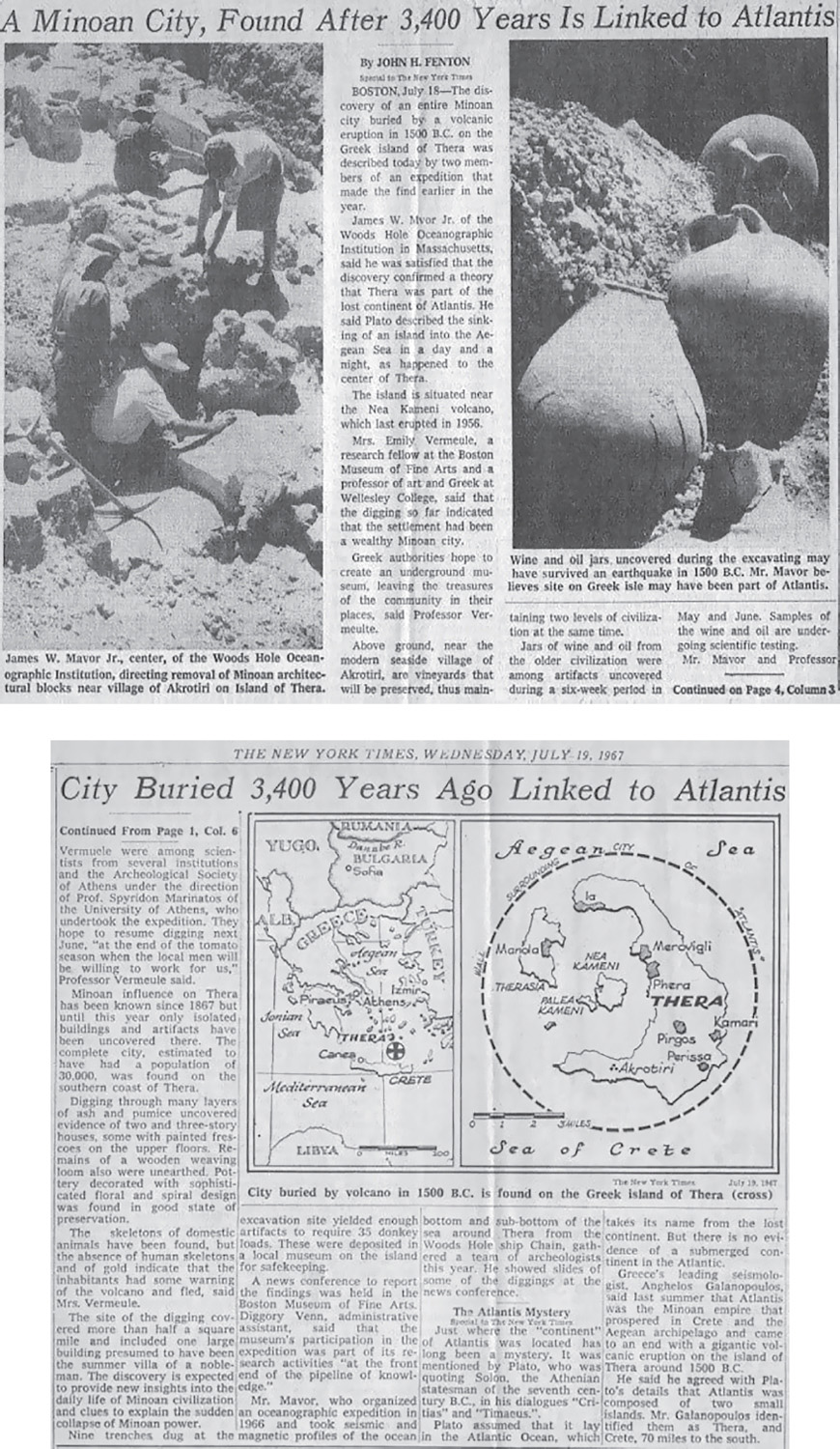
Fig. 2.2. An article featuring James W. Mavor Jr. appeared in the New York Times, July 19, 1967.
So if this was a tradition carried to the Spruceton Valley site deep in the Catskill Mountains, what would be the evidence proving this site is configured to align with a solstice sunrise or sunset?
Such an alignment would seem to put this geographic area in good company with many other sacred sites that have markers aligned with the yearly solstices, including Newgrange in Ireland, Uaxactun in Guatemala, Palenque in Mexico, and the Temple at Karnak in Egypt.
When we first visited this cairn field and stone wall we took note of their locations, plotting the GPS coordinates on a project map that included similar sites that were underresearched. Many of the sites are located along a path that leads to the setting sun on the solstices. In the northeastern United States, the angle of that path is approximately 123° southeast for the winter solstice sunrise and 303° northwest for the summer solstice sunset. Both angles are based on true north and form a 180° straight line from southeast to northwest. Standing along this line, with an unobstructed view to the horizon, one would see the sun rising on the southeast horizon on the shortest day of the year, the winter solstice, and six months later, if you turned around 180°, you would see the sun setting at that point on the horizon, on the longest day of the year, the summer solstice.
All this raises the question: would constructions aligned with the solstice or equinox sun remain true, that is, still stay in alignment, after hundreds, thousands, or even tens of thousands of years? The answer is they would, as has been proven at many locations, by observers for centuries, from the Mayan sun pyramid of Kukulkan at Chichen Itza to the temples of Egypt and Angkor Wat in Cambodia. This is because, while the sun is observed to precess backward through the constellations approximately one degree every seventy-two years, due to the precession of the equinoxes (a 25,700-plus-year cycle), this is only relative to the stars in the sky and not the sun’s positions on the horizon, which would remain nearly constant over very long periods of time. Over five thousand years there would be a negligible change to the naked eye due to the precession of the equinoxes and even less due to the obliquity of the ecliptic, an even longer and subtler cycle lasting millions of years.
Given what we know of other cultures that built in stone and aligned their monuments to the solstice horizon, is it possible some of the cultural beliefs and influences of these civilizations, the Egyptians, the Celts, and others, were exported worldwide during the time when those societies were at their high point, several thousand years ago? Were their ideas and practices visited on North American shores in remote times? Did certain cultural beliefs and ideas diffuse across the globe and take hold among early humans? Or perhaps did different groups develop these cultural ideas and practices separately and in isolation from one another with little or no contact? Between diffusion and isolation, the evidence supporting diffusion appears to be mounting, helping account for the continuity present among certain common elements in many ancient myths and legends, as well as in flora and fauna.
So if there is a solstice alignment to be discovered at the Spruceton Valley cairn site we should be able to document this by viewing a winter solstice sunrise or summer solstice sunset from the location. So we plan to be up in Spruceton Valley around December 21 to witness the sunrise on the solstice and confirm or dispute whether such an alignment exists.
But first we have to determine what elements in the construction and configuration of the cairn field and stone wall could potentially create a solstice alignment. We break out our compasses and begin to check out the angles between aligned rows of cairns and the lengths of stone walls, looking for angles that match that of the path to the solstice sun setting on the horizon.
Having determined that the rows of cairns and stone walls in Spruceton Valley do appear to have angles aligned with the winter solstice sunrise, we arrive before dawn on December 24 while the sun is at its winter standstill to see if these elements of the cairn complex are aligned to this celestial event. Again, in the northeastern United States, the angle of that path is approximately 123° southeast for the winter solstice sunrise and 303° northwest for the summer solstice sunset.
Using the length of wall running southeast to sight our compass and cameras, we wait in the dark for the first rays of light to begin to streak the night sky’s darkness. As the approaching sun’s early rays start to lighten the sky, we’re hoping the sun’s disc will appear on the southeast horizon, in a gap up the valley between the ridgeline of two looming mountains to the south and to the east, where the stone wall points. If the sun appears at that spot and the stone wall is pointing directly at that spot as well, we’ll have confirmed this alignment.
And it happens: we see that the Spruceton Valley cairn complex has elements, including the stone wall and a straight row of large, well-formed cairns, that align with the winter solstice sunrise. It would appear one of the purposes of the site was to record and preserve a celestial event that was being observed by those who constructed and used the site. But that doesn’t answer the question of who built the wall and the cairns or when. With no artifacts associated with the location having been discovered or identified, clues to who was responsible or insight into when the structures were built are extremely difficult to discern. But I can’t help think that perhaps Mavor and Dix would favor the pre-Columbian local Native population of the area as the most likely candidates responsible for constructing this type of site.
But now, knowing what the site was used for, perhaps more telling than who and when is why.
Searching for an answer, we must ask: why should ancient cultures be so preoccupied with keeping track of the movements in the heavens?
Knowing the cycles of nature, of course, was the key to predicting the seasonal changes. Finding ways to keep track of astronomical observations has probably been the single biggest influence on the development of math and science as well as myth, beginning for mankind in preliterate times.
In the book Hamlet’s Mill: An Essay Investigating the Origins of Human Knowledge and Its Transmission through Myth, published in 1969, Giorgio de Santillana and Hertha von Dechend, both professors of history at the Massachusetts Institute of Technology, raise the thesis that the single biggest preoccupation of most ancient cultures was the tracking of the precession of the equinoxes. Its connection to the ages of the zodiac and to what Plato and the ancient Chinese referred to as the Great Year, consisting of the alternating golden, silver, Bronze, and Iron ages, was what accounted for the rise and fall of civilization and consciousness over the course of many thousands of years. Could there be more to the myths of a lost golden age than we realize?
De Santillana and von Dechend argued convincingly that most ancient myths and legends contain common elements and use a technical or scientific language cloaked in symbolism and allegory that contains real astronomical information supporting the notion that our solar system is subjected to celestial forces that always spin in a continuous cycle, a mill if you will, though sometimes the mill grinds out gold, other times salt, and yet other times dirt.
This belief closely correlates with the East Indian Vedic belief in the Yuga cycles, which again are believed to be driven by the precession of the equinoxes. The Holy Science by Swami Sri Yukteswar explores this theme as well, defining the length and describing the characteristics of each age, or Yuga, as it applies to the human condition. His book, published in 1894, contained astronomic information drawn from ancient Vedic texts that references concepts and principles that have been borne out by “modern” science in the century since its publication. These fascinating facts should be considered and applied appropriately in the context of an enlightened scientific process, but as of yet have not.
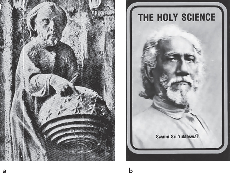
Fig. 2.3. God creating the stars (a); The Holy Science by Swami Sri Yukteswar (b)
Turning back to the mystery at hand, in the Dutchess, Putnam, and Westchester County region of the Hudson River valley are located hundreds of mysterious stone chambers. These megalithic structures have entrances aligned to the winter solstice sunrise, and many are said to resemble an eye and are thought to have a Celtic/monastic influence. Official explanations for the chambers range from colonial root cellars to icehouses or livestock pens. And true enough, some or all may have been used for such purposes over the course of their existence. But it is interesting to note: nearly all early colonial land deeds and surveys include descriptions and references to these preexisting constructions. If these constructions were not originally from the colonial period, then the story becomes more intriguing.
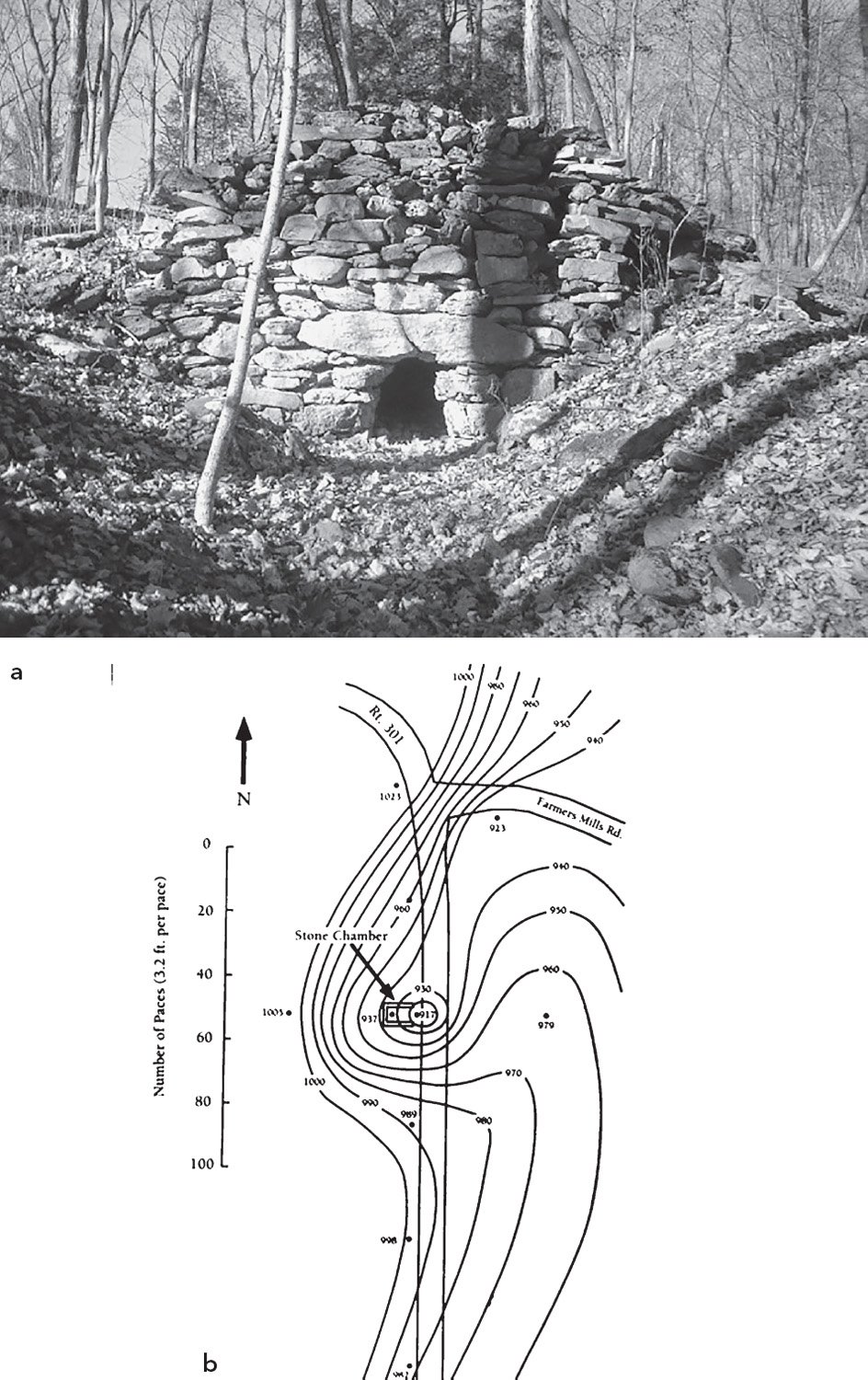
Fig. 2.4. Hudson River valley stone chamber (a); location of stone chamber associated with electromagnetic “hot spot” (b)
Because of their mysterious nature, the stone chambers of the Hudson River valley have been the subject of investigation by a number of researchers over many years. Through the research of John Burke and Kaj Halberg, authors of Seed of Knowledge, Stone of Plenty, it’s been discovered that many chamber sites are associated with electromagnetic “hot spots” or are located in areas that show an increase or spike in the power density of the Earth’s electromagnetic field strength at that particular spot, as measured with electronic sensor equipment. This is a fascinating discovery.
Burke’s groundbreaking work shows that a control group of maize seeds placed in indigenously or traditionally identified electromagnetic hot spots, including Native American chamber locations, produced far more robust yields than an “unexposed” control seed group left in his lab to grow.
One can’t help but wonder how these electromagnetic hot spots were originally identified by the chamber and mound builders. Was it an act of divination? Were “sensitive” individuals, such as shamans, employed to locate energy sources (think spirits) through divination or dowsing?
Another theory suggests that those who built and used some of these structures were purposefully trying to manifest good energy by stripping negative ions from hydrogen electrons in water molecules. Negative ions are charged particles in our atmosphere. This process is known to occur by the act of water running over the surface of certain stones (bluestone, for instance) and through constrictions in rock, natural or man-made. Releasing negative ions, which tend to rise to the highest place on the landscape, such as hills and mountaintops, is known to assist in attaining and enhancing a heightened or enlightened mental state. I think there are big clues here that need to be further investigated and studied.
Concerning the electromagnetic hot spots, it is interesting to speculate: Do ley lines, that is, unseen energy meridians, connect such locations, creating an earth grid or energy pattern across the Earth’s surface? Can their effects be focused or directed by structures constructed in a particular configuration or built of specific, energy-conducting materials? Does the shape of mounds, standing stones, or henges—wood, stone, or otherwise—help direct the flow of this energy field and account for certain architectural designs and configurations at ancient sites? Does this help account for feng shui and similar principles from the East? Is this the geomagnetic energy field that birds and butterflies tune in to to navigate while migrating great distances? No one claims to know for sure, but in my article titled “Electromagnetism and the Ancients,” I state that electromagnetism is the single common denominator of everything in nature, of everything that exists in the universe. And that perhaps the electromagnetic spectrum, that naturally occurring, continuous band of energy ordered and organized by frequency and wavelength, is the single medium on which all of existence is recorded.

Fig. 2.5. Two views of the Avebury stone circle in England
It becomes even more intriguing when we note that many megalithic “sacred sites,” such as Stonehenge, Avebury, Callanish, and many others, have long stone rows and circles in which, it’s recently been determined, the standing stones in each set all have their magnetic polarity, their north-south axis, if you will, lined up in the same direction. The result would be a configuration that would accelerate energy particles (protons, electrons, etc.) along its path, not unlike a modern, high-tech, particle accelerator. The Large Hadron Collider, located at the CERN particle physics laboratory in Switzerland, is one example. This new supercollider is being used to solve the greatest questions in physics—the energy/matter transfer question—by locating the so-called God particle. Just like today, ancient people must have wondered what the folks building these structures were trying to accomplish. Were they attempting to release the Earth’s own energy, to tap into the innate energy field of our living planet, of our living universe, to access its beneficial properties?
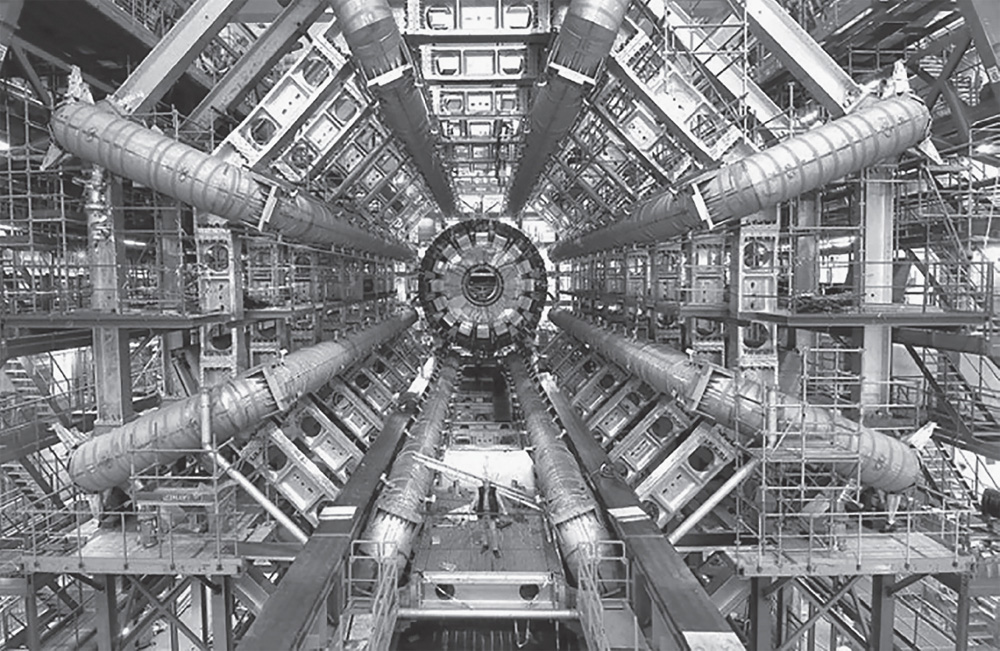
Fig. 2.6. The Large Hadron Collider in Switzerland
Back to the stone chambers: maybe these chambers serve multiple purposes, certainly as shelter from the extreme cold of winter where people could huddle together for warmth, and perhaps as an astronomical observatory by which the dates of the solstices and equinoxes were determined and monitored. It seems only logical that a structure built for astronomical use a few days of the year would serve a dual purpose or multiple practical purposes at other times, for storage, shelter, and so forth—and maybe also as a place where crop seeds could be treated, blessed by the powers of the unseen world, in a way that produced increased crop yields.
Is there sufficient evidence to draw these conclusions? Probably not, but there are definite and important clues that should be investigated and worked out.
In terms of geography, for the distribution of these lithic sites and monuments, for sites and their settings, in some cases we can approach monument location using the concept of view sheds (i.e., the landscape features that can be seen from each monument). Other researchers and I have also explored similar approaches, focusing on the intervisibility between neighboring monuments and the monument’s and chamber’s alignment or orientation to other sites or the horizon when it is clear that there is intentionality in the distribution and orientation of site monuments, which may use a series of locations. Although some of these approaches may be seen as flawed, the interaction between location, monument construction, and landscape must be considered as being important to a monument’s builders and users.
Ever since sites like these were discovered, there has been an unresolved debate for archaeologists and the general public alike regarding their function and purpose. The three main theories regarding the cairn’s origins or purpose are that they may be part of land surveying or subdivisions; that they are a part of agriculture-related land clearing for farming or grazing; or that they are some sort of symbolic monuments. There are, however, flaws within the land surveying and agriculture theories, and to claim that they are symbolic monuments seems too much of a default solution. As a real reason for them has yet to be determined, this line of research looks beyond any single site to the surrounding environment and analyzes the design related to the landscape to show that many are inherently aligned to celestial events and geographical elements and that the ancient Neolithic builders may have used these sites as a link or connection between them, their home, village, or territory and the powers and motions of the universe.
Now, after some time, many of the sites and features—the groups of cairns, walls, chambers, even individual stones—begin to take on a familiar look. Researchers in eastern New England have generated a lot of material relating to lithic sites, some of which seem to be related to this tradition of aligned stone monuments. In the western United States there are many lithic sites that seem to be in the same tradition as what we’ve seen here in the East. Perhaps we may be approaching the time when we will begin to get the hang of the thinking and purpose underlying these assemblages.
I believe the key to finding this out is researching the various myths and legends associated with these types of sites, but this information is not easy to come by. Regarding folklore, myths, and legends, while legends can be seen as stories passed down through time—which may have a seed of fact as their basis—I consider myths more like theories or ways in which ancient man attempted to explain what he experienced and observed in nature around him. Only in myths, symbolism and allegory are substitutes for the technical language and scientific terminology used in modern theories.
A. C. Ross, Ph.D., researched the oral traditions of more than thirty-three Native American tribes for his book We Are All Related. He documented the various yearly ceremonies and rituals carried out by the tribes and discovered that the dates these celebrations took place all fell on or near the summer and winter solstices and spring and fall equinoxes (Ross 1989).
It is also interesting to note that the traditional Native American tobacco ceremony, documented by the first arriving Europeans and still conducted in places today, as well as honoring Grandfather Sky and Grandmother Earth, pays homage to the four cardinal directions with a symbolic animal and relates each direction to a season of the year and a stage of human life.
These facts raise the question: how did the ancient Americans determine and keep track of these celestial dates and cardinal directions without calendar or compass and preserve that knowledge for future generations without a formal writing system? Certainly a concrete notion of where the four cardinal directions lie, as well as the motions of the sun and moon, would be essential to making such determinations.
As already noted, knowing the celestial cycles of nature was key to predicting the seasonal changes, and finding ways to keep track of astronomical observations was probably the single biggest preoccupation of ancient, pre-literate humans, including those who lived in our woods. Some of these sites may be evidence that the ancient inhabitants of this land were involved in this undertaking. And as we search for this lost knowledge, we should keep in mind that our so-called primitive ancient ancestors knew and attempted far, far more than traditional, orthodox academia gives them credit for today.
Are some of these monuments and constructions evidence documenting, confirming, and acknowledging that ancient Native cultures present in this region were practicing careful celestial observations and attempting to preserve the knowledge learned from those observations in man-made or manipulated landscape monuments? And if so, did they develop this practice themselves, or was it taught to them by those traveling through or arriving from elsewhere?
It appears southeastern New York State may be home to one of the largest concentrations of astronomically aligned stone structures to be found anywhere, with hundreds of documented, enigmatic stone structures and complexes still standing across the Catskill Mountain and Hudson River valley regions. This may well be the richest archaeoastronomical complex area in the United States with still-functioning solstice and equinox sunrise and sunset alignments. Solving the mystery of who built these structures, when, and why is a question worth seeking an answer to in order to discover more about our own humanity, who we are, and from where we came as we endeavor to learn from those who came before us.