CHAPTER 11

CARNAC: STONES FOR THE LIVING
Pierre Mereaux’s Classic Work

Translation and Commentary by Ros Strong
PART I

Abstract
Pierre Mereaux, Carnac: Des pierres pour les vivants, Spezet, Bretagne, France: Nature & Bretagne (1992 Edition): 244 pages.
This incredible book was sent to me some years ago by Patrick Ferryn, who is an enthusiast of Pierre Mereaux’s work. I immediately felt that someone needed to make his original research available in English because it is meaningful to everyone interested in megalithic construction and cultures worldwide. I read French slowly and could not dream of translating the whole book, even though his writing style is simple and direct.
I had the good fortune to meet Mereaux in Brussels in 1994, and he graciously corrected my translation and encouraged my efforts. Unfortunately, he died a few years ago. Mereaux was by training an engineer specializing in thermodynamics, but for thirty years he spent his vacations in a painstaking study of the megaliths in the Carnac region, and his preface explains his passion. “I am not a graduate archaeologist; I am but an amateur—from the Latin amator, he who loves, and, if I am passionate about prehistory and especially the megalithic epoque, it is perhaps by the pure spirit of research.”
Why is this Mereraux’s work so important? Mostly because Mereaux asks many of the same questions that we have been asking about our enigmatic American stonework, but he looks at these questions in a very original way and in great detail. Why were these monumental structures built? Why in a particular location? What purpose could have been worth the tremendous effort? He examines the geology, the fault lines, the effects of granite and quartz, seismic activity, and magnetic and gravitational anomalies, as well as the local myths and ancient names. I feel strongly that if researchers today apply the insights provided by Mereaux to some of our current mysteries, we might be on a new path to answering some of the questions we have been wrestling with for years.
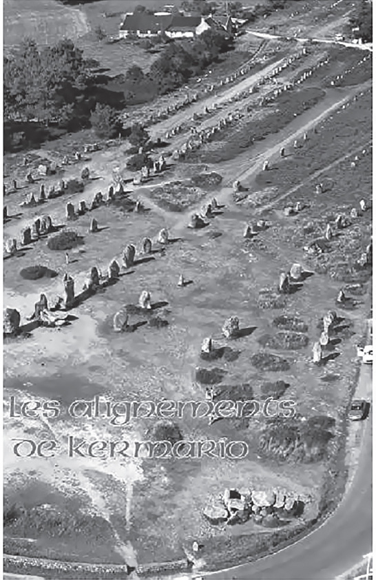
Fig. 11.1. Postcard showing the alignments of Kermario in Carnac, Brittany, France
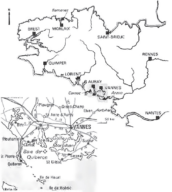
Fig. 11.2. Locus map of the Gulf of Morbihan on the south coast of Brittany, France
Chapter I—Les Morts et L’astronomie
(Astronomy and the Dead)
Mereaux expresses amazement that people who lived in simple dwellings exerted such a huge effort in their stoneworks in the same places for thousands of years. He asks why. Dolmens pour les morts by Roger Joussaume appeared in 1985 (published in English as Dolmens for the Dead). Mereaux never accepted the cult of death as the primary reason for these constructions. Others felt the same way—Pierre-Roland Giot, for example, a Breton archaeologist with an international reputation. Were there other purposes such as astronomical alignments? There seemed to be no reason to erect thousands of stones to verify certain risings or settings of the sun or moon. It would have been much simpler for the builders to plant wooden poles. Professor Alexander Thom and others worked in Brittany during the 1960s and tried to make their theory of astronomical alignments fit, but the sites appear to be more elaborate than needed. Mereaux lists more than 1,200 menhirs, in alignments that Thom neglected to study, that did not fit his theory.
More questions follow: Why quarry the stones at a distance when there were plenty nearby? The type of stone for a specific spot seemed important. A different type of granite? What was the purpose? Religious use? Perhaps. Temples? What religion? Giot also remarks that calling everything religious often hides one’s ignorance. Mereaux frowns on those who find idols everywhere. Although they seem not to have been built as tombs, the sites were sometimes rediscovered later and used as tombs by people who were ignorant of their original purpose. Mereaux was never convinced that a cult of the dead was a primary element in the lives of these people.
Chapter II—L’énigme des Petites Pierres
(The Enigma of the Small Stones)
In this chapter Mereaux considers the ornamentations of the dolmens and menhirs and concludes that they have nothing to do with “art.” The designs, however, would be legible to a certain elite, with other meanings that he feels he has discovered. The designs were not left to workmen—there had to be a foreman—and there must have been “models” as examples for the graveurs (carvers) to follow. These would need to be easily transportable. If on skin, they would have been perishable. We do find some curious small stones, sometimes within, sometimes outside the dolmens. Some are found near the quarry, and some show polish before engraving.
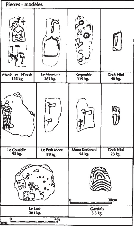
Fig. 11.3. Engraved “model stones”
The ten stones shown in figure 11.3 weigh 5.5, 23, 46, 59, 94, 95, 119, 133, 262, 361 kilograms: too small to be part of the monuments. Among these ten are found practically all the motifs of the engravings of the forty-four dolmens of the region. Four of the six allée couvertes (covered corridors)—which will be discussed later—have another astonishing characteristic, for which these small stones must have been the models.
Chapter III—Une Histoire de Table, de Balance, et de Mesure
(A History of Slab, of Balance, and of Measure)
Here the names given to dolmens are investigated. These names never have any reference to a cult of the dead or death. In popular usage of the past, dolmens are home to korrigans, kornandons, poulpiquets (dwarfs, elves, fairies), or sometimes the devil. Almost all names relate to magic of a certain type. Was it because a dolmen was a sacred place or a dangerous one to those who were ignorant? Investigating traces of the ancient language can be a help in answering this question.
Conventional wisdom has it that the terms dolmen, menhir, and cromlech were totally unknown in ancient Breton. Mereaux disagrees, citing a 1464 dictionary (the oldest known). In this dictionary men means “pierre” or “stone,” and taul means “table”; stone table would be pronounced “mentaul” or “moentaul.” He gives a reference to a glossary of old Breton by Joseph Loth, published in 1884 and reprinted in 1970. In this source mentaul means “balance.” In a Gallic manuscript of the eighth century, montaul means “balance.” In modern Breton, taol means not only “table,” but also “a knock, a stroke.” Ment also relates to “grandeur, quantity, a measure of some sort.” In the 1921 book Les Indo-Européens by Albert Carnoy, this definition is given: “The moon-MEN seemed to be called la mesureuse, the measurer, because it served to count the months” (Latin, menses). The Indo-European root men implies the idea of thinking, memory, souvenir. In Dictionnaire de la langue Bretonne, from 1752, Dom Louis Le Pelletier translates menac as “souvenir, memory,” which is reflected in the name of the two alignments at Carnac and Trinité-sur-Mer. A complete translation would delight linguists, but Mereaux claims no expertise.
Note that the huge monuments of Minorca, each one pillar with one horizontal stone, are called taula, which means “table” in Catalan and in Sanskrit. “Balance” is tula, which is the name of the constellation of the balance (scales) in the ancient Indian solar zodiac. The Sanskrit akmen implies the idea of a stone, point, anvil, weapon, or hammer, and all these terms have in common the idea of hitting ( frapper), “to give blows with the end of a pointed stone or perhaps on a pointed stone.” The tables of the dolmens are “in balance” and they can oscillate, but on points and evidently under the influence of an exterior force. The idea of “measure” concerns the amplitude of these oscillations or, to be more precise, of these vibrations. The coup de foudre (thunderbolt) or fendence de terre (splitting of the earth) touches on the seismes (earth tremors, or earthquakes) that cause these same vibrations and also a certain form of electricity, as much telluric as atmospheric.
The term men in its double sense of “stone” and “memory” could signify that certain stones were destined to perpetuate not just the souvenir (memory) of a person or an event, but also the knowledge of something in conjunction with natural phenomena that are purely physical and above all geologic.
Chapter IV—La Danse Sur Pointes des Tables à Trois Pattes
(The Tables with Three Feet Dance on Points)
Near the town of Locmariaquer, there are three remarkable dolmens: Table des Marchands, Mané Lud, and Mané Rutual. They have three features in common: the tables (roof slabs) that cover the chambers are abnormally large, the most massive of the region; all three have been broken; and all are made of granite. They have the following dimensions and weight:
Table des Marchands: 18 cubic meters, 49 tons
Mané Lud: 20 cubic meters, 53 tons
Mané Rutual: 27 cubic meters, 72.5 tons
The engravings (carvings) on the undersides are called hache-charrue (plowshare or axe-plow), crosses (crosiers, or crooks), and idoles (idols). In figure 11.4 (p. 257), the dots indicate the precise spots where the slab rests on the vertical supports. The question is why these enormous covering stones were placed on three sharp points on a very small surface with an excessively large overhang. The large overhang put the capstone at the limit of its stability. The slightest shock would have put it in vibration. The weight of six men jumping on the extremity of the overhang would have been sufficient to break it. Mereaux has convincing figures dealing with weight and size. The differences between the overhanging or broken pieces are between 323 and 378 kilograms; they are so similar they must be deliberate (see figure 11.4). He also notes rocking stones in Brittany, Scotland, and Ireland with Celtic and Druid connections.
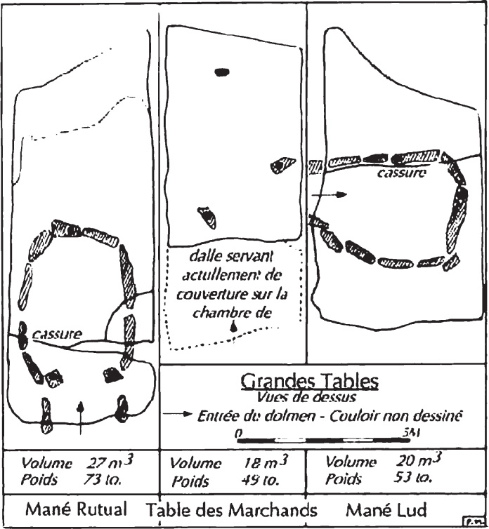
Fig. 11.4. Top view of the capstones of three major dolmens with their volumes and weights and the line of the break point (cassure) on two of them
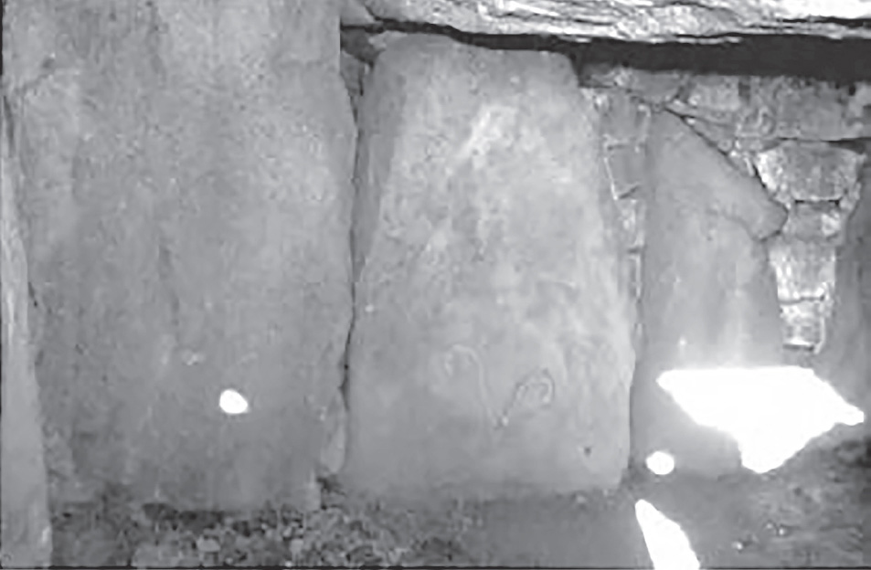
Fig. 11.5. Interior of Mané Rutual (Photo: Ros Strong)
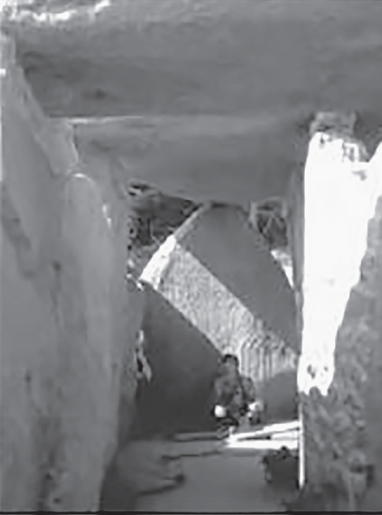
Fig. 11.6. Interior of Table des Marchands (photo: Ros Strong)
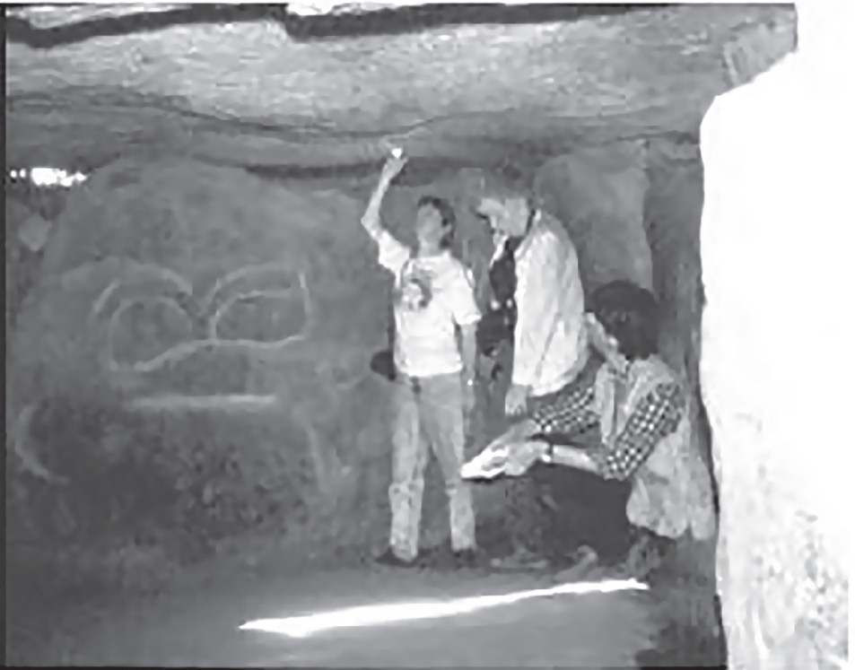
Fig. 11.7. Interior of Mané Lud (photo: Ros Strong)
Chapter V—Un Escalier Branlant
(A Tottering [or Rocking] Staircase)
Since the 1981 publication of his earlier book, Carnac, une porte vers l’inconnu (Carnac, A Door to the Unknown), Mereaux continued his research and made new, more precise discoveries. This chapter presents new theories derived from his methodical studies. He spent a great deal of time on a careful study of large-scale topographical and geological maps. The southern Morbihan region resembles a vast stairway that descends in terraces toward the Atlantic.
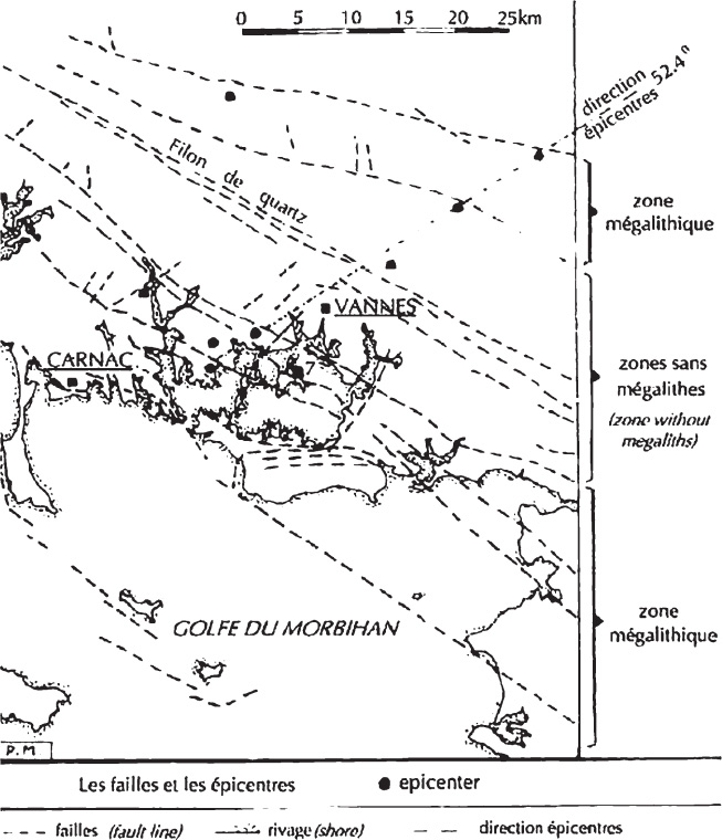
Fig. 11.8. The faults and epicenters in the Morbihan region, showing zones with and without concentrations of megaliths
In the Morbihan region, there are two series of geological faults that run northwest-southeast with a large quartz vein between them. There are also numerous small fractures running northeast-southwest with a small quartz vein. The Earth’s crust here is thin and unstable. In figure 11.8, note the two separate zones with megaliths and the center area with no megaliths. With a few minor exceptions, there are no traces of megaliths for three hundred square kilometers. Mereaux wondered if the megaliths of the northern zone were older than those of the south. Carbon dating gives dates ranging from 4410 BCE to 3360 BCE in the north and from 3775 to 3497 BCE in the south—not a great difference. So why this “hole”? There was no lack of stone. He thinks this may be due to the enormous concentrations, in depth and on the surface, of schist, gneiss, and granite that modify the local magnetic field. The same effect has been noticed all over the globe and has been measured by the satellite Magsat, which was launched by the United States in 1979, but Mereaux thinks there are other reasons.
More than 90 percent of the dolmens in the two zones have their corridors oriented to the southeast, between 101° and 131° (average 116°).
Most contemporary authors see a relationship of the dolmens with the sunrise. But the faults are also oriented between 103° and 130° (average 117°). Is this accidental, or is there another reason? All Breton geologists know that the southern part of their province is and always has been the region in France most shaken by seismic activity. A medieval manuscript says that in 1236 the earth shook in the country of the Venetes, causing great damage.

Fig. 11.9. Chart comparing the orientation of the Morbihan dolmens with the orientation of the fault lines
Since the beginning of the twentieth century, thirty or more earthquakes have shaken the area, thirteen of intensity IV on the Mercalli scale (4–4.9 on the Richter scale). The earthquake of January 9, 1930, was of intensity VII (6–6.9 Richter), causing a lot of damage. Eight principal epicenters are found in the immediate proximity of a fault (figure 11.8). Three are in the north zone, five are in the south zone, and in the central zone—no megaliths, no quakes! It must be the reason, Mereaux notes, that we find so few megaliths. A look at the map shows that five of the epicenters are practically situated on the same line oriented to 52.4° northeast. Also, the depths of the quakes are between three thousand and twenty-three thousand meters (ten thousand on average), which is not very deep. Since 1954, sixty thousand quakes surveyed worldwide have had a depth of more than seventy thousand meters. These Breton quakes, so near the surface, are no doubt influenced, if not caused, by exterior forces!
Looking at the calendar, we discover that the quakes all occurred between September 21 and the following March 21, between equinoxes. About half were between September 21 and December 21, the other half from December 21 to March 21. Geologists and seismologists offer no explanation.
After estimating the volume of water rushing into the Gulf of Morbihan, studying tide tables, and so on, Mereaux suspected that the volume and weight of the total amount of water penetrating the gulf and the height differential in the tides could be factors in causing seismic events. The average high tide height is 4.63 meters during the equinox of March/April and 3.70 meters for the solstice in June/July. In March, 400 million tons of water rush in; in June, only 190 million tons. In 6000 BCE, the sea level was lower by several meters, gradually rising, with important variations about 1400, 700, and 200 BCE. About the sixth century CE, the sea was probably three to four meters higher; it regressed until 1905 and rose fourteen centimeters a year until 1959.
Mereaux made a huge chart for every day of the year and noted the dates of every earthquake in the Morbihan for the last eighty years, the course of the sun, the visible phases of the moon, the cycle of the moon from perigee to perigee, and the height of the high tides.
He concluded that the numerous earthquakes of the gulf are caused and facilitated by the following:
- The thinness of the Earth’s crust at the spot and the faults that furrow the region.
- The conjunction of the sun and moon during full and new moons, as the attraction deforms the surface of the globe and generates the tides, both of the Earth and the ocean. This phenomenon is also amplified if the moon and sun are simultaneously at their nearest to the Earth.
- The enormous volume of water that invades the gulf in a short period of time. Some geologists and seismologists do not agree. But this phenomenon has been confirmed by the effects of the water filling behind new large dams in Europe and elsewhere. Dams built in areas that never had an earthquake began, within three or four years following the flooding, experiencing frequent quakes registering as much as intensity IV or more on the Mercalli scale. In France, there were three cases, in Isère, the Jura, and Corsica, with other examples from Italy, China, Greece, Rhodesia, and the Indies.
The Gulf of Morbihan, with a mouth of only 700 meters and an area of 135 square kilometers at high tide, is comparable to a dam. Mereaux cites three sources of confirmation (two in English: Gupta, Rastogi, and Narain 1972). One characteristic of quakes is interesting: a movement along a fault provokes horizontal vibrations that sometimes, if violent, cause surface destruction. Note that some sources have reported that tombstones, columns, and such generally fall in the direction of the epicenter. However, sometimes (as in Los Angeles in 1933), they fall in two directions, forming a right angle. Mereaux continues: “The direction most frequently noted is perpendicular to the epicenter. In this case it is the transversal waves and not the longitudinal ones that produce the greatest damage. . . . As the quakes are set off by a sliding, a shearing along a fault, they also emit shearing waves where the vibrations are in a plane perpendicular to the direction of the propagation of the wave, as in electromagnetic waves. The shearing waves, like electromagnetic waves, are sometimes polarized: The vibrations then operate only in one direction, but always perpendicular to the direction of propagation.”
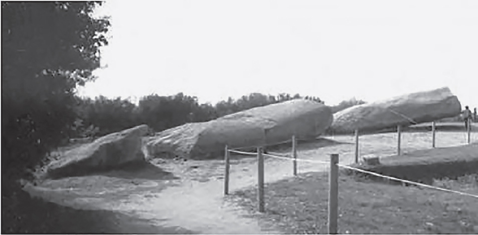
Fig. 11.10. Grand Menhir Brisé was broken into four pieces, perhaps by seismic activity (photo: Ros Strong)
The assumption that the quakes were generated by the movement of the faults explains why 90 percent of the dolmens and their corridors of the south Morbihan are oriented in the same direction as the faults. Consequently, their roof slabs are parallel, with only a slight difference, to the directions of the epicenters, which are all located on faults. In the eight epicenters of the region, five are oriented in the same direction, 52.4° northeast on average, which supposes the existence of an enormous, deep transversal fault. By extending this line to the southwest, we arrive at the location of the Grand Menhir Brisé and the Table des Marchands.
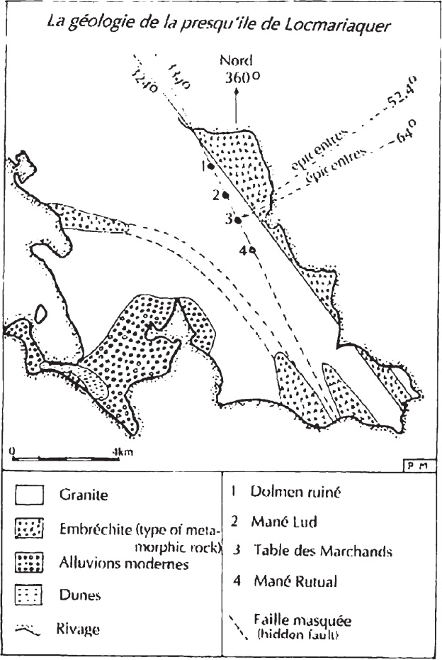
Fig. 11.11. The geology of the Locmariaquer Peninsula
In figure 11.11, note the fault at 324°, which is practically perpendicular to the five epicenters at 52.4° northeast. The difference is 88.4°, nearly a right angle. The line of four dolmens at 334° east is slightly shifted in relation to this fault, but it is also on a fault, partly hidden, that rejoins the first to the north. Mereaux notes, “We can affirm that the place where our four dolmens are placed must have been shaken in a remarkable manner during most all of the quakes of the region and that the heavy tables of these monuments with their dizzying overhangs must have devilishly balanced on their three feet, at the slightest shock. As an earthquake observation station, we could not do better today.”
Chapter VI—Un Calendrier Sismique?
(A Seismic Calendar?)
All those interested in the Breton megalithic monuments, writes Mereaux, inevitably speak of their orientation, which in their view can only be astronomical. This is based on the direction of the couloir (passage, corridor), but no one looks at the orientation of certain dalles de couverture (covering slabs) and also certain uprights. The axis of the Table des Marchands is oriented to exactly 324°, in the same direction as the fault, which is only 175 meters away. It would vibrate more in its length and in the direction of the overhang during an earthquake.
The orientation of Mané Lud and Mané Rutual toward the spring and fall equinoxes and the winter solstice could have served as a provisional solar calendar to determine the beginning, middle, and end of the quake cycle. The astronomical orientation is but one element in the chambers’ function. The roof slabs of these three dolmens are broken, either by man or an earthquake more violent than others. However, the faces of the ruptures do not appear to be intentional. The break is ras de (flush) with certain pointed uprights, which could have resulted from the slabs being pounded during an earthquake. The piece of the Table des Marchands that was transported to Gavrinis poses a problem. Mereaux could not find an example of intentional débitage (cutting).
The moon is important. The Table des Marchands is famous for its dalle de chevet (headstone), which for many past authors represented ripe ears of grain, bent under the sun. This ogival shape was also the symbol of the Mother Goddess, dear to certain “idol maniacs,” who find religion in every stone! Some say that the headstone is an equinoctial and solstitial calendar.
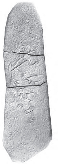
Fig. 11.12. Composite model of the three pieces of the capstone from the Table des Marchands (photo: Carnac Museum of Prehistory)
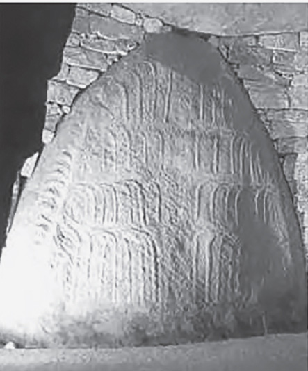
Fig. 11.13. The dalle de chevet, or headstone, of the Table des Marchands
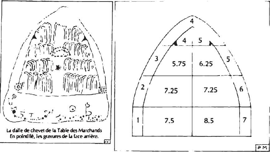
Fig. 11.14. Drawing of the dalle de chevet of the Table des Marchands, with dotted lines to show markings on the reverse side (left); diagram showing number of “crooks” (right)
In figure 11.14, note that the lower four sections of “crooks” add up to between 28.5 and 31 (the small marks on the left and right of each row count as one half) and that the two top sections add up to 9. Mereaux includes complex calculations featuring the importance of nine in relation to the minimum and maximum declinations of the sunrise and sunset at the equinox and solstice. All of these calculations are only for the area of Locmariaquer and Carnac, between 47° and 48° north latitude. He concludes, “There thus exists in this system, a second key which permits us to determine the moment when the full moon and its perigee coincide, which was an earthquake predictor.”
Mereaux has examined the mold of the headstone of the Table des Marchands in the Carnac Museum of Prehistory carefully and found some eroded engravings with possible meanings. He also detected carvings on the back that have possible solar and lunar themes. He noted a cupule in the top surface, previously unreported, that also could have significance.
To Mereaux, it seemed likely that the three dolmens were a veritable observation station to predict earthquakes. Mané Lud and Mané Rutual alerted to the beginning and end of the seismic period. The Table des Marchands provided a finer regulation. He emphasizes that he only writes about what he knows well.
Over a thirty-year period I have gone to the southern Morbihan at least forty times, and I think that only now am I beginning to see a little more clearly and to understand certain things that were previously inconceivable. I now devote, for example, more than ten days to the study of a single dolmen before arriving at a satisfactory explanation of the carvings on it. . . . To return to the question of whether the dolmens were with or without a tumulus, it is certain that the three dolmens never could have served as an observatory if they were buried in earth or stones at the time of their construction.
Chapter VII—L’ídolomanie Archéologique ou le Funeste Destin des Idoles Dépecées
(Idolomaniac Archaeology or the Tragic Fate of Dismembered Idols)
Mereaux disagrees with the position of Jean l’Helgouach, head of research at France’s National Centre of Scientific Research, that the “grand theme of the neolithic idols was in a form specific to the local population of the fifth millennium BC.” l’Helgouach proposed that the “idols” were raised up, then pulled down and broken in pieces to be used for other dolmens.
The Grand Menhir Brisé was broken into four pieces. The total length had been twenty meters, weighing approximately 347 tons. When we contemplate the scale of these four pieces, we have doubts. How can we think this destruction was due to deliberate human activity? There are no marks that could indicate purposeful cutting (and they would have to show). Mereaux believes that this destruction had to be caused by seismic activity, and he provides details to support this opinion.
Chapter VIII—Un Pole Nord qui Se Balade et des Étoiles qui Se Promènent
(A North Pole that Wanders and Stars that Take a Walk)
We all have read claims that prehistoric people frequently recorded on the Earth’s surface the constellations that were useful to repérer (mark) the geographic north, and these authors draw conclusions about the astronomical knowledge of those people. This frequently concerns the Grande Ourse (Big Bear or Big Dipper), but mostly the Petite Ourse (Little Bear or Little Dipper) with its polar star. They tell us that this constellation was often represented on the Earth by menhirs or even carved on certain monuments constructed seven or eight thousand years ago, since it indicated north at that time. This is a stupid mistake and is false! We are told that often during the Neolithic era the geographic north was repéré (located) on the star Alpha, also called Thuban, in the constellation Draco. But this, too, is not altogether true.
We must remember that each hemisphere of the Earth really has two poles, not just one. The first, the geographic pole, defines the axis of rotation and is perpendicular to the plane of the equator. This axis is stable to within a few meters. The second pole of each hemisphere is perpendicular to the ecliptic. It actually makes a 23.45° angle to the plane of the equator in the Earth’s revolution around the sun. But the geographic pole turns equally around the axis of the ecliptic, making the complete journey, known as the precession of the equinoxes, in about 25,800 years.
In addition, the obliquity of the plane of the ecliptic in relation to the plane of the equator has also varied slightly in the course of millennia by a bit more than 10° every thousand years, and the angle formed by these planes attained a value of 24.36° about five thousand years ago, a difference of nearly 1° compared to the angle measured today. This means that the actual North Pole is thus displaced among the constellations and that the Pole Star was not always polar. Figure 11.15 helps to visualize this phenomenon. The curve indicates the trajectory of our North Pole in relation to the stars, going from 1990 back to the year 5332 BCE. To be “polar” at a given era, the star should be on or near this curve, because, viewed from the Earth, it seemed to turn around the real North Pole, at a certain distance, and to indicate a different north at each time.
It is important to note that the star Thuban indicated north for only a few centuries before and after 2666 BCE but was not the Pole Star throughout the Neolithic era. In the period around 4960 BCE, the star number 5635 north of the constellation Bouvier was positioned to be the Pole Star. This was also a period of megalith building, as evidenced by carbon dating.
During this same time period (circa 4960 BCE), it was also possible to track lunar events, rising and setting, and the major and minor extremes, using only the four stars Vega, Arcturus, Procyon, and Capella. This was possible only in the Carnac region (47.6° north), and Mereaux suggests that this may have been the astronomic base for establishing a system for megalithic construction.
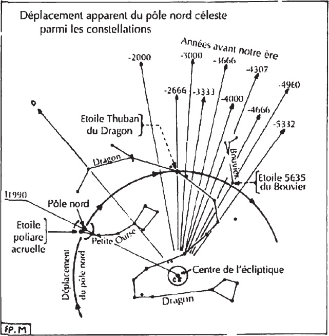
Fig. 11.15. Apparent displacement of the celestial North Pole among constellations (Mereaux 1992, 85)

Fig. 11.16. Geographic location of the Men Milen menhir
Chapter IX—Un Chat Noir Énigmatique Qui Joue au Geometre
(An Enigmatic Black Cat Who Plays at Geometry)
The black cat refers to a small statue at the center of an ancient crossroad, where three roads met, in an area known as Chat Noir. It came to Mereaux’s attention when it was vandalized in 1989. Nearby is a small menhir, only three meters high, known as Men Milen, which can mean “yellow stone,” perhaps because of its lichen covering. He noticed three other stones with the same name that are on an alignment to the Grand Menhir Brisé. Note that crossroads have a universal symbolism in all traditions, places where we find market crosses, chapels, and shrines.
In drawing a circle with a radius of 1.5 kilometers around Men Milen, we find sixty-nine dolmens, intact, ruined, or restored, almost three per square kilometer, the highest density in the whole region. Pursuing ancient language, Mereaux found a linguistic relationship to Milen in trèfle—trois feuilles (three leaves). He noted the angles of the roads that go to significant locations, some with a possible linguistic connection.
An allée coudée is a special type of dolmen: the corridor changes direction and slightly enlarges to form a chamber, sometimes separated from the corridor by an upright. I know of only six in this area; the best known is Allée Coudée les Pierre Plats. The others are only rarely visited. They all have two points in common: they are “bent,” and they have carvings that resemble each other. Diagrams of four of these dolmens are shown in figure 11.18.

Fig. 11.17. Entrance to the Allée Coudée les Pierre Plats
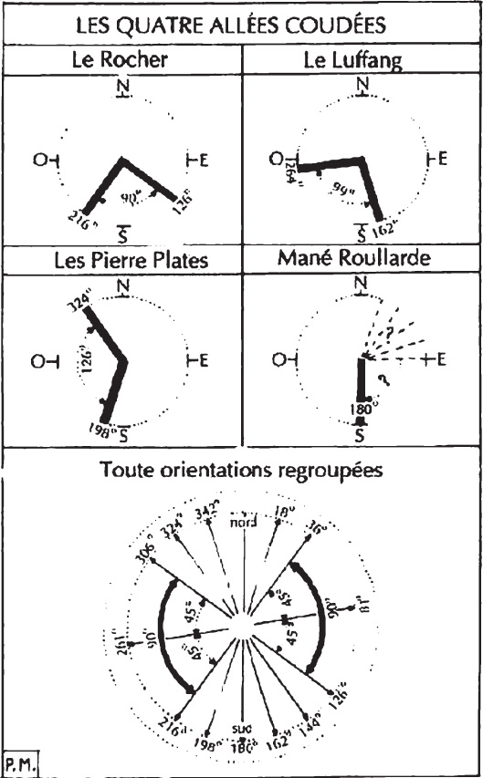
Fig. 11.18. Diagrams showing the orientation of four of the “bentcorridor” dolmens
This chapter contains a great deal of complex geometry and astronomy that relates to many coincidences, especially as Mereaux stresses the importance of the number 9. After hours of reflection and examining all possible solutions, he was not able to find the exact usage of all this geometry but encourages others to continue.
Chapter X—Une Charrue qui Se Balance
(A Plow that Balances)
One of the most celebrated motifs still visible in the Breton monuments is the one called hache-charrue, or the plowshare. There is a magnificent specimen on the underside of the roof slab at the Table des Marchands. In southern Brittany we find only ten megaliths with this design, but of two distinctly different types.
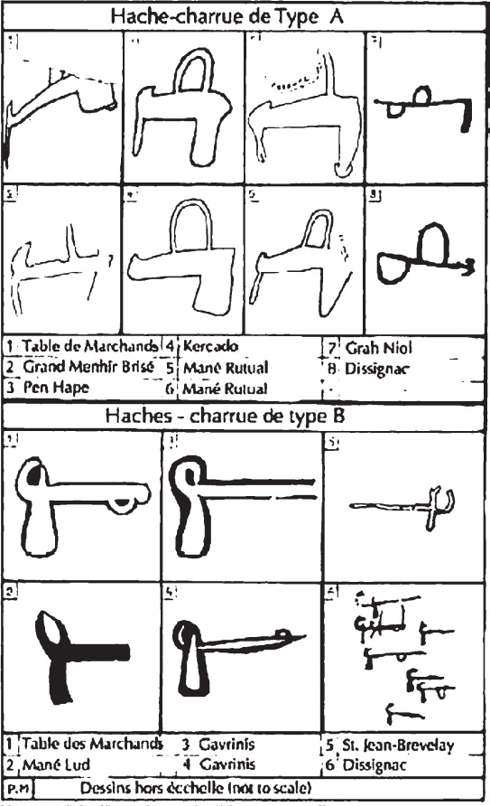
Fig. 11.19. Two types of plowshare, or axe-plow, designs from dolmens
Some dolmens have both types, such as the original roof of the Table des Marchands, a piece of which was ultimately transported to Gavrinis. In one of the dolmens of Dissignac, near St. Nazaire (to the south, not in the Morbihan area), there are eight of these motifs; also two crook motifs.
It is significant to note that megalithic monuments “decorated” with carvings are numerous throughout Western Europe, Scandinavia, Portugal, the United Kingdom, and Ireland, but nowhere else but in Armorique (Brittany) and principally around the Gulf of Morbihan do we find this particular motif. We can rightly ask if it is really a plow. Mereaux quotes from many authors and archaeologists who express a variety of opinions. Plows were made entirely of wood; could the small stone axes have served as plowshares? There is also a question of whether there was agriculture at this period. Pollen analysis shows evidence of some cereal grains about 3000 BCE, but not before.
Of the charrues in the interior of the dolmens, most are on the ceiling. There are only two dolmens, the Table des Marchands and Dissignac, that have both A and B types. In both of these, they are carved practically perpendicular to each other, one horizontal, one vertical. In all cases but one (Kercado), all the type B are vertical and all type A are horizontal! Mereaux began to think of an entirely different usage. He noted that all the menhirs except one have, or had, a corridor. He also noted that in five of the ten megaliths gold was found, either as a thread or wire or nugget, and in small thin strips several centimeters long, cut in a sawtooth pattern and sometimes rolled in a tube, probably as ornaments. There was native gold in Brittany—nuggets found in riverbanks—and the use of gold began in only 2000 BCE, two millennia after construction of the earliest megaliths. Mereaux wonders if all this represented some sort of primitive electroscope.
In examining earthquake activity in the region, Mereaux names eight principal epicenters identified since 1900. Putting them on a map, he finds a relationship of each to the ten megaliths. For instance, Dissignac is situated on an enormous fault, almost rectilinear, that goes through significant locations, one having an esoteric reputation, the isle of Dumet.
He points out that a very hard stone would be needed to make a plowshare and that flint is very scarce in Brittany, found only in small nodules on beaches. Most stone axes in the Carnac Museum of Prehistory are small: four centimeters, a few larger at fifteen to twenty-two centimeters. They are polished and could not be plowshares. They show little or no wear. What other purpose could they have had?
Mereaux made two small models using materials available in the Neolithic era, wood and stone. He made models of type A and type B plowshares (figures 11.20 and 11.21) and suspended them on a bracket (a base with a branch). He inserted a small, thin piece of flint on the top of the arm, a bearing with reduced friction, because the flint has a knife edge at its upper side. It is very simple to use.
All of these “plows” are really balanciers (pendulums) that are very well balanced. When one or the other is suspended by its upper hoop on the flint piece at the end of the branch, each lateral shock on the block serving as the pedestal puts the pendulum in movement in the same vertical line, and the amplitude of the balancement (swing) is proportional to the intensity of each shock.
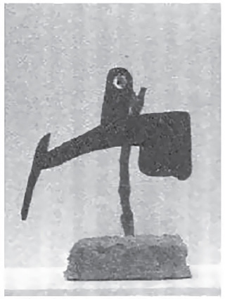
Fig. 11.20. Model of type A plowshare, or axe-plow
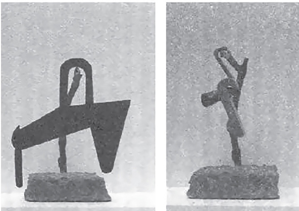
Fig. 11.21. Models of type A and B plowshares, or axe-plows
Mereaux points out that the soc (plowshare) on the carvings of both these “plows” has a strange protuberance on the lower part. He feels that there was a small counterweight (in stone?) added at the end to ensure a better balance.
Mereaux made fifty trials on the same bracket, each trial shifting the pedestal several centimeters with each blow. He observed that the movements lasted twelve to fifteen minutes before a complete stop. Spreading a layer of fine dry sand, slightly concave, just under the tail of the pendulum—the sand is in this way lightly grazed—a line more or less long, and almost straight, is traced, directly proportionate to the shaking of the base or of the earth. The upper hook situated above the tail can also serve to accroché (attach) a small mass so that this tail can precisely skim the sand spread underneath. The system is thus more or less adjustable.
The whole of this appliance constitutes a seismograph (sismometer, sismoscope, or sismographe, whatever we want to call it), permitting us to see the intensity of an earthquake! This could detect the slightest movements, barely felt by humans, especially near the epicenters. After many tests Mereaux determined that with the same force of the blow, the type B device, with 102 oscillations per minute, stops after eighteen minutes, while the type A device, with 76 oscillations, stops after thirteen minutes, which shows that the type B device is more sensitive. With a very faint blow, the type B device balances for nine minutes and the type A for just four.
Perhaps more important in the case of a very violent shock, the type B device unhooks from the bracket, but not the type A, which has a closed loop. With a freshly cut branch, the movement would be greater and last longer. Finally, Mereaux tried this apparatus outdoors, but it was impossible, as it was affected by the slightest breeze. So one thinks of the interior chambers of the dolmens, especially those that have the carvings. In his view, that is the reason sixteen of the twenty are sculpted in this location.
Chapter XI—Du “Jus” Dans les Cailloux!
(“Juice” [Electricity] in the Stones!)
There are many approaches open to those who are interested in megaliths. One can buy tourist guides, visit, then buy books on the subject, although some are vague, and most add to the confusion. Mereaux ridicules the esoteric groups who study the auras, vibrations, and grid systems. He advises participation in a dig and patient observation but cautions that official digs use only the meter stick, compass, and theodolite. He reminds the investigator that not only dimensions can be measured around a dolmen.
When Mereaux went on a “megalithic” expedition, he had with him:
- A magnetometer of his own construction permitting measurements of the Earth’s magnetic variations. It was basically for the specialist, a Schmidt balance but with improved precision to permit differential measurements.
- An adjustable square with two movable branches (legs) of his own construction, serving to verify the angles that were inaccessible in a vertical plan.
- A precision optical instrument (un mesureur d’angle optique de precision) to establish the height of the sun, replacing a sextant.
- Three compasses with mirrors.
- A highly precise Japanese voltmeter, battery operated, sensitive to ten-thousandths of a volt, and with numerical indications.
- Ten cables, ten meters long, with weak electrical resistance, with plugs and couplings.
- Ten copper probes of his own construction with an interchangeable connection system.
- One hundred meters of nylon cord and a dozen small metal stakes.
- A precision level and a leveling staff.
- A series of tools: geologist’s hammer, hatchet, knife, pruning shears, brush, box of chalk, shovel, measuring tape, two halogen lamps, two cameras (one classic, one instant Polaroid model).
Mereaux writes, “When I am on the site and the equipment in place, I think of absolutely nothing. I simply recover the various measurements furnished by these instruments, in their cold rigor, whether it is gammas, millivolts or degrees of an angle. I then write them on pre-printed report forms that I have devised. I urge researchers to create their own. It is only after careful examination of these reports that I draw undeniable conclusions.”
Mereaux affirms that he has never read, on any of his instruments, any connection, not even a distant one, with any religion or anything metaphysical. He believes only what he sees. He has studied more than twenty megaliths in the region extensively, but reports mostly on just a few. He describes in detail how he sets up his probes for voltmeter readings, inside, outside, and on top of the dolmen, and observes that when taking readings for the whole day he notices a gradual drop in voltage from 9:30 a.m. to noon, then a gradual rise in the afternoon. A heavy rain cloud instantly dropped the voltage dramatically. The probe out in the field, perhaps fifteen meters away, registers very low readings most of the time. His magnetometer registers differences of the vertical component of the Earth’s magnetic field, often very fast. These variations are related to sunlight and also the sunspot cycle of eleven years. They are strong about 6 a.m. and 6 p.m. but diminish at noon. The horizontal component shows little variation and so is of no interest to him, thus his instrument is constructed to show only the vertical component. All measurements are in gammas (units of magnetic flux density).
PART II
The voltage and magnetic variation are related. Mereaux mentions the simple phenomenon of electrical induction confirmed by André-Marie Ampère and Michael Faraday. “The dolmen behaves practically as a bobine (coil), an electrician would say solenoid, in which currents are induced, provoked by the variations, weaker or stronger, of the surrounding magnetic field. But these phenomena are not produced with any intensity unless the dolmen is constructed with crystalline rocks rich in quartz, such as granite. For limestone, basalt, and sandstone, for example, the observed values are feeble or almost non-existent. Thus it is the granite that is important and I will return to that.”
He wondered if the orientation of the roof slab could have had any influence and discovered it did.
Dolmen Orientation Voltage
Mané Lud: 81° northeast, 38 millivolts
Mané Rutual: 117° southeast, 138 millivolts
Mané Kerioned: 189° southwest, 245 millivolts
Mereaux writes, “That is to say that the voltage becomes proportionally stronger as the orientation of the roof slab comes closest to the meridian of the magnetic North-South, or in other words as these slabs become more parallel to the line.” He has verified similar phenomena, not always identical, but unique in those structures that have or had carvings!
Mereaux began a series of experiments by measuring menhirs. He chose the Géant du Manio, one of the largest in the region, about six meters tall and more or less rectangular, with the narrow faces oriented north-south. He planted four of the probes touching the base and others spread out every two meters, noting variations and finding that the extremes repeated every seventy minutes, within a variation of two or three minutes. On a cloudy day the voltage was much lower. Thus, at the base of the menhir there is a zone of regular pulsations, positive and negative, and it is surrounded at about three meters distance by another zone, fairly stable and weak, but entirely negative. At twelve meters away there is nothing; the ground is neutral. He has no logical explanation, but the menhir does charge and discharge regularly. He needed more equipment to measure a number of spots at the same time.
Measurements on five of the standing stones in one of the alignments at the Grand Ménec site produced astounding results, readings of up to 1.9 volts variation between the top and bottom of a three-meter stone. The voltage diminished as a stone was farther away from its position as part of a cromlech (circle) and as the stones grew smaller. There was less fluctuation in relation to sunlight. Mereaux says, “In my opinion, it is very possible that the west cromlech was a kind of condenser, I would even say more of a concentrator, as long as this does not mean the usage of electricity.”
All of the alignments of Grand Ménec and also some other alignments are found on an enormous geological platform composed essentially of granulite grenue (a sort of granite with very small crystals) without a surface fault. The topsoil layer is very thin, and most of the standing stones are really “placed” on the granular subsurface. These menhirs are thus relatively unstable. Mereaux explains that the composition of granite is usually feldspar, 60 percent; quartz, 25 percent; mica (black and white), 5 percent; magnetite, 4 percent; and other minerals, 6 percent. This average composition can vary greatly from one location to another, and certain granites can contain up to 15 percent of mica and 30 percent of magnetite.
But quartz, like other crystals, is piezoelectric, which is to say it generates electricity when it is compressed and when it is subjected to shocks or vibrations. So in simple terms, we find both electricity and magnetism in granite at the same time. The Grand Menhir Brisé, when standing, with its volume of 134 cubic meters, could theoretically create around it, at a distance of one meter, a magnetic field of 134,000 gammas, which is close to one-third of the Earth’s magnetic field. Since granite is not homogenous and there must be some loss, in reality, the field must be about 1,800 to 2,000 gammas. It is enough to deflect a compass. So the question is, What happens in an area of thousands of menhirs? It is a fact that the menhirs attract lightning. Mereaux gives technical explanations of the electric and magnetic phenomena and their possible interaction with the stones.
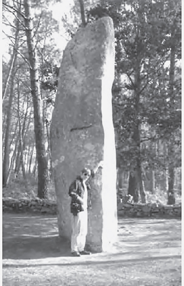
Fig. 11.22. The Géant du Manio (photo: Ros Strong)
What is important, writes Mereaux, is that all these phenomena exist and are measurable, if one goes to the pains of going to the site. In brief:
- The magnetite contained in the granite, often in great quantity, is a natural magnet that creates around it a certain magnetic field.
- The quartz in granite, during shocks and vibrations caused by even tiny earthquakes, generates electricity, which also creates another magnetic field, which can become important, even when the shocks are not felt by the human body.
- The atmospheric factors—clouds, magnetic storms, and lightning—intervene equally, whether from the point of view of electricity or magnetism.
- A menhir acts a little like an accumulator that charges and discharges itself, and a dolmen acts as a coil, much as a cromlech is probably a sort of concentrator.
Chapter XII—Un Cocktail de Feu, de Haches et de Serpents . . . et Un Livre que Personne Ne Lit
(A Cocktail of Fire, of Axes, and of Serpents . . . and a Book that No One Reads)
When the Neolithic Bretons worked the flint nodules they must have inevitably noticed that sparks flew. The stone thus “contained” fire, and it seems evident they would see an analogy with lightning. They might then infer a notion of something sacred (in the old sense of the Latin sacer, “that which cannot be touched without being sullied”).
Citing the 1930 Carnac Museum catalogue, Mereaux quotes Zacharie Le Rouzic (1864–1939), who was the chief investigator, excavator, and then conservator of the museum. Quitting school at age ten to work for the Scottish archaeologist James Miln, who grew to trust him, Le Rouzic ultimately was responsible for much of what we know about this subject today. Le Rouzic wrote:
Even today in some Catholic churches, one uses a briquette (a special piece of steel) and a flint flake to light the sacred flame, which burns day and night in front of the main altar. The sacred flame and ritual must be pure, and to be pure, it must come out of the stone . . . since the beginning of Christianity the sacred flame is extinguished at the Maundy-Thursday mass and relit at the Holy Saturday service, and by this primitive means the priest of Carnac lit the sacred fire. . . . This same flint flake, if picked up outside the church would undeniably be classified as a projectile point.
The notion of relationship between stone and fire, or better yet, between axe and foudre—thunder or lightning—is found in practically all traditions. The axe is in fact a symbol of foudre, and curiously, by a phenomenon of inversion, it also serves as a protection against it. In Brittany, prehistoric stone axes found in the fields by farmers had the reputation of possessing a mysterious power. They called them men gurun, stones of thunder. Not only did they protect homes against lightning when buried in the ground, but they were also used, by boiling them in water, to help bring back the flow of milk to cows that had gone dry.
In certain regions, oral tradition says that thunder falls in two ways, “in fire” and “in stone.” The first burns, the second breaks (brise). Mereaux believes this also explains the symbolism of the numerous superb “votive” ceremonial axes, sometimes of a large size and often of a green color, that have been discovered all over the world and certainly were never used for hunting, war, or agriculture.
Three hundred meters from the Géant du Manio is a four-meter-tall menhir. At its base, the soil was disturbed, and, in 1922, carvings of five wavy lines were uncovered.
Mereaux feels they represent serpents. At the base, in the soil at a depth of twenty centimeters, five polished axes were found, four of diorite and one of fibrolite, aligned vertically, cutting edge up. In Gavrinis, he also found three vertical serpents next to three axes, cutting edge up. Also in Gavrinis, he saw other vertical serpents and thirty axes, also edge up, except for two. He refers to them as haches non emmanchées (nonhafted axes). Both motifs are rare, and again, they are found only in the monuments situated near and around the Gulf of Morbihan. Aside from Gavrinis, only eight of these engraved axe motifs have been found.
Mereaux feels that for a brief instant, during a storm, lightning seems to undulate in the sky, like a serpent; one is a symbol of the other. We know that European serpents hibernate in winter, at a depth of ten to twenty-five centimeters. We can see the juxtaposition of elements, having between them an analogous relationship: the stone that contains the fire of the earth and the serpents that are manifested in the fire of the sky. Note the relationship to the electricity between the base and the top of the menhirs at Ménec.
There is a unique dolmen at l’Île Longue at the entrance to the gulf. It is concealed in a partially destroyed cairn and difficult to visit. The corridor is classical, but the chamber is corbelled, the only one in this region and rare in the rest of Armorique. There are five carvings, one no longer visible. Three of the carvings are of special interest.
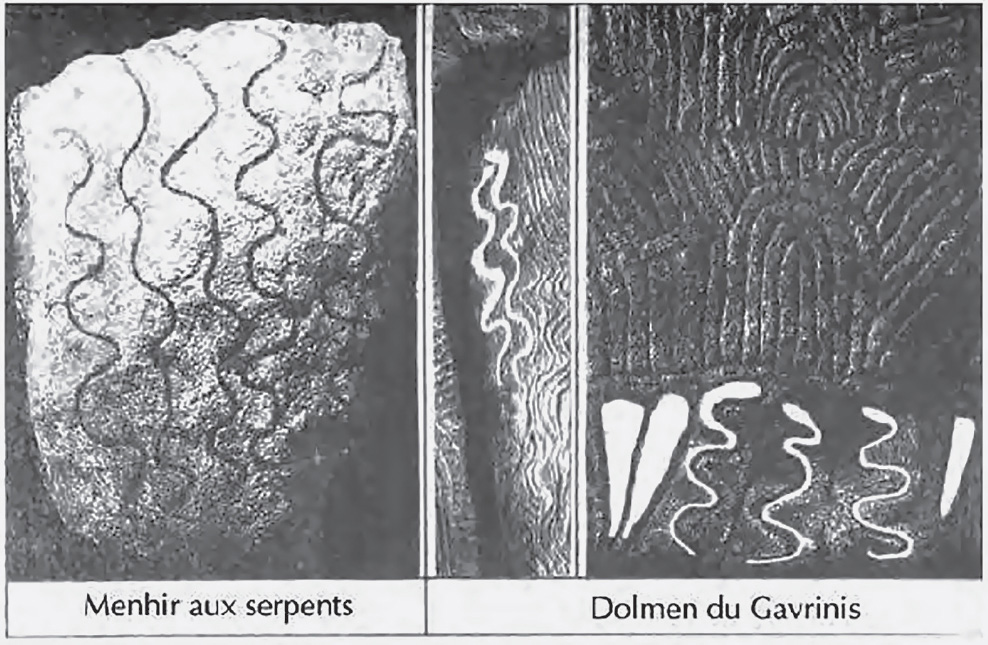
Fig. 11.23. Carvings on the Menhir of the Serpents and details from the dolmen of the island of Gavrinis
The first two carvings are on the underside of the roof slabs of the corridor. Their shape is generally referred to as a shield. Mereaux sees in this a representation of magnetic lines of force. The third figure is well known, and there are varied interpretations of this reversed escutcheon. Some see a shield with two handles, others an idol with hair, and Le Rouzic called it la marmite (the pot).
A friend of Mereaux, Robert Le Cloirec, who worked at the Carnac Museum for fifteen years, sees it as the course of the sun; the base is the night, and the sides represent, respectively, the dawn and twilight (see figure 11.28). The lateral handles symbolize the sun rising in the east and setting in the west, and the two notches indicate the precise moment when the sun was totally visible after the rising and entirely visible before setting. The point on top marks the passage at the zenith, and the exterior fringe, carved all around the top part, between the handles, the solar rays. Mereaux approves of the idea and notes that the fringe is longer near the rising and setting than at the zenith. This design is found in other monuments, sometimes in a simplified form. For instance, this ogival form is found in the chambers of the Table des Marchands, Mané Lud, and Mané Rutual.
Mereaux then turns his attention to one of the most imposing monuments in the Carnac region, the massive tumulus, or chamber, on the small island of Gavrinis near the tip of Locmariaquer in the Gulf of Morbihan.
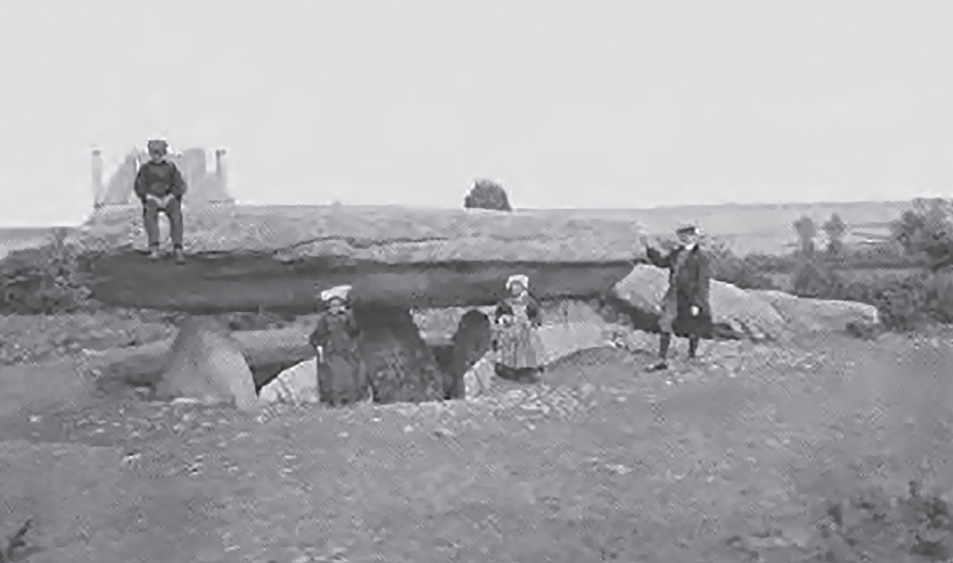
Fig. 11.24. The Table des Marchands (National Geographic, 1923)
There are twenty-nine uprights in the chamber passage at Gavrinis, and Mereaux has indicated those with unique designs that are not in the same style as most. He divides the designs on the uprights into three sections, A-B, B-C, and the chamber.
The seuils (thresholds) divide the areas. He finds great significance in the differences between the uprights with no decoration, those with only gravures diverse (ordinary carvings), and those with motifs encountered elsewhere.
The two blocks of pure quartz, uprights 7 and 11, have very faint traces of carving, but no perceptible images. Mereaux bitterly regrets that we will never know what was carved on them. It is very important that the quartz had to be brought from a distance of ten kilometers. It is much harder than the granite of the immediate region. He feels the chevrons may represent a plus and minus, perhaps the electrical pulsations, while the concentric half ovals may represent an electric or magnetic field. Upright 15, at the right rear of the chamber, is the most interesting, because it has a small triangle with five slightly curved lines emerging from the top. The only such design in the region, it strongly resembles the way we illustrated a comet or meteorite fall in the last century. He relates this to the axe symbol of foudre and the magnetic field of the half ovals. In 1981, he suggested that the magnetic fields produced by standing stones are similar to the fields produced by a magnet (see figure 11.25); later, he was certain, although this opinion is not shared by everyone. He had not done any electric or magnetic measurements at Gavrinis, and he had no plans to do so; he felt there was not a physical phenomenon there. Gavrinis is not a place of experiences; it is a place of knowing and teaching.
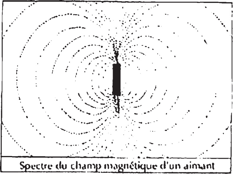
Fig. 11.25. Magnetic fields produced by a magnet
Mereaux did not believe it was a temple or a tomb; it has a menec, a memory. The whole represents something that he would dare to call science, and that was evidently only accessible to initiates, members of a certain elite. This elite, no matter what the form or the level, must have existed in that era, as in all societies, in a kind of intellectual segregation. This splendid dolmen, which Mereaux considers the most beautiful in the world, is a veritable book for those capable of reading it. He finds it impossible to believe that all this was only a graphic expression of a certain spirit of research, pure or fundamental, as we would say today, with no possibility of practical application. This is what he writes about in the following chapters.
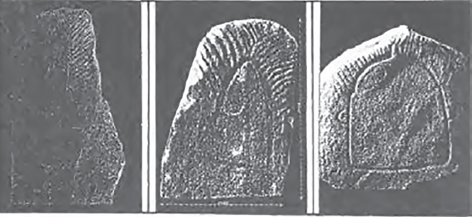
Fig. 11.26. The dolmen on l’Île Longue
Fig. 11.27. Entrance to the chamber of Gavrinis (photo: Ros Strong)
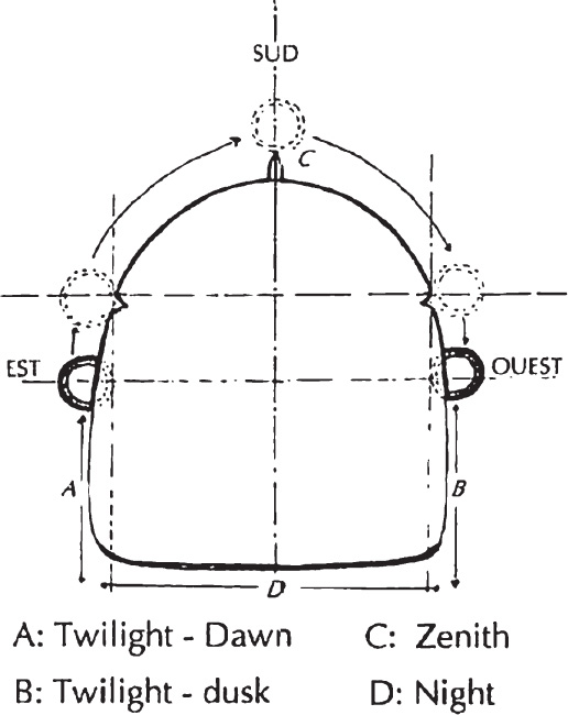
Fig. 11.28. Diagram of the carving from l’Île Longue, which is seen as a calendar marker
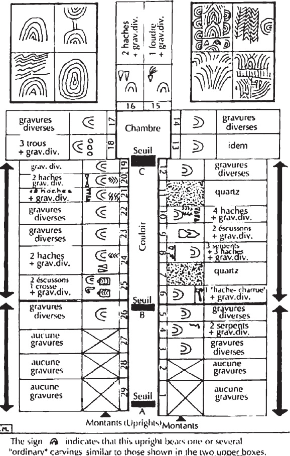
Fig. 11.29. Schematic plan of the dolmen on the island of Gavrinis
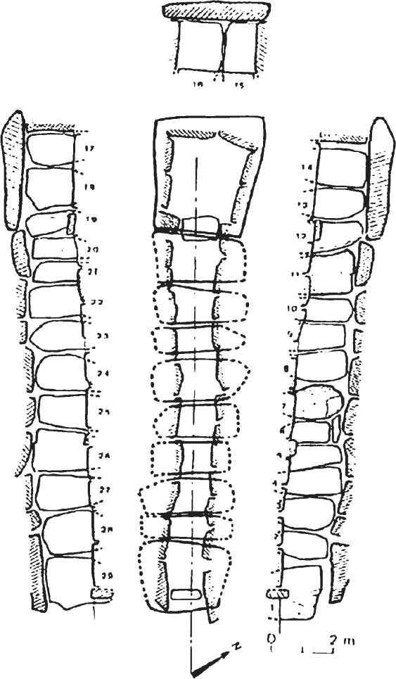
Fig. 11.30. Schematic plan of the chamber of Gavrinis (drawing: Charles-Tanquay Le Roux, 1985)

Fig. 11.31. Carved symbols along the entrance passage in the chamber of Gavrinis (photo: Gwenc’hlan Le Souézec and Jean-Robert Masson)
Chapter XIII—Un Sens Magnétique Mal Connu . . . ou Méconnu
(A Magnetic Sense That Is Poorly Understood . . . or Misunderstood)
In this chapter, Mereaux investigates changes in the Earth’s magnetic field. Based on studies carried on for more than three hundred years, it appears that the field is less intense now. In 2000 BCE, the intensity of the field was almost double that of today. We can estimate that if it declines at the same rate, it will be almost nothing in 1,500 to 2,000 years. The moon also had a much stronger magnetic field and had a number of reversals, the last one well before the historical period.
The normal atmospheric pressure is about one kilogram per square centimeter, and the average individual has a total skin surface of about 1.5 square meters, thus producing a total pressure of fifteen tons! Many people are very sensitive to a modification, even a very slight one, of this pressure and feel a sensation of real comfort or discomfort. We are also sensitive, some more than others, to changes in the oxygen levels at heights of only two thousand meters. This can create heart problems as well. This “mountain illness” is also partly due to the lower atmospheric pressure, which at that altitude is only 78 percent of sea level.
We live in a changing magnetic field, not only that of the Earth but also that from man-made pollution from radio, TV, radar waves, and so forth, plus the enormous amount of iron in buildings, cars, and machines. In the Neolithic era, before the Iron Age, humans were not as “magnetically polluted” as we are now. They were only subjected to the natural magnetism that they were capable of feeling and probably knew how to exploit. Our civilization of iron and magnetic waves has certainly contributed to the degeneration of that faculty, which must have been a kind of sixth sense that still exists in some people today.
The brain is an excellent generator of electric currents and also magnetic fields that, while very weak, are detectable by a magnetometer. The total energy of cerebral metabolism is about twenty watts and that of the whole body is sixty to sixty-six watts, enough to light a bulb! Doctors and biologists know that the slightest movement of contraction produces a weak electric current and, inversely, that a small electrical stimulation produces a contraction. Our brain and body are thus a veritable electromagnetic apparatus, subject to the influence of electricity and magnetism.
Mereaux gives a detailed description of experiments with bacteria in water. They always form bands aligning parallel to the magnetic field, and in a natural environment they orient themselves to the north and south poles, even when killed! They contain minute amounts of magnetite so are literally “living compasses.” Scientists have discovered magnetite in bees, pigeons, some marine mollusks, dolphins, tuna, sea turtles, bats, and some butterflies. In “superior vertebrates,” the ethmoid bone, situated at the root of the nose and riddled with holes, is composed of many cells rich in iron and with nerve endings. This may be where we find the location of the magnetic sense. Unfortunately, very little of this research has been done in France.
Chapter XIV—Une Sience Plus Avancée qu’ On Ne Pourrait le Croire
(A Science More Advanced than We Could Imagine)
Mereaux feels that the Neolithic peoples’ knowledge of the physical world went further than we can imagine and wonders if there are other areas where their knowledge was more advanced than ours; for example, the human body. A newly named discipline called paleopathology deals with the maladies that affected ancient people. He is most impressed with the huge amount of evidence of trepanation—surgery on the skull—that has been widely reported in the scientific literature. He suggests that before agreeing to the operation, a patient must have had confidence in the surgeon and the efficacy of some kind of drug or anesthetic. We have all read of the trepanned skulls, sometimes with more than one hole, that showed clear signs of healing, hence recovery. What particularly impressed Mereaux was the fact that some holes were cut after the patient had died of another cause and that the patient had a separate, previously healed hole. This indicates a scientific interest in doing a postmortem examination to learn more. He wants to emphasize that Neolithic man was intelligent, was eager for knowledge, and had scientific curiosity and a spirit for what he calls research.
There have been 240 to 280 generations since that time, and some human biology has been modified. In the Neolithic era and before, man lived in nature, was an intrinsic part of it. With a very small population density, he didn’t destroy or pollute but lived in harmony with nature. His senses, which he probably needed for survival, were sharper than ours.
Did Neolithic man possess faculties we no longer have? Many have asked that question. Mereaux discusses genes and causes for mutations such as ionizing radiation, x-rays, chemicals, and ultraviolet radiation. He would add magnetic fields and telluric lines. Rather than say the early inhabitants of the region were mutants, he says instead, “It is we of the present time who are a kind of mutant, in degeneration, in the sense that we have completely lost certain faculties because of non-use, or better, that these faculties perhaps still exist in us, but in our line of evolution, we have lost the method of using it. And I also think that there exist among us rare individuals who have instinctively recovered the way to use it, even if they are not always aware of it” (Mereaux 1992, 194).
Returning once more to the dolmen of Gavrinis and stopping at the threshold and looking up, we see two signs of a U form. These are the two designs we see first because the uprights on both sides have no decorations. These are placed over the door to symbolize all that we will see in the dolmen. The U form reminds Mereaux of the curved wand used by some radiesthésists (dowsers). Considering how much these people knew, it would not be surprising if they used this instrument to detect magnetic fields because, contrary to what is generally believed, the dowser’s wand is not influenced by underground water but by variations in the Earth’s magnetic field.
As a key reference source Mereaux cites Yves Rocard, who died in 1992 at almost ninety years old. A physicist, mathematician of international renown, member of the French Atomic Energy Commission and of the National Center of Scientific Research, and former director of the physics laboratory of l’École Normale Supérieure, Rocard had published three articles since 1964 in high-level journals. In his last book, La Science et les Sourciers (Science and Dowsers), in 1989, he relates all the trials he did and demonstrates irrefutably that it is not the “waves” emitted by the water that guide a dowser but that the dowser is sensitive to variations in the Earth’s magnetic field. Simply put: all geological irregularities cause a local modification of this field and produce telluric currents that cause a nerve impulse and a light muscular contraction in the dowser. It is this unconscious muscular reaction that moves the wand or pendulum, and it is not these instruments that miraculously put themselves in motion by the effect of mysterious effluvium. The good dowser often discovers water but not always. Why? Because underground water always chooses the easiest path in the geological seam and thus has a tendency to accumulate or circulate in underground faults. According to Rocard, it appears that certain people can sense a local variation of only thirty gammas, which is very small and demonstrates a high sensitivity.
Mereaux writes, “Rocard’s book is difficult to understand, full of incomprehensible formulas (for the average person), but they are needed for the demonstration of certain phenomena.” Mereaux worked very hard to verify all the results and found only one tiny error, probably a typo! By what physiological process does the dowser react to the magnetic variation? This is what Rocard tried to put in evidence by a variety of experiments on himself, his family, and even his dog. They were conducted with scientific rigor, with equipment of his own construction and a magnetometer.
Mereaux redid many of Rocard’s tests and obtained identical results, with very slight differences due to the variation in magnetic fields at different locations. He writes, “Yves Rocard arrived at the conclusion in 1983 that we possess centers sensitive to magnetism in the crook of the knee, in the arch of the eyebrow, the heels and the neck, and this sensitivity can have as a source at these places, only crystals of magnetite, as in bacteria, algae, pigeons and other animals and higher mammals. He is on guard against false dowsers, braggarts and masqueraders, where the object is to exploit the immeasurable human credulity by pretending to find lost objects, even lost people, using photos, hair and even road maps.”
Rocard laments that there is a form of censure of knowledge when dowsing is a part of an experiment. The research is buried as though it were scandalous. Even if an interesting experiment is done, it is impossible for it to reach the conventional scientific community.
Mereaux says, “The stick of supple wood permits the detection of a magnetic field or local variation by the intermediary of localized receptors in the human body. And our organism is thus an ‘anthropomagnetometer,’ a word created in 1968 by the physicist Zaboj Harvalik who emigrated to the U.S. and was scientific consultant to the Advanced Materials Concepts Agency, a branch of the American Army” (Mereaux 1992, 200). Of all the types of sticks used by the dowsers (he does not speak of the pendulum), Mereaux is most interested in the wooden stick. No one knows when this instrument was first used; some authors think the Chinese did before 2000 BCE, but we can’t be sure, and we could, if we want, go back to Moses on Mount Horeb, where he made water flow from a rock by hitting it with his wand. Figure 11.32 shows the U forms of the joug (yoke) symbols of Mané Lud and Gavrinis, which could easily be made from a thin, supple hazel twig. Difficult for you to admit? Perhaps, but there is something else.
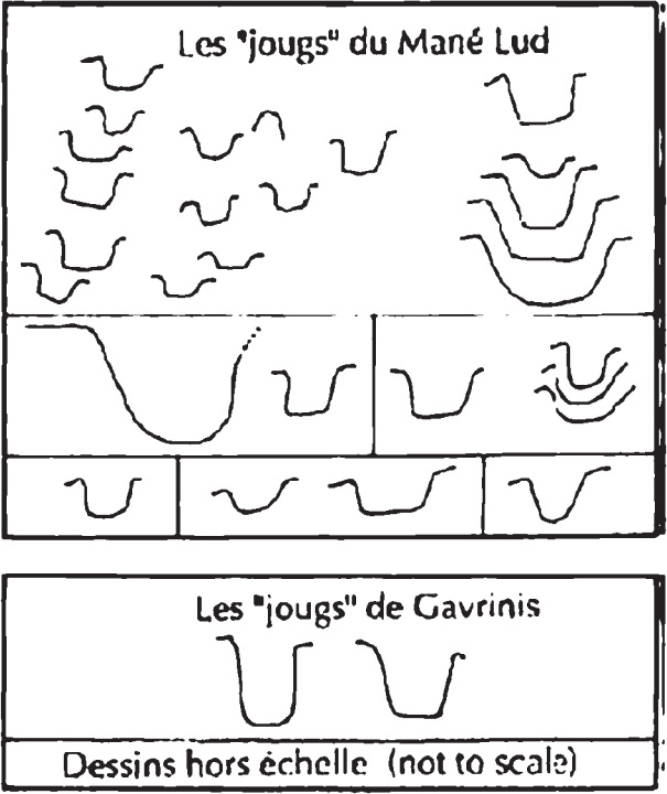
Fig. 11.32. The yoke symbols from Mané Lud and Gavrinis
The roof slab of Gavrinis is a piece of the one at the Table des Marchands (see figure 11.33), and the designs continue from one to the other. Note the form circled in figure 11.34.
In Mereaux’s opinion, the resemblance to a dowser’s stick is striking—forked, as those used today. If we put the two parts together, this “instrumental” stick is in its right place, in the middle of the two haches-charrue, which he sees as a seismograph, and bordered by two bovines. Images of bovines are totally unknown in all of the Western European megaliths. Between the North Cape of Norway and Gibraltar, we find only three representations, and all three are in Locmariaquer. Two are on this stone, and the other is on the stone “model” of Mané-er-H’roeck. There must be a connection with the whole megalithic area here. Why is it impossible to tell if these bovines are male or female? Mereaux believes that they can only be a stylized design of the bull, eternal symbol of virility and fecundity.
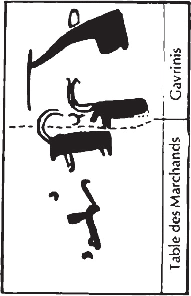
Fig. 11.33. The capstones from the Table des Marchands and Gavrinis shown in their original arrangement

Fig. 11.34. Detail of the capstone from Gavrinis
In a tumulus called the Petit-Mont at Arzon, one of the uprights has a pair of feet, about which much has been written (see figure 11.35). In his previous book, Mereaux explored the possible linguistic connection between sol (ground, earth) and soleil (sun) and plantes des pieds (footprints). By planting his feet on the Earth, could a human form a link between the Earth’s magnetism and the sun?
It was Rocard, years later, who clarified the question. To study the magnetic sensitivity of the human foot, he used very tiny ferrite magnets, two millimeters on each side, and found that the principal center is situated in the center and six centimeters in front of the hump of the heel bone (where all the body weight rests) and less than one centimeter from the sole of the foot. A second center, a little less sensitive, is in the big toe. These two biomagnetic receptors are thus situated only a few millimeters from the Earth for a barefoot human being, where they would be susceptible to being directly influenced by Earth’s normal magnetic field and also by that field produced by masses of granite, superimposed on the geomagnetic field, and which certainly could have become very intense during the vibrations of an earthquake. And the effects must have become more important when these bare feet were placed on the granite slab of a dolmen like that of Mané Lud, for example. As we have seen that the sun has a direct action on geomagnetism, Mereaux believes this demonstrates the relationship between feet, the Earth, and the sun. In addition, two of the designs at Petit-Mont are of a solar wheel, one of which has a diameter of more than fifty centimeters. A physician suggested to Rocard that there are biomagnetic receptors on the sides of the arch of the eyebrow. Note that the ethmoid bone, mentioned earlier, is in the center of these receptors. We can verify that it is the vertical component of the Earth’s field that influences the magnetite in our body and that it is precisely this component that is subject to great variations. Moreover, that is why the sens sourcier (the dowser’s sense) disappears completely in the vicinity of the equator, where this vertical component disappears.
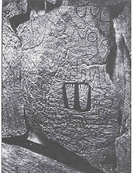
Fig. 11.35. Engraved feet from the chamber of the Petit-Mont
In the dolmen of Petit-Mont there are also many chevrons, yokes, crooks, and a “shouldered idol” accompanied by axes. Mereaux feels that this also can be a livre de magnetisme, a book written in stone, similar to that found on Gavrinis. What he says about the structure on Gavrinis: “This splendid dolmen, which Mereaux considers the most beautiful in the world, is a veritable book for those capable of reading it.”
Mereaux goes into detailed reports of experiments by a medical doctor that prove the various effects of magnets: beneficial effects on the human body: the nervous system, the cardiovascular system, the respiratory system, fractures, inflammation, and so forth. These curative effects of magnetism are not new; he feels that traces can be found in pharaonic Egypt. Still, he cites many examples of false claims by charlatans of the curative power of magnets. The public has been exploited for many years.
Devoting five pages of opinions by a variety of authors as to the true purpose of the megaliths and finding no good single reason, Mereaux expresses skepticism of all the proposals. These range from the ridiculous—extraterrestrials used the alignments to guide them in their search for uranium, or they were once covered by branches and so were related to Algonquian longhouses—to more sober theories by well-known archaeologists such as Jean-Pierre Mohen. In his beautiful volume Le Monde des Mégalithes (The World of Megaliths), Mohen envisions Carnac as a ceremonial center and a witness to the spirituality of our ancestors. Mereaux is particularly annoyed by Jean Markale, who insists on relating everything to the Celts. Mereaux writes:
With many good intentions and imagination, some can perhaps explain only the dolmens, others only the menhirs, but none of these explanations can apply comprehensively to all these types of monuments. It seems evident then that these constructions had other reasons. In my view, only several motives of major importance and in direct relation of one to the other could have been the origin of the conception and the realization of the extraordinary monuments, because, I repeat, it would be absolutely senseless to think they manipulated thousands of tons of stone for only one reason.
We will now examine, point by point, in the simplest way, all that can help guide an argument that I hope is logical. First of all: geometry. It is no longer doubtful that certain megaliths or their placement are based on a fundamental geometry; here are a few examples: The allée coudée of Pierres Plates, constructed on a base of two pentagons, is displaced 18°. The four allées coudées in the region all have characteristics that are purely geometric as are all the multiple angles we find everywhere in the same region. The rectangle of Crucuno is composed of 22 menhirs forming two Pythagorean right triangles of 3-4-5 and exactly oriented to the risings of the sun and moon.
This brings in astronomy that we can believe is manifested in certain terrestrial geometry, at least in part, because it seems that the astronomy was not the main object, but a means permitting the determination of something else (Mereaux 1992).
Mereaux also discusses the work of the Thoms, father and son, whom he admired as researchers, but he disagreed with their conclusions. Unfortunately, Alexander Thom, the father, is no longer here to respond. Mereaux writes, “The work of the Thom family showed after all, that there was manifestly an astronomical intention by the builders of the Breton megalithic monuments, at least for some. But the Thoms only saw pure astronomy, for the prediction of eclipses for example, and nothing else. However, they should have integrated all this in the context of the region, which is exceptional as I have already said.” Mereaux also criticizes Aubrey Burl, whose guidebook of Brittany is aimed at tourists but has many errors, showing that he did not visit many of the sites.
Mereaux quotes the last paragraph of Pierre-Roland Giot’s book Préhistoire de la Bretagne (Prehistory in Brittany): “By all means, the excessive amount of work implied in the placement of the large menhirs or the vast megalithic groups, like the huge tombs, reflects certain characteristics of societies with master builders. Whatever the form, there was an organization with terrific efficiency. And truly, if the occupation with astronomy and even astrology had a large part in the motivation of these builders, it is very possible, as has been suggested, that they constituted a caste of dowsers, sages, or priests, devoting themselves full time to esoterism and traditional knowledge.”
Mereaux believes he has demonstrated the relationship between the megaliths and the sous-sol (subsoil).
The faults and their orientation; the nature of the earth (granite, quartz etc); the placement and the structure of certain menhirs and dolmens, suggest that they are . . . perhaps not generators or transformers, but at least receptors of energy. This particularly curious south Armorican geology inevitably leads us to take into account the earthquakes that are its normal consequence, with all that implies, again as supplementary secondary effects, magnetic and/or electric.
To repeat briefly: in the geometry, astronomy, geology, earthquakes and electro-magnetic phenomena, I see not only a logical sequence, but also five motifs, which, not taken one by one, but united because they are dependent on each other, seem to me to be the primary reason for the erection of megaliths in the region of Carnac and of Locmariaquer. . . . I say, “the first reason” but what was the final objective? The essential objective was to obtain certain effects on the human body (Mereaux 1992).
Chapter XV—Texte D’entracte . . . et Aussi Mise au Point
(An Interval of Clarification)
Once again, Mereaux gives great credit to Zacharie Le Rouzic, protégé of James Miln, the Scottish archaeologist and founder of the Carnac Museum of Prehistory. When Miln died in 1881, Le Rouzic was only seventeen, but Miln had left him in charge of the museum under the direction of the mayor of Carnac. Le Rouzic became the official conservator of the museum only in 1920 but undertook hundreds of digs and had more than 120 megalithic sites declared historic monuments. He restored 130 sites and wrote 105 works and notes relating to the digs. Mereaux defends his reputation because there has been a tendency of late to refer to the old museum as dusty and of little merit.
Chapter XVI—De l’usage des Pierres et des Trous
(The Use of Stones and Holes)
In 1909, Rouzic wrote a priceless volume recalling all he could gather about legends, ancient customs, and traditions. Much has been written about the folk traditions of young women going to the stones to find a husband, to be able to become pregnant, to have a male child, and so forth. There are many variations, but most involve rubbing against the stone, sitting on it with a bare bottom, or sliding down a stone, sometimes at specific times, often relating to the moon. There are tales of placing a child on a particular stone for a specific ailment. The water collected in depressions on top of the dolmen supposedly had therapeutic effects, and women also rubbed their bellies with the dust of the stones. Many of these notions related to the stones still survive. Mereaux discusses the worldwide prevalence and variety of such myths and quotes some authorities. He writes, “One must ask, as did a humorist in telling about all these fertility practices: “If they never really worked, why continue all this time?”
There are a few “chambered barrows” in the area that have oval holes cut in one of the uprights or in an interior partition. Almost no bones have been found in these, and Mereaux wonders if their construction didn’t have more to do with the special hole called le trou de l’âme (the hole of the soul). He discusses at length the famous Men-an-Tol in Cornwall, which consists of a doughnut-shaped stone set on edge that a person is supposed to crawl through a certain number of times, sometimes in the direction of the sun. For example, children with rickets were passed through three times, then laid on the grass toward the east. It was also good for scrofula, rheumatism, fevers, and spinal problems.
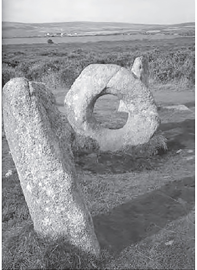
Fig. 11.36. Men-An-Tol, Cornwall, England (photo: John Manley)
Mereaux writes, “What was the effect of a holed stone on the human organism, especially if it was granite? In passing through the hole, one is literally placed in the center of and completely surrounded by the magnetic field, a little like a roast in the microwave. . . . We can also now say that, according to the work of Rocard, it is the vertical component of the geomagnetic field that most affects the human body, and that this influence is greater when it is done laterally.”
Téviec and Hoedic are two small islands off the coast that were still attached to the mainland around 5000 BCE. Some of the earliest tools, small dolmens, menhirs, and burial cists were found with many skeletons. They were from the Mesolithic age, preceding the Neolithic. These people lived a very simple life with a poor diet, yet we must realize they were living at the same time as the beginning of the construction of the megaliths, where the earliest date is 4950 BCE (at Kercado). They had many maladies, some congenital, and often had spinal problems and arthritis. They were short in stature, averaging 1.59 meters for men and 1.51 meters for women. While there are certain traits of their morphology still found in the population today, the average height today is 1.68 meters.
Mereaux writes:
Ce ramassis d’eclopés [this group of cripples] has survived instead of disappearing, and I come back now to the question I asked, perhaps prematurely, in the early pages of the book: “The megalithic builders must have chosen: to survive or to build monuments.” But they did both! Can we then argue that the fact of the construction was absolutely indispensable to the survival of their people or perhaps only a portion of them? Who knows? To choose between survival or astronomy or the absolute cult of the dead, I think the choice is obvious: The megaliths literally materialized a certain vital force, and if we consider their magnetic and electric context, they are then stones for the living (Mereaux 1992).
In discussing the work of several researchers in magnet therapy, Mereaux provides references for those wishing to pursue the subject but warns against self-treatment because the effects are not always beneficial. One pole of the magnet may have an anti-inflammatory effect, but not the opposite pole, and while beneficial results are possible in some precise situations, harm can be done in the hands of an unskilled practitioner.
Mereaux gives details of experiments at l’Unite de Biologie de la Fecondation (the French National Institute of Agronomy, the study of crop production and soil management). They have succeeded in producing a rabbit with no male parent—parthenogenesis! This involved subjecting a freshly removed ovum to an intermittent electric current while in a bath of calcium ions. [This is a poor translation, very complex. —Trans.] Somehow the egg divides. He connects this to the alternating positive and negative currents at some stones; they would have an effect of polarizing and depolarizing the membranes of the egg. If the male spermatozoa were weak, this stimulation would help. Of course, the woman would have to rub herself on the stone after intercourse. Naturally, this hasn’t been verified, but it seems a logical explanation for some of the beliefs.
Mereaux writes:
The fundamental question in your eyes is probably: is all this still functioning today? Perhaps I have not answered all your questions, but nevertheless I think I have introduced all the elements . . . and I leave you to direct your ideas, for or against what I propose. . . . I have had several experiences that I have not written about, and one of them left me with a bad souvenir [memory], because at a given moment my heartbeat, which is normally 63, at rest or standing, went to 85 in five or six minutes and I did not continue. If you want to really “feel” the megaliths, risk doing what I did several times with no danger. In March or September, with a clear sky and as close to the full moon as possible, near midnight, walk barefoot or even totally nude in the rows of menhirs, but not at Grand Menec because the police station is close by and they would not appreciate it! Rather do it at Kermario and for a long moment, lean against the big, squat menhir. . . . I don’t know exactly what you will feel, physically or psychically, because this depends on your organism, but I guarantee that this will at least leave you with a curious and indefinable impression, agreeable or not (Mereaux 1992, 240).
Mereaux cautions against doing it on just any stone in the region, because without doubt this could cause unknown consequences.
Carnac is certainly not the place where we can find a remedy, even psychological . . . and it is thus completely useless to want to stay here because the megalithic monuments are not generators of miraculous cures, except perhaps, one never knows, if one knows exactly the right method . . . but go, in spite of everything, because the area is so lovely—and with a bit of luck you will undoubtedly have the good fortune to see that . . .
| La-bas pres de la dune | Yonder, near the dune | ||||
| Dans les ajoncs bretons | Within the gorse of Brittany | ||||
| La nuit au clair de lune | By night and moonshine | ||||
| Les korrigans dansent en rond. | The dwarfs are dancing in a circle. | ||||
| THEODORE BOTREL (1868–1925) |
SELECTED GLOSSARY
ajoncs: gorse (furze)
Armorique: ancient name for Brittany
coup de foudre: used for both lightning and thunderbolt
crosse: shepherd’s crook or bishop’s crosier
dalle de chevet: headstone
éclair: lightning
faille: fault
hache-charrue: plowshare (literally axe-plow)
hache-emmanche: sleeved or hafted axe
joug: yoke
Kerkado, Kermario: Names of alignments and dolmens
menhir: standing stone
radiesthésist/sourcier: dowser
soc: point of the plow entering the earth
telluric: Of or arising from the earth
telluric lines: lines of the solar spectrum that owe their presence to the absorption of the Earth’s atmosphere
tonnere: thunder
ADDITIONAL MEREAUX TRANSLATIONS
Translated by Shari Kreisberg Therrien (author’s sister)
“Table Des Marchands,” from the National Geographic, 1923
Granite contains up to 25 percent of quartz, and most megalithic monuments from Brittany are of granite, with a few exceptions, some even being entirely in quartz, like this one from Kerbourg, which I spoke of previously, or like certain ones from the dolmen of Gavrinis. Do you see, perhaps, what I am getting at? In addition, granite contains magnetite, the most widespread of the ores of iron, which is a natural magnet, already known to ancient Greeks, therefore creating a magnetic field around it. In simplistic terms, one finds in granite, at the same time, electricity and magnetism!
Journal of Geophysical Research, 1982
In 1979, in the “Mail from Readers” section of the well-known magazine Nature, no. 279–169, one could read a letter from Professor Stuart A. Hoenig, of the University of Arizona (U.S.A.) indicating that he had, in his laboratory, submitted granitic rocks to high pressures and that the rocks emitted particles that were electrically charged before their rupture. He had undertaken these tests in research concerning a possible method of forecasting earthquakes.
Three years later, an article appeared from the radio astronomer James W. Warwick. Six days before the large earthquakes in Chile in May 1960, he had accidentally found a mysterious radio-electric noise recorded by four American telescopes. The noise lasted only ten minutes. He assumed that the source of this noise came from the region in Chile where the earthquake was going to happen. He then proceeded to check the possibility of such a hypothesis in the laboratory. For this purpose, he placed receiving antennas close to the core of the granite, while he submitted the core to a high pressure by means of a hydraulic press. He then observed the emission of an intense radio-electric noise (brought on by the two, magnetic and electric, components), which appeared suddenly when the pressure reached values close to those producing the collapse of the block. Finally, he also observed that there was no radio noise emission when he replaced the granite with materials that had opposite properties to granite, materials that did not have quartz crystals, implying that the piezoelectric effect plays an essential role in this emission.*7
In the former Soviet Union, similar research was undertaken in 1973 by Guennadi A. Sobolev and his collaborators. The Institute of High Pressure Physics of the Academy of Sciences had built an exceptional press that can develop fifty thousand tons of pressure, several tens of meters in height, in which you could put rock samples that measure a meter cubed and two meters in height.†8 Here, too, we discovered, among other things, that during compression, an electric field is created. It is necessary to add that this electric field, when it occurs, also causes a magnetic field that overlays one of the magnetites that is in the granite (or granulite). An article in La Recherche, no. 199 of May 1988, is very interesting in this respect. The authors‡9 tell us, among other things, “Only rocks belonging to a certain facie metamorphic called ‘granulite’ have a large magnetization and are likely to create long-wavelength anomalies.”§10 This was verified in Ivrea in northern Italy; Manitoba, Canada; and the massifs of the Lofoten and Vesterålen in Norway. The granite therefore has what is called a “magnetic moment.” It is paramagnetic, meaning that it can snap like iron or steel, but to a lesser extent, and by centimeter cube of volume, its time magnetic can reach in theory up to one hundred gammas (in the centimeter-gram-second [CGS] system), which is very little when compared to certain metals and alloys. But if I take as an example the great broken menhir of Locmariaquer, with its 134 cubic meters in volume, or 134 million cubic centimeters, by applying adequate formulas, I note that this menhir should possess a total magnetic moment of 13,400 units CGS. In other words, a layman, one meter away, could create, theoretically, around him a 13,400 gamma magnetic field, being nearly a third of the Earth’s magnetic field. In reality, it has not really been done, so this calculation is purely theoretical, because there are a lot of losses and granite is never homogeneous. The actual magnetic field must be close to 1,800 to 2,000 gammas. It is, therefore, still enough to deflect the compass needle locally, as we have seen. The granite is magnetizable, and it is known, moreover, that a vertical magnetizable object, which can be a menhir, causes a vertical anomaly that modifies the vertical component of Earth’s magnetic field.
The question that automatically comes to mind is this: what happens at a place where thousands of menhirs stand, as in the region of Carnac or Erdeven?
In 1976, I was already using the first magnetometer, which I had built at the time and of which I was very proud despite its slightly “rustic” appearance. I had been able to observe, among other places, significant variations in the magnetic field in the Grand Menec alignments, surges reaching sometimes 1,500 gamma in the south of the field of menhirs, but I could not measure the electric voltages between these stones because I did not yet have a voltmeter as sophisticated as the one I am currently using. In establishing a parallel between the 1976 and the 1989 measurements, I think that at this time all of the electrical tensions must have been much higher because, again, if my memory serves me, in March 1976 the weather was particularly dark and stormy. I had not taken that into account at the time, which was an error, because it also has its importance.
I would like to quote once again my friend Pierre-Roland Giot. When I say “my friend,” it is obviously an image because I have never seen him except in a video that I possess, but I have already felt great appeal in what he has written such that it truly seems that a link is almost established between us. He has told us, “One had also wanted to put the localization of some menhirs in relation to telluric currents that spread naturally in the soil and subsoil. It is a fact that menhirs quite often attract lightning” (Giot 1998, 403). Natural ionization of air or effect of spikes? Unfortunately, they play the role of lightning rod integrity. The past thirty years has thus seen lightning strikes between menhirs at Erdeven (Morbihan) and Saim-Ramirez (Finistère).
Lightning is an atmospheric phenomenon known all along to frighten and fascinate ordinary mortals, but yes, basically, it is still very poorly understood. Over a hundred years, many theories have emerged, but none has been able to explain exactly and fully what was observed. Regarding the first magnetometer I built, the interior was built using the brass cage of an old alarm clock, and it worked perfectly!
I can still verify this by my black-and-white photos from 1976, which are all underexposed due to lack of light. It is true that I am a bad photographer!
From La Recherche
What follows is one of the best articles I’ve read in the past ten years about lightning.*11
A thunderstorm cloud is positive in its upper part and negative in its base, with quite often an island of positive charges landlocked in the negative ground, whose presence has not yet been explained to this day. There are two kinds of lightning: the descending blow and the rising shot. The first begins with a negative “tracer by bonds” that emerges from the cloud and is progressing toward the ground. When it is reached, a conductive bridge is established between the ground and the cloud, and lightning strikes. On the other hand, upward lightning is caused by a reverse phenomenon coming from high points, such as TV towers, high apartments, mountains, and so forth.
Back to my work. . . . It should also be said that a low electric field exists in the atmosphere that is in the range of 100 to 150 volts per meter on flat terrain in good weather, which decreases with altitude.
Your average human being, who measures 1.85 meters, is therefore permanently subject between your feet and your head to a potential difference that can reach more than 260 volts!
During the passage of a thunderstorm cloud, the electric field on the ground reverses toward the negative. This can happen until the field is reduced by fifteen thousand volts, in some cases on a horizontal and flat surface. But this superficial field is still locally reinforced by the rough ground and primarily the summit or high point. This is what is called the effect of spikes, about which P.-R. Giot recently talked and which manifests by an electrical and often-bright smell escaping from these points when they reach a certain height. This is a well-known phenomenon of climbers and also sailors, from the time of wooden ships, who did not see without terror the bright filaments escaping from the top of the masts—St. Elmo’s fire. When these burrs are of modest size (trees, fences, posts . . . and also menhirs), these St. Elmo’s fires are circumscribed in the vicinity of the summit and are only very rarely visible, but they modify the electric field at the level of the ground field.
What happens to the ground when lightning falls? A flash can develop a rated intensity of twenty-five thousand amps for a negative stroke of lightning and even up to more than two hundred thousand amps for a positive lightning strike. Your washing machine uses, in general, only a dozen amps!
Lightning produces, while on the ground, around the strike point, a magnetic field of nineteen amps.
INTENSITY OF THE FLASH DISTANCE FROM THE POINT OF STRIKE MAGNETIC FIELD PRODUCED
25,000 amps, 100 meters, 50,000 gammas
25,000 amps, 10 meters, 500,000 gammas
250,000 amps, 100 meters, 400,000 gammas
200,000 amps, 10 meters, 4,000,000 gammas
You can compare the numbers in this list to the average of Earth’s magnetic field, which revolves around forty-six thousand gammas. Remember also that granite is perfectly magnetizable. This explains, at least in part, all these weird magnetic and electrical phenomena to which certain dolmens and menhirs are subject.
Some specialists are likely to reproach me for significant gaps in all that I was trying to explain above, and they would be right, but the preceding text does require a course in either electricity or magnetism. I hope especially that those who have followed me with some attention, despite the daunting aspect of these lines (text), which have been literally drowned in gammas and volts, will now realize the southern Morbihan megalithic monuments may also mean something else other than what we have been told so far, and basically, this is the true purpose of this book, but you’ll no doubt already have noted this from the book’s earliest lines.
It is also obvious that all the measurements and findings that I made will constantly vary from day to day or even hour to hour, depending on many factors that could occur. What is true now will be certainly different tomorrow, with more or less variation. The important thing, I think, is that all these phenomena exist and that they are measurable, provided you take the trouble to go into the field and do not be content to pretend to study everything from afar, sitting in the quiet of an office, because, to quote an old adage of the Fulani nomads, “Dust at the foot is better than dust at the back!”
To briefly summarize, we must take into account:
- Magnetite is contained in granite, sometimes in large quantities, and it is a natural magnet that creates certain magnetic fields around itself.
- Quartz in granite, when subject to shock and vibration caused by earthquakes or even microearthquakes, generates electricity that creates another magnetic field, which can become quite important, even when these tremors are not felt by humans.
- Atmospheric factors, clouds, and magnetic and lightning storms intervene equally from both the electric and magnetic standpoints.
- A menhir behaves somewhat like a battery that is charging and discharging, and a dolmen acts like a coil, and a cromlech probably acts like a kind of hub.
And to close things, we can therefore wonder with some semblance of reason, at least I think we can, what would happen to the brave man who finds himself, at any given moment, voluntarily or not, in the area of Carnac, in the middle of a field of menhirs or within a certain dolmen, or even at the foot of an isolated menhir, when the earth trembles and at the same time a terrible storm erupts with lightning and all its consequences. And especially what will be the exact effect on his body, both physiologically and psychologically, when all of these factors are at once united.
Maybe he will start screaming kedi-kedek*12 like my old aunt Philo Tanguy of Lanmeur, while calling to her hens.