CHAPTER 14

WOODSTOCK’S MAIN STREETS ACT AS A GIANT COMPASS AND COSMIC CALENDAR
It’s not hard to speculate; long before modern roads crisscrossed our landscape, before carriage roads, wagon roads, and railroads existed, when nothing but a network of footpaths connected important places, some of these paths may have held a very particular importance. Many were probably used by ancient populations as transportation routes and corridors from village to village, connecting the sources of important renewable resources, or from waterway to waterway, acting as portages for light watercraft. Others may have been used for more ceremonial purposes and were aligned with celestial events such as equinox and solstice sunrises and sunsets. Could some of these original pathways still exist and be discernable today? Well, the answer is yes, as many contemporary roads and highways follow and conform to previously established pathways in some sections. Others have remained true to their original courses over time and are hiding in plain sight. In some small towns, the alignment of the main street may reflect an ancient thoroughfare established so long ago its original intent has been long lost; yet on these yearly celestial occurrences, evidence may still be found demonstrating alignments to the sun.
One potential example of this is my hometown of Woodstock, New York. A place of extreme natural beauty, Woodstock was no doubt the center of an ancient population as long as humans have inhabited the region, possibly going back to the end of the last ice age. Evidence for this exists in excavated rock shelters on Overlook Mountain and elsewhere nearby.
The center of Woodstock, which lies at the base of Overlook Mountain, is at the intersection of three roads that converge at the village green. This is a scenario found in countless small towns throughout America. Upon closely measuring the angle of the roads on a map and plotting their bearing relative to 0°, we can determine if they align with the locations where the sun would appear to rise and set on the vernal and autumnal equinoxes and summer and winter solstices.
As it turns out, checking with a protractor on a map or compass in the field, the three roads that converge in Woodstock—Mill Hill Road, Rock City Road, and Tinker Street—all seem to conform to this pattern. Looking up Mill Hill Road from the southeast on the longest day of the year (June 21), we would see the summer solstice sun setting at the top of the hill in the center of town. If standing in the center of town on the spring or fall equinox, when day and night are equally divided into dark and light, we would view the sun setting due west, along Tinker Street (Route 212), on the equinox evening. And if we stood in Bearsville, New York, and looked down Route 212 heading east, which runs perfectly straight for a mile through Bearsville Flats and back toward Woodstock, we’d view the rising sun due east on the equinox morning.

Fig. 14.1. Woodstock, New York’s main streets act as a giant cosmic calendar and compass.
And finally, Rock City Road from the center of Woodstock heads perfectly true north before beginning to wind its way up Overlook Mountain to the Tibetan monastery at the road’s summit.
The maps below confirm and document the course of these three roads and how they align with true east-west, north-south, and the summer solstice sunset bearing of 303° from true north. Is this just coincidence, or is it evidence of a ceremonial practice and an expression of an ancient belief system imprinted on the landscape in an eternal way?

Fig. 14.2. A compass shows that Mill Hill Road aligns with the bearing of 303° from true north, so that the road points directly to the location of the sunset on the summer solstice.

Fig. 14.3. Route 212 (Mill Hill Road) aligns to summer solstice sunset on June 21, 2014, at 8:40 p.m., looking toward the town center.

Fig. 14.4. Route 212 (Mill Hill Road) aligns to winter solstice sunrise on December 21, 2014, at 7:21 a.m., looking from the town center.
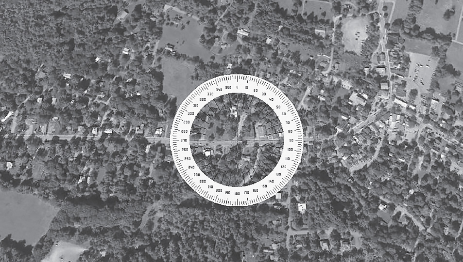
Fig. 14.5. A compass shows that Route 212 runs true east-west and thus aligns with the vernal and autumnal equinox sunrise and sunset.

Fig. 14.6. Route 212 west from town aligns with the vernal equinox sunset on March 21, 2014, at 7:03 p.m.
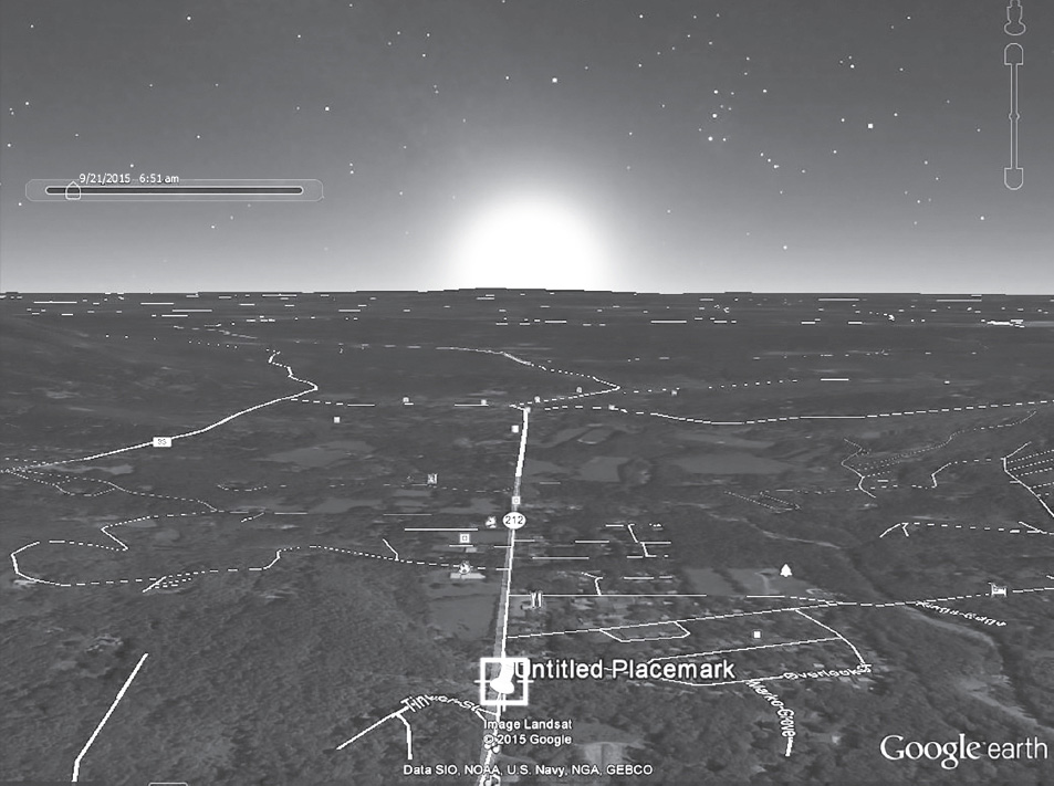
Fig. 14.7. Route 212 east from Bearsville, New York, aligns with the autumnal equinox sunrise at 6:51 a.m. on September 21.

Fig. 14.8. Rock City Road from Woodstock’s town center runs true north.