Geology is the study of Earth, its substances, makeup, forms, processes, and history. Geology is a great unifying discipline, built on the sciences of physics, chemistry, and biology, and using everything from astronomy and climatology to mathematics. Through geology, we come to understand the life cycle of our planet and thus explore the processes that bring about other bodies in our solar system and universe.
The field breaks down into two significant areas: historical geology, which delves into the formation and physical evolution of Earth; and physical geology, which describes the state of the planet and its physical structures and systems.
Historical geology begins before Earth itself was whole, when the processes that formed the materials of today’s Earth had just begun. It introduces us to the geologic time scale, the system by which scientists measure and classify the “ages of Earth.” Through this study, we can begin to glimpse the enormousness of the time scale that underlies the science of geology. We see how what we call “prehistory” in fact dwarfs the almost infinitesimally short span of human existence on Earth, only a part of which we call “history.”
Physical geology studies the formation of the largest structures on earth—from the highest mountain ranges to the deepest trenches on the ocean bottom—as well as smaller-scale objects such as rocks, minerals, and crystals.
Speculation about the origin and composition of Earth is as old as civilization itself. Most religions contain some form of creation myth, and many hold that the natural forces governing the planet are embodied by gods and spirits. In antiquity, various philosophers propounded theories of the natural world. Anaximander (610–ca. 546 B.C.) recognized that Earth is curved, but thought it cylindrical. Pythagoras (ca. 569–ca. 480 B.C.) correctly noted that Earth is a sphere. Xenophanes (ca. 570–480 B.C.), noting seashells on mountaintops, was among the first to recognize that Earth’s surface rises and falls over time. Aristotle (384–322 B.C.) offered plausible, but incorrect, theories for volcanoes, earthquakes, fossils, and other natural phenomena. Theophrastus (372–287 B.C.) classified a number of rocks and minerals, and Pytheas (fl.300 B.C.) described the tides and noted that they are controlled by the moon. Eratosthenes (ca. 276–ca. 194 B.C.) calculated the size of Earth with reasonable precision. In China, Zhang Heng (A.D. 78–139) developed a primitive seismograph.
Before the Enlightenment of the 18th-century, most European scientists were heavily influenced by religious belief, including the biblical story of creation. Scholars attempted to fix the age of Earth through a careful and literal reading of the Bible, concluding that creation took place about 6,000 years ago (far short of the present-day estimate of 4.6 billion years). Another biblical story with geologic import concerned Noah’s great flood, which was used by many scientists at that time to explain a number of observable geologic phenomena, such as the existence of marine fossils on mountaintops. Believing that great singular events such as the flood—either natural or divine in origin—were responsible for the formation of Earth, this school of thought came to be known later as catastrophism.
In the 17th century a few scientists developed ideas that we still believe to be correct today. The French philosopher René Descartes (1596–1650) was among the first to suggest that Earth is much older than biblical chronologies indicate. The Danish scientist Nicolas Steno (1638–86) correctly explained fossils as the remains of long-dead organisms and introduced the idea that layers of rock, called strata by geologists, were deposited at different times, with older layers lying below more recent ones (1669).
In the 18th century, the French polymath Georges-Louis Leclerc, comte de Buffon (1707–88), proposed (1778) that instead of the Judeo-Christian period of six days, creation took six epochs; and Earth might be about
75,000 years old instead of 6,000 years old—privately he thought it was even older. In Scotland in 1785, an amateur geologist, James Hutton (1726–97), suggested that Earth’s strata must have formed gradually. He claimed that cataclysmic events had not contributed in any significant way to the overall structure of the planet—a principle that we now call uniformitarianism. Simply stated, Earth’s history is a long, gradual development that can be explained in terms of natural forces that are still observable today. This idea became a cornerstone of modern geology.
Hutton had little influence initially, but another Scot, Sir Charles Lyell (1797–1875), expanded on and popularized Hutton’s ideas and work. He argued strongly that one could explain geologic history perfectly well by pointing to the geological processes—the action of wind and water, earthquakes, and volcanoes—presently at work and observable on Earth. Lyell rejected the short time line derived from the Bible and proposed a much greater period for the development and evolution of Earth. Lyell’s notion of a vastly great “geologic time” had a profound effect on science well beyond the study of geology and on our very understanding of its place in the world. The length of geologic time made possible the evolutionary theory of Lyell’s good friend Charles Darwin. It provided the time scale necessary for natural selection to take place.
Formation of Earth
Although Hutton described Earth as having “no vestige of a beginning,” that purely uniformitarian view was not accepted by most geologists. As with many ideas in earth science, one of the first to propose a scientific explanation of Earth’s beginnings was Comte Buffon, who suggested in 1745 that Earth was created from material splashed from the sun when a comet struck it. Buffon’s theory, however, assumed an impossibly large comet. In 1755 the German philosopher Immanuel Kant (1724–1804) proposed an idea that, with many adjustments by astronomers, became the basis of the modern theory of Earth’s formation. He said that Earth and the other planets coalesced from a dust cloud around the sun.
The modern version of Kant’s theory is as follows: About 4.6 billion years ago, a mass of gas and dust slowly condensed under the force of gravity into a spinning disk. This solar nebula continued to coalesce, with the sun forming at the center of the disk, and planets coming together out of the material in the outer regions. Earth and the other planets assembled as a result of countless collisions of smaller bodies, some mere microscopic specks and others as large as minor planets. The growing planet swept up and incorporated most of the debris in its path as it orbited the sun, and generated an extremely high temperature from the energy of all those impacts and explosions.
This violent infancy of bombardment and collision brought most of Earth’s minerals (some continue to arrive as dust or impacts from space), while the high temperature melted the entire planet. During this period, gravity drew heavier elements into the interior of the new planet, whereas lighter ones remained near the surface. As the planet cooled, Earth took on a three-part form: a thin crust, the surface of Earth; a solid mantle that makes up the main part of the planet; and a liquid core of molten metal (high pressure also created a solid inner core within the molten outer core).
Composition of the Earth
In their study of the Earth, scientists distinguish a number of distinct layers from the inner core—the center of which is about 6,400 km (roughly 4,000 miles) below the surface—to the farthest limit of the atmosphere, about 1,000 km (600 miles) above the surface. This section describes these layers, from the innermost to the outermost.
Core The core consists of two parts—one solid, the other liquid—both thought to be a mixture of iron and a lighter element, probably sulfur or oxygen. The solid inner core begins about 4,650 km (2,890 miles) from the surface, and the liquid outer core at about 2,900 km (1,800 miles) from the surface.
Mantle The bulk of the Earth—roughly two-thirds of its mass—is composed of the mantle, which extends from the outer core to within about 90 km (55 miles) of the Earth’s surface below the higher mountains, and to within only 5 to 8 km (3 to 5 miles) of the Earth’s surface below some areas of the oceans. Silicon dioxide constitutes almost half of the mantle, and there is an abundance of magnesium oxide, some iron oxide, and smaller amounts
of oxides of other metals. (Although silicon dioxide is known as quartz when found in the Earth’s crust, under the heat and pressure of the mantle it may have very different properties from the form we know.) Part of the upper mantle is somewhat fluid and is known as the asthenosphere.
Lithosphere Formerly called the crust, the lithosphere is the outermost solid layer of the Earth. Under the continents, the crust varies from 30 to 90 km (19 to 55 miles) in thickness, while under the oceans it is generally only 5 to 8 km (3 to 5 miles) thick. Continental and oceanic crust differ from each other in thickness and composition. Continental crust consists of granite and other relatively light rocks; oceanic crust is made up chiefly of basalt. The crust is separated from the mantle by the Mohorovi i
i discontinuity, or Moho.
i discontinuity, or Moho.Hydrosphere Water exists on Earth in all three states—solid, liquid, and vapor—and is found on the surface, within the crust, and in the atmosphere. The overwhelming majority of Earth’s water, over 97 percent, is contained in the oceans. Another 2 percent is the vast fields of polar ice and the glaciers and ice caps that exist in mountains and other high-altitude regions. The remaining portion is found in surface water—rivers, lakes, streams, etc.—and groundwater and soil water. The abundant presence of water is, of course, what distinguishes Earth from the other planets in the solar system. The unique conditions that allow so much water to exist in liquid form on Earth are the same conditions that make life possible.
Water—virtually all of it seawater—covers about 71 percent of the Earth’s surface and thereby constitutes a distinct layer of the Earth. Seawater varies in composition from place to place, but on average it is about 3.5 percent salts—that is, evaporating 100 pounds of seawater would yield 3.5 pounds of salt. Sodium chloride (ordinary table salt) constitutes 2.7 percent of seawater, or 77.8 percent of total solids in seawater.
Atmosphere The atmosphere is the gaseous layer that envelopes the Earth. The lower atmosphere consists of the troposphere and the stratosphere. The troposphere has an average thickness of about 11 km (7 miles), although it is only 8 km (5 miles) at the poles and as much as 16 km (10 miles) around the equator. Most clouds and weather phenomena occur in this region. The composition of dry air at sea level is: nitrogen, 78.08 percent; oxygen, 20.05 percent; argon, 0.93 percent; and carbon dioxide, 0.03 percent. There are also lesser amounts of neon, helium, krypton, and xenon. These proportions change with altitude, lighter gases being more common at higher altitudes, but they are approximately the same everywhere on Earth at the same altitude. There are also variable quantities of water vapor, dust particles, and other compounds whose proportions change from place to place at the same altitude—fewer dust particles being found over oceans, and less water vapor over deserts. Temperature decreases with altitude in the troposphere.
The stratosphere is found between 11 km and 50 km (7–30 miles) out from the Earth’s surface. Temperatures in this region rise slightly as altitude increases, to a maximum of about 0°C (32°F). Virtually coextensive with the stratosphere is the ozonosphere, or ozone layer, the region in which most of the atmosphere’s ozone is found. Because ozone absorbs most of the sun’s ultraviolet radiation, it is vital to the continued existence of life on the planet.
Beyond the stratosphere is the upper atmosphere, or ionosphere, so called because it is the layer in which atmospheric gases have been ionized by solar radiation. The ionosphere reflects certain wavelengths back to the surface, making it possible to transmit radio waves around the curve of the Earth. The ionosphere is further divided into the mesosphere, between 50 km and 80 km (30–50 miles), in which the temperature decreases with altitude to -90°C (–130°F); and the thermosphere, from about 80 km to 450 km (50–280 miles), in which the molecular temperature increases to as much as 1,475°C (2,690°F). To spacecraft traveling in the atmosphere, as the space shuttle does, however, the temperature seems cold because the molecules are so widely spaced. Beyond the thermosphere is the exosphere, extending to about 1,000 km (600 miles). In this layer, temperature no longer has the customary meaning.
Geologic Time
The life of our planet is measured in immense blocks of time divided into eons, eras, period, and epochs. These mark the development of Earth and form the geologic time scale. The planet’s origin is generally put at about 4.6 billion years ago, the age of the oldest meteorites found. To appreciate the true length of geologic time, we can think of those 4.6 billion years as represented by a single year. The oldest fossil records go back only about 40 days, and humans’ presence on the planet only about two hours. Modern humans would exist for only about five minutes of that year. As Lyell and Darwin demonstrated,
the vastness of geologic time makes the notion of evolution possible and comprehensible.
One of the major divisions in the history of life occurs at the beginning of the Paleozoic Era and the Cambrian Period, about 540 million years ago, when some of the main groups of invertebrats appear for the first time in the geologic record. As a result, geologists often speak of the period before this as Precambrian time (4.6 billion years ago to 542 million years ago, also known sometimes as the Precambrian Epoch). More than 88 percent of Earth’s history is Precambrian. Of the remaining time, when Earth has been home to animal life as we know it, the part that includes humans and their ancestors is less than 1 percent.
During the Mesozoic Era (245 million to 65 million years ago) marine reptiles, frogs, crocodiles and turtles appeared during the Triassic Period, and dinosaurs and early birds in the Jurassic and Cretaceous periods (208 million to 65 million years ago.) The Cenozoic Era, beginning 65 million years ago is divided into two periods, the Tertiary (65 million years ago to 1.8 million years ago) and the Quaternary (1.8 million years ago to the present); these are further divided into several Epochs that include the development of many of the mammals including horses, whales, elephants, dogs, and cats. (The Paleocene, Eocene, and Oligocene Epochs ended 23 million years ago.) During the next three Epochs lasting until 11,000 years ago (Miocene, Pliocene, and Pleistocene) giraffes, bears, mammoths, apes, and early hominids appeared; during the Pleistocene early human species, including Homo erectus, appeared. The final Epoch is the Holocene, which covers the last 11,000 years when modern humans, as well as much of the flora and fauna we know today, came into existence.
In recent years geologists have begun to say that the Earth may have entered a new Epoch at the beginning of the 20th century when science and technology combined to cause extraordinary changes in the composition of the Earth and its atmosphere. Some are now calling it the Anthropocene, the period when humans (anthro is Greek for man) changed the Earth through their use of fossil fuels, artificial nitrogen fertilizer, and the breeding of enormous numbers of livestock. Moreover, soaring population growth rates have introduced an element into the equation never experienced before.
Plate Tectonics
This scientific theory describes the drifting and shifting of large parts of Earth’s crust and upper mantle, called plates. These complex motions cause the formation of mountains and abysses, of volcanoes and earthquakes, and of the very location of Earth’s landmasses today. The plates move at an extremely slow pace—perhaps only a few centimeters each year, and the great distances now between them further deepen our appreciation of the length of geologic time.
In 1915 the German meteorologist Alfred Wegener (1880–1930) became the first to make a convincing case for these motions, although a few earlier scientists had recognized some parts of the concept. Wegener began with two simple observations: first, that the coastlines of some continents, such as Africa and South America, appear to fit together like the pieces of a jigsaw puzzle; and second, that many land species (contemporary ones and also those found in the fossil record) of widely disparate continents bear striking resemblances to one another. Wegener postulated that the continents must have at one time been joined together. Most earlier geologists and paleontologists had explained the similarities of coastline shapes as coincidence and the similar species as the result of “land bridges” which had once existed across oceans, but which had subsequently sunk into the sea floor.
Continental Drift Wegener gradually refined his theories and described a single, great protocontinent, which he dubbed Pangaea after the Greek for “whole Earth.” This massive body was surrounded by a single vast ocean, Panthalassa, or “universal sea.” For reasons that he was not at that time able to determine, Pangaea broke apart and pieces drifted slowly into place around the globe. This theory is known as continental drift. As refined by Wegener and later geologists, the theory states that toward the end of the Carboniferous period, Pangaea broke into two main bodies. The northernmost one, encompassing modern Europe, North America, and Asia, is called Laurasia. The southern one, Gondwana-land, contained Africa, South America, the Indian subcontinent, Australia, and Antarctica.
At the time of Wegener’s death, however, many remained unconvinced. After World War II the idea of continental drift gained wide acceptance, first in a modified form called seafloor spreading and later as a part of plate tectonics.
Seafloor Spreading One of the unexplained parts of continental drift concerned the great mountain chains and deep trenches found at the bottom of the oceans. The first to be recognized was the mid-atlantic ridge, which matches in general shape both the coastlines on each side of the Atlantic Ocean. A trench runs through the crest of this ridge. Other oceans have similar features, which are connected to form a worldwide mid-Oceanic ridge and also deep, curved trenches near chains of islands, such as the Marianas trench and the Philippine trench in the Pacific. In 1962, the American oceanographer Harry Hammond Hess (1906–69) proposed that the ocean floor is created at the mid-Oceanic ridge and then spreads, widening the oceans. Sometimes the spreading pushes continents farther apart, but in places the ocean floor away from the ridges plunges into deep trenches. In the early 1960’s the record of changes over long periods of time in Earth’s magnetic field, found preserved in the rock of the ocean floor and in rocks on continents, confirmed both seafloor spreading and relative changes in the positions of the continents. The best explanation was that Earth’s crust is broken into giant plates that move with respect to one another, sometimes carrying continents along.
Convergence and Divergence The action and interaction of the plates, both gradually and in occasional sudden outbursts, have created most of the familiar features of the landscape. When the leading edge of one plate meets another plate, we call it convergence, and this is largely responsible for the creation of most mountain ranges. When plates pull apart, a process called divergence, hot molten rock wells up into the void between them. This happens generally under the oceans and is how new material is commonly brought from Earth’s interior to the crust or surface. Sometimes, the plates neither come together nor pull apart, but simply move past each other, rubbing together along the edges. These transforms, as they are called, constitute the great geologic faults that we tend to fear, like the San Andreas Fault. The sudden spasms of activity lead to earthquakes, volcanic eruptions, and other natural cataclysms.
The lithosphere is composed overwhelmingly of rock, or fragments of rock. (The specific scientific study of rocks is called petrology.) Most rock occurs in deposits called beds, which can form in a vertical plane as well as the more common horizontal plane. Rocks, in turn, are made up of minerals, although for the most part, minerals are not rocks. A mineral is a naturally occurring element or compound that has a precise chemical formula. Geologists classify rocks in three main groups, sorted by the process of formation: igneous, sedimentary, and metamorphic.
Igneous rocks are rocks that have formed by solidifying or crystallizing from a molten state, either lava (molten rock on Earth’s surface) or magma (molten rock below the surface). Igneous rocks that form from lava are generally called volcanic rocks. Igneous rocks are often subcategorized according to texture, and in addition to the fine-grained rocks such as basalt, lava can also form glassy rocks, typified by obsidian. The speed of cooling normally determines the texture of the rocks, with glasses formed by very quick cooling. Since magma cools more slowly at depth than it does on the surface, rocks that crystallize far deeper within Earth, called plutonic rocks, typically form larger mineral crystals than the fine-grained surface-cooled rocks.
Sedimentary rocks are created by accumulation of deposited materials, including particles and fragments of rocks (sand or gravel), shells of sea animals, and chemical precipitates such as salt from evaporating water. The deposits slowly cement together over long periods of time. Examples of sedimentary rocks include sandstone, shale, and limestone. Sedimentary rocks often capture and contain fossils, footprints, and other clues to evolution.
Metamorphic rocks form as the result of heat, pressure, and chemical activity on igneous or sedimentary rock. These processes are slow and complex, highlighted by the recrystallization of the minerals of the rock. Without melting, the chemical elements and compounds reorganize under the influence of intense heat and pressure. Sometimes, even new minerals can be formed. As a result, metamorphic rocks are largely characterized by a regular crystalline structure, as opposed to the more random internal structure of igneous or sedimentary rocks. The regular patterned structure is typical of rocks like mica or gneiss, which tend to shear off cleanly (a property called
cleavage) when broken. These rocks typically form under the more extreme conditions of metamorphism, and their minerals are arranged in roughly parallel lines (foliation), giving the rocks something of a banded appearance.
U.S. 100% Reliance on Imports1 for Selected Strategic and Non-Strategic Minerals, 2010
| Mineral | Major Import Sources in Order of Importance (2006–2009) |
|---|---|
| Arsenic (trioxide) | Morocco, China, Belgium |
| Asbestos | Canada |
| Bauxite and Alumina | Jamaica, Brazil, Guinea, Australia |
| Cesium | Canada |
| Fluorspar | Mexico, China, South Africa, Mongolia |
| Graphite (natural) | China, Mexico, Canada, Brazil |
| Indium | China, Canada, Japan, Belgium |
| Manganese | South Africa, Gabon, China, Australia |
| Mica, sheet (natural) | China, Brazil, Belgium, India |
| Niobium (Columbium) | Brazil, Canada, Germany, Estonia |
| Quartz Crystal (industrial) | China, Japan, Russia |
| Rare Earths | China, France, Japan, Austria |
| Rubidium | Canada |
| Strontium | Mexico, Germany |
| Tantalum | Australia, China, Kazakhstan, Germany |
| Thallium | Russia, Germany, Netherlands |
| Thorium | United Kingdom, France, India, Canada |
| Yttrium | China, Japan, France |
| Note: 1. Import reliance is defined on a net basis: U.S. imports minus U.S. exports, adjusted for government and industry stock changes. Source: United States Geological Survey, Mineral Commodity Summaries 2011. | |
Strategic Minerals
Minerals are naturally occurring substances with characteristic and uniform chemical compositions and physical properties. A few minerals are elements (e.g. gold, iron, silver) but most are chemical compounds. Minerals are generally obtained by mining on land, although there is some ocean mining. Minerals are conveniently divided into two types: fuel and non-fuel minerals. This section deals with non-fuel minerals, especially those that are considered strategic. Strategic minerals are those deemed essential to the functioning of an economy, particularly with respect to war or other emergency conditions. Only some non-fuel minerals are strategic; others are widely found and produced. Some common and widely used minerals are so heavy and bulky that production tends to be relatively local; these minerals include crushed stone and sand and gravel for construction. Other minerals are traded internationally; the United States is wholly dependent on imports from other countries for at least 18 non-fuel minerals, both strategic and non-strategic.
In the United States, the concept of strategic minerals dates as far back as the First World War. By the late 1930s there were seven designated strategic minerals: chromium, manganese, mercury, mica, nickel, tin and tungsten. In the pre-computer, pre-space age economy of World War II, it was a relatively simple matter to identify a small number of strategic minerals. Now, although opinions differ, some 20 or more minerals can be considered as potentially strategic, depending on the nature of threat assessments. A strategic mineral is one that has key applications in defense or the civilian economy, cannot be easily replaced by other substances, and for which there are few or no available domestic supplies. Often strategic minerals have applications in the aerospace and electronics industries, alloys and superalloys, armaments, and high technology uses such as lasers and computers. An example of a strategic mineral is niobium (also called columbium), on which the United States is 100 percent import dependent. Niobium is vital as an alloy in steels and superalloys for aircraft turbine engines and other products; the principal source of imports is Brazil. The U.S. is also 100 percent import dependent for manganese, which is essential to iron and steel production; no practical technologiesexist for replacing manganese with other materials and there is little prospect of substantial domestic production. The main import sources are South Africa and Gabon. Chromium, used in stainless steel and non-ferrous alloys, has been a strategic concern since World War I; there are few domestic sources and the U.S. is currently 56 percent dependent on imports, but recycling accounts for 46 percent of demand. Other critical minerals have special properties. For example, tungsten (68 percent import dependent), which is used to make heavy metal alloys for armaments, has the highest known melting point of all metals, 6170o F (3410o C). The United States is more than 75 percent import dependent on nine strategic minerals.
9 Strategic Minerals with 75% or More U.S. Import Reliance1, 2010
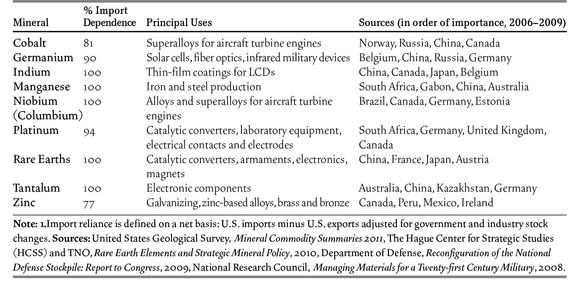
Policy toward strategic minerals requires the development of stockpiles, secure sources, recycling of materials, and research on substitute materials. The United States has had a strategic minerals stockpile program since just after World War II. The Defense National Stockpile Center oversees 20 depots, where 42 minerals are stored with a market value of $1.3 billion dollars. (Minerals research and reporting are functions of the U.S. Geological Survey.) Minerals are bought, sold and warehoused; there are sales from the stockpile when materials are no longer required and market disruptions can be minimized. Holding levels vary by mineral, year, and need.
The geopolitical problem of strategic minerals is assuring supplies and lines of communication. Source countries may be friendly or unfriendly, close or distant, developed or undeveloped, diverse or concentrated. Thus in times of international tension attempts may be made to diversify supplies and to draw supplies from friendly countries. The most favorable sources from the U.S. standpoint are countries such as Canada (cobalt, columbium, indium, thallium and other minerals) and Mexico (zinc, strontium and other minerals). These are friendly countries that are geographically close and linked to the U.S. by trade agreements. An example of a strategic mineral with favorable and diverse sources is zinc, which the U.S. imports primarily from Canada, Peru, Mexico and Ireland.
However, mineral supplies are not always conveniently and securely located in friendly countries, and are not always controlled by governments that meet reasonable standards of democratic process. Such cases can pose difficult and controversial geopolitical choices. For example, South Africa is the principal U.S. source of manganese, and dealing with this regime in the days of apartheid (dismantled beginning in 1989) provoked moral and ethical debate in the U.S. Chromium is a mineral imported by the U.S. from countries that have not always been friendly with the U.S.: South Africa, Kazakhstan, Russia, and China; in addition, shipping routes from all of these sources are subject to interruption in times of conflict.
There are also important moral and geopolitical issues in
trade of some non-strategic minerals. A leading example is “conflict diamonds,” diamonds mined in Africa, the proceeds from which have been used to support civil conflicts in Sierra Leone, Angola and elsewhere. The United Nations General Assembly condemned trade in these diamonds in 2000, and in an effort to halt trade in conflict diamonds, initiated the Kimberly Process, which attempts to provide a paper trial identifying diamonds that are not from conflict areas. The U.S., which imports about half (by value) of finished diamonds, has a critical role to play if this trade is to controlled. The problem of conflict diamonds is reminiscent of earlier bloody episodes in Africa in which indigenous and outside forces fought at least partly over minerals in the Congo, South Africa and elsewhere.
The international situation has changed in recent decades in ways that may reduce some concerns with strategic minerals. The collapse of the Soviet Union and the development of trading relationships with China have provided somewhat more secure sources of minerals, although China’s near-monopoly on rare earths and its attempts to control trade in them have been a concern (see “Lanthanides” in “Chemistry”). Russia, the former Cold War antagonist, supplies the U.S. with chromium, quartz crystal, cobalt and other minerals, and China supplies fluorspar, manganese, rare earths, tantalum and other minerals. As a result of such international developments, sales of some critical minerals from the U.S. stockpile have been permitted. However, geopolitical conditions can change rapidly and there will be a continued need for a strategic minerals policy.
Two other favorable developments are progress in materials science and in recycling. For example, the use of natural quartz crystals (except as gemstones) has largely been replaced by cultured quartz crystals, which are produced in highly controlled laboratory conditions. Among the many minerals for which recycling is an important source is chromium, which can be obtained from recycled stainless steel. These factors, like the easing of international tensions, provide more flexibility for the United States and other developed countries in strategic materials policy.
Photographs of Earth from airplanes and satellites, as well as those taken from the surface of the moon or from cameras in space, display the great landmasses and the connected world ocean. There are mountains and canyons, fertile plains and swamplands, vast barren deserts and wide inland lakes. Although hidden from sight, similar variety exists at the bottom of the ocean. The processes that gave rise to each of these features are common, yet each locality, each type, has its own unique geologic history.
Folds, Faults, and Joints
Earth’s surface is often deformed by tremendous pressures and forces. The resulting structures make up a major area of study for structural geologists. Faults and folds, which exist at the meeting point between various geologic planes and beds, hold special interest, as they are often the site of ongoing seismic activity.
Folds are deformed arrangements of stratified rock. Specialized terms for measuring and describing them include strike, the compass direction of the line made by the leading edge of an inclined bed; and dip, the angle of inclination of the bed from an imaginary horizontal plane. Where the limbs, or two sides of a fold, angle down, away from each other and from the central axis, the fold is called an anticline. Where they fold up, toward each other, it is called a syncline. The Appalachian Mountains in the eastern United States are characterized by complex fold structures.
Joints are long cracks or fractures common to most rock beds on the surface of Earth. Some joints result from folding or other deforming processes. Others are caused by contraction during the cooling of igneous rock, or when moist earth dries. Some are vertical, while others are parallel to the topographic surface of the area. The origin of these horizontal joints is uncertain, although possibly they are produced when rocks that have formed under great pressure at depth find their way to the surface through natural uplift, where they release some of that pressure.
Faults, like joints, are also breaks in Earth’s crust. The critical difference is that a joint is a stable separation, but in a fault there either is or has been movement of rock on one side of the break in relation to the other. Faults are classified according to the type of movement they exhibit—vertical, horizontal, or sideways.
The San Andreas Fault is a well-known example of a fault. This fault, which is actually a system of smaller faults, extends from the Gulf of Mexico to northern California, a distance of roughly 600 miles, and continues into the Pacific. The fault line represents the meeting point of two large-scale sections of the lithosphere, the Pacific and the North American plates. Most earthquakes tend to happen along fault lines, and the San Andreas Fault is very active and has been the site of some significant events, such as the great earthquakes of 1906 and 1989 in San Francisco.
Other common geologic structures are formed by the fluctuation of forces beneath the surface of Earth, acting on a crust where the material varies in density and flexibility. We see a variety of upwellings and depressions—called, variously, domes, plateaus, basins, and esplanades —that formed through these geologic processes combined with erosion by wind and water.
Mountains
Mountains occur largely in long chains called ranges and in closely located groups called clusters. Occasionally one mountain appears to be isolated from all the others. The principles of plate tectonics provided geologists with the first reasonable explanations for the sources of mountains. Mountains are formed by a variety of complex processes, and each mountain range or cluster has a unique origin.
Volcanic Mountains Some of the least complex mountains are volcanic; these form out of accumulation of material—magma, lava, ash, and other debris—that is released from the interior of Earth during a cataclysmic fissure or other event. Some of the iconic mountains of the world—Fuji, Kilimanjaro, Etna, Rainier—are volcanic mountains. Although volcanic mountains can appear in clusters, as they do in the Pacific Northwest of America, they do not arise in great chains and ridges like other forms of mountains. Where mountains appear in clusters or along ranges, they are formed from magma created by one plate sliding under another (along the west coasts of the Americas) or by a plate moving over a rising plume of magma (a “hot spot”) from deep in Earth’s interior.
Folded Mountains The collisions of Earth’s plates of crust that give rise to some volcanoes are related to the activity that causes folded mountains. These occur when plates push against each other also. Most of the great ranges of our world, such as the Alps and Himalayas, are folded mountains. In each case, a long period in which sedimentary material is built up is followed by the vertical uplifting of the mountains that results from compression, thrusting, and faulting of lithospheric plates. Much of this accumulation occurs in subsidence areas (where the crust has lowered), such as geosynclines, which are long, troughlike depressions, sometimes underlying large bodies of water.
Block Mountains The origin of block mountains (sometimes called fault-block mountains) is also caused by collision of plates. Plates or sections of the crust collide and exert pressure against each other or pull apart, causing tension. When rock sections break, the results include large differences in elevation between the sections. Such processes are responsible for many of the rift valleys in Africa and for the Basin and Range region of the American West. The midocean ridges are also caused by plates moving apart from each other.
Last, mountains and ranges can be the result of a combination of processes that may include faulting, folding, and some igneous or volcanic element. Scientists describe these as complex mountains.
Glaciers
Glaciers are vast sheets of ice and rock that advance and recede across Earth’s surface. They are found throughout the world at very high elevations, as well as in the high-latitude regions approaching the poles. Although they are an uncommon feature of the current landscape, glaciers played a major role in the geology of the relatively recent past and are responsible for many of the landforms and formations we take for granted today.
In order to form, glaciers require not only consistently cold temperatures, but also a significant amount of snowfall. The snow provides the raw material that accumulates to maintain the mass of the glacier. In some regions, such as parts of Antarctica, there is no permanent snow or ice cover on the land, because even though the temperature is sufficiently low, the region is too dry.
Once snow settles on the ground, it tends to undergo a structural transformation and is recrystallized into granules of ice. It is this new ice that becomes part of a glacier. Glaciers are said to “flow” or to behave like “rivers of ice,” but this flow usually occurs very slowly.
Glacial advance is tremendously slow, ranging from a few inches to several miles annually, although it is punctuated by periods of greater velocity, called surges, which are possibly attributable to the breaking up of damlike accumulations of ice and rock at the leading edge of the ice sheet. The movement of ice sheets is partly due to the instability of the ice, which creates a certain plasticity. Some motion also results from the slippage of the entire ice sheet over the surface of the bed underneath it. As with rivers or streams, the central portion of a glacier tends to advance faster than the edges.
An ice age is a period of large-scale glaciation. Ice ages have occurred regularly throughout the history of the planet. The last one, which occupied the Pleistocene epoch and is believed to have ended as recently as 11,000 years ago, saw an enormous sheet of ice advance downward from the North Pole and spread across a major percentage of the Northern Hemisphere. In North America, the ice traveled down as far as New York in the East, Wisconsin in the Midwest, and Montana and Washington in the West. In Europe, it covered Scandinavia, northern Germany, Russia, and the British Isles. The Andes of South America, as well as major Asian mountain ranges, were also overtaken.
Many geologic features of today—including the sharply cut fjords of Scandinavia, the long lateral ridges of the northeastern United States, and large inland bodies of water such as the Great Lakes—are relics of the last ice age. The Pleistocene epoch probably had numerous periods of glaciation, with periods in between when the ice sheets shrank or receded. Scientists believe that we may be in just such an interglacial period and that in the not too distant future, another ice age is likely to be upon us.
The apparent solidity and constancy of the land mask continued activity and upheaval. Just as the atmosphere can produce catastrophic phenomena such as hurricanes and gales, the lithosphere is also the site of cataclysmic events, from terrible earthquakes and volcanic eruptions to more commonplace landslides and sinkholes.
There were about 1,500 active volcanoes on the Earth’s surface in 2009, with approximately 50 eruptions per year. The majority of these volcanoes are found in the “Ring of Fire,” an almost 25,000 mile-long, horseshoe shaped seismically active belt that outlines the length of the Pacific Rim. The ring is formed by the subductions and collisions of seismic plates. The major plates found within this region are the Juan de Fuca plate, Filipino plate, Pacific plate, Cocos plate, Nazca plate, and the Antarctic plate. About 75 percent of the world’s volcanoes are located here and 90 percent of the world’s earthquakes take place here.
Earthquakes
Tension and compression build up in the Earth’s crust, particularly along faults, where large masses of rock or tectonic plates push against each other. When the pressure is released, it usually happens quite suddenly, and the resulting vibrations, or seismic waves, are observed as an earthquake (the word seismic means “shaking” and simply refers to earthquakes). Several kinds of seismic waves are produced. Surface waves—also called L waves—travel along Earth’s surface. Body waves, which travel through the interior, can be either compressional waves (P waves) or shear waves (S waves), which displace material in different directions and at different speeds as they travel. P waves are back-and-forth waves, essentially the same as sound waves; but for S waves the movement of rock is perpendicular to the movement of the wave, similar to ocean waves.
There are thousands of tiny earthquakes annually. Most are gentle tremors detectable only by sensitive seismographs, but each year a few are of moderate or greater intensity. Major earthquakes are dangerous and destructive, causing buildings or rock formations to fall, often resulting in great loss of life. The point of origin of an earthquake’s energy is called its focus, and the depth of the focus below the surface of Earth is the focal depth. The point on the surface directly above a quake’s focus is the epicenter, and the location of an earthquake is defined by both the epicenter and the focal depth.
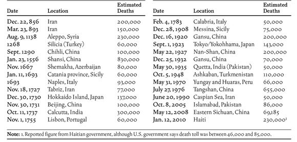
Major earthquakes have occurred frequently around the Pacific Rim and running through the Indian subcontinent to the Mediterranean region. Some places hit by disastrous earthquakes have been California, Alaska, Peru, El Salvador, Iran, Turkey, the islands of the southern Pacific, China, and especially Japan.
Due to its location on the meeting point of the Eurasian, Filipino, and North American plates, located along the “Ring of Fire,” Japan has had over 40 major earthquakes in its recorded history. The 1730 Hokkaido Island quake killed 137,000 people while the 1923 Great Kanto earthquake killed upwards of 142,000, making it the deadliest in Japan’s history. Up to 1,500 earthquakes are recorded in Japan yearly, although they vary greatly in magnitude. Earthquakes in Japan are usually accompanied by tsunamis—such as the deadly Mar. 11, 2011 Tohoku earthquake that left over 15,000 people dead, with nearly 8,000 more people missing or unaccounted for. The tsunami that followed totally destroyed towns and villages and flooded a nuclear power plant that spewed radioactive material as far away as 20 miles.
In 2010, a powerful earthquake struck the island nation of Haiti, destroying the capital city of Port-au-Prince and killing more than 200,000 people, making it one of the most destructive quakes in history. However, the United States Agency for International Development puts the death toll between 46,000 and 92,000 people.
Measuring Earthquakes The size of an earthquake is generally reported in the United States using the Richter scale, a system developed by the seismologist Charles Richter (1900–85) in 1935. The Richter scale measures the magnitude of an earthquake, that is, the size of ground waves generated by an earthquake as shown on a measuring device called a seismograph. Each whole number on the scale represents a tenfold increase (or decrease) in magnitude: a magnitude 6 earthquake produces a ground wave 10 times greater than a magnitude 5.
This does not mean, however, that a magnitude 6 earthquake has 10 times the energy as one of magnitude 5. Measuring the actual energy requires instruments placed at the site of the earthquake. Various methods have been developed for inferring energy from magnitude, and these suggest that one change in magnitude corresponds to a thirty- to sixtyfold change in energy. According to these proportions, the energy of a magnitude 8 earthquake, a very serious event, can be 1 million to 10 million times as much as that of a magnitude 4 earthquake, one that can be felt but causes almost no damage.
Richter Scale and Effects Near the Epicenter
Note: The epicenter is the point on Earth’s surface above the center of the quake
Below 2.5 Not felt except by a very few.
2.5 to 3.5 Felt only by a few persons at rest, especially on upper floors of buildings.
3.5 to 4.5 At lower levels or farther from the quake, it is felt by many people, sometimes quite noticeably indoors, especially on upper floors of buildings. At somewhat higher levels or nearer to the epicenter, during the day the quake is felt indoors by many but outdoors by few. Sensation is like heavy truck striking building. At the highest level, the earth movement is felt by nearly everyone, with many awakened if the quake occurs during the night. Disturbances of trees, telephone poles, and other tall objects can sometimes be noticed.
4.5 to 6.0 Felt by all. Some heavy furniture moved; there will be a few instances of fallen plaster or damaged chimneys. Other slight local damage may occur. At higher level, however, everybody runs outdoors. At the upper level, while damage is still negligible in buildings of good design and construction, there can be moderate damage even to well-built ordinary structures; there will be considerable damage to poorly built or badly designed structures.
6.0 to 7.0 Destructive earthquake. Damage may be slight in specially designed structures, but will be considerable in ordinary buildings, often with partial collapse. Damage will be great in poorly built structures, including collapse of chimneys, factory stacks, columns, monuments, and walls. At the upper level, damage is likely to be considerable even in specially designed structures. Most ordinary buildings will be shifted off foundations. Even the ground will be cracked conspicuously.
7.0 to 8.0 Major earthquake. Worldwide, about 10 of these occur each year. Some well-built wooden structures will be destroyed. Most masonry and frame structures will be destroyed along with their foundations. Ground becomes badly cracked.
8.0 and above Great earthquakes. These occur once every five to 10 years. Few if any masonry structures remain standing. Bridges are destroyed. Broad fissures appear in ground. At the highest levels and near the epicenter, damage total. Waves seen on solid ground. Heavy objects thrown upward into air.
Major Earthquakes (50,000 deaths or more)
Tsunamis
A tsunami is a destructive wave, usually formed by an underwater earthquake, a coastal landslide or the eruption of a volcano. These events displace huge amounts of water, causing it to rush towards land with devastating results. At sea a tsunami travels up to 500 miles per hour and is mostly underwater, as a boat encountering one is likely to experience a rise in sea level of only a few feet. As the wave approaches shore the sea-bed becomes steeper and more shallow, causing the tsunami to push above the surface. Rapidly, coastal waters are sucked out to sea, only to return in a crushing wave of up to 100 feet above sea level. This rush of water undergoes several oscillations (towards land, then back to sea,) destroying virtually anything in its path.
Historians believe the first known tsunami to have taken place in 6100 B.C. in the Norwegian Sea, based on recovered sedimentary material. In the 5th century B.C., the historian Herodotus described the Persian siege of the Greek town of Potidaea and its subsequent destruction by “a great flood-tide, higher, as people of the place say, than any of the many that had been before.” And in 1755 an earthquake in Lisbon, Portugal caused a tsunami in Lisbon Bay, drowning many who had come to watch the suddenly receding tides. That earthquake and tsunami helped lead scientists to begin serious study of the Earth’s makeup.
To this date the most destructive tsunami was caused by the eruption of the volcano Krakatoa in Indonesia in 1883. Approximately 36,000 people were killed in the ensuing waves with whole islands and villages left submerged throughout the entire Pacific region. On December 26, 2004 a tsunami off the island of Sumatra, Indonesia killed over 200,000 people in a wide area of Asia including Sri Lanka and India. Seven hours later it caused damage at the Horn of Africa, up to 1,800 miles away. An early warning system, established by the United States after a 1946 tsunami hit Hilo, Hawaii, could have saved many lives. As a result U.N.E.S.C.O. has set a goal to establish similar warning systems for the Indian Ocean and eventually the entire world.
Japan has experienced at least twenty major tsunami events in the modern era, so not surprisingly the word tsunami (“harbor wave”) originated there. The March 11, 2011 event, caused by a 9.0 magnitude earthquake off the coast of Japan, left more than 23,000 people dead or missing and caused a nuclear crisis at the Fukushima I Nuclear Power Plant. The destruction was highlighted by the fact many around the world watched on live television, as video and photos poured in from Japan.
Times focus
Blindsided by Ferocity Unleashed by a Fault
On a map of Japan that shows seismic hazards, the area around the prefecture of Fukushima is colored in green, signifying a fairly low risk, and yellow, denoting a fairly high one. But since Japan sits on the collision of several tectonic plates, almost all of the country lies in an earthquake-risk zone. Most scientists expected the next whopper to strike the higher-risk areas southwest of Fukushima, which are marked in orange and red.
“Compared to the rest of Japan, it looks pretty safe,” said Christopher H. Scholz, a seismologist at the Lamont-Doherty Earth Observatory at Columbia University, referring to the area hit worst by the quake on March 11. “If you were going to site a nuclear reactor, you would base it on a map like this.”
Records kept for the past 300 years indicated that every few decades, part of the Japan trench, an offshore fault to the east of Fukushima, would break, generating an earthquake around magnitude 7.5, perhaps up to magnitude 8.0. While earthquakes that large would be devastating in many parts of the world, the Japanese have diligently prepared for them with stringent building codes and sea walls that are meant to hold back quake-generated tsunamis.
Shinji Toda, a professor of geology at Kyoto University in Japan, said a government committee recently concluded that there was a 99 percent chance of a magnitude-7.5 earthquake in the next 30 years, and warned there was a possibility for an even larger magnitude-8.0 quake. So much for planning. Although Japan’s foresight probably saved tens of thousands of lives, it could not prevent the vast destruction of a magnitude-9.0 temblor, which releases about 30 times as much energy as a magnitude-8.0 quake. It was the largest ever recorded in Japan, and tied for fourth largest in the world since 1900. Thirty-foot tsunamis washed over the sea walls and swept inland for miles. The death toll is expected to be more than 20,000, and nearly 500,000 were living in shelters.
“I was surprised,” Dr. Toda said. “Nobody expected magnitude 9.”
This was not the first time scientists have underestimated the ferocity of an earthquake fault. Many were also caught by surprise by the magnitude-9.1 quake in 2004 off Sumatra, which set off tsunamis radiating across the Indian Ocean, killing more than 200,000 people.
Sometimes, scientists are blindsided by earthquakes because they occur along undiscovered faults. The deadly earthquakes in New Zealand in 2011; in Haiti in 2010; in Northridge, Calif., in 1994; and in Santa Cruz, Calif., in 1989 all happened along faults that scientists were unaware of until the ground shook. That raises a worrisome question: How many major quakes are lurking in underestimated or unknown faults?
The basic dynamics of earthquakes have been understood for decades. Earth’s crust is broken into pieces—tectonic plates—which slide and collide. But the sliding is not always smooth. When the plates stick together, they begin to buckle. Stress builds until the ground breaks and jumps, releasing energy in the form of vibrations: an earthquake. Not surprisingly, places close to plate boundaries are beset by earthquakes, while those far from the boundaries are not earthquake-prone.
The largest earthquakes occur in subduction zones, places where an ocean plate collides with and slides under a continental plate, particularly around the edge of the Pacific Ocean.
But some subduction zones seemed to produce more large earthquakes than others. One explanation was offered in 1980, when Hiroo Kanamori of the California Institute of Technology and Larry J. Ruff, now at the University of Michigan, published a paper that said giant earthquakes occurred more often along ocean faults where the subducting ocean plates were geologically young. The younger plates, like those off Alaska and Chile, were warmer, less dense and harder to push down into the Earth’s mantle, their thinking went. Meanwhile, the older, colder and denser ocean plates like those off Java and the Marianas trench in the Pacific would sink more easily and not produce the giant catastrophic quakes.
And yet the Pacific plate off Japan is 130 million years old, one of the oldest, and it generated a magnitude-9.0 counterexample.
Most regions of the world have less historical data than Japan, making it even harder to judge the earthquake patterns. Haiti is a prime example.
Even the notion of an earthquake fault—a long crack in the earth—is not quite as certain as it once was. Near Landers, Calif., seismologists had identified three faults, each capable of a magnitude-6.5 quake. Then, in 1992, an earthquake shook along all three faults at once, at a magnitude of 7.3.
In Japan’s history, there does seem to have been a precedent for the recent quake, but it took place more than a thousand years ago. A text known as Nihon Sandai Jitsuroku, or The True History of Three Reigns of Japan, described an earthquake in July 869 and a tsunami that flooded the plains of northeast Japan: “The sea soon rushed into the villages and towns, overwhelming a few hundred miles of land along the coast. There was scarcely any time for escape, though there were boats and the high ground just before them. In this way about 1,000 people were killed.” These were the same plains that were submerged this month. Analysis of sediments left by the 869 tsunami led to an estimate that the earthquake had a magnitude of 8.3.
Volcanoes
A volcano is an opening, called a vent or fissure, in Earth’s crust through which solid rock fragments propelled by gases and lava (molten rock) escape from Earth’s interior. The term volcano is used to describe both the vent itself and the mountain of accumulated discharged materials that builds up around it. The solid material is usually called ash or cinders when the pieces are small, but larger rocks are called bombs. When large amounts of ash, bombs, lava, or gases escape destructively, the process is called an eruption of the volcano. Volcanic eruptions can be both beautiful and horrific. History has seen untold thousands of lives lost and entire pockets of civilization wiped out by volcanic eruptions. Names like Vesuvius, Tambora, Krakatoa, Pinatubo, and Mount St. Helens echo as reminders of Earth’s inherent instability and destructive power.
An active volcano either is currently erupting or has erupted in the very recent past (that is, in recorded history) and is considered likely to do so again, as Hawaii’s Kilauea is. A volcano is dormant (sleeping) if it is not currently erupting but is believed likely to erupt at some point in the future. Many of the volcanic mountains in the American Northwest are considered dormant. We say a volcano is extinct if it has not erupted in historical time, and if geologists believe it unlikely to erupt in the future, because of a lack of seismic activity or other indicators of subsurface volatility. Africa’s Mount Kilimanjaro is considered extinct.
Molten rock below Earth’s surface, or magma, tends to rise because liquid rock is less dense than the surrounding solid rock and because magma contains gas under pressure. It collects in pockets or reservoirs under the surface, where its heat causes more of the surrounding rock to melt. Pressure builds in these reservoirs, and the magma and gases eventually force their way up through the surface, either through existing vents or fissures or through structurally weak sections of the crust. Some eruptions seem slow, with lava seeping and flowing gently through cracks in the surface; others are more like massive detonations, spewing great plumes of ash, rock, and steam over large areas of land and into the atmosphere. Either way, volcanic eruptions invariably alter the landscape, sometimes by blasting away large peaks and structures and always by depositing quantities of new material in the form of lava and debris, which build up new land formations. The vent becomes enlarged into a hole in the Earth called a crater. Sometimes an exploded volcano forms a caldera, a large-scale crater created by the collapse of underground magma reservoirs below the volcano.
Eruptions are categorized using the names of historically notable volcanoes or volcanic regions. The quietest eruptions are called Hawaiian and involve gentle emanations of lava and the ejection of debris with some small explosions. Somewhat more dramatic are Strombolian eruptions (after Stromboli in the Mediterranean), with constant recurring explosions and a relatively mild discharge of heavy, viscous lava. Plinian eruptions (after the Roman naturalist Pliny the Elder, killed in an eruption of Vesuvius in A.D. 79 that was described in detail by his nephew, Pliny the Younger) are still more explosive. Immediately prior to these eruptions, the magmatic pressure builds up behind a plug that has naturally formed in
the vent that would have been the natural channel to the surface. Eventually, the dam bursts, ejecting material and vapor with great velocity. The most violent eruptions are the Peleean (named for a destructive eruption of Mount Pelée on Martinique in 1902), in which enormous clouds of fine ash and cinder, small bits of molten lava, and superheated steam are propelled sidewise from the eruption, destroying all in the path of the blast.
As catastrophic as volcanoes can be, they are also a mechanism by which valuable elements and minerals, including iron, magnesium, and potassium, are brought from Earth’s interior to the surface. Volcanic soils are tremendously rich in these materials and are therefore very fertile. In addition, the study of volcanoes, much like the study of earthquakes, has engendered a much deeper understanding of the mechanisms and processes at work in Earth’s interior.
Historic Volcanic Eruptions
Mt. Vesuvius, Italy (Aug. 24–26, 79) Despite being dormant for centuries, Mt. Vesuvius erupted, crushing the city of Herculaneum under a torrent of mud and burying the cities of Pompeii and Stabiae under 25 meters of ash. Best known for the destruction of Pompeii and its remarkably preserved ruins, rediscovered in 1748, that show how its citizens died almost instantly while going about their daily lives. An estimated 2,000 people were killed.
Mt. Tambora, Sumbawa, Indonesia (Apr. 5, 1815) The largest volcanic eruption in recorded history, the explosion could be heard over 1,200 miles away on the island of Sumatra. The following year, 1816, became known as the “Year Without a Summer” because of the ash cloud’s effect on the global climate. The resulting changes in weather patterns led to poor harvests while livestock died in large numbers. This led to one of the worst famines of the 19th century. Many of the estimated 92,000 victims died of starvation and disease, with up to 12,000 being killed by the actual eruption.
Krakatoa, Indonesia (Aug. 26, 1883) A series of four massive explosions destroyed practically the entire island and produced what is considered the loudest sound ever in modern history—heard nearly 3,000 miles away. Most of the 36,000 victims died in the ensuing tsunamis, as the island was sparsely populated. Global temperatures dropped by an average of 1.2 degrees Celsius following the eruption, with weather patterns remaining changed for up to five years afterwards.
Mt. Pelee, Martinique (May 8, 1902) Dubbed the worst volcanic disaster of the 20th century, 15 percent of the population, or 30,000 people, were killed in the eruption. Most of the victims were in the nearby town of St. Pierre, which was completely destroyed by the pyroclastic flow—a superheated cloud of ash, gas, and rock.
Mt. St. Helens, Washington, U.S. (May 18, 1980) Following a series of earthquakes that caused a huge bulge in the side of the mountain, the north face of Mt. St Helens collapsed, causing the largest known debris avalanche in recorded history. The pyroclastic flow flattened plants and buildings over a 230 square mile area, while 3,900,000 cubic yards of material was transported to the Columbia river, a distance of 17 miles. Due to its remote location, only 57 people were killed in the eruption.
Nevado del Ruiz, Colombia (Nov. 13, 1985) Despite being monitored by scientists, the sudden eruption occurred amidst a terrible storm, preventing authorities from evacuating the surrounding areas. The snow-covered glacier quickly melted, sending rivers of water, hot ash, and debris cascading down the mountain. Most of the 23,000 victims were killed in this debris flow, which was recorded at speeds up to 31 miles per hour and reached distances of 45 miles away.
Mt. Pinatubo, Luzon, Philippines (June 9, 1991) After two months of minor earthquakes and emissions, Mt. Pinatubo erupted, sending ten cubic meters of material into the atmosphere and making it approximately ten times larger than the eruption of Mt. St Helens. Over 800 people were killed in the eruption with the majority being crushed under buildings toppled by the weight of the huge amounts of ash. The eruption had an enormous effect on the economy of the Philippines, with the GDP falling more than 3 percent between 1990 and 1991.
Eyjafjallajokull, Iceland (Apr. 14, 2010) The series of eruptions sent massive plumes of ash into the atmosphere, caused electrical storms and disrupted flights to Europe over a period of six days. Caused minor damage to infrastructure resulting from melting ice and mud flows, but its greatest impact was on the airline industry and the economies of Europe.
Paleontology is the science of prehistoric life, generally defined as organisms that lived more than 10,000 years ago, prior to the end of the most recent ice age. The science is based on the nature and distribution of fossils, the remains or traces of organisms. In addition to satisfying our curiosity about organisms that lived long ago, paleontology provides evidence to support the concepts of evolution and continental drift (the idea that the positions of the continents have changed over time as a result of plate tectonics). It also helps to support the theory that impacts of asteroids and comets have been instrumental in wiping out significant portions of Earth’s life at intervals in our planet’s history—so-called mass extinctions. Economically, the study of fossils is valuable in searching for deposits of oil, coal, and other minerals, and in locating limestone and other materials used for construction and building.
The science has subdisciplines, such as paleobotany, the study of ancient plants; paleozoology, the study of ancient animals; and taphonomy, the study of the biological, chemical, and physical processes that lead to an organism’s fossilization or its disintegration. Paleontology also relates to other disciplines that study the Earth’s past, such as paleogeography, which focuses on Earth’s geography as it existed during past eras; paleoecology, which considers the relationships between fossil organisms and the environment in which they lived; and paleoclimatology, the study of ancient climates.
The History of Paleontology
Ancient peoples knew of fossils, and presented various explanations to account for them. Some cultures turned fossils into mythological creatures and described giants that once terrorized Earth. In Greece, Herodotus (ca. 484–ca. 425 B.C.) and others realized that fossil seashells found in mountains were the remains of once-living creatures; but Aristotle (ca. 384–ca. 322 B.C.) suggested that fossils were natural accidents, produced much as crystals are produced, a theory that held sway for many centuries.
The scientific study of fossils began in the 17th century. In 1667 Nicolaus Steno (1638–86) showed that fossils previously believed to be serpent tongues were shark teeth. He proposed that sediments are deposited in horizontal layers, or strata; that strata represent different ages; and that fossils are remains of living creatures from those ages. William Smith (1769–1839) showed that each rock layer has its own distinctive mix of fossils. In 1815, Smith published the first geologic map of England, proving the value of using fossils to define the order of rock layers.
Georges Cuvier (1769–1832), often called the founder of paleontology, discovered that species become extinct, identified pterosaurs as flying reptiles, and was the first scientist to systematically compare the anatomy of fossils and living organisms.
In South America during the 1830’s, Charles Darwin (1809–82) examined the fossil remains of giant sloths and other extinct animals, and found fossils of ocean life high in the Andes. His publication in 1859 of On the Origin of Species, which proposed that a process he called natural selection is the main force in evolution, profoundly influenced paleontologists. They began looking for ancestors of modern organisms as well as “missing links”—intermediate, transitional forms between known species. The first such link, discovered in Germany in 1861, was Archaeopteryx, a primitive bird with characteristics of both its flightless reptile ancestors and modern birds.
Radioactive dating, computer imaging, molecular genetics, and other technologies introduced in the 20th century greatly expanded the study of fossils. Today, new fossil finds are filling blanks in the biological record and pushing back the dawn of life.
Fossils
More than 1 million species of fossil organisms have been identified. These range from microscopic bacteria to giant dinosaurs and tree ferns. Evidence of truly ancient fossils, much of it controversial, suggests that Earth may have had simple bacteria-like life as long as 3.5 billion years ago.
Fossil Types There are two basic types of fossils. Body fossils are either actual remains of organisms or remains in which original chemicals have been replaced by other chemicals, typically silicon dioxide and other minerals from water seeping through the buried remains. Shells, bones, teeth, and petrified wood are common body fossils. Softer tissues, such as those that compose worms, are less likely to be preserved; they often are eaten by animals or broken down by bacteria and other decomposers. Thus the abundance of a species in the fossil record does not necessarily indicate its relative abundance during the age in which it lived.
Trace fossils are marks made by the activities of ancient organisms, such as footprints, burrows, leaf imprints,
chemical traces, and tooth marks on bones. They reveal much about anatomy as well as the habits and habitats of their creators. For example, footprint size and the distance between prints in a track provide clues to the size, weight, and speed of the animal that made the track. Pollen from plants preserved in bog sediments in northern Europe demonstrates that cold-adapted species once lived much closer to the equator than they do today.
Dating Fossils The age of a fossil may be determined using relative and absolute dating methods. Relative dating methods compare the ages of various fossils, indicating their relative ages but not their actual ages. For example, stratigraphy is based on the fact that in an undisturbed sequence of rock layers, fossils in lower layers are older than those in upper layers. Amino acid racemization uses the fact that amino acids—the building blocks of proteins—exist in two mirror-image forms, L and D. Amino acids in living things are of the L-form. At death, the L-form racemizes, or changes, into the D-form at a more or less steady rate, though this rate varies from site to site depending on environmental conditions. Thus the greater the extent of racemization, the older the fossil.
The discovery of radiation and radioactive decay led in the 20th century to the development of absolute dating methods that provide specific ages for fossils. These methods are based on the fact that radioactive isotopes decay at a specific rate, called a half-life. For instance, potassium 40 (half-life approximately 1.25 billion years) decays into argon 40 and calcium 40. Potassium-argon dating is usually used to date fossils found in volcanic rock or ash deposits, which are rich in potassium. Another technique, electron spin resonance dating, uses the changes that background radiation indirectly makes, at a predictable rate, in the magnetic field of crystalline minerals. It is used to date calcium carbonate in shells, teeth, and coral.
Dinosaurs The fossil organisms of greatest appeal to laypeople are dinosaurs, land-dwelling reptiles that evolved from reptiles called thecodonts about 225 million years ago. Scientists have named approximately 700 species of dinosaurs. The smallest was Compsognathus longipes, a chicken-sized dinosaur that lived about 145 million years ago. The heaviest included Brachiosaurus, which lived about 150 million years ago and weighed as much as 70 to 90 tons. The longest may have been Seismosaurus, a long-necked plant eater that lived about 150 million years ago and reached lengths of more than 130 feet (39 meters).
Dinosaurs are classified in two groups. Ornithischia, or bird-hipped dinosaurs, had pelvic bones arranged like those of a bird hip, with the pubic bone bent backward. They were plant eaters with hooflike claws. This group included the duck-billed hadrosaurs, plated stegosaurids, beaked ceratopsians, and long-snouted iguanodontids.
The second group is the Saurischia, or lizard-hipped dinosaurs. Their pelvic bones were arranged like those of a lizard hip, with the pubic bone pointing forward. There were two main subgroups. The Theropoda were fast, agile hunters; they included Tyrannosaurus rex, Velociraptor, Allosaurus, and the ancestors of modern birds. The Sauropodomorpha were plant eaters with massive bodies, long tails, and front legs smaller than the back legs. Brachiosaurus was a well-known example.
Dinosaurs became extinct around 65 million years ago during a mass extinction known as the Cretaceous-Tertiary or K/T event. It is believed that the event resulted from the collision of an asteroid with Earth, at a point on the northwest coastline of the Yucatán Peninsula in Mexico. A crater 106 miles (170 kilometers) across formed, shooting billions of tons of matter into the atmosphere, which blotted out the sun and caused global temperatures to plummet.