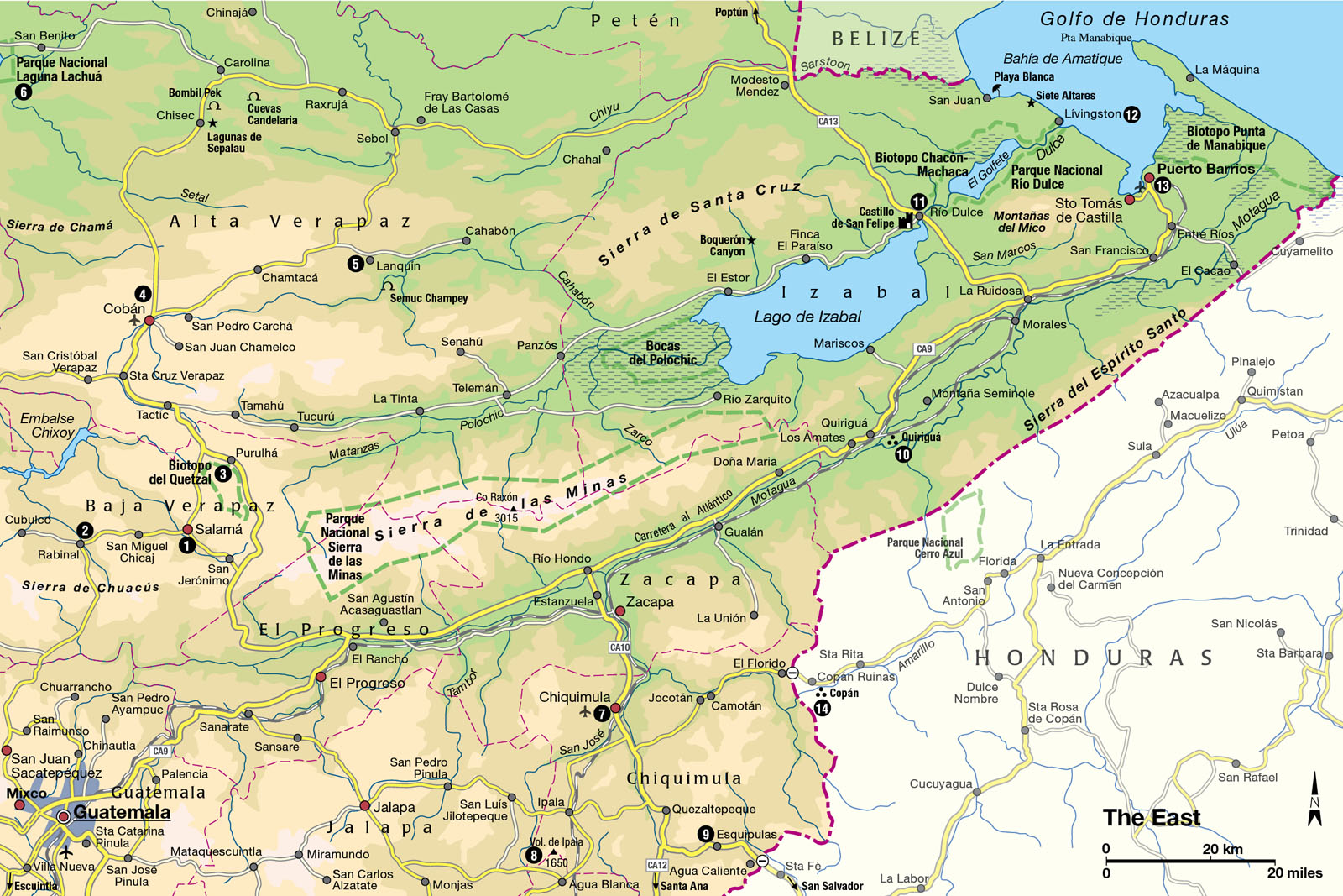
The East
This varied region has some superb lakes, the wonderful carved stelae of Quiriguá and Copán, a quetzal reserve, and a fascinating Caribbean coastal culture.
Main Attractions
Eastern Guatemala only attracts a slim slice of the country’s burgeoning tourist industry – it is a region that most visitors hurry through on their way to the ruins of Petén or Copán, just over the Honduran border. Yet there is plenty of interest here, most obviously the extreme juxtaposition of landscapes: desert, wetlands, both arid and humid mountain ranges, lowland jungle, tropical coastline, and even (this being Guatemala) a volcano or two. Creditably, a network of protected reserves has been established to safeguard these remarkable ecosystems, and the unique habitat of species like the manatee and the quetzal, the national bird – but this reserve status is all too often poorly enforced.
This chapter covers a vast swathe of land, which is divided into three distinct regions: the twin departments of Alta and Baja Verapaz, to the northeast of Guatemala City; the huge department of Izabal, which encompasses the Caribbean coast and Lago de Izabal; and finally the dry mountainous departments of Chiquimula, Zacapa, El Progreso, and Jalapa, known locally as “El Oriente.”
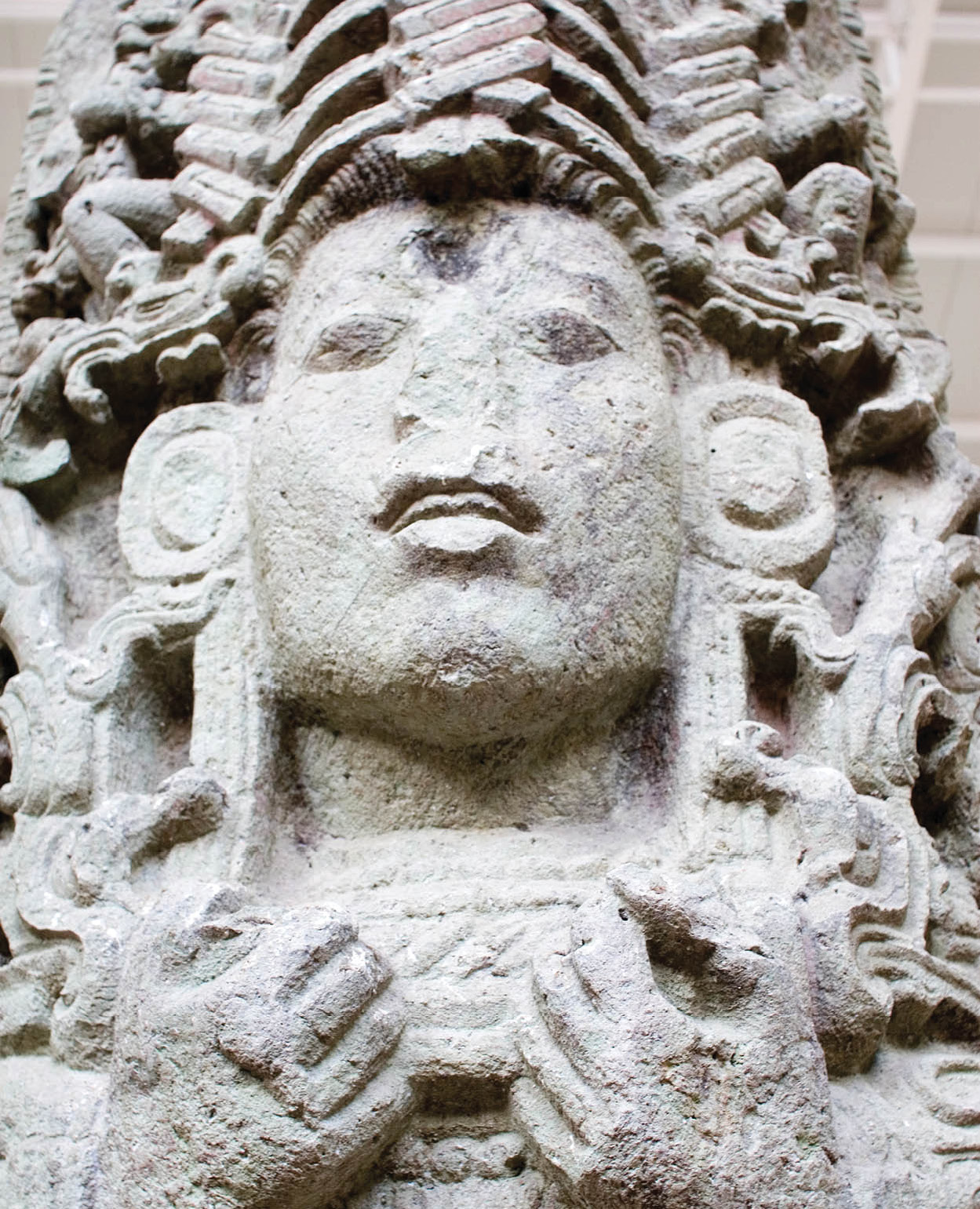
Finely carved stela at Copán.
Corrie Wingate
Its population is as diverse as its landscape: most people are ladinos, but there are a number of Maya speakers (mainly Q’ eqchi’) and also a few Garífuna people on the coast. This is a sparsely populated area, overwhelmingly agricultural and devoid of a single city. Cattle ranching, bananas, and tobacco dominate the lowland economy; coffee and cardamom are the most important highland crops.
Historically, the Motagua River that flows through the heart of the region to the Caribbean Sea was a crucial trade route. Close to the banks of the Motagua were the largest jade deposits in the entire Maya area, contested and controlled by the Maya settlements of Quiriguá and Copán . Today the ruins of both sites are essential visits for their astonishing sculptural remains.
Leaving the capital down the busy Carretera al Atlántico, the scenery is an uninspiring deforested landscape of scrub bush that gradually gives way to succulents and cereus cacti. There’s no reason to stop until the El Rancho junction, from where a good sealed road climbs into the Verapaz highlands and toward the town of Cobán.
The Verapaces
The twin departments of Baja and Alta Verapaz (vera paz meaning “true peace”) were the last part of Guatemala to fall under Spanish control (apart from Flores), such was the ferocity of opposition from the indigenous Achi tribes, and dominance was only established in 1538 after a successful “softly-softly” approach pioneered by a group of Dominican priests led by Fray Bartolomé de Las Casas.
The Verapaces contain some of the most beautiful scenery in the country, in places almost Swiss alpine in appearance; a large spread of cloud forest, home to the elusive quetzal; some of the world’s best coffee-growing country; and the fascinating market towns of Cobán, Salamá, Rabinal, and Cubulco.

Canoeing expedition, Río Dulce.
Corrie Wingate
Historic Salamá and Rabinal
Salamá 1 [map], the first of the towns in Baja Verapaz and also the capital of the department, lies some 60km (37 miles) northeast of Guatemala City. The scenery around the town (altitude 940 meters/3,084ft) is a delightful mix of productive pastoral land (everything from oranges to olives are grown) and extensive pine forests. It is a historic place set in a wide river valley with an excellent Sunday market. The 17th-century colonial church in the plaza is an absolute gem, with no fewer than 14 gilded altars, and there’s a rather dilapidated old colonial bridge on the edge of town, now only used by pedestrians.
Situated a further 19km (12 miles) west is Rabinal 2 [map], the town where the leader of the Achi tribe accepted Bartolomé de Las Casas and his Christian priests. It also has a fine colonial church, and another superb Sunday market that’s a good place to buy artesanías (handicrafts), especially ceramics. About 1km (0.6 miles) north of Rabinal are the unreconstructed Achi ruins of Cahrup – there’s not too much to see, but it makes a pleasant place for a picnic.
The final town out this way is Cubulco, famous for its July 25 fiesta, where the Palo Volador, a Maya-style bungee jump, is performed.

The beautiful quetzal.
© Aurora Photos / AWL Images Ltd
Quetzal reserve
Baja Verapaz’s other attraction is located just to the south of Purulhá, off the Cobán highway, where an area of dense cloud forest has been declared a quetzal reserve, the Biotopo del Quetzal 3 [map] (daily 6am–4pm; charge). The quetzal, once the spiritual talisman of the Maya lords, now Guatemala’s national bird, is a beautiful but notoriously elusive creature that is now very rare throughout Central America .
TIP
You can climb the 131 steps of the Calvario church tower in Cobán for a fine view of the town and surrounding countryside.
The reserve (also called the Biotopo Mario Dary, after its founder, a conservationist who was murdered in 1981 whilst fighting to protect the area from loggers) is a permanently humid patch of forest thick with ferns, epiphytes, moss, and lichen. Dawn is the best time to spot a quetzal, which feasts on the fruit of the aguacatillo (wild avocado) tree, but there are at least another 87 species of birds to look out for. A map available on site details the two trails that meander through the ever-dripping foliage. The season for spotting the quetzal is just before and after the nesting season, between March and June.
Cobán
The commercial center of the Verapaces is Cobán 4 [map], which, though founded by Las Casas in 1538, remained a slumbering backwater until the late 19th century, when large numbers of German immigrants arrived. The Germans were granted authority to plant coffee bushes, which thrived in the mild, moist Verapaz climate, and business prospered until World War II, when many of the coffee barons were expelled at the USA’s insistence because of their open support for Adolf Hitler.
TIP
At the Finca Santa Margarita , once owned by prominent German coffee grower Erwin Dieseldorff, the guided tour takes you step by step through the coffee-making process from propagation to roasting. You also have a chance to sample the different types of Arabica coffee blends, and to buy beans direct.
Tranquil Cobán has a few attractions and makes an excellent base to explore the beautiful Verapaz scenery. Though the town maintains a sleepy demeanor, there are some good-value cafes and hotels, so visitors should enjoy their stay here. Take a stroll up to the Templo el Calvario, a fine old church dating from 1599, which is popular with Q’ eqchi’ and Poqomchi’ Maya worshipers. Don’t miss the exquisite carvings and artifacts inside the small Museo El Príncipe Maya (Mon–Sat 9am–5.45pm; charge), or the chance to take a guided tour of the Finca Santa Margarita (Mon–Fri 8am–12.30pm, 1.30–5pm, Sat 8am–noon; charge), a coffee plantation 300 meters/yds southeast of the plaza.
Just out of town, 2km (1.2 miles) to the west, is the Vívero Verapaz (Mon–Sat 9am–noon, 2–4.30pm, Sun 9am–noon; charge), a specialist nursery where thousands of plants, including more than 600 species of orchid, are grown.

The stunning turquoise pools of Semuc Champey are a perfect natural water park.
Corrie Wingate
Semuc Champey
A cascade of cool turquoise and emerald-green pools surrounded by lush, tropical forest, Semuc Champey is one of eastern Guatemala’s most spectacular sights and its top tourist attraction. The Río Cahabón eventually flows into Lago de Izabal, but at Semuc Champey most of its current plunges underground, leaving a great limestone bridge at the surface. A little river water spills over this natural shelf, creating a series of idyllic pools perfect for swimming, and a magical place to relax and enjoy the magnificent natural setting (keep your valuables with you). Climb the steep path (which can be slippery in parts) on the southern side of the valley to a mirador (lookout) for an eagle’s perspective of the pools. Tour companies in Cobán run regular trips here .
Caves and lagoons
Far more dramatic, though, are the stunning natural wonders near the village of Lanquín 5 [map], situated 58km (36 miles) to the northeast. The gargantuan Lanquín caves are a speleologist’s delight, stretching for several kilometers underground, while on the banks of the Río Cahabón south of Lanquín is Semuc Champey, one of the most beautiful places in Guatemala.
TIP
There’s another large cave system close to Semuc Champey called K’anba that can be explored; hotels in Lanquín offer tours. A river flows through the cave system, so be prepared to get thoroughly wet, and it is pitch dark – tours are often conducted by candlelight to add to the atmosphere.
North of Lanquín, a poor dirt road winds through some spectacular Verapaz countryside, the first stretch almost alpine in appearance, then punctured by dramatic limestone hills as the route heads towards the Cruce del Pato junction. Near the isolated village of Raxrujá, the Candelaria caves are some of Guatemala’s most impressive and include a 200-meter (650ft) chamber known as Tzul Tacca. There is a small charge.

Exploring the spectacular caves at Lanquín.
Corrie Wingate
Heading north of Cobán toward Petén, 60km (35 miles) along a smooth highway brings you to the small town of Chisec, which has two natural attractions close by. Just 2km (1.2 miles) north of town, Bombil Pek (painted cave) is a huge limestone sinkhole, which has a tiny cave adorned with faint images of monkeys that date from ancient Maya times. Some 8km (5 miles) east of Chisec are the Lagunas de Sepalau, two stunning turquoise lakes surrounded by dense rainforest.
Another 43km (27 miles) northwest from Chisec is the Parque Nacional Laguna Lachuá 6 [map], a spectacular circular lake. Ringed by rainforest, Lachuá is idyllic, if extremely remote, and a variety of wildlife, including otters and many birds, can be seen here. There’s a good wooden guest lodge and camping facilities.
El Oriente
Lying south of the Carretera al Atlántico is another highland region, known as El Oriente. This is the hottest part of Guatemala, a relentlessly uncompromising land where the thermometer regularly nudges 38˚C (100˚F). El Oriente is ladino country par excellence, the arid, dusty terrain the natural home to campesinos, cattle ranchers, and tobacco farmers. Probing the horizon are a scattering of ancient, extinct volcanoes – though much smaller in scale and more weathered in appearance than the chain across the western highlands. You will have to cross through these eastern highlands if you plan to visit the ruins of Copán.
The main route into El Oriente branches off from the Carretera al Atlántico at the Río Hondo junction. Heading south, the first major town, Chiquimula 7 [map], is archetypal of the region – hot, dusty, and featureless. Because of its location, it is well served by buses, and has a reasonable choice of places to stay and eat. The only building of architectural interest is an old colonial church, the Iglesia Vieja, on the edge of town, badly damaged by the earthquake in 1765 and now reduced to ruins.
Continuing south of Chiquimula, down near-empty roads, is Volcán de Ipala 8 [map], a 1,650-meter (5,410ft) eroded volcano with an exquisite crater lake at its rounded summit. It is a fairly easy two-hour hike to the top from the closest village of Agua Blanca. If you have your own transportation, the most direct route is up a trail that begins at Km 26.5 on the Ipala–Agua Blanca road, near to a drinks stall in the tiny settlement of Sauce. Once here, you can walk all around the forest-fringed summit of the lake in a couple of hours.

Vicar blessing pilgrims in front of the Basilica of Esquipulas.
© Bert de Ruiter / Alamy
Esquipulas
Some 33km (20 miles) south of Chiquimula, close to the border with El Salvador, Esquipulas 9 [map] is famous as the site of the biggest pilgrimage in Central America. The object of veneration is an image of El Cristo Negro, the Black Christ, which is housed in a colossal white basilica. Inside the church the atmosphere is heady with incense and smoky from burning candles, while a continuous procession of pilgrims lines up to receive a blessing, many on their knees and reciting prayers. The image itself, created from balsam wood, was carved by the fabled sculptor Quirio Cataño in the late 16th century, while the origins of the pilgrimage are thought to predate the Conquest. The main pilgrimage date is January 15, and there is a smaller event on March 9, but Esquipulas is busy throughout the whole year with pilgrims and devotees paying homage and seeking cures to ailments.
The town itself is rampantly commercial, geared to extract as much as possible from its short-term visitors – hotel prices double on Saturdays and there’s an unholy heap of tacky souvenirs in market stalls outside the basilica.
Izabal
Fringed by the Caribbean Sea, with Belize just to the north and the Honduran coastline to the south, the low-lying department of Izabal feels totally unlike the rest of the country. The population is a polyglot assortment of ladinos, Garífuna, Caribs, and Q’ eqchi’ Maya. The scenery is also different: the landscape is lush, and the heat and humidity are punishing at any time of year, creating a decidedly languid, tropical ambience.
TIP
Boat cruises around El Golfete (usually departing from Lívingston) often stop at the hot springs that empty into the lagoon, so you can take a dip in the warm, sulfurous water. It is an idyllic spot, shaded by overhanging trees and surrounded by lush jungle vegetation.
Izabal is bounded by mountains: the Sierra del Merendón defining the Honduran border, the Sierra de las Minas to the southwest, and the Sierra de Santa Cruz to the north. In the very center of the department is Lago de Izabal, the biggest lake in the country, which drains into the Caribbean through the beautiful Río Dulce gorge. The economy has been geared around bananas for over a century, exported via the port towns of Puerto Barrios and Santo Tomás de Castilla to North America and Europe, though tourism centered upon the town of Río Dulce is also becoming more important, particularly for cruises on Lago de Izabal and El Golfete.
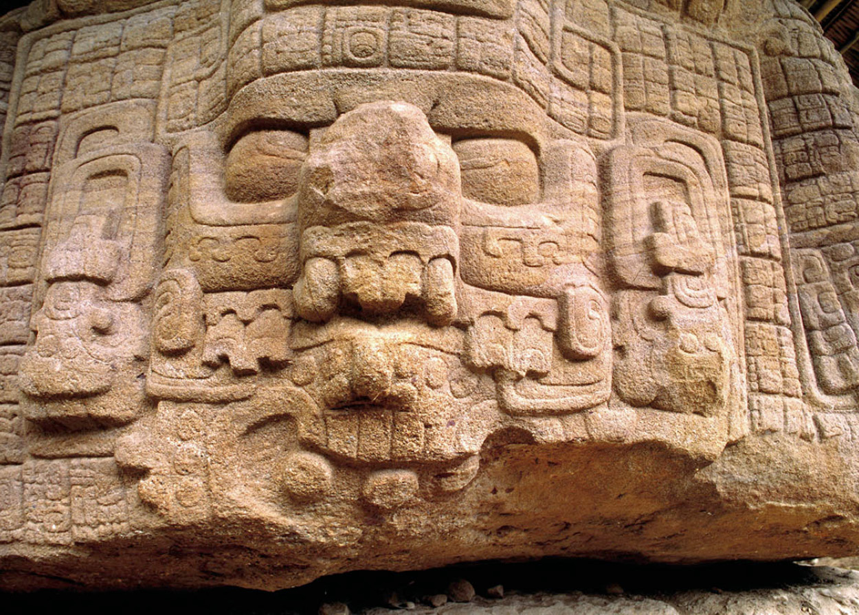
Beautiful carvings at Quiriguá.
© Craig Lovell / Eagle Visions Photography / Alamy
Quiriguá ruins
The Carretera al Atlántico follows the Motagua River through much of the department, following the ancient trade route from the highlands to the Caribbean. The early Classic ruins of Quiriguá ) [map], set in a beautiful clearing just off the highway, are well worth investigating for their remarkable stone carvings of fine-grained sandstone stelae and giant flat boulders. Quiriguá had always been a minor site, possibly first settled in the early Classic period by an elite group from the northern Maya lowlands. It was subsequently dominated by nearby Copán, but in AD 737, the leader Cauac Sky (or Two-legged Sky) captured and sacrificed Copán’s ruler 18 Rabbit, turning centuries of Maya power politics upside down.
To celebrate this success, Cauac Sky started rebuilding Quiriguá, commissioning the carving of the largest stelae anywhere in the Maya world, which were grouped around an enormous monumental plaza, enclosed on three sides by an acropolis.
The site’s largest stela is Stela E, 8 meters (25ft) tall, which depicts Cauac Sky crowned with an elaborate headdress. There are 10 other stelae in the plaza, a small acropolis to the south, and a ball court. Don’t miss the six fantastic carved boulders just below the acropolis, which are decorated with images of frogs, turtles, jaguars, and snakes, and a serene, Buddha-like figure on Zoomorph P.
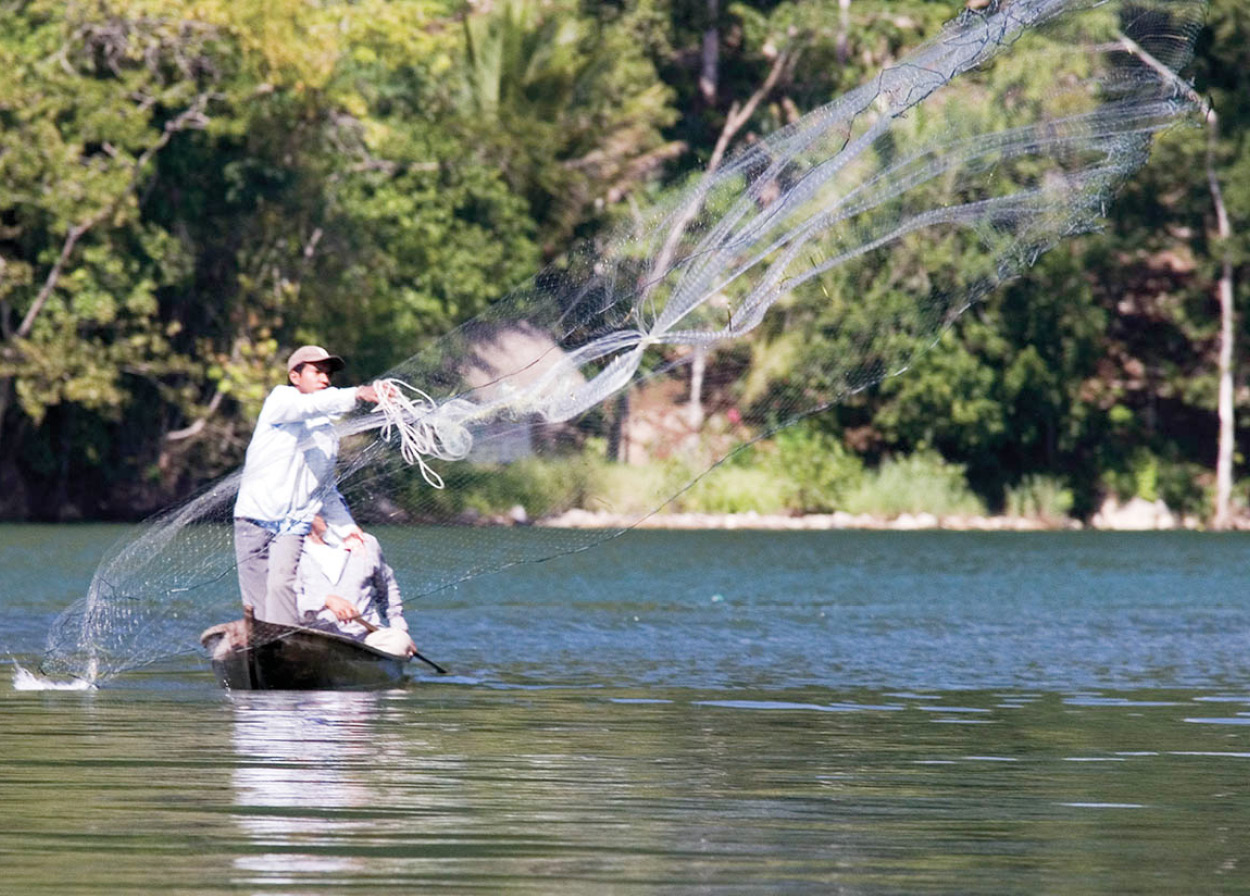
Fishing on the Río Dulce.
Corrie Wingate
Lake Izabal
North of Quiriguá is Lago de Izabal, a huge freshwater expanse which is steadily being opened up to tourism. The western environs of the lake are protected as part of the Bocas del Polochic reserve, where there are alligators, iguanas, and a riot of colorful birdlife. Most people stay at the eastern edge of the lake, however, near the massive concrete bridge, at the town of Río Dulce ! [map]. The town, scattered on both sides of the bridge, is no beauty, functioning mainly as a transport hub, but unexpectedly close by there are some delightful hotels that are well placed for exploring the lake.
Back in the 16th and 17th centuries, British pirates caused mayhem around Izabal, raiding Spanish merchant caravans, and the Castillo de San Felipe (daily 8am–5pm; charge), just 3km (2 miles) from Río Dulce town, was built to combat these marauding buccaneers. There’s a lot more to see around the lake, including an incredible hot spring waterfall near Finca El Paraíso, which drops about 12 meters (40ft) into a deep pool, and the Boquerón canyon near the town of El Estor, originally called “the store,” another reminder of English influence.
Manatee reserve
Heading toward the Caribbean from Río Dulce town, the lakeside scenery opens up again into a lagoon called El Golfete, where there’s a manatee habitat reserve, Biotopo Chacón Machaca (daily 7am–5pm; charge), though you will be extremely fortunate to see one of the huge, timid mammals. The birdlife is usually much more in evidence, so keep your eyes peeled for pelicans, egrets, kingfishers, ospreys, and herons. The banks then close in as you enter the spectacular Río Dulce gorge, its soaring 100-meter (328ft) high walls covered in impenetrable rainforest, passing a bubbling underwater hot spring.
Lívingston
At the point where the Río Dulce meets the Bahía de Amatique is the Garífuna town of Lívingston @ [map], sometimes known locally as La Buga (The Mouth). Lívingston is one of the most interesting villages in Guatemala, its atmosphere seemingly much more in tune with Jamaica or the Honduran Bay Islands than the Central American mainland. Connections with the rest of Guatemala are somewhat tentative, and not just culturally, as Lívingston can only be reached by boat from Puerto Barrios, Belize, or Honduras. With the melodic rhythms of reggae and Garífuna punta filling the village streets, it is easy to assume Lívingston is some lost laid-back Caribbean paradise. Not so – unemployment is very high, forcing many to emigrate, and allegedly more Lívingston-born men live in New York than in the village itself.
Good excursions from Lívingston include the impressive series of waterfalls called Siete Altares (best in the rainy season), the best beach in Guatemala, Playa Blanca, and even snorkeling trips to the edge of the Belizean reef system.

Fruit and vegetable production has played a significant role in the nation’s history.
Corrie Wingate
The United Fruit Company
For more than half a century, all Guatemala’s political and economic decisions were effectively supervised by the United Fruit Company, Central America’s biggest employer, and dubbed El Pulpo (“The Octopus”) because of its huge influence in the region. The UFC first began banana business in Guatemala in 1901, and quickly struck a deal to complete the Guatemala City–Puerto Barrios railroad line in exchange for almost complete tax exemption and land concessions. By 1930 the company was worth US$215 million, and its yellow tentacles controlled the country’s railroads, the main port Puerto Barrios, and consequently had control over all the country’s other exports.
This hegemony was largely unchecked until 1952, when President Arbenz drafted new reform laws, which redistributed land to peasants at a fraction of its market value. US interests were deemed to be under threat, and a plot was hatched by the CIA (whose director Allen Dulles was also on the UFC board) to support an invading force of Guatemalan exiles from Honduras, which overthrew Arbenz in 1954.
The new CIA-backed strongman, Carlos Castillo Armas, returned all the confiscated land to the UFC, which merged with United Brands in the 1960s and finally quit Guatemala in 1972, selling its remaining land to Del Monte.
Puerto Barrios
Puerto Barrios £ [map], located in the southeastern corner of Bahía de Amatique, is today little more than a transit point for tourists picking up boats for Punta Gorda in Belize or en route for Lívingston. For many years though, the town was the country’s most important port. Now it has been eclipsed by the modern facilities available at Santo Tomás de Castilla, just 11km (7 miles) to the west around the bay.
Puerto Barrios was established by president Rufino Barrios in the late 19th century, but developed by the United Fruit Company in the 1900s as the company’s exclusive port for the export of its bananas. The UFC modeled the town on urban North American lines, and it retains this legacy today, with broad streets and sprawling city blocks.
Most of the old wooden Caribbean buildings are crumbling and dilapidated now, unfortunately, replaced by faceless concrete constructions. The odd reminder of more prosperous times remains, however, and the town’s one real sight is the atmospheric Hotel del Norte, right on the waterfront, an immaculately preserved – and charming – living monument, built entirely from wood.
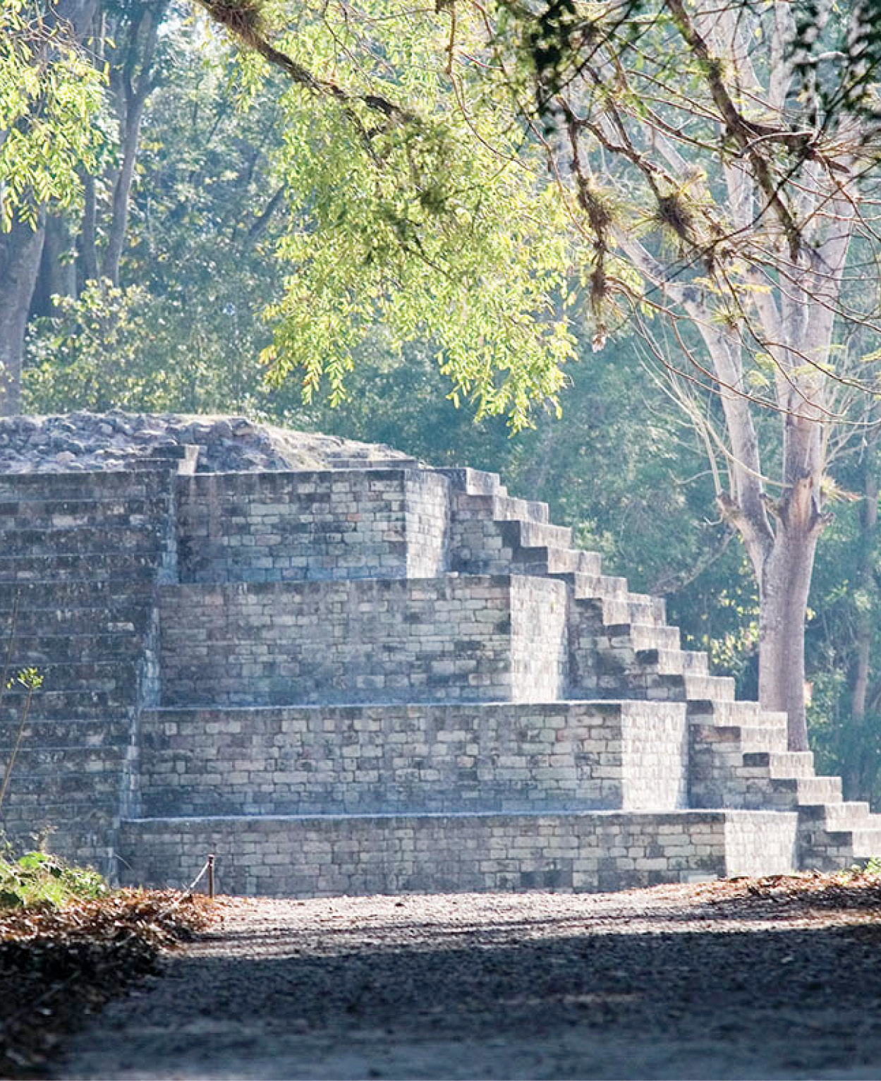
In the Great Plaza at Copán.
Corrie Wingate