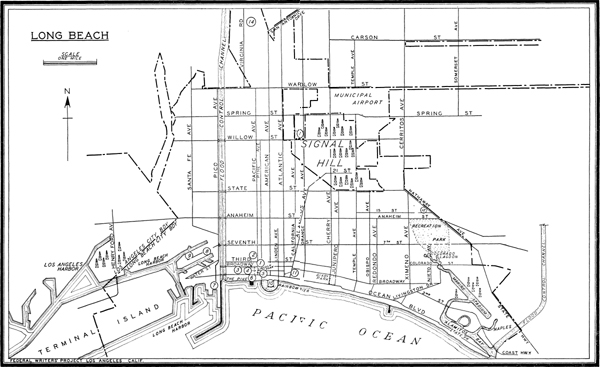
Railroad Station: Pacific Electric Ry., 156 W. Ocean Blvd.
Bus Stations: Union Bus Depot, 226 E. 1st St., Greyhound Lines, Motor Transit Lines, Motor Coach Lines; Central Bus Depot, 56 American Ave., National Trailways, Santa Fe Trailways; Union Pacific Bus Station, 49 American Ave., Union Pacific Stages, Interstate Transit; All-American Bus Lines, 222 E. 1st St.
Airport: Long Beach Municipal Airport, 3301 E. Spring St.
Piers: Municipal Pier No. 1, Channel No. 3 Inner Harbor (Pico Ave. and Water St.), Los Angeles and San Francisco Navigation Co. ships to San Francisco Tues, 5 p.m. Municipal Navy Landing, between Piers A and B, outer Harbor; visits to warships Sun. and national holidays, by Navy shore boats, 2-4 p.m., free; by water taxi, 50¢ round trip. Charter boats for harbor trips at most piers.
Taxis: Rates by zones and meter; minimum charge, 15¢.
Streetcar and Bus Service: Streetcar, 6¢; bus, 5¢.
Traffic Regulations: Meter parking zone, Ocean Blvd. to 7th St. between and including Pacific and American Aves., 5¢ per hr.; 2-hr. limit in business district outside meter zone. State traffic laws prevail.
Streets and Numbers: Avenues run N. and S., streets E. and W. Numbers E. and W. from Pine Ave., N. and S. from Ocean Blvd.
Shopping District: Between Pacific and Atlantic Aves., from Ocean Blvd. to 7th St.
Information Bureaus: Chamber of Commerce, 109 American Ave.; Travelers’ Aid, 156 W. Ocean Blvd.; City Hall, Pacific Ave. and Broadway; Public Library, Lincoln Park, Pacific Ave. and Ocean Blvd.
Newspapers: Press-Telegram, eve. and Sun.; Sun, morn. except Sun.
Radio Stations: KFOX, 220 E. Anaheim St., KGER, 435 Pine Ave.
Churches: 98 churches and other places of worship, representing most denominations and creeds.
Accommodations: 88 hotels, 1,375 apartment houses and courts, numerous auto and trailer camps. Wide range of rates.
Theatres: 21 motion-picture houses, principally in downtown business district and amusement zone.
Parks and Playgrounds: 24 public parks and playgrounds totaling more than 980 acres. Almost all types of recreational facilities and equipment available.
Swimming: 8 miles of beaches; still-water swimming at Marine Stadium, Alamitos Bay, and lagoon enclosed by Rainbow Pier at foot of American Ave.; salt-water plunge, Colorado Lagoon, Recreation Park; adm. free; indoor plunge at foot of Pacific Ave.; adults 40¢, children 30¢.
Golf: Recreation Park (municipal), E. 7th St. and Park Ave., 2 courses, 9 and 18 holes, green fees 50¢ and 75¢ daily, $1 Sun., holidays; $5 per mo.; Lakewood Country Club (open to public). Cherry Ave. and E. Carson St., 18 holes, fees 75¢ daily, 50¢ before 8 a.m. and after 3 p.m.; Meadowlark Country Club (open to public), Coast Hwy. at Sunset Beach, 18 holes, fees 50¢ daily.
Tennis: 10 municipal courts, 2 lighted. 23 school courts open to public after school hours.
Fishing: Surf and pier fishing permitted. Boats from Pier B, foot of Santa Clara Ave., daily at intervals from 2-7:30 a.m., returning about 3:30 p.m., $2-$3 per day. Barges reached by boat from Belmont Pier, foot of Belmont P1., daily 8 a.m.-3 p.m. at 1½-hr. intervals, $1. (All prices include bait and tackle.)
Annual Events: See Los Angeles Calendar of Events.
Railroad Station: Pacific Electric Ry., Los Angeles-Newport Beach Line, on private right-of-way, between Walnut and Cherry Aves.
Bus Station: Lang Bus Co., Clearwater-Long Beach line stops on signal at Cherry Ave. interstections.
Taxis: Taxis on call from Long Beach stands. Long Beach zone and meter rates prevail.
Traffic Regulations: State traffic laws prevail.
Streets and Numbers: Avenues and streets in the level area south and west of the hill are continuations of Long Beach thoroughfares. Avenues run N. and S., streets E. and W.
Information Bureau: Signal Hill City Hall and Justice Court, Cherry Ave., between 21st and Hill Sts.
LONG BEACH (47 alt., 164,271 pop.), a seaside resort, a busy harbor, home port for some 40,000 officers and men of the U.S. Navy, and one of the world’s great oil centers, stretches for eight miles along San Pedro Bay. The fifth largest of California’s cities, it lies 20 miles southeast of Los Angeles. Along the ocean is the long beach for which the city was named—a wide band of white sand, to which come hundreds of thousands every year to bask in the sun, swim, dive into the curving breakers, row or sail boats, and fish from piers or barges anchored offshore. Along the strand, at the foot of Pine Ave., the city’s main street, is the Pike, a raucous amusement area, with roller coasters, side shows, hot dog stands, and similar attractions; staid townspeople rather frown upon it as rowdy and noisy, but they overlook this for the sweet music played by tourists’ and children’s dimes and quarters as they clink at the change booths.
To the west, set off by the Los Angeles River, is the industrial section and the harbor, protected by a breakwater built in 1928. It consists of both an inner and an outer harbor, dredged to accommodate ocean-going ships; marine traffic approximates $50,000,000 a year. Close to the wharves are some 400 industrial plants which produce gasoline and other petroleum products, canned fish, clothing, tools, soap, vegetable oils, and ships. Offshore, for many months of the year, lies the U.S. Battle Fleet, a formidable steel-gray armada by day, at night an eerie line of blinking lights cut by beams of powerful searchlights. The fleet is an important factor in the city’s economic life. Almost all of the officers maintain homes in Long Beach, and thousands of blue jackets visit the city regularly on shore leave.
To the east are parks, the newer residential sections, eucalyptus groves, and the lagoons of Alamitos Bay, as the city trails off into open country. On the north, bristling with tall oil derricks, rises Signal Hill, the center of an independent municipality of the same name.
The downtown district of tall office buildings and hotels, shops and theatres, extends northward from the beach along Pine and other streets. Beyond, the city is laid out in rigid rectangular pattern, squared to the main points of the compass; cafes, garages, used-car lots, stores, and markets line the main thoroughfares; along the quiet side streets, shaded by palm and pepper trees, stand frame and stucco bungalows, for the most part, although there are many larger and more elaborate white stucco houses along East Ocean Blvd., which swings in an arc on the yellow bluffs above the beach, and on the sandy slopes overlooking the ocean, lagoons, and winding canals around Alamitos Bay.
Much of the architecture reflects the origin and the ideals of the elderly Midwesterners, who constitute a large part of the population. The annual Iowa Picnic held in Bixby Park attracts more than 100,000 people. Having come here to spend their declining years, they are conservative, Protestant, church-going, and home-loving, although venturing forth frequently to attend Sunday School picnics and Ladies’ Aid bazaars. They are inveterate “joiners,” supporting some 200 civic and social organizations. Many men play horseshoes daily in Lincoln Park, while others join heated sessions of the “Spit and Argue Club” on the Municipal Pier, to discuss politics and religion. For many years dancing, card playing, drinking, and modern bathing suits were regularly and vehemently denounced here, with no appreciable effect on the younger generation, which, unimpressed by jeremiads on fire and brimstone, went its own light-hearted way and here, as elsewhere, the “shocking” has now become usual. Since the depression the traditional political conservatism of the older generation has broken down, shipwrecked on the hard rock of reality, for many a retired farmer, tradesman, and country doctor found his savings of a lifetime wiped out in the economic collapse. It is no accident that Dr. Francis E. Townsend, an elderly local doctor from the Middle West, started his old age pension scheme here.
In 1784, three years after the establishment of the pueblo of Los Angeles, Governor Pedro Fages began to distribute land in the name of the King of Spain and to one Manuel Nieto, a soldier, allotted all the land between the Santa Ana and San Gabriel Rivers, a grant of 300,000 acres, extending from the sea to the northeastern foothills; the grant was later split into five ranchos. On Nieto’s death, Don Juan José Nieto, his son, succeeded to Rancho Los Alamitos (the little cottonwoods), and Dona Manuela Nieto inherited Rancho Los Cerritos (the little hills); these two ranchos embraced the present site of Long Beach.
In 1840 Abel Stearns (see The Historical Background) bought Rancho Los Alamitos, and three years later John Temple, a Los Angeles merchant, became the owner of Rancho Los Cerritos through his marriage with Dona Rafaela Cota, descendant of Don Manuel Nieto. The two Massachusetts Yankees lived as Spanish dons and were the only ranch owners in the entire district. They became friendly rivals, and staged barbecues, rodeos, and bullfights, as well as an annual inter-ranch horse race, the course running from Signal Hill straight to the sea. But the drought years of 1862-64 put an end to the prosperity of the two Yankees; during those years, it is said, 50,000 cattle died on Rancho Los Alamitos alone. Stearns and Temple mortgaged and sold their properties, and by 1878 all of what is now Long Beach had passed into the hands of the Bixby family.
In 1880, W. E. Willmore, an Englishman, secured an option from Jotham Bixby on 4,000 acres, organized the “American Colony,” and advertised Willmore City, as he called it, throughout the nation. He offered 5-, 10-, 20-, and 40-acre farms at $12.50, $15, and $20 an acre; and at $100 an acre he offered 3-or 4-year-old orange trees, 70 to the acre. The venture failed, however, and in 1884 Willmore relinquished his option. But the plans of the city remained, for it had been surveyed and laid out in 1882, with its present streets and Pacific Park.
The Long Beach Land and Water Company then took over the settlement, renamed it Long Beach, improved the water system, built a hotel and wharf, instituted a horse-car line, and connected the town with the Wilmington line of the Southern Pacific. Thereafter development was rapid. During the boom of the 1880’s Long Beach became a popular seaside resort. With the completion of the Pacific Electric Railway line to Long Beach in 1902 its growth became even more rapid. In 1908 Long Beach adopted its first charter, which provided for a mayor and council form of government. This was succeeded in 1915 by a commission plan; and the present managerial system, under which a city manager is appointed by the council, was adopted in 1921.
In 1906 the Los Angeles Dock and Terminal Company, organized locally, developed the inner harbor by dredging channels and building jetties, and three years later John F. Craig established the first large shipyard in southern California, and dredged a channel from it to the sea. Plans to develop a large port were facilitated in 1911 when the state granted to Long Beach all tidal flats and submerged lands along its boundaries. In 1917 the Los Angeles Dock and Terminal Company deeded all its navigable channels to the city, and the next year Federal development of the harbor began. Shipping was highly stimulated in 1921 by the discovery of a phenomenally rich oil field on Signal Hill. A further grant of tidelands along the extended boundaries of the city was made in 1925, and Long Beach developed into an important port and naval base.
The Long Beach earthquake of 1933, in which 118 persons lost their lives and $40,000,000 worth of property was damaged in Long Beach and the surrounding communities, only momentarily broke the city’s stride. This earthquake, the second most destructive in the history of the United States, began about dinnertime on March 10 and continued with lessened violence for several days; it was produced by a fault slip in the ocean off Newport Beach. Long Beach, like other communities in the devastated area, had most of its schools leveled by the shock. Faulty building construction was responsible for much of the damage; steps have been taken to see that such a condition does not exist in the future.
SIGNAL Hill (364 alt., 3,184 pop.), a small independent municipality, economically a part of Long Beach, occupies the hill down which Don Juan Temple and Don Abel Stearns once started their horses in races to the shore and back again. Streets and roads wind through a forest of oil derricks, with here and there a cluster of cottages near grimy palm trees.
Here, on June 23, 1921, a discovery or “wildcat” well driven by the Royal Dutch Shell Company came in, but like many discovery wells, with a small production. By the end of the year some 500 greasy derricks spindled skyward; by midyear 1922, 500; by the end of 1923, more than 1,000 on an area of little more than two square miles, making the field one of the most intensively developed in the world. Almost overnight, “million dollar views” became million dollar leases as production mounted to a daily average of almost 250,000 barrels. Thousands poured in to work in the field or to speculate in leases; there was a frenzied boom in surrounding real estate. Within two years the number of ships using the Panama Canal was doubled by the increase in tankers carrying California oil. Los Angeles became one of the great oil ports of the world. Within a decade the population of Long Beach tripled as the flow of “liquid gold” from Signal Hill was piped to its wharves and refineries. The field reached its peak production in 1923 with sixty-eight million barrels, the output for the first ten years being more than four hundred million barrels. Since discovery it has remained one of the largest producing oil fields in California.
After the completion in 1859 of the Drake well, the first in the world, at Titusville, Pa., prospectors sought likely localities around the oil and tar seepages and natural asphaltum deposits in Humboldt, Santa Barbara, Los Angeles, and Kern Counties. By 1867 some 50 wells had been drilled but produced only 5,000 barrels of oil, valued at $10,000. In 1873, C. A. Mentre, a Pennsylvania driller, secured leases in Pico Canyon (see Tour 7), and with primitive equipment drilled a hole 30 feet deep, from which oozed a barrel or two of oil a day. In 1883 the production of crude oil in the State totaled a mere 2,500 barrels a day.
The Brea-Olinda field (see Tour 4), the first in the Los Angeles Basin, was opened in 1897; up to 1919 new discoveries in the Los Angeles Basin were confined to the eastern section of Los Angeles County and the northwestern corner of Orange County, consisting of the following fields: Whittier and Coyote, 1912; Montebello, 1917; Rich-field-Yorba Linda, 1919; Santa Fe Springs, 1919.
In 1920 development shifted to the coastal strip of Los Angeles and Orange Counties, where 13 new fields were opened prior to 1937. The field at Huntington Beach (see Tour 5), discovered in May 1920, followed on June 23, 1921, by Signal Hill, were among the richest ever discovered. The upper sands in the field were soon depleted, but late in 1923 other oil-bearing sands were struck below 5,000 feet, and derricks spread northwest to the Chateau Thierry district and southwest to Reservoir Hill; in 1938 a well was brought in at 10,000 feet. The extraordinary depth of the sands account for the phenomenal aggregate production per acre of the Signal Hill field. The 21 fields in the Los Angeles Basin produced more than half of the State’s 250,000,000 barrels of crude in 1938, which represented more than 12 per cent of the national and roughly 8 per cent of the world total. At the same time the fields supplied 267,292,000,000 cubic feet of natural gas.
Refining of crude oil constitutes the greatest single division of industry in Los Angeles County; its 35 refineries had an output in 1937 valued at $228,500,000. In addition, 52 plants produce casing head gasoline from natural gas by a process of evaporation and condensation. This process was discovered in 1911 when it was found that in a gas pipe line laid along the bottom of the Los Angeles River gasoline accumulated in those sections of pipe under water but not at other points on the line. Crude oil is refined by a heating process, which boils out gasoline, kerosene, gas oil, lubricating oil, fuel oil, wax, and asphalt, each of which vaporizes at a different temperature; during the process temperatures range from 200 to 575 degrees. Crude oil is graded by its specific gravity; the higher the gravity, the greater the gasoline, kerosene, and naphtha content. Los Angeles Basin crude oil brought an average price of 99 cents a barrel in 1938.
Drilling was begun on the ocean floor in 1894, and derricks rise in the waters west from Long Beach to Wilmington. Drilling for oil is not the haphazard business it once was. The geologist, paleontologist, and geophysicist have reduced it to a science by a study of the conditions under which oil is likely to be found. It remains for the drill, however, to prove the accuracy of their deductions on the possible presence of oil in untested territory. Many a well driven at their advice has been a “duster,” or dry hole.
When a “wildcat” well is to be driven to test a suspected field, a derrick is erected over the chosen spot; most derricks in the Los Angeles Basin are of the combination-rig type, 122 feet high, of wood or steel; steel is frequently required by law in fields lying within incorporated limits of a town or city, to lessen fire hazard. For wells deeper than 6,000 feet—some go down as far as 14,000 feet—huge derricks of 200 feet or more are used. When the derrick has been completely rigged with machinery, boilers, cables, and crown block of wood or metal, fitted with large pulleys, the well is ready to be “spudded,” either with a drill that bores into the earth or with a percussion drill that literally pounds its way down. After a depth of 100 to 200 feet has been reached, the drill is withdrawn and a casing is inserted to wall the hole, and this process is repeated at regular intervals.
Operations are interrupted now and again by the necessity of doing a “fishing job” to recover drills or casing lost in the hole. In the coastal area, where subterranean channels of sea water are sometimes encountered, cement is forced down the hole under high pressure; when it hardens, it forms a solid plug, through which the well is then bored. The entire procedure is supervised by a driller, who operates the engine, while “roughnecks” handle pipe, make connections, pull and place slips. A drilling crew works 24 hours a day, in three shifts, called Tours, pronounced “Towers.”
When the driller believes that oil sands have been reached, the drill bit and pipe are withdrawn, and an oil string, of “perforated,” is inserted. Gas pressure forces oil through the small perforations and up the pipe. As mud and water are bailed out and dumped into the slump hole, the gas gradually lifts the oil toward the surface until it boils out of the casing mouth to be piped to tank farm or refinery. On occasion, however, the gas pressure is such that when the drill is withdrawn, a column of oil spouts into the air to “paint the crown block.” These gushers are often difficult to control, but are not to be compared with “outlaw” gas wells. When a drill breaks through the thick “cap rock” over an oil pool, the force of the escaping gas sometimes crumples a derrick as if it were built of matchsticks; it may develop into a burning “gasser” if rocks and pieces of cement strike the casing and throw off a spark. Such “outlaws,” which have not destroyed the casing head and control valves, are tamed by the use of long rods attached to the controls. Behind a protective shield, workmen manipulate these bars until the pressure is reduced sufficiently to permit a crane to drop a heavy metal “cap” over the casing. Where valves cannot be worked by remote control but the casing head is still intact, a crane is brought into position and a forty-foot flue is set over it. This elevates the flame to a height where workmen can approach the well and install a control manifold and shut off the flow. In cases where the casing head is destroyed, the modern practice is to drill a vertical hole to a certain depth in the vicinity of the “wild” well and then “whipstock” at an angle until the “outlaw” is tapped. Liquid mud, under heavy pressure, is then pumped into the well until it stops the flow of gas or oil.
The cost of drilling a well varies with geologic conditions, depth, and mechanical difficulties. The average well strikes oil at 4,100 feet and costs approximately $45,000. In fields such as Signal Hill, where properties are numerous and small, many of the wells are uneconomical from any broad point of view. An oil pool is a geologic and economic unit, but is not developed as such. Legally, every producer owns all the oil under his property, but oil is no respecter of property lines and flows toward the nearest well. In self-protection, therefore, producers drill “offset” wells around the edge of their properties to prevent them from being drained by neighboring wells, thus doubling and tripling the number of wells that would be required by any sensible and rational system of exploitation.
Signal Hill, resembling an aroused porcupine, bristles with derricks, in the shadow of which are tanks, engine houses, machine shops, and a few grimy cottages occupied by oil workers. At night the bright lights on the derricks turn the hill, often referred to as “The Pincushion,” into a curious, gaunt, illuminated forest.
POINTS OF INTEREST
The CIVIC CENTER includes the City Hall, the Municipal Utilities Building, and the Veterans Memorial Building, which front south toward Lincoln Park on Broadway, between Pacific and Cedar Avenues; the Public Library is in the park itself, facing Ocean Boulevard.
1. The CITY HALL, NW. corner of Broadway and Pacific Ave., facing Lincoln Park, is a modern eight-story building of buff-colored concrete, designed by Horace W. Austin and completed in 1934.
2. The VETERANS MEMORIAL BUILDING, on Broadway west of the Municipal Utilities Building, is a four-story, concrete structure of modern design with a decorative frieze above the entrance. The building, completed in 1938, was designed by George Kahrs; the frieze, by Merrell Gage.
LINCOLN PARK, bounded by Broadway, Ocean Blvd., Pacific, and Cedar Aves., is shaded by 50-year-old pepper and eucalyptus trees. Roque and horseshoe courts contribute to the popularity of this downtown retreat; the Long Beach Tourist Horseshoe Club uses the 10 courts daily. This pioneer playground, originally set off as Pacific Park in the early plats of Willmore City, was donated to the city by the Long Beach Land and Water Company in 1888. Its name was changed to Lincoln Park in 1915, at the unveiling of the Lincoln Monument.
3. Lincoln Park assumes the character of an Old World square on mornings when the MUNICIPAL MARKET (Tues., Thurs., and Sat., 7-12), conducted by the city as a public convenience, takes over half the width of both Broadway and Pacific Avenue, on two sides of Lincoln Park. Canvas stalls on the sidewalks display local, state, national, and foreign produce—fruits, nuts, jellies, vegetables, homemade butter, and cottage cheese. Green-tinted duck eggs, chickens and ducks, roasted a rich brown and ready to serve, are sold by the Chinese. Italian fishwives offer filets of yellowtail, sea bass, and barracuda, dressed with olive oil and cured in the sun before smoking. From 15 to 20 different nationalities are represented. Supervised by the City Market Master, who prohibits ballyhoo and barkers, the market and its products are subject to rigid inspection; in general, prices are low, and quality high. The market was established in 1913 and is sponsored by the Woman’s City Club.
POINTS OF INTEREST
4. The PUBLIC LIBRARY, in the center of Lincoln Park, built in 1908 with the aid of an Andrew Carnegie grant, was remodeled in 1936-37 by D. E. Herrald on modern lines to harmonize with other Civic Center buildings.
5. To the south of the library is the 15-foot LINCOLN MONUMENT, a life-size granite figure of the martyred president by Peter Bisson, erected in 1915 by means of private contributions and public funds.
The PIKE, an amusement zone extending almost a mile along the beach west of the intersection of American Ave. and Ocean Blvd., has appropriately been called the “Walk of a Million Lights,” and is a major local “industry.”
6. Midway along the Pike is the Silver Spray Pier, and the MILLION-DOLLAR BATHHOUSE (rates 30¢ to 40¢), with an indoor salt-water plunge. Shooting galleries, penny arcades, a roller coaster, side shows, a merry-go-round, miniature automobiles, power scooters, and similar amusements attract children and adults alike. Curio shops offer Mexican hammered silver, pottery, and needlework; Chinese, Japanese, and East Indian brass work; Spanish embroideries and Italian laces; native Indian basketry, shell, and beadwork. Among annual events are the Baby Parade, the Bathing Beauty Contest, the Pet Parade, and the Doll Fiesta. New Year’s Eve, Hallowe’en, and Fourth of July are celebrated here by vast crowds of costumed merrymakers.
7. The MUNICIPAL NAVY LANDING, at the foot of Pico Ave. in the Outer Harbor is the clearing station for enlisted men’s shore boats, officers’ gigs and numerous water taxis, plying between shore and the vessels of the United States BATTLE FLEET (open to public Sun. and holidays 2-4; transportation on Navy shore boats free), seen lying at anchor some two to three miles offshore, in the Outer Harbor, much of the year. When the fleet is in 45,000 officers and men swarm ashore at the San Pedro (see The Harbor) and Long Beach Navy landings.
Over the waters when the fleet is in, flash burnished launches carrying officers and open shore boats, crowded with sailors and marines. The dock is thronged with the families and friends of officers and men, as they arrive on liberty or leave for their ships. On the wharf of the landing are Roosevelt Post Office, water-taxi ticket offices, Red Cross and Navy Patrol stations, and quarters of the Navy storekeeper.
Los Angeles Harbor is the base of major units of the fleet, including the flagships of the commander-in-chief, and the commanders of the Battle, Base, and Scouting Forces. Regularly stationed here are 14 battleships and two airplane carriers of the Battle Force; 16 heavy cruisers of the Scouting Force; the hospital ship U.S.S. Relief; and repair ships, mine sweepers, oilers, and supply vessels of the Base Force. The battleships displace tonnages of 27,000 to 32,500 each, and carry main batteries of 14-to 16-inch guns, supplemented by six-inch secondary and five-inch anti-aircraft batteries. Each carries 60 officers and 1,200 men. The aircraft carriers U.S.S. Lexington and U.S.S. Saratoga each carry 80 planes of varying types.
The fleet was first based here in 1919, when a portion of the Atlantic Fleet was detached for service in this area in response to insistent demands for more adequate defense on the Pacific coast.
8. The SMALL BOAT ANCHORAGE, head of Slip No. 3, just off Pico Ave., is the home port of numerous yachts and cruisers discarded by wealthy owners, and motorboats of every type. On the shores of the slip are small shipyards.
9. The PROCTER AND GAMBLE COMPANY PLANT (open workdays 9:30-10:30 and 2-3; guides provided), 1601 W. 7th St., occupies a group of six-story concrete structures, on a 15-acre site fenced from the street. Visitors can observe the complete process of manufacturing soap from vegetable oils, chiefly cocoanut, cottonseed, and linseed.
10. The MUNICIPAL AUDITORIUM, occupying an eight-acre filled-in area at the foot of American Ave., is a $3,000,000 reinforced concrete structure, with Indiana limestone facing, rising to a height of nine stories. The building, light brown in color, is designed in the Italian Renaissance style with a monumental arched loggia on the front facade and a circular, arcaded bay at the rear. Italian marble has been used in the interior lobbies, and the foyer floors are of terrazzo. A main convention hall, two smaller convention halls, a concert hall, six committee rooms, and an exhibit hall bring the total seating capacity to 8,600. Surrounding gardens contain palm trees, semitropical horticultural specimens, paneled lawns, and spacious flower beds. The building and grounds project into a wide lagoon which in turn is enclosed by an encircling pier. The auditorium, designed by MacDowell and Austin and completed in 1932, is the center for varied activities: Municipal Band concerts, the weekly Sunday morning meetings of the world’s largest men’s Bible class, the annual Navy Ball, symphony orchestra concerts, and the annual Art Festival; the weekly Community Service Programs include community singing, a stage program, and old-time square dancing.
A tile mosaic, Recreation in Long Beach, designed by Nord, King, and Wright, and executed by 40 artists and craftsmen of the Los Angeles Federal Art Project, rises from the fifth story, and is said to be the largest tile mosaic in the world. At night the auditorium is illuminated by powerful floodlights.
Less than a mile west of the Rainbow Pier and the ocean-front amusement zone is the HARBOR DISTRICT. Ocean Boulevard, Broadway, and Seventh Street lead directly to the port from the city’s downtown business center, and Pico Avenue penetrates the area from the north.
The inner harbor consists of Cerritos Channel, opening into the East Basin of the Los Angeles Harbor, and two branches, Slips Nos. 2 and 3, extending 3,000 feet eastward. The main channel and the two slips provide nine miles of water frontage. Municipal piers in the inner harbor have 3,600 feet of dockage; those in the outer harbor provide an additional 3,500 feet. Black steamship funnels, swinging cranes, slender factory smokestacks, steel struts carrying power cables, and modern steel oil derricks reveal the mutiplicity of activities in the Long Beach Harbor.
The whole Long Beach Harbor area has been created from half submerged tidelands and low flats at the mouth of the Los Angeles River. Sloughs north of the present Terminal Island formerly carried the main currents to the ocean. In times of flood the river waters washed over the entire flat as far as San Pedro. The deepest of the sloughs have been opened and deepened to form the inner harbors of Los Angeles (see The Harbor) and Long Beach.
The first development work followed the establishment of the Craig shipbuilding plant south of the river mouth, now Slip No. 3 of the inner harobr, in 1907. Work was begun on an ocean entrance to the channel and a high tide, in June 1909, finished the work, opening the slough to the sea. Within three months Long Beach voted a bond issue of $245,000 for the purchase of 2,200 feet of water frontage on the channel and the construction of a municipal wharf, and in 1918 Congress provided for the dredging of Cerritos Channel. Construction of the Long Beach jetty, completed in 1928, made possible the development of the outer harbor.
RAINBOW PIER (open to pedestrian and vehicular traffic), with entrances at both Pine and Linden Aves. on the shore front, describes a 3,800-foot crescent around the Auditorium’s lagoon. The pier, completed in 1931 at a cost of $1,400,000, rests on a rock breakwater and is a vantage point from which to observe water carnivals on the 32-acre lagoon, which also offers ideal still-water bathing. The Long Beach Recreation Commission maintains a supervised recreational program here, including canoeing and various aquatic classes for children.
11. The WAYSIDE ART COLONY, 74 Atlantic Ave., occupies a group of eight brown frame buildings—art shops, studios, and private art schools—in a rustic setting. Activities of the artists, who call themselves “crafters,” include wood and metal work, painting, weaving, needlework, music, and dancing.
BIXBY PARK, two city blocks bounded by Ocean Blvd., Broadway, Cherry and Junipero Aves., has wide rolling lawns thickly shaded by live oak, pine, cypress, acacia, sycamore, and palm trees. In the 10-acre park are held many of the state picnics for which Long Beach is renowned. The Iowa picnic on the second Saturday in February is attended by 75,000 to 100,000 former residents of the Hawkeye State. In the park’s eastern section are playground apparatus, bandstand, tables and shelters, and a house where food and coffee are heated by attendants (free). The park was created in the 1880’s when the town-site was laid out, partially under the direction of John W. Bixby, for whom the plot was named, and was deeded to the city in 1903.
ALAMITOS BAY, eastern termination of Ocean Blvd., a popular spot for aquatic sports, covers the old tidal channels through which the San Gabriel River found an outlet to the sea. The bay provides seven miles of landlocked waterways, offering splendid harborage for small craft and still-water bathing. Most of the south and west shores are publicly owned, and contain a number of supervised playgrounds. The 37-acre STATE PARK, one of the bay playgrounds, under lease from the State of California by the Long Beach Recreation Commission, extends to the tip of the peninsula and has 6,000 feet of beach, on both the ocean and bay side of the spit; the bay side is protected from high tides by a 200-foot rubble wall four feet high.
The labyrinth of canals of NAPLES, a section of the Alamitos district lying west of the Vista del Golfo arm of the bay, and reached by way of Second Street, are fed by the tidal currents of the bay. Along the canals are hundreds of attractive houses, set among green lawns and tropical vegetation. Arched bridges, like those of Venice, span the waterways and provide access to the islands.
The OLYMPIC MARINE STADIUM, Colorado St. and Nieto Ave., was constructed for the rowing races in the 1932 Olympiad. The course is 2,000 meters, or 1.31 miles; a boathouse has showers and physican’s quarters; grandstand and bleachers seat 20,000 spectators. High school physical education classes in rowing are conducted at the stadium, and a model yacht championship regatta is held annually, with some 100 small vessels as entries.
The 81-acre COLORADO LAGOON, south of Recreation Park, affords exceptional facilities for water sports. In the model boatshop, in the clubhouse, many types of miniature craft are constructed under the direction of expert instructors, and an annual exposition is held each April to exhibit the work of amateur shipbuilders.
In RECREATION PARK, 7th St. and Ximeno Ave., is held an annual Twelfth Night celebration at which the city’s discarded Christmas trees are consumed in a huge bonfire. The park, with a fine expanse of lawns and distinctive eucalyptus woodland, contains children’s playgrounds, baseball diamonds, bowling greens, clubhouse, barbecue pits, coffee house, and a flycasting pool, a sport rarely provided for. 12. The central and oldest part of the ADOBE LOS ALAMITOS, NW. corner 15th St. and Hathaway Ave., is believed to have been built in 1784 by Manuel Nieto, then 70 years old, as a home for his 16-year-old bride. Set in a semitropical garden on a hilltop, the adobe retains the atmosphere of the Spanish inspiration. The two-story unit and the two wings are finished with offwhite plaster. The left wing is part of the original adobe, with walls about three feet thick. Clay from the adjacent wet lands was employed in making the large adobe bricks.
At the time of construction Nieto had acquired 300,000 acres of land, later known as the Rancho Los Alamitos (ranch of the little poplars), which extended from the Los Angeles River to the Santa Ana River, and as far inland as he could push it without conflict with the prior claims of the Pueblo of Los Angeles and the San Gabriel Mission. In 1840 Abel Stearns (see Downtown Los Angeles), a Massachusetts Yankee, purchased the rancho and transformed the old mud hut into a summer home for his bride, Arcadia Bandini, and in 1878 John W. Bixby, who had leased part of the ranch, further restored and enlarged the house. The estate now covers 3,700 acres. Near the house is an ancient Indian kitchen midden, or shell mound.
The LONG BEACH MUNICIPAL AIRPORT, Temple Ave. and Spring St., comprising 588 acres, has two paved runways illuminated at night by floodlights. The revolving beacon is visible from 20 to 80 miles. Buildings include hangars and the administration offices, and both the Army and Navy maintain hangars. The airport, established in 1924, was among the first civic aviation fields in California.
SIGNAL HILL, one of the world’s richest oil fields, rises at the northern limits of Long Beach, and is unmistakably identified by the hundreds of oil derricks that encircle and crown it. By 1938, 598,-673,732 barrels of oil and 803,342 million cubic feet of natural gas had been taken from the 1,350 proven acres of the field, a source of wealth to thousands.
13. The four-acre OLD LONG BEACH CEMETERY, NW. corner of Willow St. and Orange Ave., has many headstones, yellow with oil and age, inscribed with the names of many of the pioneer families of Willmore City. Close to the east boundary is an oblong gray granite slab in memory of W. E. Willmore, “founder of Willmore City, later incorporated as Long Beach. Died Jan. 15, 1901. Age 57.” Along the north edge of the graveyard, a stone’s throw from the rhythmic pumps, is the “million dollar potters’ field.” The cemetery constitutes an “island” in the oil field, in which derricks are noticeably absent.
14. Don Juan Temple’s ADOBE LOS CERRITOS, 4600 Virginia Rd., built in 1844, was one of the first houses of the so-called Monterey type (see Architecture) constructed in southern California, and remains the best-preserved example of its type in the Los Angeles region. The white plastered adobe occupies a five-acre estate, the house and garden walls encircling a large patio. The main unit, facing the street, is 100 feet long. Along one end and the full length of the front runs a two-story porch, with the balcony supported by squared timbers and protected by the overhang of the tiled roof. In Temple’s day brea took the place of the variegated mission tiles that now cover the old mansion. Two wings, 142 feet long, form the patio at the rear of the house. An extensive Spanish garden in the manner of the pastor superior’s residence at San Gabriel (see Tour 3) surrounds the adobe. Many of the shrubs and trees planted by Temple still flourish in the parklike grounds.
Temple, a pioneer Los Angeles merchant, imported lumber from New England sawmills to build the house; later, it was for many years the home of Jotham Bixby, of the pioneer Long Beach family, who stocked the ranch with sheep. In 1930 Llewellyn Bixby rehabilitated the house and improved the gardens; authentic restorations preserved the original detail and atmosphere, which recalls the days of bullfights in the adjoining corrals, unquartered beeves hanging ready for the barbecue pits, fandangos in the courtyard, and all the gay color of the fiestas that followed the horse races of the vaqueros.