
Los Angeles—Hollywood—Sherman Oaks—Tarzana—Girard—Topanga Canyon—Topanga Beach—Castellammare—Santa Monica; US 101, Sunset Blvd., Cahuenga Ave., Ventura Blvd., Topanga Canyon Rd., Roosevelt Highway (US 101A) ; 45.4 m.
Paved roadbed throughout; six-lane concrete between Hollywood and San Fernando Valley; four-lane concrete between Cahuenga Blvd. and Girard; two-lane asphaltum between Girard, through Topanga Canyon, to Topanga Beach; four and six-lane concrete between Topanga Beach and Santa Monica city limits; concrete or asphaltum, varying widths, to Santa Monica. All accommodations.
This route is through Hollywood and the southern end of the San Fernando Valley, with its broad, flat acres of fruits, grain, and vegetables, its busy little towns, and movie stars’ estates; through the low Santa Monica Mountains via Topanga Canyon; and along the Pacific Coast between surf line and mountain palisades, to Santa Monica.
North from the LOS ANGELES CITY HALL, 0 m., at 1st and Spring Sts., on Spring St., L. on Sunset Blvd. (US 101), and R. on Cahuenga Blvd. (US 101).
HOLLYWOOD, 7 m. (385 alt., 184,531 pop.) (see Hollywood).
Points of Interest: Hollywood Bowl, Pilgrimage Play Theatre, motion-picture studios, and others.
At 10.3 m. is the junction with Lankershim Blvd.
Right on Lankershim Blvd. to UNIVERSAL CITY, 0.2 m. (550 alt.), a tiny segment of unincorporated county territory, around the UNIVERSAL MOTION PICTURE COMPANY STUDIO (no visitors). This is the oldest film studio in San Fernando Valley, dating from 1915 when Carl Laemmle acquired 800 acres of the former La Providencia Rancho through a corporation functioning under the name of the Universal Motion Picture Manufacturing Company. The company has centered all its film production activities at this plant since 1923, though nearly three-quarters of the tract bought by the company has been subdivided into residential plots. Along the front of the lot are the executive offices, 16 sound stages, enclosed sets, warehouses, and other structures. To the rear is the Back Ranch, with the outdoor sets where the “westerns,” once a prominent part of the Universal production schedule, were filmed. Most of the great barns that once held 300 horses for use in these pictures have been converted to other uses.
CAMPO DE CAHUENGA (L), 3913 Lankershim Blvd., is the place where the Treaty of Cahuenga was negotiated on January 13, 1847, by Lieutenant Colonel John Charles Fremont, General Andres Pico, and General Jose Maria Flores, who represented the provisional Mexican governor (see The Historical Background).
The half-acre plot, with pepper and olive trees, wistaria vines, and trellised roses in its center, is a Los Angeles park. Flanking the boulevard entrance stand two one-story adobes of recent construction, one containing a small collection of historical relics.
NORTH HOLLYWOOD, 1.5 m. (625 alt., 38,582 pop.), lies in a fruitgrowing area at the base of the Hollywood Hills, but is primarily a residential community. North Hollywood originated as Toluca in 1893, later changing its name to Lankershim, to honor Colonel J. B. Lankershim, one-time owner of vast lands in the valley. Four years after the town was annexed by Los Angeles in 1923, it was given its present name.
REPUBLIC PRODUCTIONS STUDIO (adm. by special pass only), 4024 Radford Ave., occupies the former Mack Sennett lot, with 15 buildings, including 10 sound stages and a sound-dubbing stage. Extensive outdoor sets for the “westerns” in which this studio specializes cover much of the lot. Republic Productions was formed by the merger of several smaller studios in 1935.
NORTH HOLLYWOOD PARK, bounded by Riverside Dr. and Chandler Blvd., Tujunga Blvd. and Tujunga Wash, is a Los Angeles city park. It contains a community building, a little theatre, and various playfields. Sections along Tujunga Wash in the western end of the park are preserved in a primitive state.
At 15.3 m. is the junction with Van Nuys Blvd.
Right on Van Nuys Blvd. to VAN NUYS, 2 m. (710 alt., 9,780 pop.), the largest community in the San Fernando Valley incorporated in Los Angeles.
F. W. Carter
F. W. Carter
Burton O. Burt
Burton O. Burt
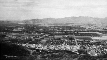
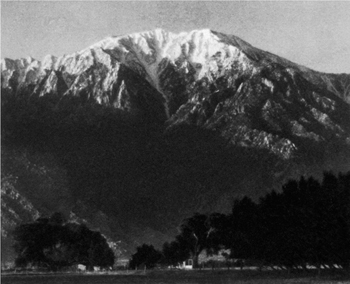
SAN FERNANDO VALLEY FROM MULHOLLAND DRIVE
F. W. Carter
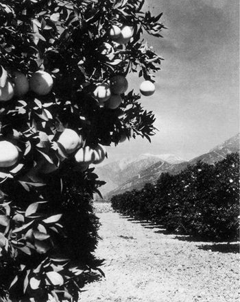
California Fruit Growers’ Exchange
GRAPEFRUIT GROVE
Theodore Baron
Horace Bristol
Burton O. Burt
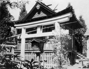
SHINTO TEMPLE IN JAPANESE FISHING VILLAGE, TERMINAL ISLAND
Burton O. Burt
Theodore Baron
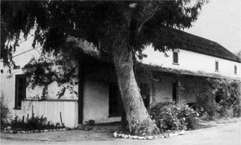
LASKY’S BARN, HOLLYWOOD
—FIRST HOME OF PARAMOUNT PICTURES
OLD LUGO HOUSE ON THE PLAZA, LOS ANGELES
Viroque Baker
Viroque Baker
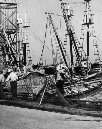
PORTUGUESE MENDING NETS, TERMINAL ISLAND
It is the administrative center for city government in the valley. Now a suburban area, it came into existence as a farm-trade center. The town was named for I. N. Van Nuys, an early settler.
The VALLEY MUNICIPAL BUILDING, NW. corner Sylvan St. and Sylmar Ave., houses branch offices and bureaus of the city government. Its eight-story central tower flanked by two-story wings—all of white stone and concrete structure, make it resemble the huge Los Angeles City Hall. It contains branches of all the usual municipal departments.
VICTORY-VAN OWEN PARK, between Whitsett Ave., Laurel Canyon Rd., and Calvert St., a 90-acre irregularly shaped tract, was acquired by the Los Angeles Park Department in 1929. It has picnic facilities for 200 persons.
SHERMAN OAKS, 15.5 m. (657 alt.), is a suburban real estate development.
ENCINO (Sp., oak), 18.3 m. (790 alt., 1,548 pop.), is a residential suburb in a beautiful area. Because of the numbers of great liveoak trees here in 1769 the Gaspar de Portola expedition named the valley Santa Catalina de Bononia de los Encinos (St. Catherine of Bononia of the Oaks). A number of Hollywood notables have built homes in the near-by Santa Monica foothills.
The AMESTOY ADOBE (private), 16801 Ventura Blvd. (R), was built in 1851 by Vicente de la Osa, owner of Rancho El Encino during the first two decades of the American regime. Its site was once considered by the Franciscan padres for San Fernando Mission. Containing nine rooms, the long, rectangular adobe, one room in width, faces a small lake, fed by water piped from natural springs south of Ventura Blvd.
The ADOHR MILK FARMS (open daily 1-5 ; large parties by special arrangement), 18000 Ventura Blvd. (L), spreads over 600 acres of valley and foothills at the western edge of Encino. It has a herd of 3,800, mostly Guernseys. The annual milk yield is more than 1,500,000 gallons. Adohr bulls and cows have been prize winners at agricultural fairs for a number of years. The establishment has barns, employees’ dormitories, garages, stables, warehouses, feed sheds, offices, and bottling plants. The administrative buildings stand among great oaks and sycamores along Ventura Blvd.
TARZANA, 20.4 m. (760 alt.), is a business and residential area surrounded by small farms used for alfalfa growing, truck gardening, and horticulture. The town was named for Edgar Rice Burroughs’ fictional character Tarzan, the author having bestowed that name on the estate of General Harrison Gray Otis, which he purchased in 1917.
Right from Tarzana on Reseda Blvd. to RESEDA PARK, 1.3 m. (R), a 42-acre forested area with an abundance of massive oak trees of great age. The city has planted additional trees, shrubs, and flowering plants. The park contains a pool and community clubhouse, and supervised playgrounds for children.
GIRARD, 24.4 m. (892 alt., 889 pop.), is a residential suburb of scattered Spanish and Moorish type homes.
Right from Girard on Topanga Canyon Blvd. to CANOGA PARK, 2.1 m. (790 alt., 2,460 pop.). Formerly known as Owensmouth, it was laid out in 1912 by H. J. Whitley. In the neighborhood are small farms growing walnuts, citrus fruits, berries, melons, field crops, sugar beets, and alfalfa.
CHATSWORTH, 6.2 m. (965 alt.), lies in a navel orange and fig-growing belt at the entrance to Santa Susana Pass. The name was suggested in 1898 by the Duke of Devonshire, who, during a visit to the valley, saw in this region a resemblance to Chatsworth Park, his ancestral home.
RANCHO SAN ANTONIO, 21004 Plummer St., is a home for underprivileged boys 11 to.15 years of age. Its long, one-story buildings of the ranch-house type are on a small farm that is worked by the 43 boys. The home is operated by the Catholic Big Brothers, Inc.
At 24.4 m. is the junction with Topanga Canyon Rd., now the main route; L. from US 101 on this road.
Right (straight ahead) on Ventura Blvd. to CALABASAS, 2 m. (929 alt.), a settlement consisting of a store, garage, cafe and a few scattered houses. The origin of the name is conjectural: according to one theory the Spanish named the spot Calabasas (pumpkins), because of the wild gourds, resembling pumpkins, that grew here; according to another the word is a corruption of Calahuasa, the name of a Chumash Indian village near Santa Ines Mission, in Santa Barbara County.
The trails of Spanish explorers crossed here several times: the Gaspar de Portola party, returning to San Diego from Monterey, traveled down Conejo Pass and passed this place on January 15, 1770; Juan Bautista de Anza (see Tour l), blazing an overland trail from Sonora to Monterey, traversed the region on April 10, 1774, and a year later his second expedition camped on February 22, 1776 on the banks of Las Virgines Creek. Following the establishment of San Fernando Mission in 1797 Calabasas became a way station for the padres in their journeys along El Camino Real to Ventura, Santa Barbara, and other northern missions. In the 1860’s it was a stop on the stagecoach line operated by Flint, Bixby and Company between Los Angeles and a junction of the Southern Pacific Railroad, which at that time had come no farther south than Soledad, in Monterey County. It was during this period that Calabasas developed its reputation as the “toughest” frontier town in southern California.
The L. J. Kramer general store (L), Ventura Blvd. and El Cajon Dr., is approximately on the SITE OF THE CALABASAS CORNER INN, the six-room plank structure that in the 1860’s and 1870’s witnessed most of the stage station’s lusty social life, since it was the store, town hall, dance hall, and saloon. Here, too, the Vigilantes met to decide the fate of captured bandits and cattle rustlers, many of whom were hanged on the massive live oak west of the store that is called the HANGMAN’S TREE. A noose dangling from the limb that extends over US 101 is merely a “prop.” The tree’s age is estimated at more than 500 years.
Along the east wall of the Kramer store is an oak post that reputedly marks THE SEALED WELL, the grave of three bandits. Following a gun battle of the 1870’s between bartenders of the Corner Inn, ranchers, and members of the Tiburcio Vasquez gang, the bodies of three desperadoes were thrown into the well here whose opening was sealed, according to popular legend.
The MIGUEL LEONIS ADOBE, 23537 Ventura Blvd., built in 1869 by Miguel Leonis, son-in-law of one of the first owners of the surrounding Spanish rancho, is now a roadside cafe. The two-story structure, with a wide two-story veranda along two sides stands in a semitropical garden with a grape arbor.
Among the first mission lands in San Fernando Valley allotted to private persons were the 1,100 acres in the west end granted to three Indians, Urbano, Odon, and Manuel, who called it El Escorpion Rancho (the scorpion ranch). In 1869 Leonis, a native of southern France, settled in the valley, became a sheepherder, and married a daughter of Urbano. Becoming manager of his father-in-law’s property, he soon owned the land and all its cattle, horses, and sheep, though as one historian describes him, he was “… a giant in stature and strength, a perfect savage in nature, besotted in ignorance, so illiterate that he could not read a word in any language.”
At 2.6 m., is the junction with a private road.
Right on this road 0.4 m. to the Los ANGELES PET CEMETERY (open 9-5; free), on rolling land at the foot of the Simi Hills. The cemetery, in use since 1928, is platted after the modern manner in burial grounds, with the graves marked only by tablets flush with the ground. Some 2,000 animals are buried in graves at the foot of the hill, about 50 more are in a mausoleum or in urns in the columbarium. Dogs predominate among the pets, but there are also cats, parrots, canaries, three monkeys, a horse and alligator, an owl, a duck, and a turtle. Interred here is Kabar, a dog that belonged to Rudolph Valentino and reputedly walked from New York City to Los Angeles after the death of his master; the story is that he died of a broken heart. Other residents are possums, a blue Maltese cat, a movie star which signed its own contract with a paw print; Bubbie and Tagalong, Louise Dresser’s dogs, and others that belonged to Winnie Lightner, Cesar Romero, Alice Brady, George Brent, Alice Joyce and other cinema luminaries. In adjoining graves lie Bill, a mallard duck, and Patsy, a Scotty. Bill and Patsy were pals who frequently walked, side by side, down Hollywood Boulevard. After Patsy died in 1937, Bill walked in front of an automobile and was killed.
At NEW CALABASAS, 3 m., are the Calabasas Post Office and Justice Court, a general store, a garage, and a few homes.
West of New Calabasas the highway enters CONEJO PASS (rabbit pass) which leads to the Ventura Coastal Plain. In the Simi Hills (R) SIMI PEAK (alt. 2,400) stands out boldly in the northwest; L. are the more abrupt folds of the Santa Monica foothills, with cattle grazing on their steep sides.
At 5.4 m. is the junction with Las Virgines Canyon Rd.
Left on Las Virgines Canyon Rd, 4.5 m. to TAPIA COUNTY PARK (picnicking facilities; baseball diamond), whose heavily wooded terrain is cut by Malibu Creek Canyon.
At 8.1 m. on.the main side road is AGOURA (1,000 alt.), which advertises itself as “The Picture City,” because of its popularity as a location. It was laid out in two tracts in 1928 by the L’Agoura family, Spanish grant owners. Part of the L’Agoura home ranch, with its old ranch house and auxiliary buildings, are now owned by William Randolph Hearst, the newspaper publisher. The charm of the place has caused many Hollywood writers, directors, actors, and artists to build homes here.
At 8.9 m., is the junction with Cornell Rd.
Left on Cornell Rd. into La Sierra Canyon,.2.3 m. to the PARAMOUNT PICTURES’ INC., LOCATION RANCH (adm. by pass only), which extends for more than a mile along a valley below the road. A variety of false-front, painted-canvas movie sets hug the low foothill knolls (R)—groups of log cabins, stockades and forts representing a frontier outpost, clusters of palm-thatched African huts, a street from a town of the Old West, the weathered stone walls and casement windows around a market square of an 18th-century French town, and middlewestern, European, early American, and cattle-ranch buildings.
At the foot of a sharp defile, at 2.8 m. where Media and Triunfo Creeks form Malibu Creek, the canyon floor becomes a wide valley holding MALIBU LAKE, an artificial body of water created in 1926 by the Malibu Lake Mountain Club. Scores of cabins belonging to club members line the five-mile lakeshore or cling to the steep, tree-clad slopes. The MALIBU LAKE MOUNTAIN CLUBHOUSE (private), on the west bank (R), is a one-story, white stucco structure, with wide French windows and terraces overlooking the lake. Many motion-picture scenes have been photographed on the lake and along its shores.
The road follows the lake to its western end, then swings R. to climb between abrupt slopes.
SEMINOLE HOT SPRINGS, 5.8 m., is a year-round health and pleasure resort, with springs, cottages, bathhouse, open-air mineral water plunge, and cafe buried in a copse of sycamores (R) below the level of the road.
At 12.8 m. is the junction with Protrero Rd.; L. from US 101 on this route.
The route bears sharply R. at 14.6 m., and moves through sloping meadows that merge with woods of widely-spaced live oaks. Since 1923 when the silent version of the motion picture Robin Hood, starring Douglas Fairbanks, Sr., was made here, this area has been known as Sherwood Forest, in memory of the Sherwood Forest of Nottinghamshire, England, celebrated in the Robin Hood legends.
Ascending gradually through the forest, the road tops a rise at 15.7 m. and then winds down along the northern shore of SHERWOOD LAKE (L), an irregular, privately owned, body of water formed by a dam at the eastern end. The area was developed as a summer resort, but in recent years about 250 people have established year-round homes here. Among the estate owners are Will H. Hays, censor and president of the Motion Picture Producers’ Association. Maria Jeritza, Winfield Sheehan, Jack Holt, Fredric March, Carleton F. Burke, Robert Stewart, and others.
From the Ventura Blvd.-Topanga Canyon Rd. junction, the main tour route ascends the north slope of the SANTA MONICA MOUNTAINS, rising from the valley level to the summit of the coastal watershed divide in less than three miles.
TOPANGA SUMMIT, 27.3 m. (1,560 alt.), at the head of Topanga Canyon, is on the divide between the coastal watershed and the San Fernando Valley. The view (use of telescopes on railing 10¢) encompasses the greater part of the valley—to the Santa Susana Mountains on the north, and the San Gabriel Range on the northeast.
From the summit the road descends Topanga Canyon in a long, gradual drop between steeply rising mountain ramparts. The canyon slices seaward through the range in a general southerly direction for nine miles. Scattered through it are the homes of some two or three thousand permanent and part-time residents. Bordering Topanga Creek in the lower part of the canyon are thickets of sycamores and alders, and, on the slopes, California holly.
From the sparsely forested uplands, the canyon gradually descends into heavily wooded areas as it approaches TOPANGA MINERAL SPRINGS (cabins at varying rates, free picnic grounds), 29.1 m. (L), distributing center for waters of a mineral spring.
TOPANGA POST OFFICE (L), 32.2 m. (750 alt.), about midway between the summit and the ocean, is a canyon trading center, with a post office, general store and garage.
CAMP WILDWOOD, 32.7 m., is another canyon trading center, supplying the needs of six to seven hundred cabin dwellers in near-by dells and side canyons; many are year-round residents.
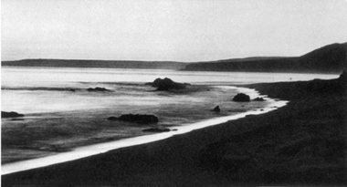
TOPANGA BEACH, 36.4 m., a shore colony at the mouth of Topanga Canyon, is part of the old Malibu Ranch. Residential sites are leased but never sold. Many of the houses were built by motion-picture people, but passed into other hands when the film colony moved to Malibu Beach.
At 36.4 m. is the junction with US 101A, now the main route; L. from Topanga Canyon Rd. on this road.
R. from Topanga Canyon Rd. on US 101A, Malibu Road, to LAS TUNAS BEACH (cactus beach), 0.4 m., a compact district of gay, brightly-tinted stucco houses between the highway and the mountains.
A row of less imposing frame cottages is on the other side of the highway.
LAS FLORES BEACH, 3.4 m., at the mouth of Las Flores Canyon, was part of Rancho Malibu, acquired from Mrs. Rindge for $6,000,000. The land was repossessed by Mrs. Rindge when the project’s developer was imprisoned for promotional peculation. The terms of the trusteeship under which the Rindge property now is being administered provide for the re-establishment of the subdivision.
Northwest of Las Flores Beach are the rolling hills and the miles of strand of RANCHO MALIBU, the lost empire of Mrs. May K. Rindge, a widow who resisted the penetration of public roads into her inherited ranch-barony for more than three decades with firearms, law books, and a large fortune.
High wire fences on both sides of the highway remain as reminders of the dispute. Sheets of cardboard attached to the fence posts carry an announcement that the United States Federal District Court in June 1938 approved removing Mrs. Rindge from control of the estate and placing it in receivership. She retains only a life interest in unfinished Rindge Castle and 60 acres surrounding it, and title to three beach properties and the family homestead in Marblehead, Massachusetts.
In 1804 parts of three Spanish grants, Topanga, Malibu, and Sequit, were awarded to Jose Tapia by Jose Arrillaga, military governor of the Californias; Tapia was a soldado de cuera (soldier of leather), one of the leather-jacketed men of the Spanish garrison at Santa Barbara—and the grant was a substitute for “back pay” owed by the Crown. The property passed through successive owners until 1892, when 16,000 acres were purchased by Frederick H. Rindge at $10 an acre. Rindge, of a wealthy Massachusetts manufacturing family, had come to California with his bride in that year and had envisioned a Riviera on this coast. By later purchases Rindge increased his holdings to 24,000 acres. During his lifetime, great herds of long-horns and bands of sheep roamed the hills and valleys. The undivided Malibu (Ind. deer) grant outlived all others of the Spanish-Mexican period and became known as the “last of the ranchos.” Rindge died in 1905 before his dream of a Riviera had materialized, leaving an estate valued at $54,000,000 to Mrs. Rindge and his three children. After her husband’s death the single passion of Mrs. Rindge, who became somewhat of a recluse, was to keep the great rancho intact. She spent a fortune in the attempt; she sued for libel, trespass, and defamation of character to oust squatters, and to close public roads : she continually sought injunctions to prevent road-building. One trial lasted 120 days; another series of lawsuits lasted 10 years. She in turn was sued by others, once by her own son, Samuel Rindge, who charged she was dissipating the estate at the rate of more than $1,000,000 a year. In the course of her fight on a county-built road (1918-19), Mrs. Rindge sent droves of hogs onto it, and once ordered the roadbed plowed under and planted with alfalfa. In 1925 state employees who were surveying the new right-of-way were driven off by armed guards. Construction could proceed only after court injunctions were obtained against her. In 1925 the Superior Court handed down a decision granting the state authority to construct what is now US 101A through the property. A decade later Mrs. Rindge played an entirely different role in court: unsecured creditors filed a petition in bankruptcy against the Marble-head Land Company—the name that Rindge had applied to his venture. Faced with some $10,000,000 in obligations, Mrs. Rindge countered with a voluntary petition for reorganization. In 1938 the Federal District Court ordered the reorganization, and Mrs. Rindge now lives in her West Adams Boulevard home in Los Angeles.
US 101A spans MALIBU LAGOON, 5.9 m., a multitentacled arm of the sea running a short distance inland. On the spray-washed rocks at the lagoon entrance (L) seals sun themselves.
Crowning a truncated promontory (R), about one mile inland, is the 45-room RINDGE CASTLE (private), the uncompleted stronghold built by Mrs. Rindge. Constructed of reinforced concrete and designed in the Spanish-Mediterranean style, the mansion was never occupied. Mrs. Rindge, more than 60 when she began building the castle, could not complete construction because she ran out of cash.
It has been estimated a quarter of a million dollars would be needed to complete it as designed.
Northwest of Malibu Lagoon US 101A, turning slightly inland, forms the northern border of MALIBU BEACH COLONY, 6.1 m. which occupies a sand-spit extending to the sea. It consists of a mile of beach houses belonging to film celebrities, artists, writers, and musicians. The community (unincorporated) is closed to the public. A wire fence, frequent “Private Property” signs, and chains across the motor approach, policed by the uniformed Malibu Seashore Patrol guard the privacy of those who can afford to buy their way into this area of the elect.
From the Malibu Rd.-Topanga Canyon Rd. junction, the main tour route goes southeast (L) on US 101A, between the sea and the precipitously rising mountain scarp.
CASTELLAMMARE, 37.6 m., is a seaside area with a private beach (R) and a residential section (L) on terraces carved from the mountain, which here drops sharply to the highway’s edge. The terraced slopes have stone revetments and are planted with Lipia grass.
At 38 m. is the junction with Sunset Blvd.
Left on Sunset Blvd. to the BERNHEIMER ORIENTAL GARDENS, 0.8 m., (open 8-6; adults 10¢, children free; Bernheimer home open on irregular days, adm. 52¢), an eight-acre estate on the edge of the Pacific Palisades, overlooking the sea, scientifically landscaped and beautified in the Oriental manner. From an Oriental gatehouse (R), a palm-lined private road leads to a hill crowned by a group of small one-room Japanese houses—the home of Adolp Bernheimer, cotton exporter and designer of the gardens, who in 50 years made 17 trips to the Orient collecting the treasures in the house and gardens.
To the left of the gatehouse is a reproduction of the stables in the temple grounds at Nikko, Japan, in the black, mauve, and gold colors characterizing all the buildings. Beside the stables is a rock-lined lily pool with a bronze miniature of Lao-tse, Chinese philosopher of the sixth century B.C., mounted on a horse.
The exceptionally life-like bronze figure of Ten-Jin, ninth-century Japanese religious teacher, mounted on a representation of a sacred ox, watches over the entrance to the flower and bronze-lined path which winds to the Bernheimer home. Each room of the home is a separate house, although the four units are connected by pergolas. Treasures include color paintings on rice paper many hundreds of years old, bridal and temple kimonos, fingernail tapestries—woven by specially-grown fingernails; and two pairs of devil-dogs—traditional protectors from evil spirits, the bitch of each pair represented with suckling pups.
More bronzes enhance the downward path to the Sunken Garden, among them a Burmese Buddha in a “wishing well.” At the bottom is a miniature lake, replete with miniature temples and figures of warriors and elephants.
Bernheimer, a native of New York, began collecting Oriental objects in 1887, came to Los Angeles in 1913, and in 1915 created an Oriental garden on a hilltop near Hollywood Blvd. and Franklin Ave. (see Hollywood). Work was begun on the present location in 1925 and completed in 1927. Total expenditures came to $3,000,000.
The CALIFORNIA STATE BEACH (free), 40.2 m., extending (R) between W. Channel Rd. and Mayberry Ave., at the northern edge of Santa Monica is only one of several state-owned beach lands lying between Santa Monica and Malibu Beach.
Southeast of the state beach, US 101A skirts the edge of the Santa Monica Palisades (L) and a half-mile-long row of beach homes (R), many of which are the seaside residences of film celebrities.
SANTA MONICA, 42.1 m. (100 alt., 53,500 pop.) (see Santa Monica).
Points of Interest: Clover Field, Douglas Aircraft plant, Yacht Harbor, Palisades Park, Municipal Aquarium, Municipal Pier, and others.
At 45.4 m. is the junction with Washington Blvd. (see Tour 5).