Once famed as the Spice Islands, the Moluccas (now known as Maluku) were zealously sought for many years before Portuguese mariners finally located them in the 1500s. Explorers like Christopher Columbus, Vasco da Gama, Ferdinand Magellan and Sir Francis Drake all dreamed of finding their wealth there. In fact, one of the main incentives for Europe’s Age of Discovery was the avid search for spices, easily worth their weight in gold at that time. Cloves, nutmeg and mace were used to camouflage the taste of spoiled meat in the days before refrigeration, and for medicine.
While its current production of nutmeg and mace is negligible, for centuries the tiny Banda islands supplied every last ounce of both, their origin a well-kept secret by Arab traders in Venetian markets prior to the arrival of the Portuguese. Control of the spice-producing islands assured vast fortunes, and countless lives were lost in the quest for them. But the introduction of refrigeration and British success in propagating nutmegs and cloves in Sri Lanka was to end the spice wars forever.
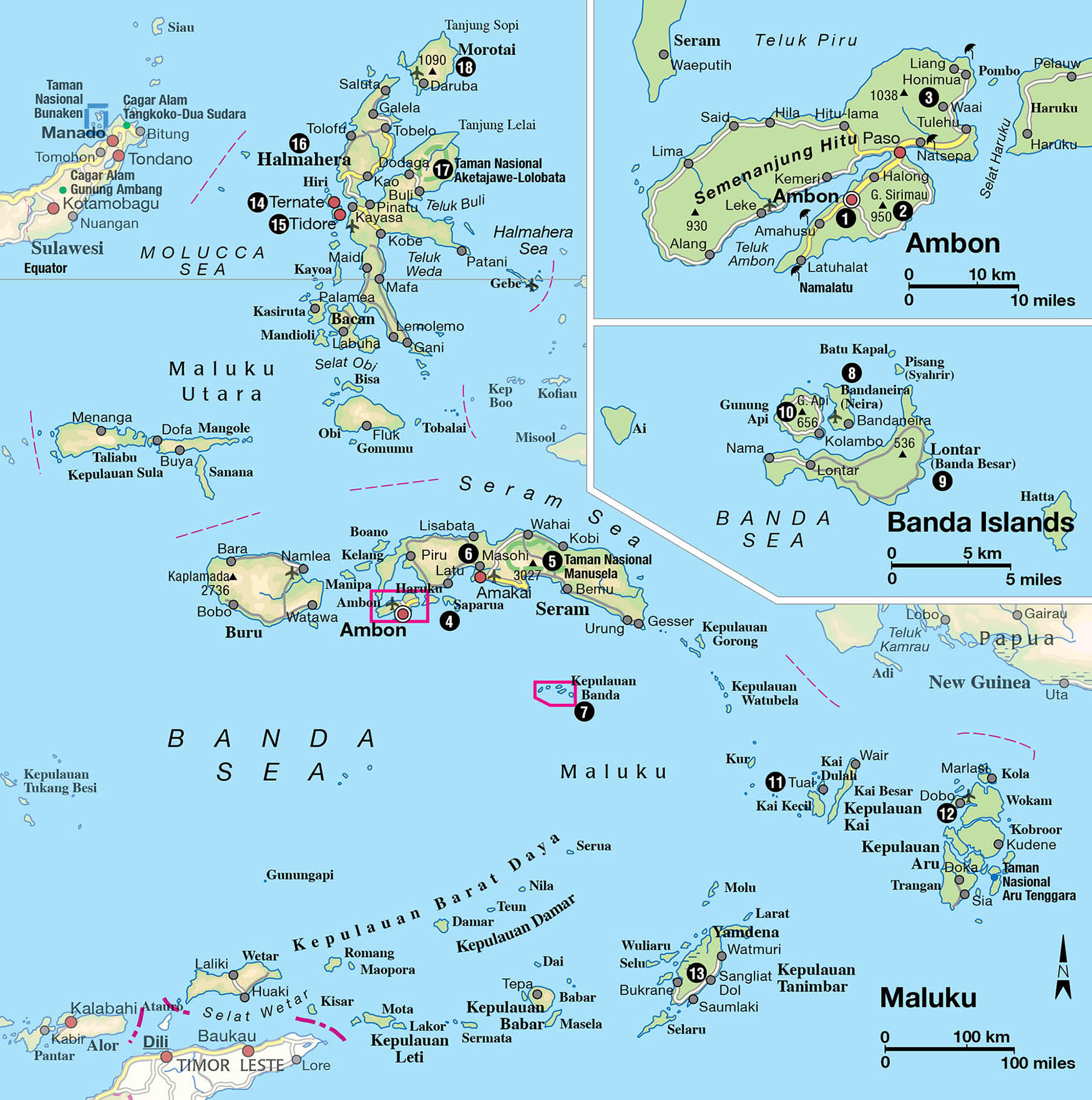
Scattered across the sea north of Timor and east of Sulawesi like a double-handful of dropped pearls, part of Maluku extends to the Arafura Sea south of Papua. Due to remoteness, Maluku’s two national parks bring in few visitors, but its spice trade-era and World War II historic sites are of interest to history buffs. It is the sensational diving, however, that lures most visitors. With so much sea, virtually every type of marine topography are can be found here.

A marbled cat.
Alamy
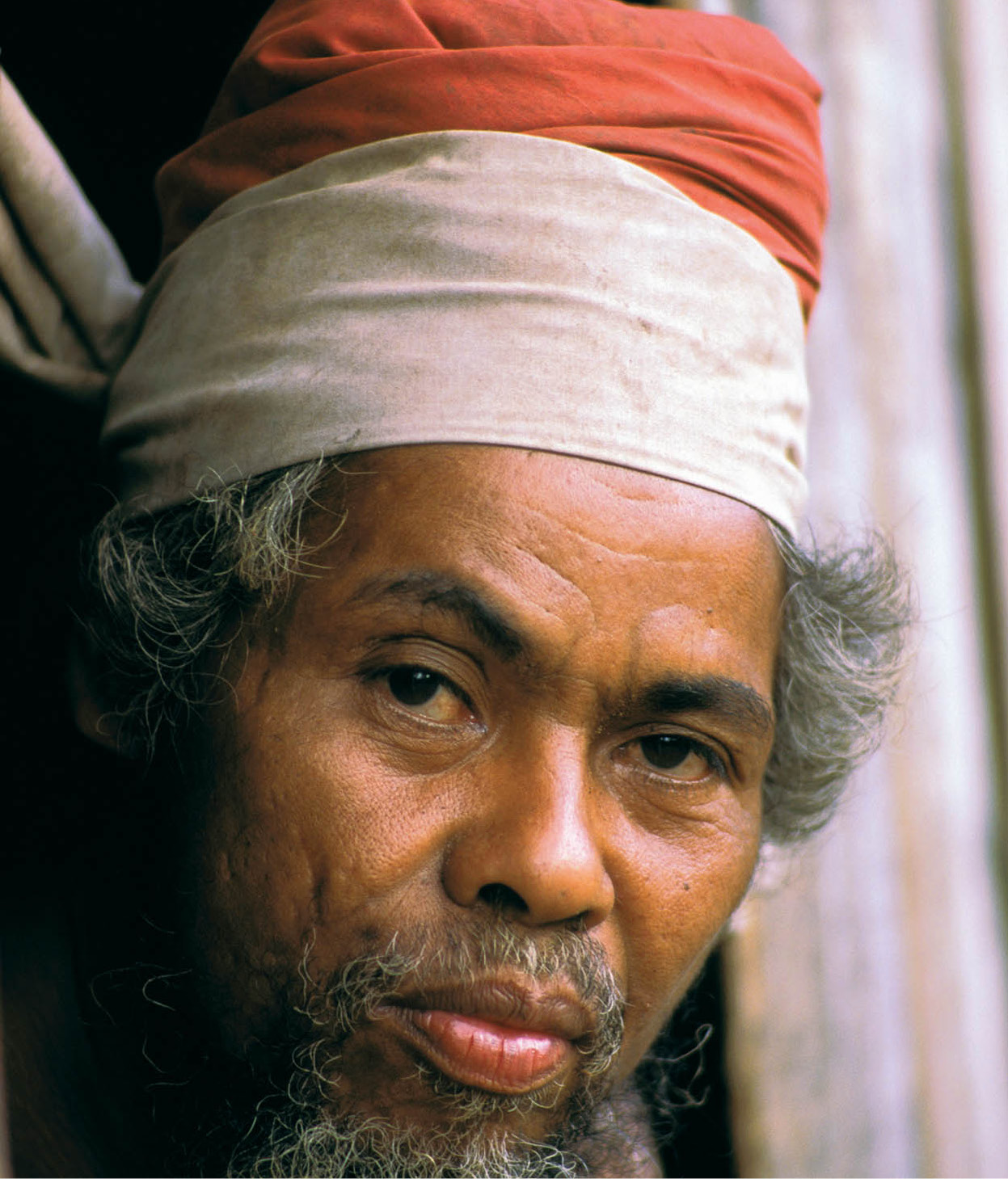
A Naulu man on the island of Seram.
AWL Image
Flora and fauna
With eastern Maluku in the Wallacea transition zone, there are only a dozen or so species of land mammals. Indigenous marsupials include the squirrel-like gliding possum, three kinds of prehensile-tailed cuscus, a tree-climbing kangaroo and the wallaby. There are also over 25 species of bats.
Birdlife, however, is prolific. The 300-odd species of birds include over 40 different kinds of birds of paradise, which are concentrated in the Aru archipelago; a couple of dozen species of parrot, headed by the large, handsome red-crested palm cockatoo; beautiful crimson lories; and strange mound-building megapods. These can be seen in Maluku’s two national parks.
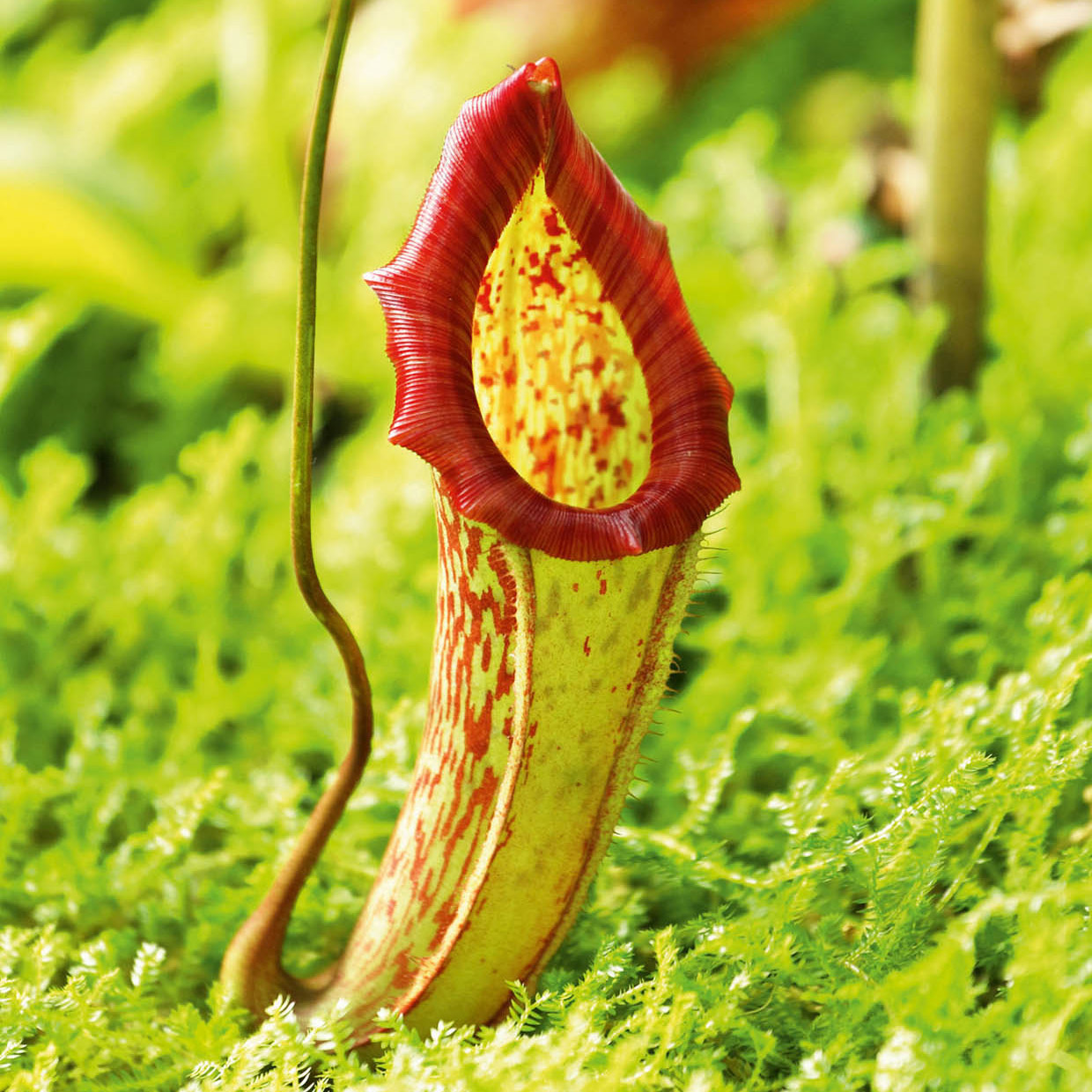
A pitcher plant.
Fotolia
Fact
The clove is not a seed or fruit, but the unopened flower bud of the clove tree. A single tree will yield about 2kg (4lbs) of cloves, best picked between the months of August and September.
Ambon
Ambon 1 [map] is the metropolitan focus of Maluku. By the 19th century, due to Dutch influence, about half of Ambon’s population had converted to Christianity. The newly baptised Ambonese availed themselves of educational opportunities, forming the backbone of the Dutch colonial army. Not even World War II could shake their loyalty to Holland. Maluku was overrun by superior Japanese forces in spite of heroic Australian resistance in Ambon, and the area became a central Japanese base. After the war, the Dutch returned to a rousing welcome in Ambon. When Indonesia became independent later, Ambon resisted; thousands fled to Holland while others fought a guerrilla war against the Indonesian military.
Ambon city’s architecture, functional but nondescript due to bombing in 1944, was almost entirely destroyed during the 1999–2000 upheaval. Fortunately, the entrance to the 18th-century Benteng Victoria, Ambon’s most worthwhile colonial relic, remains. However, it is difficult to find, and it is forbidden to take photographs unless one has a permit from military security in Jakarta. At the end of Ambon’s main street, Jalan Patty, is Mesjid Al Fatah, the main mosque next to the handsome old Mesjid Jame.
Nutmeg was once worth a fortune.
Sylvaine Poitau/Apa Publications
Banda and the nutmeg saga
At the heart of wars between European nations and Indonesia from the 14th to the 17th century was a small egg-shaped seed from the nutmeg tree (Myristica sp.) and the colourful orange-red membrane surrounding it called mace. For many centuries these treasures only grew on Run island in the Banda archipelago and were sold by Arab traders in Venice for a profit of as much as 2,500 percent.
By the time the first Europeans – the Portuguese – arrived in the 16th century, unlike its neighbouring Islamic sultanates, Banda was organised into several democratic republics. Not only did the Bandanese take great pride in their active role in the shipping of their own goods between Maluku and Java, they had a thriving entrepôt trade in equally precious cloves.
Whereas the sultans of Tidor and Ternate made deals with Portuguese (and later the Dutch and the English) in return for increased power over all of Maluku, the Bandanese remained independent until the VOC arrived. With the consent of the Tidor and Ternate sultans, the VOC drove the Bandanese into slavery, destroyed their plantations and massacred as many as 15,000 inhabitants in 1621 for refusing Dutch control. The VOC eventually resettled the Banda islands with imported labourers.
The Museum Siwalima is located on a hill just beyond the urban area. Off the paved road on the way up, see the impressive Japanese shore battery, still protected by its concrete bunker. The museum displays aspects of Maluku’s natural history and geology, but the emphasis is on ethnography, with many fine objects, including ancestral carvings from the southern islands. Unlike many museums in Indonesia, most of the interesting showcases have an English description. The summit of Gunung Nona has the best view of the bay and Ambon town. Ambon Bay hosts some intriguing dive sites in The Twilight Zone, with strange-looking creatures inhabiting slopes beneath the traditional fishing fleet; there’s also a Dutch shipwreck.
Fact
In 1621, troops under the VOC governor-general Jan Pieterszoon Coen massacred nearly every Bandanese male over 15 years of age. Banda’s leaders were decapitated at Benteng Nassau, with their heads placed on spikes as an example to those opposing Dutch rule.
On the outskirts of town, in the opposite direction from the museum, the large, well-trimmed Australian War Cemetery holds the remains of Australian and other Allied troops who died during World War II. Lovingly maintained by the Australian government, many of those buried here were prisoners of war who perished in spite of the heroic aid given to them by the Ambonese.
Beyond the city
Soya Atas village is less than halfway up the slopes of 950-metre (3,100ft) high Gunung Sirimau 2 [map]. There is a fine church there, but be sure also to check out the baileo – a ritual meeting place with sacred megaliths. From Soya Atas, a path leads up to a sacred hilltop site with more megaliths and a water container that never dries out. Drinking this water is said to bring health, love and prosperity. Footpaths from Soya Atas descend to some of Ambon’s most traditional villages. A guide is recommended. Beware of the local Luhu ghost in the area, the beautiful daughter of a former raja with a predilection for handsome foreign men.
A couple of popular beaches lie to the west of town. Amahusu is 7km (4 miles) away on the bay side, while Namalatu, 16km (10 miles) out, faces the island’s southwestern shore. In the other direction, east of Ambon, the beach at Natsepa offers protected, shallow water. Beyond Natsepa, the road leads to Tulehu village and on to Waai 3 [map], which has sacred eels living in a spring-fed cave whose waters flow into a crystal-clear pool. Their keeper entices the eels to slither out of the cave by flicking his fingers on the water’s surface, then cracking open raw eggs. Near Honimua village at Liang, there is a long, deserted beach and a pier from which dolphins and skipjacks can be spotted. The best swimming and snorkelling is off Pombo island, accessible by boat from either Tulehu or Honimua.
Rounding the bay out of Ambon city, a paved road cuts across Hitu to the island’s north coast. On this road are clove plantations, occasional stands of mace and nutmeg and – with luck – you can see villagers processing sago tree trunks into a starchy paste, the staple diet for many people. On the north coast, the road swings to the west. At Hila village is Immanuel Church and the Mesjid Wapauwe, whose foundations were laid in 1414. A short stroll away are the seaside ruins of the majestic but neglected Benteng Amsterdam.
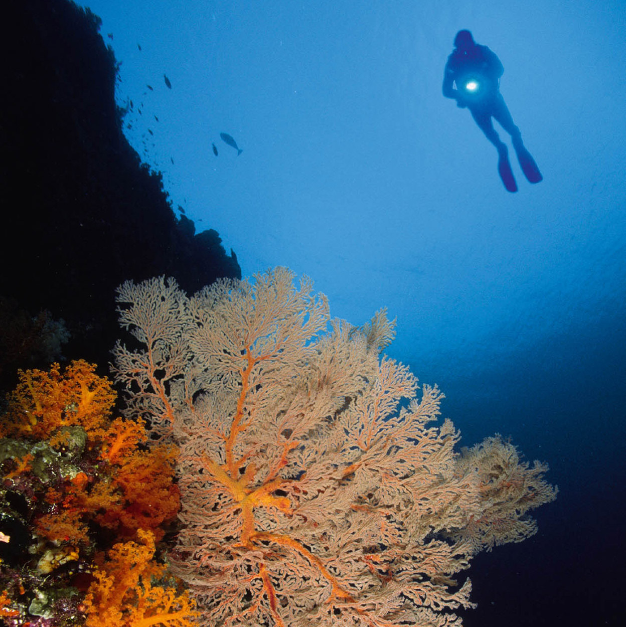
Ambon’s diving is diverse and exciting. In 2008 Maluku Divers discovered a new species of frogfish, Histiophryne psychedelica, found only on the slopes of The Twilight Zone. This discovery has generated huge international interest in the destination, which is now extremely popular for underwater photographers. Regular trips set off in search of vibrant fish life and explorations of dramatic underwater topography on the southern and eastern coasts as well. There are several sites off Seram island, too, and the fish-smothered slopes around nearby Pulau Tiga.
Among the islands near Ambon, Saparua 4 [map], a 2-hour ferry ride from Tulehu, offers several interesting attractions. Ouw village produces pottery – simple, elegant and functional – for practical use and for sale in Ambon. Dominating a turquoise bay, Benteng Duurstede has been restored and bristles with cannons.
Fact
National hero Thomas Matulessy, known as Pattimura, was a native of Saparua island. He fought Dutch oppression but was defeated in Saparua, and subsequently hanged in Ambon in 1817.
Manusela National Park
Seram, the largest and among the least-known islands in Maluku, hovers over Ambon, Saparua and Molana. Seram lies within the Wallacea Transitional Zone and is a key area for global studies on species evolution. The central Manusela National Park 5 [map], which is home to 2,000 species of butterflies and moths and 120 species of birds, covers an area of 189,000 hectares (467,103 acres). Wahai village is the northern entrance to the park, and Sanulo village, overlooking the Bay of Teluti, is the southern gateway.
Many of Ambon’s traditions are said to have originated in Seram, including the division into two sets of customs, the patasiwa and the patalima, as well as the pela alliances between two villages, often located far apart. Seram is also steeped in magic, for the Ambonese anyway, with many anecdotes of men who can fly and change their shape at will. While the western part of the island has lost its mystery, thanks to a thriving lumber industry, the remote eastern mountains are where the magic is concentrated. Gesser, on the eastern tip of Seram, has the exotic Bati hill tribe, known to have exceptional supernatural powers. They remain secluded from civilisation by choice.
Another group of mountain people, the Naulu, live close to Masohi 6 [map]. Of the few remaining tribes in Maluku who closely adhere to ancient traditions without the veneer of a foreign religion, the Naulu are the easiest to reach. The men’s distinctive red headbands, worn after initiation rituals, distinguish the Naulu from their Malukan neighbours. The initiation requires a 5-day trek in the mountains of their ancestral homeland, where they must kill a deer and a boar with a spear and a tree-dwelling cuscus with a single arrow. Explorations further into Naulu lands require hiking (with a guide) inland to the mountainous Manusela National Park.
Tip
To catch the sunrise atop Gunung Api at Banda, and the breathtaking views before early-morning cloud cover forms, start your ascent at 5.30am. The climb should take 1.5 hours, but check on conditions first, as the volcano last erupted in 1988.
Banda
South of Seram and Ambon is Kepulauan Banda 7 [map], or the Banda archipelago. ‘Founded’ by the Portuguese in 1512, it was the Dutch who arrived a century later to set up a spice monopoly. The English, who came later, undercut the Dutch efforts of price control by shipping nutmeg and mace to Europe from Run island, in the Bandas. The Dutch monopoly was restored when Manhattan was traded for Run, but as spices were increasingly produced elsewhere, the nine Banda islands faded into obscurity.
The Bandas’ importance in the English–Dutch struggle to control the spice trade is evidenced in its remaining forts. A military headquarters until 1860, Benteng Belgica was restored in the early 20th century and dominates Bandaneira 8 [map], the major island of the archipelago. Closer to the sea, Benteng Nassau, important during VOC governor-general Jan Pieterszoon Coen’s efforts to control Banda in 1621, crumbles in neglect. The string of forts continues on neighbouring Banda Besar 9 [map] island with Benteng Concordia and Benteng Hollandia, built by Coen high on a ridge to command the surrounding seas, and destroyed by earthquake in 1743. Benteng Revingil (Revenge) rises from the ocean on Ai island. On both islands, old nutmeg smokehouses line trails through fragrant nutmeg groves, dotted with huge mango and kanari (tropical almond) trees, coffee and other exotic plants as tropical birds fly overhead.
Energetic souls may want to climb Gunung Api ) [map], an active volcano directly opposite Bandaneira. It last erupted in 1988, but fortunately almost all of the lava and ash fell on the side away from the town. The view from the summit is spectacular. Attempt this with a guide and get an early start to beat the heat of the day. In Bandaneira, the Museum Rumah Budaya holds many historical artefacts. Other sites include a church dating from 1852, its interior stone slab graves inscribed with the names of Dutch colonialists, and the Mesjid Hatta-Syahrir. The Istana Mini, the old governor’s mansion, has the former resident’s suicide note carved on one of the window panes. Next door is the former VOC headquarters, which has a statue of King Willem III, the great-grandfather of the present Dutch queen. The Museum Muhammad Hatta and the Museum Sjahrir contain memorabilia of Indonesia’s top nationalist leaders who were exiled in Bandaneira in the mid-1930s. The Museum Captain Cole was named after the British leader who captured Banda from the Dutch in 1811.
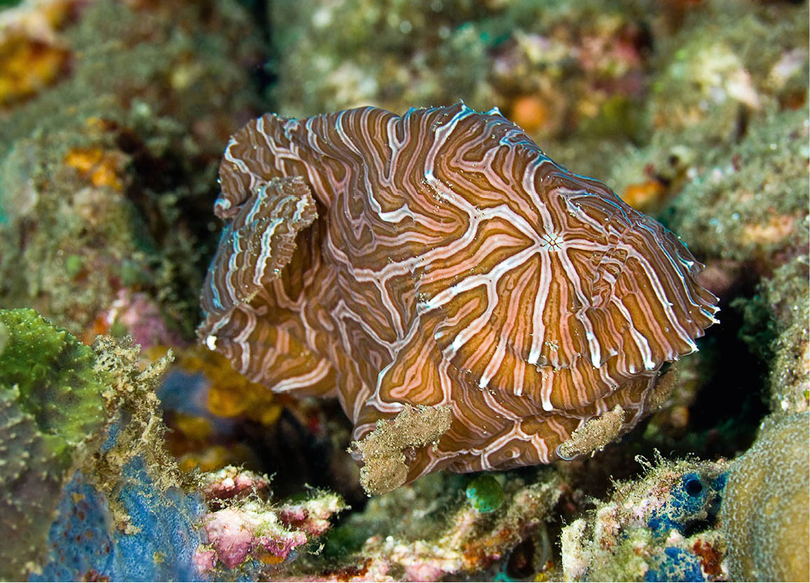
A coral reef off Banda.
iStock
Banda’s islands, like the majority of Maluku’s fertile waters, offer excellent diving opportunities. Snorkelling is also possible on sites within Banda’s huge natural harbour. One special site, Lava Flow, situated upon the lava from Gunung Api’s 1988 eruption, has been identified as having the world’s fastest-growing table corals, with layer upon layer reaching a span of 3 or 4 metres (10–13ft). Sharks and pelagic species patrol deeper waters, while a myriad of colourful fish swarm coral-encrusted walls. Banda has a unique mandarin fish; every evening divers can observe and photograph its mating ritual. In April and October, the seas are calm and visibility excellent. The Bandas also have seasonal fishing, primarily for tuna, marlin and snapper.
Beyond Banda
East and southeast from the Banda islands, travel becomes more difficult. Yet both Tual in the Kepulauan Kai archipelago as well as Saumlaki in the Kepulauan Tanimbar offer attractions. The airstrip near Tual was built by the Japanese during World War II. Nearby, in the grounds of the Roman Catholic mission, a relief sculpture depicts the history of Catholicism in the area, starting with the arrival of Jesuits in the late 19th century. During the war, the Japanese invaded the Kai islands, murdering the bishop and 13 foreign priests.
Tual ! [map] on Dullah island is the capital of the Maluku Tenggara (Southeast Maluku) district and the transportation hub for an extensive network of roads and sea lanes. A half-hour ride away is Dullah village, where the Museum Belawang displays a splendid ceremonial canoe, complete with carved decorations. Close to Tual is Pasir Panjang, a powder-white beach that stretches for 3km (2 miles). From Tual, motorised canoes depart for the mountainous Kai Besar island. Occasional boats from Tual also head for Dobo @ [map], Maluku’s pearl capital and the largest town of the Kepulauan Aru archipelago. Comprising 25 islands, the coastlines of the Aru islands are mangrove swamps, housing an abundance of pearl oysters, shrimp, lobsters and other fish. Its low-lying palm forest holds unusual butterflies, flocks of several species of birds of paradise and wallabies. Aru is also significant as a turtle nesting ground. Rare dugongs are still easily spotted in the seagrass beds found throughout Aru.
Banda’s underwater life.
Alamy
Kepulauan Tanimbar
South of the Kai islands is the Kepulauan Tanimbar group of islands. This area only went under Dutch control in the first years of the 19th century, during the final phase of Holland’s colonial expansion in Indonesia. Saumlaki on Yamdena island was a Japanese air base during World War II. Tanimbar artists carve strange statues of humans with big heads.
At Sangliat Dol £ [map], on northeast Yamdena, there is a megalithic staircase that leads to the village ceremonial ground featuring a huge stone boat with a carved prow. The local people believe that their ancestors arrived in this sacred craft. Near Saumlaki is an island known for its rare species of orchids.
Ternate and Tidore
North of Ambon, the administrative and geographical district of the northern third of Maluku is dominated on maps by Halmahera, but tiny Ternate $ [map] island is the real centre of power and communications as it is the capital of North Maluku province. Two-thirds of the island’s people live in Ternate town, the business and market centre of the region.
One of the major clove-producing islands of Maluku, Ternate had been trading with Chinese, Arab and Javanese merchants hundreds of years before the first European arrival. The Portuguese were there in the early 1500s, followed by the Dutch at the start of the 17th century. Benteng Oranje was built by the Dutch in 1667 and is currently used by the Indonesian police and military. There are many ancient cannons in the large complex. On the outskirts of town, towards the airport, there is a mosque whose foundations date back to the 15th century. Its multi-tiered roof covers an airy space, beautifully designed for prayer and meditation.
A bit further out on the road to the airport, the Kedaton, or Sultan’s Palace, built in 1796, houses a museum. Prior arrangements can be made through the local tourism office to see the museum’s jewel, the magical crown reputed to be a personal gift from Allah to the first sultan who submitted to Islam. Some hair attached to the crown is said to be growing, requiring periodic trimming. A few years ago, when Gunung Gamalama threatened to erupt, the son of the last officially recognised sultan took the crown on a boat ride around Ternate to calm the impending eruption. It worked. Three times a week the crown and the resident spirits receive offerings of flowers, holy water and betel nuts.
A 45km (30-mile) paved road encircles Ternate, never wandering far from the coastline and the volcanic slopes of the 1,720-metre (5,640ft) Gunung Gamalama. At Dufa-Dufa village, the Portuguese Benteng Toloko fort stands on a seaside cliff, in surprisingly good shape and with a still-legible seal on its main entrance. Batu Angus (Burnt Rock) is a former lava flow, now jagged rock, which continues underwater for quite a distance. On the northeast coast, the steep slopes of Hiri island pop into view. Nearby, there are two crater lakes, both called Danau Tolire.
After rounding the north of Ternate, the crumbling Portuguese Benteng Kastella fort comes into view. From here, there is a path to the sacred Akerica royal springs and to the huge old Afo clove tree. Past Kastella and just before Ngade village is Danau Laguna. This lake, partially covered with lotus plants, is home to sacred crocodiles who, it is believed, trace their ancestry to a princess. Seeing one of them is said to lead to a lifetime of good luck. A path along one side of the lake rises to give a splendid view of Danau Laguna, with Maitara and Tidore islands in the background. The last stop, Benteng Kayu Merah fort, offers a sea-level view of the same islands.
Tidore % [map] island, a bit larger than Ternate, is for the less energetic, belying its history as a former rival of Ternate’s clove production in the 17th century. Frequent boats leave Bastion for Run, where there is a weekly market. Tidore is dominated by the volcano Gunung Kiematubu. A paved road encompasses most of the island, but beyond the main town of Soa Siu, the surface degenerates considerably.
Halmahera and Morotai
At one time governed by the sultanates of Tidore and Ternate, Halmahera’s ^ [map] main town is Tobelo, which lies on the eastern shore of the island’s northern peninsula. Daru village is south of Tobelo, while further south near the bottom of the bay is Kao, which hosted some 80,000 Japanese troops during World War II, earning itself the name of Little Tokyo. Prior to landing on Morotai further north, Allied planes bombed the installations here. A few anti-aircraft guns still guard the landing strip, which was built by the Japanese. There are several bunkers near the runway. Offshore, superstructures of Japanese shipwrecks protrude above the surface of the water.
Where
Some 2km (1.2 miles) northeast of central Ambon in Karang Panjang is the statue of Martha Tiahahu, a local heroine who took up arms against the Dutch when her father was captured by the colonial forces. When caught and exiled to Java on a ship in 1818, she starved herself to death.
On the northeastern peninsula of Halmahera is Aketajawa-Lolobata National Park & [map], a small (1,673-sq km/646-sq mile) conservation area by Indonesian standards. Out of 51 mammal species found in North Maluku, seven are endemic to Halmahera island. Equally important are the 211 bird species found in the park, of which 24 are endemic.
Morotai island * [map] was the site of a major battle during World War II. The task force led by General Douglas MacArthur swept ashore after destroying the light Japanese defence there, as well as the concentration of power at Kao Bay. Morotai was vital to MacArthur’s island-hopping strategy towards the Philippines and onwards to Japan. Although many of the relics from the war were carted off to a steel mill in Java, there are still remnants of war machinery. In 1973, a Japanese soldier came out of the jungle, nearly three decades after Japan surrendered. And it is rumoured that there may still be Japanese survivors on the island.