DAVIS COUNTY
7
Adams Canyon
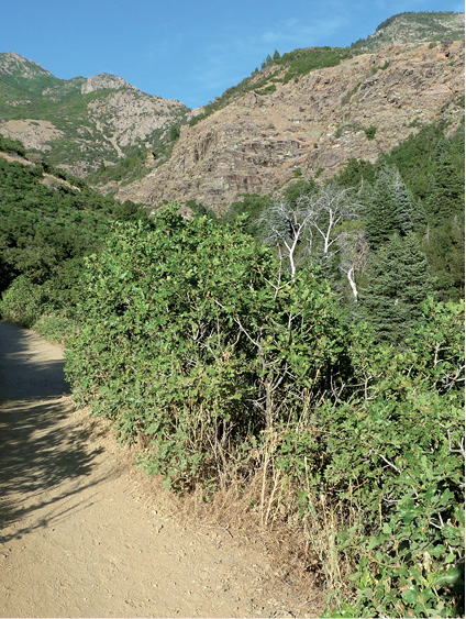
It’s safe to say that Adams Canyon is Davis County’s most popular trail due to accessibility and the 40-foot waterfall at the end of the canyon. Adams Canyon was named for Elias Adams, an early pioneer, but today the trail is much more developed than it was in his day. The hike begins on a sandy, sun-exposed climb where barriers have been built to keep the trail from dissolving down the hillside. Once in the canyon, the trail is shaded and runs next to the north fork of Holmes Creek. You enjoy the sights, sounds, and coolness of the stream as you climb your way to the fresh and impressive waterfall at the top.
Start: Northeast corner of the parking lot
Distance: 4.0 miles out and back
Hiking time: About 2 hours
Difficulty: Moderate
Elevation gain: 1,247 feet
Trail surface: Dirt, stone, some rock scrambling, stream crossing
Best season: Summer and fall
Other trail users: None
Canine compatibility: Dogs permitted
Land status: Uinta-Wasatch-Cache National Forest
Nearest town: Layton
Fees and permits: No fees or permits required
Maps: USGS Kaysville
Trail contacts: Salt Lake Ranger District, 6944 South 3000 East, Salt Lake City 84121; (801) 236-3400
Special considerations: In places the trail requires scrambling across rock faces and steep root inclines and may not be suitable for the less than fit. Watch for rattlesnakes.
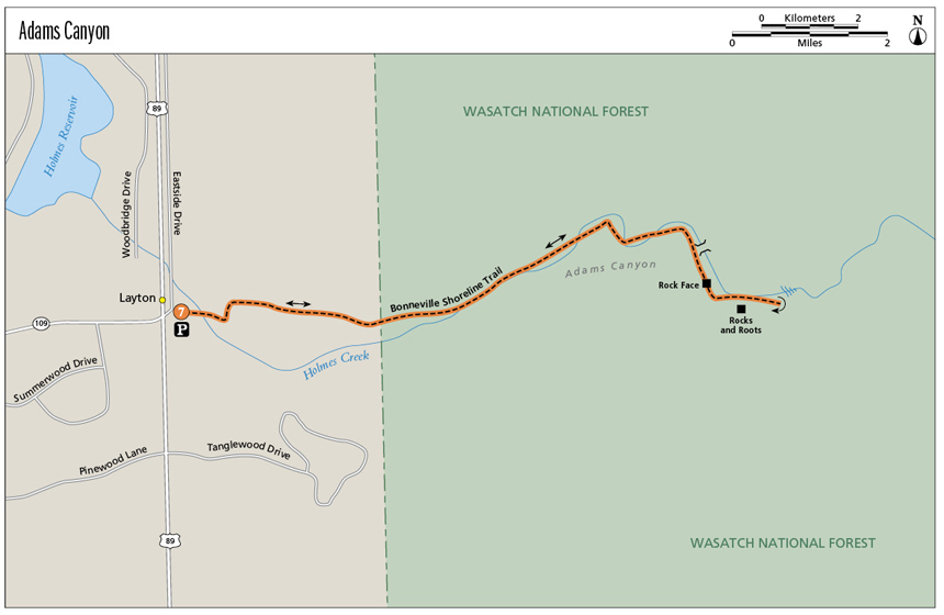
Finding the trailhead: From Salt Lake City head north on I-15 to exit 324 near the Lagoon Amusement Park. Head south on US 89 toward South Ogden for 6 miles. Take your first right on a small road after the Oak Hills Drive stoplight and then another quick right onto a frontage road. The trailhead is 0.25 mile down this road. Parking is plentiful, but no water or restrooms are available at the trailhead. GPS: N41 03.980' / W111 54.565'
The Hike
Once within the canyon itself, the hike provides shade and pleasant traveling, but the first 0.5 mile—from the trailhead up to the Bonneville Shoreline Trail—is a sandy slog that climbs over 500 feet of switchbacks to line you up for entry into the canyon. At the top of this section you hit the Bonneville Shoreline Trail (BST), a trail that marks the old shoreline of prehistoric Lake Bonneville. From the BST you gain a viewpoint out across the valley below. Views open up of Antelope Island, the Oquirrh Mountains on the west side of the valley, and the Wasatch Front.
Head right along the BST and continue straight into the canyon when the trail continues to the south. The trail then winds into Adams Canyon and drops into a shaded singletrack that follows the north fork of Holmes Creek through scrub oak and white pine. The well-defined trail is easy to follow, with the first creek crossing coming 1.5 miles into the hike. A new bridge makes crossing easy, but once on the other side you quickly enter the last phase of the hike and the most difficult maneuvering over rock faces and a less-defined trail. Stick closer to the creek when you have the option rather than getting caught up in the talus and side trails up the right side of the mountain.
There are places along this last portion of the trail where you may wonder if you have hit the end of the trail, but keep going. You’ll know the end—the waterfall is hard to miss. The trail and the creek curve to the left just before the waterfall, and here you must cross the stream. Plan to get your feet a little wet, as the crossing is shallow but 20 feet wide. Once you cross the creek and turn the corner, the waterfall appears out of nowhere. This is a perfect spot for a snack or lunch and a dip in the falls before heading back to the trailhead.
Miles and Directions
0.0Start at Adams Canyon trailhead.
0.5Hit the Bonneville Shoreline Trail; head right and continue straight into the canyon.
1.6Come to a bridge crossing.
1.7Reach a rock face that requires scrambling over or hiking up and over the top of the rock.
1.8Come to a jumble of rocks and roots that must be scrambled up and over.
1.9The trail appears to run into a talus slope. Follow the trail along the creek, or in the creekbed, to the waterfall that lies just around the corner.
2.0Reach the waterfall. Return the way you came.
4.0Arrive back at the trailhead.
Hike Information
Local information: Davis County Convention and Visitors Bureau, 1572 North Woodland Park Dr., Ste. 510, Layton 84041; (888) 777 9771; e-mail: info@davis.travel
Camping: There are a few fire rings in this canyon that indicate past campsites. Camping is permitted at these sites. No fee or registration required.
Trail into Adams Canyon