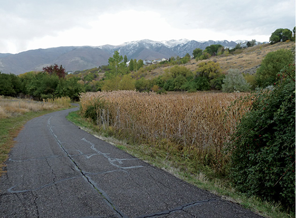
Western section of Kays Creek Parkway
URBAN WALKS
11
Kays Creek Parkway
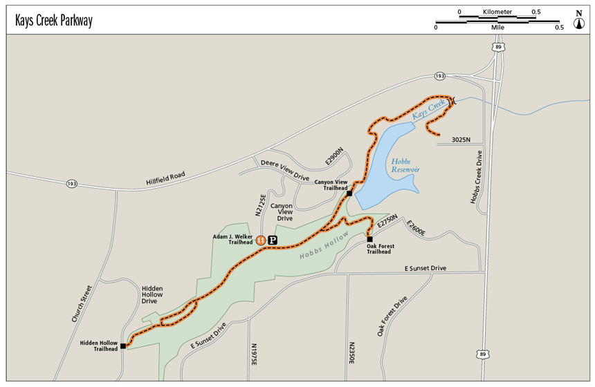
This Layton city park contains 4.5 miles of paved trails that run next to 100 acres of sometimes-dense vegetation and more-open marshland. Although just minutes from large subdivisions and busy streets, the park is a quiet retreat in the bottom of Hobbs Hollow. Running through Kays Creek corridor, the east side of the trail runs next to Hobbs Reservoir and often next to Kays Creek. It’s a quick retreat from the bustle of city life and a haven filled with a variety of wildlife and birds. Four trailheads provide a variety of access points, and the trails can be enjoyed in multiple directions. Pick one, or stroll them all.
Start: There are four trailheads: (1) Adam J. Welker trailhead, 2700 North 2125 East. This trailhead has twenty-five parking spaces and is considered the parkway’s primary trailhead. (2) Canyon View trailhead, 2360 East Canyon View. No parking available. (3) Oak Forest trailhead, 2459 East 2750 North. No parking available. (4) Hidden Hollow, 2210 North 1450 East. Parking possible along the roadside.
Distance: 4.5 miles of trails
Hiking time: About 30 minutes to 2 hours
Difficulty: Easy
Elevation gain: Adam J. Welker trailhead to Oak Forest trailhead, 225 feet; Adam J. Welker to dead end at Kays Creek, 190 feet; Adam J. Welker to Canyon View trailhead, 168 feet; Adam J. Welker to Hidden Hollow trailhead, negligible
Trail surface: Paved
Best season: Year-round access
Other trail users: Bikers, skateboarders, people in wheelchairs and pushing strollers
Canine compatibility: Leashed dogs permitted
Land status: City park
Nearest town: Layton
Fees and permits: No fees or permits required
Schedule: Open during daylight hours only
Maps: Layton city and Kays Creek Parkway maps available online at www.laytoncity.org
Trail contacts: Layton City Offices, Parks and Recreation Department, 437 North Wasatch Dr., Layton 84041; (801) 336-3900
Special considerations: No motorized vehicles or fires allowed. No restrooms are available at any trailhead. This is considered a cougar area.
Finding the trailhead: The Adam J. Welker trailhead is the only trailhead to provide parking, so it is the best trailhead for nonlocals. From Salt Lake City take I-15 north to the US 89 turnoff in front of Lagoon Amusement Park (exit 324). Follow US 89 for 8.7 miles to UT 193 West (exit 404) and go toward Clearfield/Hill Air Force Base. Turn left off the exit ramp onto UT 193/Bernard Fisher Highway and travel 1.1 miles. Turn left onto 2000 East and then left onto Deere View Drive and continue 0.1 mile. Turn right onto 2125 East and follow the road 0.4 mile to where it dead-ends at the trailhead and parking area. GPS: N41 05.867' / W111 55.687'
The Hike
For his Eagle Scout project, in 2008 a local Scout put up information signs along the trail describing the flora and fauna of the area. The signs provide information on raccoons, porcupines, deer, cougars, red-tailed hawks, mourning doves, spotted towhees, red foxes, and magpies—all found at different times of the year in this patch of nature amidst the city. The trail is lined with Russian olive trees, so during spring the aroma is divine. A variety of trees and undergrowth provide a haven for birds and wildlife, while pulling us out of neighborhoods and into a peaceful, quiet stroll along Kays Creek, for which the parkway is named. Hobbs Hollow, the canyon the park is located in, sits well below the numerous neighborhoods that rim the area.
The four different trailheads allow access to Kays Creek Parkway from various neighborhoods around the east side of Layton, but only one provides parking—Adam J. Welker. This land was provided by the Welker family, which donated 20 acres to the park project.
The park covers an underground sewer line that services the surrounding neighborhoods. There are plans that someday the trail will continue west, expanding to Layton Commons Park.
Western section of Kays Creek Parkway
Heading east for 0.3 mile from Adam J. Welker trailhead and parking lot, you will reach a fork in the trail. The right fork ascends 0.65 mile to Oak Forest trailhead, which sits in a neighborhood. The left fork takes you to the Canyon View access and farther into the hollow and to a Kays Creek bridge and crossing. There is a picnic table at the bridge crossing, and the trail continues for another 0.25 mile until it dead-ends at a grove of trees. It is 1.3 miles from Adam J. Welker trailhead to the dead end past Canyon View trailhead. Hobbs Reservoir, used for irrigation, is well fenced off on this east side of the parkway and dotted with No Trespassing signs. Though the trail skirts the reservoir, it is clear that the lake itself is out of bounds. Built in 1919 it is of earthen construction with a capacity of 1,580 acre-feet and drains an area of 2 square miles.
If you take the right fork from the aforementioned intersection and head west from Adam J. Welker trailhead toward the Hidden Hollow trailhead, the vegetation is more marshland than forest. In 0.35 mile the trail forks; both forks head in the same direction and loop back together in 0.2 mile. It is 0.7 mile to the Hidden Hollow trailhead.
Garbage cans and doggie potty bags are available at all trailheads. Enjoy any section of the trail or all for as long as you like, and then return to your car.
Miles and Directions
0.0Start at the Adam J. Welker trailhead.
0.7Reach the Oak Forest trailhead.
0.5Reach Canyon View access.
1.3Reach a dead end past the reservoir.
0.7Reach the Hidden Hollow trailhead.