MILL CREEK CANYON
19
Grandeur Peak
Church Fork picnic grounds welcome you with the sounds of a cascading waterfall—one of the nicest approaches to a trailhead. The popular and busy Grandeur Peak Trail takes you to overlooks of the Wasatch Front and surrounding canyons and valleys. The waterfall and stream flow generously in spring, making the trail especially pleasant. Fall brings gorgeous color, and all seasons bring great views across Mill Creek and the Wasatch Front. The hike climbs up Church Fork to the Mill Creek Ridge and then up to Grandeur Peak for the final 360-degree view. The first mile is nicely shaded; the rest of the trail is exposed and open, which results in great views, but you may want to hike this trail in the early morning or evening to avoid full sun exposure during midday.
Start: Grandeur Peak trailhead at the top of Church Fork picnic grounds
Distance: 6.4 miles out and back
Hiking time: About 4 hours
Difficulty: Moderate
Elevation gain: 2,451 feet
Trail surface: Asphalt, dirt and rock path
Best season: Spring through fall
Other trail users: None
Canine compatibility: Dogs permitted. Dogs must be leashed on even-numbered days; may be off-leash on odd-numbered days but must be in sight of handler. Dogs must be leashed at all times in campgrounds, on roadways, and at trailheads. Be sure to clean up after your dog.
Land status: Uinta-Wasatch-Cache National Forest; Boys Scouts of America land
Nearest town: Salt Lake City
Fees and permits: Fee to enter Mill Creek Canyon. The fee station is located at the bottom of the canyon; payment is requested upon exit.
Schedule: Gates to Church Fork picnic ground are closed from 10 p.m. to 8 a.m.
Maps: USGS Mount Aire, Sugar House; Trails Illustrated Wasatch Front (709)
Trail contacts: Salt Lake County Park Operations; (801) 483-5473 Public Lands Information Center, Recreational Equipment Inc., 3285 East 3200 South, Salt Lake City 84109; (801) 466-6411; www.publiclands.org Salt Lake Ranger District, 6944 South 3000 East, Salt Lake City 84121; (801) 236-3400
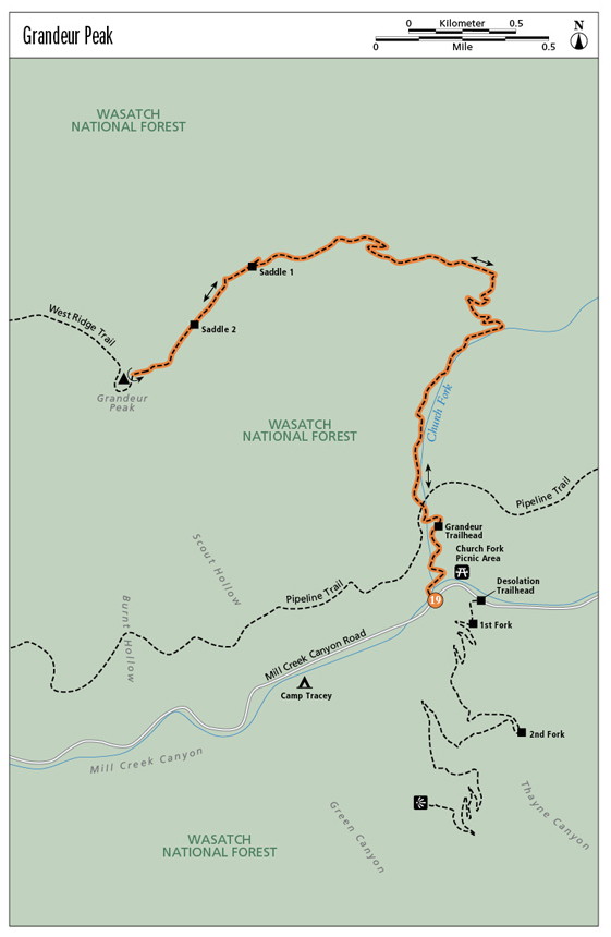
Finding the trailhead: The Church Fork picnic area lies 2.3 miles past the fee station in Mill Creek Canyon, located at the top of 3800 South off Wasatch Boulevard in Salt Lake City. Church Fork sits on the north side of the road. Hikers must park on the highway by the picnic area or at the top of the picnic area at the Grandeur Peak trailhead parking. Parking is not allowed in other picnic area sites. It is 0.35 mile from Church Fork, through the picnic area, to the Grandeur Peak trailhead. GPS: N40 42.043' / W111 44.546'
The Hike
Church Fork gained its name in 1854 when Abraham O. Smoot, assigned the task of building a structure to house sugar-making machines, petitioned the court for control of the timber in this fork. Since his work was at the bidding of the LDS Church, the fork became known as Church Fork. In the early 1900s the land became part of a mining claim that was later deeded to the Boy Scouts of America, with public access allowed.
Today the lower end of Church Fork holds a picnic ground through which you must walk along a paved road 0.35 mile to get to the Grandeur Peak trailhead on the far north end of the grounds. The walk is a pleasant jaunt past waterfalls and the stream that runs down Church Fork.
Grandeur Peak trailhead is marked with a kiosk, garbage cans, and doggie-waste bags. The trail transitions from pavement to dirt here. A few feet up the trail you’ll find a map; cross a bridge and continue 0.2 mile to the intersection with the Pipeline Trail, which runs perpendicular and downcanyon. Cross the Pipeline Trail and head north further up Church Fork.
The climb up Church Fork is consistently steep and travels next to the stream. The trail turns west 1.0 mile up; the dirt becomes red and the trail heads out of Church Fork, away from the stream to the Mill Creek Ridge. Here the view opens and you leave the shade of taller trees and enter the open exposure of low-lying scrub. Mill Creek Canyon and the surrounding mountains come into view. The trail quickly makes a hairpin turn. Take the turn and stay on the larger, more defined trail. At 1.8 miles the trail surface changes to chunky, orange-and-brown scree.
At 2.4 miles the trail comes to the first saddle at 7,600 feet. To the right in a few hundred feet is a no-name peak that makes a nice place to stop and take in the view. Views of Parley’s Canyon to the north and Mount Olympus to the south are additional eye candy from this grand ridge. Continue up the ridge to the left (southwest) to get to Grandeur Peak. At 2.6 miles you reach the second saddle view. Continue climbing east to the peak. The last 0.5 mile is a steep climb to the top. Return the way you came.
Miles and Directions
0.0Start at the Grandeur Peak trailhead.
0.2The trail intersects the Pipeline Trail.
1.0The trail exits Church Fork.
2.4Come to the first saddle.
2.6Reach the second saddle.
3.2Reach Grandeur Peak. Return the way you came.
6.4Arrive back at the trailhead.
Hike Information
Local events and attractions: Picnic tables, pit toilets, and drinking water are available at the Church Fork picnic grounds. Reservations can be made at (801) 483-5473 for June 1 through Sept 30. Reservations must be made at least five days in advance. Two group sites seat up to 50 people each.
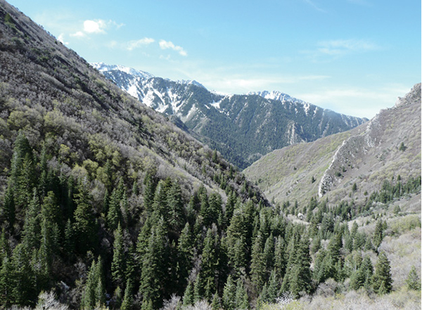
View across Mill Creek Canyon