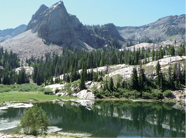
Lake Blanche with Sundial Peak in the background
BIG COTTONWOOD CANYON
22
Lake Blanche
This is not the road less traveled. Though the climb is strenuous, the trailhead is easily accessible, the trail straightforward, and the destination a scenic glacial tarn at the base of Sundial Peak, which lords over the cirque below. One of the area’s more popular hikes, it provides a climb through shaded forest, up canyon meadows, and over glacially cut quartzite to three lakes at the top of the canyon: Lake Blanche and her sister lakes, Lillian and Florence, to the west. Slabs of quartzite and the surrounding forests allow space and time for reflection and exploration once you reach the lakes at the top.
Start: East side of the Mill B South trailhead
Distance: 7.0 miles out and back
Hiking time: About 4.5 hours
Difficulty: Strenuous
Elevation gain: 2,720 feet
Trail surface: Sidewalk, packed-dirt path, rock, boulders, and talus
Best season: Late spring through early fall; avalanche hazard during winter months
Other trail users: None
Canine compatibility: Dogs prohibited
Land status: Twin Peaks Wilderness Area of the Uinta-Wasatch-Cache National Forest
Nearest town: Midvale
Fees and permits: No fees or permits required
Maps: USGS Mount Aire
Trail contacts: Public Lands Information Center, Recreational Equipment Inc., 3285 East 3200 South, Salt Lake City 84109; (801) 466-6411; www.publiclands.org Salt Lake Ranger District, 6944 South 3000 East, Salt Lake City 84121; (801) 236-3400 Uinta-Wasatch-Cache National Forest, 8236 Federal Building, 125 South State St., Salt Lake City 84138; (801) 236-3400; hours Mon through Fri 8 a.m. to noon and 1 to 4:30 p.m.; closed holidays
Special considerations: Due to the wilderness area and watershed status, no campfires, dogs, horses, or bicycles are allowed. All backcountry camping must be at least 200 feet away from trails, lakes, or streams. There is a limit of 10 campers per group.
Finding the trailhead: In Salt Lake City take I-215 south to 6200 South (exit 6). Turn east off the exit and continue along 6200 South as it changes to Wasatch Boulevard for 1.7 miles to the mouth of Big Cottonwood Canyon (UT 190). Turn left (east) at the signal and head 4.2 miles up the canyon to the Mill B South trailhead. The trailhead sits just before the S curves in the road on the right (south) side of the road. If the good-size parking lot is filled, hikers park out along the canyon road. GPS: N40 37.994' / W111 43.420'
The Hike
Lake Blanche lies in the upper section of Mill B South Fork. This area has been popular with hikers since the late 1800s when the lakes were named for the daughters of artists Henry L. A. Culmer and Alfred Lambourne. Lake Blanche was named for Blanche Cutler by a friend of Culmer and Lambourne. The names were publicized in their writings and thus stuck. Lambourne was also responsible for the naming of Sundial Peak. The lakes were called the Three Sisters, and the drainage in which they lay was called Hidden Valley. Lambourne was so taken by Hidden Valley that he once spent a summer there, recording his experience in a notebook for others who came after. Today the three lakes have been dammed and are larger than they were in Lambourne’s day.
The trail to Lake Blanche begins near the restroom on the east side of the trailhead. The walkway starts out paved and after 0.25 mile takes off to the right on a trail of dirt and boulders. A sign marker indicates the trail intersection.
Soon after entering the trail, it forks (0.3 mile). Take the left fork and stay on the main trail over the bridge in front of a memorial bench. From here the trail crosses to the north side of the creek and begins its climb up into the canyon. At 0.5 mile the trail enters the Twin Peaks Wilderness area of the Uinta-Wasatch-Cache National Forest. A stream accompanies the trail for this first section as you steadily climb east into the canyon. The trail is well defined and easy to follow.
Lake Blanche with Sundial Peak in the background
At 3.0 miles the trail changes from its eastern route and begins to switchback up the south-facing mountain to reach the upper cirque. When the trail runs into a quartzite boulder slide, make a small, sharp U-turn and continues off the slide boulders to the east, where the trail continues. Within a few hundred feet other large quartzite formations become visible. Make your way across these interesting, glacially carved rocks to stay on the trail. Quartzite is prominent the rest of the way to Lake Blanche. Notice the striations on the quartzite that are still visible from the glacial carving that took place during the canyon’s creation.
You cannot see Lake Blanche until you’re right upon it. An old dam wall shows past lake boundaries. Follow the wall to crest the rock and look down upon the lake. Head west to the broken dam you can see on the other side of Lake Blanche, from which vantage point you can see Lake Florence and Lake Lillian. The old dams were built in the 1930s to contain much larger lakes. Lake Blanche’s western dam broke in 1983. Footpaths are visible around all three lakes.
Sundial Peak is the majestic mountain that overlooks Lake Blanche from the east. It is as much an attraction as Lake Blanche itself. Take time to enjoy the scenery and peaceful lakeside ambiance before returning the way you came.
Big Cottonwood Canyon is bounded on the south by the Lone Peak Wilderness Area and on the north by the Mount Olympus Wilderness Area.
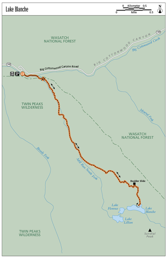
Miles and Directions
0.0Start at Mill B South trailhead.
0.25Exit the paved path onto a dirt trail.
0.3Come to your first fork; head left on the main trail, crossing the bridge.
0.5Enter Twin Peaks Wilderness Area.
3.0The trail starts switchbacking up the south-facing mountain to climb to the cirque.
3.1Come to the quartzite boulder slide.
3.5Arrive at Lake Blanche. Return the way you came.
7.0Arrive back at the trailhead.
Hike Information:
Camping: The Salt Lake Ranger District manages three campgrounds up Big Cottonwood Canyon (UT 190): Jordan Pines, Spruces, and Redman. Jordan Pines is located 8.8 miles up Big Cottonwood Canyon. To reach the campground turn right onto Cardiff Fork Road across from the Mill D trailhead. The entrance is 0.25 mile from UT 190. Camping at Jordan Pines is by reservation only, and the campground is well suited for groups. Spruces Campground, the largest campground in the Salt Lake Ranger District, is 9.7 miles up Big Cottonwood Canyon. It has 97 campsites with tables, grills, and fire circles. Redman Campground is 13 miles up Big Cottonwood Canyon and has 43 campsites. There are no RV hookups, and most sites are first-come, first-served.
Camping is permitted in designated campgrounds only. For reservations call the National Recreation Reservation Service at (877) 444-6777 or go to www.reserveusa.com.
Guide services: Gone Hiking: For guided hiking retreats in the area go to: www.UtahHikingRetreat.com or call (801) 663-6964.