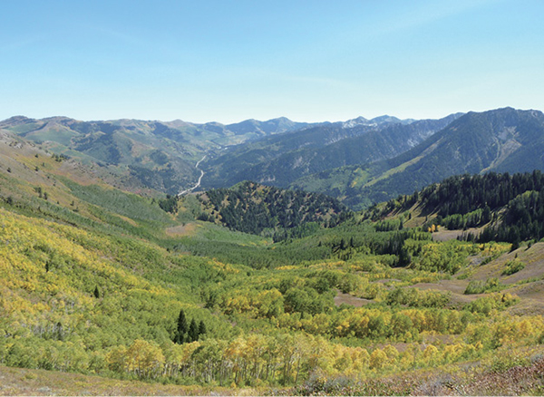
View from Mount Raymond up Big Cottonwood Canyon
BIG COTTONWOOD CANYON
24
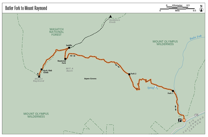
Butler Fork to Mount Raymond
The hike to Mount Raymond via Butler Fork provides a rich selection of eye candy and experiences: lush aspen forests, open views up Big Cottonwood Canyon, fun rock scrambling, 360-degree summit views, and the challenge of a vertical climb combined with strolling through an aspen grove. It’s a winning combination that takes you to a 10,241-foot peak. In fall the aspens spread gold across the canyon, and during summer’s wildflower season Mount Raymond is dotted with color.
Start: Butler Fork trailhead
Distance: 7.8 miles out and back
Hiking time: About 4.5 hours
Difficulty: Strenuous
Elevation gain: 3,100 feet
Trail surface: Dirt and rock path
Best season: Summer and fall
Other trail users: None
Canine compatibility: Dogs prohibited
Land status: Uinta-Wasatch-Cache National Forest; Walter F. Mueggler–Butler Fork Natural Research Area; Mount Olympus Wilderness Area
Nearest town: Brighton
Fees and permits: No fees or permits required
Maps: USGS Mount Aire
Trail contacts: Public Lands Information Center, Recreational Equipment Inc., 3285 East 3200 South, Salt Lake City 84109; (801) 466-6411; www.publiclands.org Salt Lake Ranger District, 6944 South 3000 East, Salt Lake City 84121; (801) 236-3400 Uinta-Wasatch-Cache National Forest, 8236 Federal Building, 125 South State St., Salt Lake City 84138; (801) 236-3400; hours Mon through Fri 8 a.m. to noon and 1 to 4:30 p.m.; closed holidays
Finding the trailhead: From Salt Lake City take I-215 south to 6200 South (exit 6). Turn left (east) off the exit and continue for 1.7 miles (6200 South becomes Wasatch Boulevard) to the mouth of Big Cottonwood Canyon (UT 190). Turn left at the signal onto UT 190 and drive 8.2 miles up Big Cottonwood Canyon to the small parking area and trailhead on the left side of the road. GPS: N40 38.963' / W111 39.707'
The Hike
Mount Raymond is one of the most prominent peaks on the north side of Big Cottonwood Canyon. The well-defined trail runs through a protected area called the Walter Mueggler–Butler Fork Natural Research Area. The area serves as a high-quality control area for the study of natural ecological processes. It was established here in the Butler Fork drainage because although most of Utah’s aspen stands have experienced moderate to heavy impacts from mining, logging, and cattle, this drainage has been excluded from such invasions for more than one hundred years. The aspen communities in this 1,270-acre natural research area are as pristine as can be found in this region. Butler Fork was named for the Butler brothers, who established a steam sawmill in the fork in 1877.
The trail begins next to a stream as it heads up the Butler Fork drainage, and as you cross the stream on wooden bridges and low water areas, the stream moves from the right to the left side of the trail. Nice tall evergreens and a spattering of the quaking aspens you will see farther up the trail shade some sections, while other sections of the trail open up to the sun.
The trail enters the Mount Olympus Wilderness Area at 0.4 mile and you reach the first signed intersection at 0.5 mile. Head toward Mill A Basin whenever the trail signs give you the option. The stream continues for the first 0.75 mile of the trail, and at 1.3 miles you break out of the trees and gain a view down Butler Fork and Big Cottonwood Canyon.
At 1.7 miles you get your first good look to the west at the big rocky slab face of Mount Raymond. You also get your first look at some of Big Cottonwood's tallest peaks across the canyon on the south side. Twin Peaks (11,302 feet) sits to the west; Sundial Peak (10,282 feet) sits to the south. This is a nice vantage point for locating and identifying the peaks and drainages that surround you.
View from Mount Raymond up Big Cottonwood Canyon
At 1.9 miles you enter the aspen groves that stretch across Mill A Basin, and the climb slows to a stroll through the beautiful, colorful aspen. A few hundred feet later a trail junction points you left toward Mill A Basin or right to Dog Lake. Head toward Mill A Basin.
At 2.2 miles the view opens to the south. The two peaks on the far west are Twin Peaks, the peak east of this is Dromedary, the next peak is Sunrise, and the peak that is covered with trees and sitting in the forefront is Mount Kessler. From here the trail continues to scoot through the aspen. At 3.0 miles you come to the first unmarked trail junction. The left fork heads down past the foot of Mount Raymond into Mill A Basin; the right fork goes up to the Baker Pass saddle between Mount Raymond and Gobblers Knob. Take the right fork and climb out of the trees to the saddle. Here, above the tree line, the trail heads along the ridge to the southwest and the trail becomes a stairway of crumbly limestone and quartzite. The trail follows steeply along the ridge and winds down to the west side a bit as it makes its way up to the summit. From the saddle to the top you have expansive views the entire 0.7 mile.
As you get closer to the summit, the rock piles become larger and the trail becomes less defined. You can see the summit, so you know the direction you are heading, but the last 0.2 mile is all rock scrambling to make it to the summit. At 3.8 miles you’ll have to climb up a sheer striated rock slab to continue. The thin trail picks up again as it weaves through the rock piles to the top.
The Mount Raymond summit is a pile of rocks from which you have 360-degree views west over the Salt Lake Valley, Kennecott Copper mine, and the Great Salt Lake. To the north lies Mill Creek Canyon. For those familiar with the stark steepness of Little Cottonwood Canyon, this vantage point accentuates the difference between the two canyons as you note the rolling nature of Big Cottonwood Canyon to the east. A USGS marker marks the summit. Return the way you came.
Three major physiographic provinces are found within the state of Utah: the Rocky Mountain Province, the Great Basin Province, and the Colorado Plateau.
Miles and Directions
0.0Start at the Butler Fork trailhead.
400 feetCome to a bridge crossing.
0.4Enter Mount Olympus Wilderness Area.
0.5Reach the first trail intersection; continue toward Mill A Basin.
1.3The trail breaks from the trees for views down Butler Fork.
1.7Enjoy your first sighting of Mount Raymond.
1.9Enter the aspen groves.
1.95Come to the second trail intersection; head left toward Mill A Basin.
2.2The view to the south opens for a ridgeline view of the south side of Big Cottonwood Canyon.
3.0Come to an unmarked trail intersection; head right to climb to the saddle.
3.2Arrive at the saddle of Baker Pass.
3.8Come to a rock slab that must be climbed.
3.9Arrive at the summit of Mount Raymond. Retrace your steps to the trailhead.
7.8Arrive back at the trailhead.
Option
From the saddle at Baker Pass you can head northeast and take in the hike to Gobblers Knob, which is only 5 feet higher than Mount Raymond. This route climbs 900 feet in 0.8 mile for a total out-and-back hike of 8 miles. Many hikers will hit both peaks in one day.
Hike Information
Camping: The Salt Lake Ranger District manages three campgrounds up Big Cottonwood Canyon (UT 190): Jordan Pines, Spruces, and Redman. Jordan Pines is located 8.8 miles up Big Cottonwood Canyon. To reach the campground turn right onto Cardiff Fork Road across from the Mill D trailhead. The entrance is 0.25 mile from Big Cottonwood Road (UT 190). Camping at Jordan Pines is by reservation only, and the campground is well suited for groups. Spruces Campground, the largest campground in the Salt Lake Ranger District, is 9.7 miles up Big Cottonwood Canyon. It has 97 campsites with tables, grills, and fire circles. Redman Campground is 13 miles up Big Cottonwood Canyon and has 43 campsites. There are no RV hookups, and most sites are first-come, first-served.
Camping is permitted in designated campgrounds only. For reservations call the National Recreation Reservation Service at (877) 444-6777 or go to www.reserveusa.com.
Guide services: Gone Hiking: For guided hiking retreats in the area go to: www.UtahHikingRetreat.com or call (801) 663-6964.
Green Tip:
Toilet paper should be burned or carried out. To carry it with you, add a small piece of an ammonia-soaked sponge in your bag to help kill bacteria and odor.