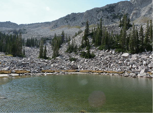
The southern shore of the top Maybird Lake
LITTLE COTTONWOOD CANYON
29
Maybird Lakes
Maybird Lakes (there are three) sit at the top of Maybird Gulch at the base of the Pfeifferhorn, which towers 11,326 feet above. More like ponds, these lakes nestle in an area that is beautiful in a dramatic and destructive tone. Granite boulders of all sizes have crumbled from the mountains above and surround the lakeshores. This leg off the Red Pine Lakes Trail affords more solitude and is less used but is no less beautiful and a bit more dramatic. The trail takes you to the middle lake, where you can enjoy the surrounding effects of a steep gulch and a high-mountain lake.
Start: White Pine trailhead
Distance: 7.8 miles out and back
Hiking time: About 3 hours
Difficulty: Moderate
Elevation gain: 2,000 feet
Trail surface: Dirt path with rocks and roots, bridge
Best season: Summer and fall; snow in these upper elevations until mid-June
Other trail users: None
Canine compatibility: Dogs prohibited
Land status: Uinta-Wasatch-Cache National Forest; watershed
Nearest town: Sandy
Fees and premits: No fees or permits required
Maps: USGS Dromedary Peak
Trail contacts: Public Lands Information Center, Recreational Equipment Inc., 3285 East 3200 South, Salt Lake City 84109; (801) 466-6411; www.publiclands.org Salt Lake Ranger District, 6944 South 3000 East, Salt Lake City 84121; (801) 236-3400 Uinta-Wasatch-Cache National Forest, 8236 Federal Building, 125 South State St., Salt Lake City 84138; (801) 236-3400; hours Mon through Fri 8 a.m. to noon and 1 to 4:30 p.m.; closed holidays
Finding the trailhead: From Salt Lake City drive south on I-215 to 6200 South (exit 6). Turn left off the ramp and follow 6200 South past Big Cottonwood Canyon, where the road becomes Wasatch Boulevard. Little Cottonwood Canyon is located 4 miles past the mouth of Big Cottonwood Canyon. Continue straight until you reach the park-and-ride lot at the base of the canyon. From here the White Pine trailhead is 5.6 miles upcanyon, just past Tanner’s Campground. White Pine trailhead is a large, busy trailhead with restrooms and room for forty-plus cars. If the lot is full, cars can be parked along the road. GPS: N40 34.530' / W111 40.843'
The Hike
This trail is one of three trails (White Pine and Red Pine Trails are the other two) that start at this same trailhead.
The Maybird Gold, Silver and Lead Mining Company claim was filed in June 1874. Like most of the other names in Little Cottonwood Canyon, the name of this gulch was derived from its history in mining.
The trail begins on the south side of the parking area next to the restrooms and follows a small paved path down to the bridge and official White Pine trailhead. The trail crosses the bridge over Little Cottonwood Creek and then cuts west and south as it makes its way into the steep side canyons that dump into Little Cottonwood Canyon.
The southern shore of the top Maybird Lake
The trail is easy to follow, and the first 1.0 mile is a pleasant alpine jaunt up White Pine Canyon to the White Pine/Red Pine junction, where the trails to White Pine and Red Pine Lakes diverge. Maybird Gulch is an offshoot from the Red Pine Lake Trail, so from the junction follow the trail that winds behind the kiosk trail sign and heads into Red Pine Canyon. A couple hundred feet up the trail you hit the Red Pine bridge and cross the stream. The trail into Red Pine Canyon begins heading west over roots, wooden bridges, and a rock-strewn trail before it begins the consistent climb into Red Pine Canyon. At 1.4 miles you enter the Lone Pine Wilderness Area, where the aspen and evergreens shade and cool. At 1.5 miles the view down Little Cottonwood Canyon opens into the Salt Lake Valley below.
The most difficult aspect of this trail is the consistent climb up Red Pine Canyon to the lakes at the top. At 2.7 miles and an elevation of 8,950 feet the Maybird Gulch Bridge exits the Red Pine trail. Cross this bridge and follow the singletrack trail as it heads west. Once the trail climbs out of Red Pine Canyon, the hike becomes a level, pleasant stroll through the trees as you head into Maybird Gulch. As you travel west you can see across Little Cottonwood Canyon to the steep cliff walls that make up the other side of the canyon.
At 3.3 miles (0.6 mile from the bridge), the trail winds into Maybird Gulch and begins to climb up boulders and roots. As the trail crests the top of the hill, big chunks of granite that define the upper canyon take over the landscape. The trail makes a small dip into the trees below. Maybird’s middle lake sits 1.2 miles from the Maybird bridge, or 3.9 miles from the White Pine trailhead.
A nice grove next to the lake provides logs and rocks to rest on. There is no wading or swimming in these watershed lakes, but you can enjoy the dramatic scenery before returning the way you came.
During winter this area is prone to long and violent avalanches. As you hike, see if you can find the debris from past avalanche paths.
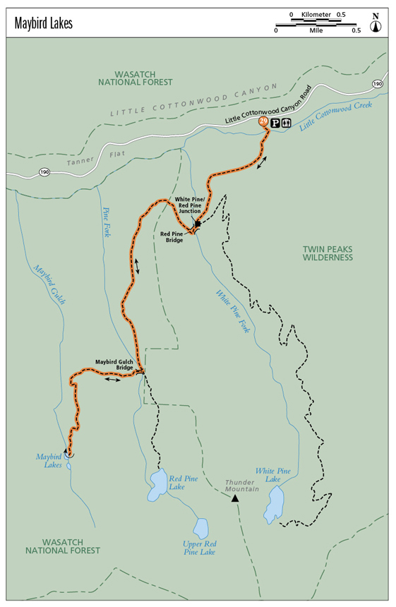
Miles and Directions:
0.0Start at the White Pine trailhead.
1.0Arrive at the White Pine/Red Pine junction; follow the trail that winds behind the kiosk trail sign.
1.4Enter Lone Peak Wilderness Area.
1.5Views down Little Cottonwood Canyon open up.
2.7Arrive at the Maybird bridge; cross here and exit the Red Pine Trail.
3.3The trail rounds into Maybird Gulch.
3.9Arrive at Maybird Lake. Return the way you came.
7.8Arrive back at the trailhead.
Hike Information
Local events and attractions: Wasatch Wildflower Festival; www.wasatchwildflowerfestival.org; usually held the end of July and celebrated primarily at the four main ski resorts in both Big and Little Cottonwood Canyons—near the top of both canyons. The Wasatch Wildflower Festival is a collaboration between the nonprofits Alta Community Enrichment, The Cottonwood Canyons Foundation, and The Snowbird Renaissance Center. It is also supported through the efforts of Alta Ski Area, Snowbird Ski and Summer Resort, Solitude Ski Area, Brighton Ski Area, and the US Forest Service.
Camping: Tanner’s Flat Campground is located a mile before White Pine trailhead in Little Cottonwood Canyon. Shaded with pine and aspen, Little Cottonwood Creek runs through the campground; fishing is allowed in the stream. Some of the 57 sites are available on a first-come, first-served basis. Reservations for other sites must be made at least three days in advance at www.reserveamerica.com.
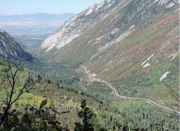
Midtrail view down Little Cottonwood Canyon into the Salt Lake Valley