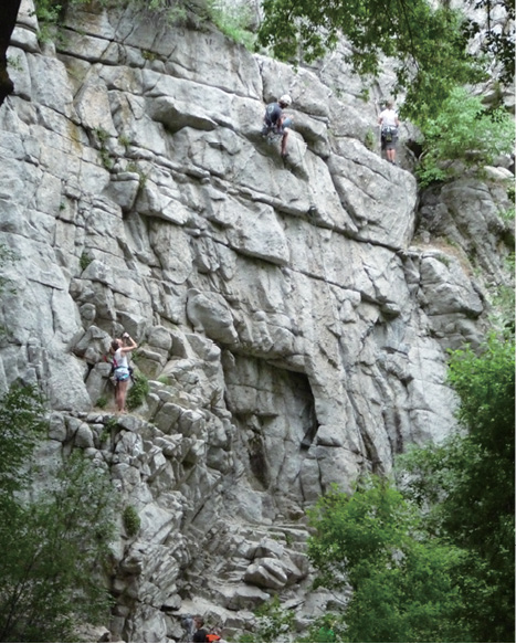
Rock climbers in Ferguson Canyon
FERGUSON CANYON
31
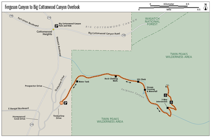
Ferguson Canyon to Big Cottonwood Canyon Overlook
One of the lesser known canyons of the Wasatch, Ferguson Canyon is a hidden gem. Access doesn’t get easier—the trailhead is located right outside a Cottonwood Heights neighborhood—and the trail has the best of all worlds. Once inside the canyon the trail climbs beneath a lush canopy of shade trees as it parallels a stream fraught with moss-and-fern-adorned waterfalls. You’ll enjoy granite cliffs and formations, a fun tree arch over the trail, and ultimately an overview that takes in the sweep of the Salt Lake Valley as well as an unobstructed view into Big Cottonwood Canyon. The trail is a steady and consistent climb—you’ll feel like you’ve had a workout once you get back to the car.
Start: Ferguson Canyon trailhead
Distance: 4.0 miles out and back
Hiking time: About 2.5 hours
Difficulty: Strenuous
Elevation gain: 1,400 feet
Trail surface: Doubletrack gravel trail, rock stairs, stream crossings, silt hill, singletrack, boulders
Best season: Early summer through fall
Other trail users: None
Canine compatibility: Leashed dogs permitted. Owners must clean up after pets; doggie-refuse bags are available at the trailhead.
Land status: Cottonwood Heights, Uinta-Wasatch-Cache-National Forest—Twin Peaks Wilderness Area
Nearest town: Cottonwood Heights
Fees and permits: No fees or permits required
Schedule: Trail and trailhead closed 10 p.m. to 6 a.m.
Maps: USGS Draper, Dromedary Peak
Trail contacts: Trail maintenance; (801) 943-3190 Salt Lake Ranger District, 6944 South 3000 East, Salt Lake City 84121; (801) 236-3400
Special considerations: Watch out for patches of stinging nettle next to the stream.
Finding the trailhead: Because it sits right in a neighborhood, the Ferguson Canyon trailhead has an address: 7743 South Timberline Dr., Cottonwood Heights 84121. From Salt Lake City take I-215 south to 6200 South (exit 6) and head east off the ramp. Follow 6200 South until it becomes Wasatch Boulevard then continue 0.3 mile past Big Cottonwood Canyon to Prospector Drive (7535 South). Turn left onto Prospector Drive and then take a quick right. Follow the road 0.4 mile and turn left onto Timberline Drive (7780 South). The trailhead is on the right-hand side of the road, with a total of sixteen parking spaces on both sides of the trailhead. There are no facilities at the trailhead. GPS: N40 36.622' / W111 47.292'
The Hike
The Wild West is full of legends, one of which is the legend of Ferguson Mine. An early pioneer named Ferguson did some prospecting in the canyons east of what is now Cottonwood Heights. According to the legend, one day Mr. Ferguson came out with some gold ore and claimed there was a whole ledge of the stuff. He first reported his discovery to Brigham Young, leader and prophet of the Mormons who had settled Utah. Young asked him to go back and cover up the gold and forget it for the time being because a gold rush would end the isolation the Mormons came here for. Ferguson complied. Many years later Ferguson started up the mountain with his family to show them were the gold vein was but had a heart attack and died before he could reach the spot. The purported Ferguson Mine has never been found.
As you begin your exploration of Ferguson Canyon, you’ll start out on a gravel doubletrack that leads up and out of the Cottonwood Heights neighborhood, all the while enjoying open views of the surrounding neighborhood and even over the valley. The trail passes a water tank at 0.25 mile, and then the trail transitions into a singletrack as it quickly descends into Ferguson Canyon. The trail begins next to scrub oak and grasses, but as you enter the canyon the lush riparian area is filled in with ferns, mossy rocks, maples, cottonwoods, and oaks. Once in the canyon the trail parallels a stream that you will follow all the way upcanyon. The sounds of the stream and the supreme shade from the trees make this a peaceful if strenuous hike as you climb your way to the top of the canyon.
At 0.7 mile the trail passes next to granite slab walls, a favorite rock climbing spot. There is a good chance you’ll run into climbers along the trail. The trail runs next to granite walls and formations all along this midsection. A hundred feet later the trail appears to fork. The right fork is littered with rock “steps”; these are belay platforms for the climbers. The trail continues to the left.
Rock climbers in Ferguson Canyon
At 1.0 mile you make the first of several river crossings on logs. During spring the water will be higher, and it may be harder to keep your feet dry. Just after this first crossing, the trail becomes a steep climb up a “silt” mountain. The trail climbs up this loose, light dirt for 0.1 mile. At 1.25 miles you come to a waterfall and a second stream crossing. Take time to enjoy the lush peace of the waterfalls. This hike is as much about the journey as the destination.
At 1.6 miles the trail turns north and begins the climb up and out of Ferguson Canyon. The last 0.4 mile contains a couple of switchbacks before the trees begin to open and give way to the view. Just 0.2 mile after starting the climb out, you get your first views out over Salt Lake Valley and the Great Salt Lake.
At 1.7 miles the trail comes to a three-way intersection; head right (east). There are two nice viewpoints before you reach the end of the trail. Enjoy the views that reach all the way to downtown Salt Lake City to the north and south to the Kennecott Copper Mine. The Oquirrh Mountains lie to the west, and the Salt Lake Valley spreads between them.
At the end of the trail (2.0 miles) you are treated to a view directly into Big Cottonwood Canyon. From here you can see the cars snaking their way up the canyon and the park-and-ride lot at the bottom of the canyon, as well as all the aforementioned sights. One of my favorite views from here is back down Ferguson Canyon, where you can gain an appreciation of all you have just hiked through: the water tank, the canopy of trees, and the steady climb you just conquered. It’s fun to see your route from the bird’s-eye perspective. The trail ends at the overlook. Return the way you came.
Miles and Directions
0.0Start at the Ferguson Canyon trailhead.
0.25Pass a water tank.
0.7Reach the rock climbing walls.
1.0Cross the river on logs and begin a steep climb up the trail.
1.25Come to a waterfall and the second stream crossing.
1.6The trail begins to climb out of Ferguson Canyon toward the overlook.
1.8Reach a nice viewpoint.
2.0The trail ends at Big Cottonwood Canyon overlook. Return the way you came.
4.0Arrive back at the trailhead.
Hike Information
Local events and attractions: Wasatch Wildflower Festival: www.wasatchwildflowerfestival.org
Camping: There are two campgrounds located in Little Cottonwood Canyon: Tanner’s Flat and Albion Basin. Tanner’s Flat is located at an elevation of 7,200 feet; there are 36 sites available. Albion Basin sits at the top of Little Cottonwood Canyon at an elevation of 9,500 feet. There are 24 sites, and they fill quickly. The campground is located along the dirt road past Alta ski resort. Reservations must be made at least three days in advance at www.reserveamerica.com.