UTAH COUNTY
39
Stewart’s Cascades (Stewart Falls)
The Timpanogos area is rife with waterfalls, but Stewart’s Cascades, also known as Stewart Falls, are the easiest to access and possibly one of the most scenic. Popular with families, this pleasant, easy trail is often shaded and ends in a beautiful two-tiered waterfall that plunges 200 feet down the mountain. Fall colors are vibrant in this area, but the falls flow with greater intensity earlier in the year. Fir, aspen, and maple surround you in an alpine environment that makes for a dazzling day hike.
Start: Aspen Grove/Timpanogos trailhead
Distance: 3.8 miles out and back
Hiking time: About 1.5 hours
Difficulty: Easy
Elevation gain: 310 feet
Trail surface: Gravel and dirt path
Best season: Summer and fall; winter avalanche hazard
Other trail users: Horses
Canine compatibility: Leashed dogs permitted
Land status: Uinta-Wasatch-Cache National Forest; trail mostly on Sundance Resort property
Nearest town: Provo
Fees and premits: Fees required to access Aspen Grove trailhead
Maps: USGS Aspen Grove
Trail contacts: Pleasant Grove Ranger District; (801) 785-3563
Finding the trailhead: From Salt Lake City take I-15 south toward Las Vegas/Cheyenne. Take the UT 52/800 exit (272) toward US 189. Turn left onto UT 52 and follow for 3.7 miles where the road merges onto Provo Canyon Road. From the mouth of Provo Canyon, head 6.8 miles to the turnoff to Sundance ski resort/UT 92. Turn north and travel 4.5 miles past the Sundance ski area and past the BYU Aspen Grove Alumni Center to the Aspen Grove/Timpanogos trailhead that sits just past the US Forest Service fee booth. The trail takes off on the right side of the restrooms on the west side of the huge parking lot. GPS N40 24.25' / W111 36.315'
The Hike
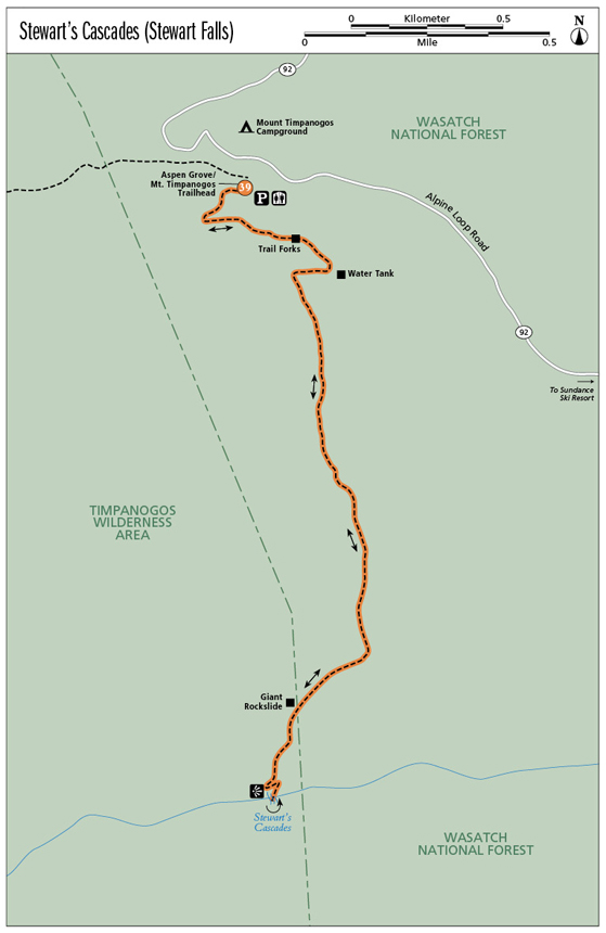
Stewart’s Cascades Trail leaves from the southwest side of the parking lot on the trail just north of the restrooms. A trail marker 130 feet up the trail directs you left to Stewart’s Cascades, Trail 56. The trail quickly turns southeast and climbs into a forest of tall evergreens. The view from this corner looks back over lush Primrose Cirque.
At 0.35 mile the trail forks, with the left fork descending to the BYU Alumni Center and the right fork continuing to Stewart’s Cascades. As the trail progresses you pass a big water tank on the left where the BYU Alumni Center stores their water.
The trail winds through old evergreens and young aspen groves and tall, lush ferns during spring and summer. At 1.4 miles the trail forks; continue straight. As you continue around the mountain, Sundance Resort becomes visible, with ski runs cutting through the trees. Privately owned homes cut into the mountains and beautiful foliage that covers the area. The last section of the trail becomes rockier. The trail to Stewart’s Cascades runs through areas that can be ravaged by avalanches during the winter months. You will see evidence of past slides.
The trail reaches an elevation of 7,200 feet before descending 300 feet to the upper falls. Rocky slabs provide a lookout point over the falls. Continue down the trail marked “Sundance” to the lower falls, where you can enjoy the full scope of the falls. After enjoying the area’s scenic beauty, return the way you came.
Miles and Directions
0.0Start at the Aspen Grove/Timpanogos trailhead.
130 feetCome to the sign for Stewart’s Cascades; turn left.
0.35The trail forks; go right.
0.5Pass a BYU water tank off to the left.
1.4The trail forks; continue straight.
1.65Pass a giant rockslide.
1.8Come to the viewpoint for the upper falls.
1.9Reach the base of the lower falls. Return the way you came.
3.8Arrive back at the trailhead.
Option
During summer and fall, hikers can ride Sundance Resort’s chairlift to mid-mountain (7,150 feet), where a pleasant downhill stroll brings you in from the south to Stewart’s Cascades at 6,800 feet.
Hike Information
Local events and attractions: Sundance ski resort, owned by Robert Redford, offers lift-assisted hiking and mountain biking in the summer months. The resort also offers artistic programs and outdoor theater. For information call (877) 831-6224 or visit www.sundanceresort.com. For guided hiking retreats in the area go to www.UtahHikingRetreat.com.
Scenic drive: The Alpine Loop begins near the Aspen Grove/Timpanogos trailhead and winds up the mountain into American Fork Canyon. Considered one of the most scenic drives in the state, especially in fall, it has been designated as a Utah scenic byway.
Camping: Mount Timpanogos Campground sits at an elevation of 7,600 feet and is located just a few hundred feet past the Aspen Grove/Timpanogos trailhead. Sheltered by aspen and fir trees, the campground has vault toilets and drinking water. Reservations are suggested during busy summer months. Campers also must have a recreation pass. Passes can be purchased as you enter the Alpine Loop from either end or from one of the self-service fee tubes located at major trailheads. No trailers or RVs longer than 20 feet. This park has first-come, first-served sites. For reservations call (877) 444-6777 or www.recreation.com. Theater in the Pines is a group campground located on the south side of the Aspen Grove/Timpanogos trailhead. Reservation only; call (877) 444-6777.
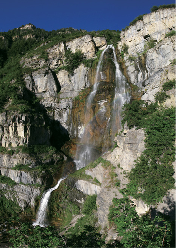
Stewart’s Cascades Mike Scabra
Green Tip:
Rechargeable batteries reduce one source of toxic garbage.