{ 6 }
NORTH OLIVER TO OKANAGAN FALLS
15 km, all paved
This route goes through one of the most spectacular and naturally diverse landscapes in southern British Columbia.
START: Okanagan River Bridge on Highway 97 about 5 km north of Oliver; drive north on Highway 97.
THIS ROUTE BEGINS at the bridge where Highway 97 crosses the Okanagan River north of Oliver; the junction with Tugulnuit Lake Road is just 100 metres to the east. The view is dominated to the north by the massive face of McIntyre Bluff on the west and another sheer rock face on the east.
The reach of the Okanagan River from here north to McIntyre Bluff is the only Canadian section of the river still in its natural course. This section was not channelized, because it is an important sockeye salmon spawning ground. You can see numbers of these large, scarlet fish in September and October as they jockey for position in the gravelly shallows. They have come all the way from the Pacific Ocean, up the Columbia River, climbing fish ladders over eleven large dams, to spawn at this site as their ancestors have for millennia. This is one of only two large spawning populations of sockeye left in the Columbia system; the other is along the Wenatchee River in Washington. Though no one knows how many salmon spawned here annually before the dams were built, it was probably in the hundreds of thousands. Recent spawning populations have numbered between five and ten thousand, with occasional years of good returns. The latest run (2008) was one of those good years, with more than sixty thousand big, red fish in the river.
There are continuing initiatives to rejuvenate this stock of salmon. One of the most exciting plans is to allow the river to revert back to a more natural channel where possible. This could greatly increase the available spawning area and also encourage the growth of natural riverside vegetation. Not only are these riparian woodlands important for keeping the river water clean and cool, they are one of the most endangered ecosystems in the valley, so any action that would increase their area would be doubly valuable. If you have time, stop and walk or bike down the paved trail along the west side of the river south to Oliver. The wildlife watching along the trail is excellent, even in winter, when you might spot an American dipper bobbing on a midriver rock.
Continuing north, you pass the big rock cliffs on the east side of the road above Gallagher Lake, a small lake obscured behind pines. These cliffs were the first place in Canada where spotted bats were discovered roosting. This bat looks like a tiny flying skunk (though it is big for a local bat), with big white spots on its black fur set off by a pair of huge pink ears. Spotted bats forage over lowland ponderosa pines and cottonwood groves, searching for relatively large flying insects to gobble up. The bats use rather low-pitched sonar clicks to detect these large insects. The sonar clicks of all other Canadian bats are ultrasonic; that is, they are too high-pitched for humans to hear. But spotted bat clicks can be heard quite easily, sounding like high, regularly repeated chips above the trees. The discovery of these bats in British Columbia was quite unexpected, but after local naturalists and biologists learned how to identify them by their calls, the known range of the species was soon extended north to Williams Lake.
The enormous face of McIntyre Bluff fills the sky to the west. This cliff and the massive cliffs on the opposite side of the valley are all composed of ancient metamorphic rocks—mostly gneisses. These are among the oldest rocks in British Columbia; their formation is discussed in more detail in “The Building of the Okanagan Valley” in the introduction to this book.
In 1906 McIntyre Bluff had three nesting pairs of peregrine falcons, but by 1922 most of the Okanagan nest sites of this majestic bird were empty and unused. This local population decline was exacerbated by the drastic effects of DDT on the global population of the species in the 1950s and 1960s, and peregrines became extremely rare in the valley in the latter part of the 1900s. With the banning of DDT in the 1970s, hope was raised for the restoration of peregrines around the world. I was therefore surprised and delighted to discover a pair of peregrines nesting on McIntyre Bluff in 2005; if you stop along the highway in midsummer, you might be lucky enough to hear the noisy fledglings soaring with their fast-flying parents.
McIntyre Bluff is the narrowest point in the Okanagan Valley, and here, at the end of the Pleistocene Epoch about 12,000 years ago, a huge ice plug formed. This plug dammed the flow of melt-waters from the north Okanagan, forming Glacial Lake Penticton and forcing the flow north through the Shuswap and Thompson drainages.
Just north of McIntyre Bluff is Vaseux Lake (pronounced VASSoh), the smallest and shallowest lake that the Okanagan River flows through. The word vaseux means “muddy” in French; most of the early European place names in the valley came from the French– Canadian voyageurs travelling along the Hudson’s Bay Brigade Trail. This lake and its diverse surroundings have been the focus of much of the conservation activity in the south Okanagan for almost a century. In 1923 the lake was designated as a federal bird sanctuary to protect a small wintering flock of trumpeter swans that had been decimated by lead poisoning. The swans, thought at the time to be near extinction, have made a remarkable comeback here and elsewhere (they are much more common as wintering birds on the British Columbia coast). You can expect to see flocks of swans—both trumpeter and the slightly smaller tundra species— at the north end of the lake every winter, as long as the lake isn’t totally frozen.
Large numbers of ducks and geese use the lake as a migratory stopover and wintering site. At one time, the Canada goose population on this lake was a noted local asset, before the species became largely nonmigratory and learned to feed at city parks, golf courses, and school grounds. Birders come to Vaseux Lake from all over the continent because of the amazing habitat diversity—lake, river, marsh, grassland, cliffs, and forest. The cliffs along the lake are home to several interesting birds. Canyon wrens sing their extraordinary cascading song from huge boulders, chukar partridge cackle from the clifftops, and golden eagles soar on updrafts overhead. The rocks are also a favourite spot for reptiles such as western rattlesnakes, gopher snakes, rubber boas, and western skinks.
A large area on the hillsides east of Vaseux Lake burned in the summer of 2003. At that time, a huge fire was burning just south of Kelowna, and some of the major power lines to the city had been cut. The small power line running along the highway at Vaseux Lake became overloaded, and on a hot, windy August day, the line drooped and shorted out to a tree beside the road. The ensuing fire raced north and east, consuming most of the pine forests and grasslands in its path. The grey skeletons of burned antelope brush are conspicuous above the highway.
Recent conservation efforts have made the Vaseux Lake area the most protected area in the bottom of the Okanagan Valley. The west side of the lake, as well as large parcels of land on the east side, are now part of the Vaseux–Bighorn National Wildlife Area, and the Nature Trust of British Columbia also has numerous holdings here. There is a small provincial campground near the north end of the lake, and just beyond is a parking area marked “Vaseux Lake Wildlife Centre.” A kiosk provides information on local natural history and conservation, and a boardwalk leads from the parking lot to a bird blind overlooking the marsh. This is a good spot to watch swans and geese in fall, winter, and spring.
From the north end of the lake, you can continue along Highway 97 to Okanagan Falls, or, for a more back-road route, turn northeast at Oliver Ranch Road, which passes numerous wineries and also brings you to the outskirts of Okanagan Falls. If you continue along the highway, you’ll pass the Vaseux Lake Bird Observatory about a kilometre north of the lake on the west side of the highway. Watch for parked cars and an inconspicuous gate—the observatory is down a short hill and is really no more than a trailer, a covered table, and a group of dedicated volunteers who monitor the fall bird migration through the area. It operates every morning in August and September and is well worth a stop. A series of mist nets allows a trained biologist to examine the birds for their age, sex, and condition before he or she bands and releases them.
From Okanagan Falls you can continue north to Penticton along Highway 97, return to Oliver via Green Lake Road (section 7), or go north to Penticton along Eastside Road (section 9).
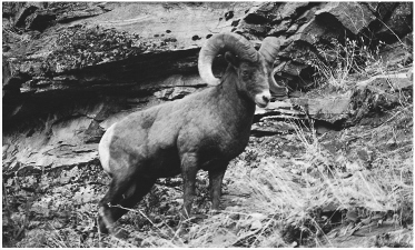
focus Bighorn Sheep
Vaseux Lake is famous for its herd of bighorn sheep. These spectacular animals are fairly easy to see from fall through spring, when they graze on the grasses above the highway. The older rams have massive curled horns that they display to each other and smash together in dominance contests; the females have shorter, thinner horns. Groups of bighorns formerly crossed the highway here to reach the lakeshore and hay fields at the south end of the lake, but the road mortality was so high that officials erected a high, wire fence to protect the sheep from vehicle collisions. About 450 sheep once roamed on the east side of the Okanagan Valley from Penticton south to Osoyoos, but in the winter of 1999–2000, a bacterial pneumonia epidemic swept through the herd and reduced the population to about 140. The disease was likely passed to the wild sheep by small domestic sheep herds in the area.
Happily, the bighorn population seems to be making a remarkable recovery and now numbers about three hundred. Small herds are often seen from the highway at Vaseux Lake. The females take to the rugged cliffs in May to give birth to their lambs in safety; at the same time, the adult males retreat into the hills to feed on fresh grass as it greens up at higher elevations in the summer. All of the sheep return to the lower grasslands in the fall, and mating takes place in November.