{ 10 }
APEX MOUNTAIN AND GREEN MOUNTAIN ROAD
33 km, all paved secondary road
This is the road to the main ski area in the south Okanagan; it begins in a shady creek valley, then snakes up through a variety of forest types to the subalpine. An optional route continues on to Highway 3 at Hedley, or you can retrace your steps to Penticton.
START: Intersection of Fairview Road and Channel Parkway (Highway 97) in Penticton; travel west over the bridge and on to Green Mountain Road.
YOU CAN SEE SHINGLE CREEK entering the Okanagan River just north of the bridge; Ellis Creek enters the river behind you on the east side. The deltas of these two creeks provide much of the land that Penticton is built on. The road winds through the main village of the Penticton Indian Reserve for the first 2 kilometres. According to local elders, the main Native village in this part of the valley used to be located at Vaseux Lake, but after the population was devastated by disease with the arrival of Europeans, the remaining families joined people already living at Penticton.
To the north you can see a good stand of old cottonwoods; these trees are one of the last remnants of a major wetland that covered the northwest corner of Penticton before the Okanagan River was channelized in the 1950s. The river used to meander through the western part of Penticton, first through a large marsh at the north end, then through rich riparian woodlands of cottonwood and water birch. After the river was confined to the channel dykes, most of the wetland was filled for housing developments, and the cut-off river bends, or oxbows, lost much of their adjacent woodlands. The cottonwoods have been home to a colony of great blue herons since 2008, but the large, stick nests are difficult to see from the road.
To the south you can see a long, grassy ridge with a lot of small pine trees on its northern flanks. This ridge, and much of the mountain to the south, was burned in a fire in the early 1980s, and reseeding by ponderosa pine is very slow in this hot, dry environment. As you leave the village, the Shingle Creek valley begins to narrow, and you can see white silt hoodoos eroded out of the bench to the south and similar bluffs on the north side. These are composed of glaciolacustrine silts, a term used for the fine glacial flour deposited into lake bottoms. They formed at the end of the Pleistocene Epoch about 12,000 years ago, when ice sheets on the plateau were melting, sending silt, sand, and gravel into the large glacial lake at Penticton.
The valley narrows even further, the creek hemmed in by rock walls at several places. At one point there is a pink-orange cliff on the south side of the road, with obvious, large crystals embedded in it. These crystals are feldspar and quartz in volcanic and igneous rocks formed about 52 million years ago, when the valley was splitting open and molten rocks flowed to the surface.
The creek flows swiftly past these cliffs, and with some luck you might spot an American dipper bobbing on the rocks. These songbirds look like grey tennis balls doing knee-bends as they match the water flow with their jerky movements. Dippers forage underwater for insect larvae, swimming against the current with their stubby wings. With even more luck, you might see harlequin ducks here in the spring. These ducks spend most of the year in the Pacific surf along the British Columbia coast but fly to creeks and rivers in the Interior in April and May to nest. The males are spectacular in slate-blue plumage marked with bright white and chestnut stripes; the females are a dark brown, with two white smudges on their cheeks that only make them more difficult to see as they swim along the dark shores of the creek. British Columbia is home to a good percentage of the world’s harlequin duck population, but few nests have been found here. The females tuck themselves away in root tangles along the streambank, and only the luckiest naturalists have discovered the down-covered eggs. Interestingly, two of the earliest harlequin duck nests discovered in western North America were found by anglers fishing along Shingle Creek.
The Shingle Creek valley is an oasis of moist, cool forests in a hot region. As you cross the first bridge over the creek, you’ll see the red stems of red-osier dogwood shrubs under the trees, a species typical of creeksides and other wet areas. Unlike other dogwoods, it doesn’t have showy flower clusters framed in large white bracts but instead has sprays of small white flowers that produce cream-coloured berries much favoured by birds.
Another plant that requires a high water table is the western redcedar; you can see a few of these elegant trees scattered along the creek. There used to be many more large redcedars here; indeed, the creek gets its name from the shingles cut from the big trees felled in the early 1900s.
The shady south side of the valley is cloaked in Douglas-fir, many of the trees bearing large masses of twiggy witches’ brooms. These growths are caused by the attack of dwarf mistletoe, a tiny parasite that attaches itself to the branches and, in doing so, stimulates the rapid growth of small branches. The energy the tree puts into the witches’ brooms does slow its growth, but the clumps provide ideal cover for roosting birds, and owls and hawks will even nest on large, thick clumps.
The deciduous woodlands along the creek attract a tremendous diversity of plants and animals, all drawn by the promise of water, cool shade, and abundant food. Summer mornings ring with the exquisite song of the veery; the spiralling cascade of notes perfectly fits the streamside location. The veery is one of three species of drab little thrushes in this region whose voice easily trumps its looks. You might hear the other two—Swainson’s and hermit thrushes—higher up on this road. Many large cottonwoods still grow along Shingle Creek, and some of them show the hollow, rotten cores so valued by mammals and birds for home sites. One of the species restricted to this habitat in the British Columbia Interior is the Vaux’s swift, the western equivalent of the chimney swift.
Just past the second bridge crossing the creek, the valley opens to a broad, wet meadow. The creek can meander more across the flats, and beavers often choose this spot to dam the stream to deepen the water for their winter navigation needs. Cattails form a lush marsh along one of the old streambeds, and sandbar willows create a thicket nearby. The meadow is used for wintering cattle, and bald eagles gather here in February, during calving season, to feed on the afterbirths. These fields also attract coyotes, which lope through the grass listening for mice. Across the field you can see a big bank swallow colony—a cluster of holes dug into a silt bank.
The Shingle Creek valley swings north at this point, and the road leaves it, turning south up the Shatford Creek valley. After winding past some hay fields, the road crosses the creek and angles westward again to follow the valley. A large volcanic bluff, called Hedges Butte, is prominent to the south. This valley was the old stagecoach route out of Penticton in the late 1800s and early 1900s. Passengers bound for Keremeos and the Hedley gold mines would rest near here at Allen Grove, the first stop on the trip out of Penticton. The hills to the south are heavily cloaked in Douglasfir, and if you stop here on a summer morning, you might hear the songs of Swainson’s thrushes coming from the cool forests, spiralling upwards instead of down like that of the veery.
You soon reach the junction of Green Mountain Road and Apex Mountain Road. You can follow the former to the left, which will take you out to Highway 3A just north of Keremeos, but we will turn right on to Apex Road, following the route of Shatford Creek as it tumbles off the mountain. The road climbs steeply along the north side of the creek through open Douglas-fir forests. Across the creek, the shady north-facing slopes take on a more subalpine character, with Engelmann spruce becoming common, and eventually you are surrounded by this cool, fragrant forest. Spire-like subalpine firs mix with the straight, thin trunks of lodgepole pine, and if you stop to listen, you might hear the high, buzzy songs of Townsend’s warblers coming from the treetops in summer. This is also the domain of the hermit thrush, the third member of the trio of masterful singing thrushes. The song of the hermit thrush is the most ethereal of the three, always beginning with a high, pure note, then slipping up or down the scale.
Just before you reach the ski village, you drive through Rock Oven Pass at about 1,760 metres elevation. If you stop and listen here, you might hear the nasal enk! of a pika calling from the talus slopes below the road. Pikas are common denizens of the rocky talus slopes at Rock Oven Pass. They are relatives of rabbits and hares but lack the long ears and big hind feet. They spend their summers gathering grass and flowers, curing their harvest in hay piles on sunny rocks, then storing it underground for winter consumption. The jumbled rocks provide easy cover from predators such as hawks and an ample choice of underground accommodation for a cozy winter nest.
The closest relatives of these small “rock rabbits” at this elevation are snowshoe hares, which are, in many ways, the keystone species in this ecosystem. The hares go through ten-year population cycles; at the peak of each cycle, you can see them constantly as you drive along, bounding across the road into the forest. But their predators—great horned owls, northern goshawks, and lynx are the most important—soon catch up with them. The predators raise so many healthy young while the hares are abundant that within two years the hunters literally eat all the hares they can find, and the population declines to the point where it’s hard to find a hare anywhere. The predators then turn their attentions to grouse, squirrels, and other prey, allowing the hares to slowly recover in numbers.
When you reach the ski village, you can see the high subalpine ridge of Beaconsfield Mountain to the south and west. This is the hill with the ski runs; the true alpine tundra of Apex Mountain is just out of sight to the south. Any time of year, the most conspicuous birds around the village are members of the crow and jay family. Grey jays, also known as Canada jays or whisky jacks, float among the trees, looking for a well-stocked bird feeder or a skier having lunch. They are often joined by bright blue Steller’s jays. Jays have a high degree of intelligence, an important characteristic for year-round survival at this elevation. They spend the summer and fall storing food for winter use, which explains how they ate your lunch so quickly—it’s all been tucked away in a tree somewhere. Another common member of this family is the Clark’s nutcracker, which looks superficially like a grey jay but has black-and-white wings and a long, woodpecker-like beak. Nutcrackers specialize in storing pine seeds for winter and spring consumption, but they won’t turn their noses up at peanuts, either. The largest member of the crow family in the mountains is the common raven. These big birds look for larger scraps—the carrion left by lynx and cougar usually gets them through the winter—but these days they forage a lot in garbage dumps.
The ski village marks the end of the paved road, but you can continue on the Nickel Plate Road if you wish. This gravel road crosses the plateau to the Mascot Mine, then drops in spectacular fashion into the Similkameen Valley, reaching Highway 3 just south of Hedley. Take this road as well if you’d like to hike up Apex Mountain itself; the four-wheel-drive trail starts at the sharp bend just east of the Nickel Plate Cross-Country Ski Area. It is about an 8-kilometre walk to the top of the mountain, a great destination on a hot summer day.
black swift
focus Swifts
Vaux’s swifts nest and roost in hollow trees, and cottonwoods are their favourites. Their eastern cousins, chimney swifts, nest in large chimneys, a habit they picked up quickly after the old-growth forests of eastern North America were liquidated during European settlement. Chimney swift populations have declined drastically in the last few decades as usable chimneys disappear from the landscape. Fears of a similar fate have been expressed about Vaux’s swifts, since the big, hollow trees they need are becoming rarer each year.
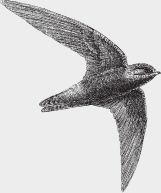
Swifts are small, cigar-shaped birds with swept-back wings. They twinkle through the air while their open mouths scoop up small insects. Their closest relatives are the hummingbirds; both groups have legs that are too small for walking or hopping. The other characteristic that ties them together is wing structure. In most birds the main flight feathers are attached to the ulna, or forearm; the feathers attached to the hand of the wing are used for propulsion. In hummingbirds and swifts, the ulna is so short that the feathers attached to it play little role in flight, but the feathers attached to the hand of the wing are used for both propulsion and lift. This structure allows hummingbirds to hover and gives swifts their distinctive twinkling flight pattern.
There are two other species of swifts in the Okanagan Valley. The all-dark black swift is the largest; it nests on rocky ledges beside mountain waterfalls and forages for flying ants over mountain peaks. The white-throated swift nests in deep crevices on the dry, rocky cliffs throughout the valley.