{ 13 }
PENTICTON TO WEST BANK

43 km, all paved highway3

This is another scenic section of Highway 97, a necessary route if you are travelling from Penticton to Kelowna. It provides magnificent views of Okanagan Lake and has a few hidden surprises.

START: Okanagan River bridge on Highway 97, at the north end of Penticton.

HIGHWAY 97 CROSSES the Okanagan River, which was channelized in the 1950s to regulate and expedite high water flows in spring and summer. The first bridge here was located a few hundred metres north—right at the river outlet on the lake—because the whole northwestern quadrant of Penticton was a large marsh complex that the river lazily meandered through. Most of the marsh was drained when the river was channelized; the last remnant was filled in the 1980s to create a gated community, ironically named Redwing Estates after the red-winged blackbirds that had nested in the marsh.

The road travels along the lakeshore all the way to Summerland. Spectacular white bluffs, created in the closing centuries of the Pleistocene epoch about 12,000 years ago, tower above you on the west side. The present site of Okanagan Lake was at that time a huge glacier, flanked on either side by a long lake fed by melt-waters. The lake—Glacial Lake Penticton—was dammed by an ice plug at McIntyre Bluff, north of Oliver.

Like all glacial lakes, Lake Penticton was an ethereal sky-blue colour, tinted by the fine silts suspended in its waters. These silts were the glacial flour produced over centuries of glaciers scouring bedrock. Every spring brought a new load of silt into the lake, which slowly settled to cover the bottom with a thick layer of white mud. By the time the glacier had completely melted, the mud was many metres deep, and when the ice plug disappeared, allowing Lake Penticton to drain, the silt deposits were left high and dry as the cliffs you see today. If you look closely, you can see the annual layers, called varves, laid down in the silt deposits.

You can always see a few waterfowl along this stretch of the lake, especially in winter. Watch for flocks of American coots from October through April; these rather comical-looking birds are completely grey and black except for a bright white beak. Although they act like ducks, diving in search of underwater plants, they are actually related to rails and cranes and have lobed toes instead of webbed feet like ducks. Coots are the favourite winter food of bald eagles here, so look for these big raptors perched watchfully in the large trees along the road. If an eagle is actively hunting the area, the coot flocks will bunch up into solid masses, each coot hoping not to get singled out by the eagle.

About 7 kilometres north of Penticton, the highway reaches the delta of Trout Creek. Sandy beaches stretch along sheltered bays of the point, one of them accessible through Sun-Oka Provincial Park. The park also preserves a stand of old cottonwood trees. Their large trunks, many of them partly hollow, provide home sites for many animals. One of the characteristic species in this habitat is the Lewis’s woodpecker. These are unusual birds; although they excavate a cavity in a tree for a nest site like good woodpeckers, they forage primarily by either flying around in the air like swallows, catching insects on the wing, or by gobbling berries, fruit, or nuts from nearby shrubs and trees. They look like small crows in their glossy black plumage, set off by a bright pink underside. Another good place to watch for Lewis’s woodpeckers is on the grassy hillsides along the highway north of Summerland.

The highway crosses Trout Creek on a small bridge. With its streamside trees removed and its banks diked to prevent flooding, Trout Creek is a rather lifeless version of its old self. Its unshaded waters are often too warm for trout survival, and so much of its flow is diverted for human use that there is usually only a trickle left in late summer. As you round Trout Creek Point and return northwest to the lakeshore, the rocky bluff of Giant’s Head dominates the western horizon. This is a volcanic core left over from the fiery birth of the Okanagan Valley about 55 million years ago. Volcanic activity was common throughout the valley as the bedrock on the west side shifted to the west, cracking open the valley along a long fault system.

After a short stretch along the lake, the road climbs a wide gulch up to the main townsite of Summerland. In the early days of the town, this upper settlement was called West Summerland, and the centre of activity was along the lakeshore northeast of the highway. The highway leaves Summerland through a large, rocky gap at the north end of town; these are more volcanic rocks similar to those that make up Giant’s Head. The highway continues north, hugging the base of these bluffs (and blasted through them in several places). Golden eagles make their nests in some years under the overhang near the top of one of the bluffs, the adults hunting for the yellow-bellied marmots that sun themselves on the rocky slopes. A small herd of mountain goats can sometimes be seen on the steep, grassy slopes about a kilometre north of town, where escape terrain is close at hand on the nearby cliffs. These slopes are also important winter range for mule deer; large numbers move off the high plateaus to lower elevations, attracted by the relatively shallow snowpack and abundance of food. One of their favourite food plants here is the red-stemmed ceanothus, a shrub that is particularly common after ground fires.

To the northeast you can see the rounded, rocky slopes of Okanagan Mountain, extending into the lake as Squally Point. On August 16, 2003, a lightning strike above Squally Point started one of the most destructive forest fires in Canadian history. Before it was finally put out in the cooler, damper days of late September, it had forced the evacuation of 45,000 people from their homes, burned 239 houses in Kelowna, and consumed 250 square kilometres of forest. Firestorms such as this one are becoming more common throughout western North America; a half-century of selective logging and aggressive fire suppression has created a forest structure and fuel load perfect for high-intensity fires. Native people throughout the West used to burn sections of their territories each spring and fall to maintain an open character to the forest, especially in dry woodlands such as those dominated by ponderosa pine and Douglas-fir. These fires kept fuel loads low and created ideal habitat for food plants such as arrowleaf balsamroot and bitterroot. Today, forest managers are once again looking at prescribed burns as a way to minimize the risk of midsummer wildfires.

After traversing the hillside well above Okanagan Lake for 14 kilometres, the highway drops to lake level at the south end of Peachland, onto the small delta of Peachland Creek. Loons, mergansers, and gulls often gather at the creek mouth in late summer and fall, since the creek is a major spawning ground for kokanee, the landlocked form of sockeye salmon. The creek itself is well worth a stop; turn left just south of the bridge and park. A lovely trail goes up the narrow valley, shaded by tall cottonwoods and cooled by the creek itself. The trail ends at Hardy Falls, where Peachland Creek pours over a small rocky cliff into the gorge. Watch for American dippers here; these small grey songbirds make their mossy nests in a rock crevice near the falls. You can often see them on creekside stones, bobbing up and down then diving abruptly underwater in search of insect larvae.

Continue along the lakeshore, then travel through the town of Peachland, crossing another major creek, Trepanier, before slowly climbing again. As you leave Peachland, the road climbs more steeply up Drought Hill (named after the Drought family, not a local climatic condition). This slope is a very important winter range for mule deer that live on the plateau west of Peachland. At the top of the hill, you pass two small ponds on the northwest side of the road—watch for painted turtles sunning themselves on logs, if you can see over the cement guardrails. Beyond the ponds is the Gorman Brothers sawmill—one of the major forestry companies in the region—followed by the town of Westbank.

2011-02-28T20-04-19-872_9781926812243_0128_001

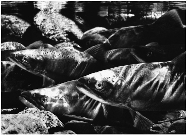
focus arrowr Kokanee

Kokanee are a type of sockeye salmon, and like their oceangoing cousins, they spend the first year of their lives in a lake, eating plankton. But kokanee stay in the lake for the rest of their lives, returning in their third or fourth year to the place where they were born to spawn and die. Some kokanee in Okanagan Lake spawn along gravelly shores, mostly across the lake from Peachland along the rocky headland of Okanagan Mountain Provincial Park. But most spawn in creeks up and down the valley. In 1966 fisheries biologists introduced mysid shrimp into Okanagan Lake, since they had noticed that mature kokanee in lakes with these large shrimp grew to record sizes. Unfortunately, they didn’t realize that the shrimp also compete with young kokanee for small plankton, and they effectively starved the small fish. In the early 1970s, kokanee numbers in Okanagan Lake began to plummet, going from over a million spawners to about ten thousand by 1998. The sportfishery was closed from 1995 to 2005, and a number of other conservation measures were put into place, including operating a shrimp trawler to reduce the mysid population. By 2007 the kokanee spawning population had rebounded to 296,000, and sportfishing has been reopened for short trial periods.