{ 14 }
WESTBANK AND CRYSTAL MOUNTAIN

24 km, all paved

This route takes you around Mount Boucherie and its cluster of wineries to the shore of Okanagan Lake, then back up into the high forests of Crystal Mountain Ski Area.

START: Junction of Highway 97 and Boucherie Road in Westside.

BOUCHERIE ROAD CLIMBS a low ridge, surrounded by a mix of pastures and rural housing developments. Mount Boucherie dominates the skyline to the southwest. Although it reaches an elevation of only about 760 metres now, Mount Boucherie was once an impressive volcano as high as any of the Okanagan mountains are today. It was active about 50 million years ago, when faulting opened up the Okanagan Valley. Mount Boucherie is considered a composite volcano, formed by many separate eruptions over a long time period. Early flows cooled to distinctive pale rocks; later flows created the dark dacite cliffs that are conspicuous today. Many of these dacite bluffs show the characteristic columnar formations that are created when lava cools slowly from the surface down. Shortly after Mount Boucherie formed, vast quantities of sediments were deposited around it, burying the base of the mountain in sandstones and conglomerate rocks. Millions of years of water and wind and several glaciations have ground it down to its present size.

Mount Boucherie is named after Isadore Boucherie, an early farmer in the Kelowna area who once owned a ranch at the base of the mountain. You can access hiking trails on the mountain through Eain Lamont Park; the park entrance is off Ogden Road about 2.5 kilometres from the highway.

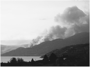
As Boucherie Road reaches the top of the ridge, you can see Okanagan Mountain to the southwest. Much of the forest on the mountain was burned in the catastrophic fire of August 2003. Patches of ponderosa pines remain at lower elevations, however, and in a decade or two the park will be a picturesque parkland of big pines and bunchgrass meadows.

On the south side of the ridge, vineyards become a common sight, and you begin to pass wineries—Mt. Boucherie Estate, Quails’ Gate, and Mission Hill Family Estate. Just past the entrance to Mission Hill, you can look down to the hill to the south and see the lagoon of Green Bay. The lagoon is formed by the wave-borne sediments carried north from the delta of McDougall Creek in southerly storms. Boucherie Road drops down to the delta of the creek. At the junction with Pritchard Road, you can see a prominent bluff of sedimentary rocks—sandstones and conglomerates—on the north side of the road. Just past the bluff the road crosses McDougall Creek and its rich riparian woodland. This creek has nesting pairs of western screech-owls along it—an endangered species that requires mature woodlands of cottonwoods and water birch, which grow only along creeks such as this.

West of the McDougall Creek delta, Boucherie Road ends at Gellatly Road, which comes downhill from the right. Continue along Gellatly Road as it hugs the shoreline of Okanagan Lake; within a kilometre it reaches the delta of Powers Creek. The beach at Powers Creek is a favourite loafing site for gulls during the winter. If you have a pair of binoculars, check them out and see how many species you can see. An adult gull (they take four years to reach maturity, and it is best to leave immatures unidentified if you’re just starting out in the birding world) can usually be identified by noting the colour of its legs, bill, and wings. Four kinds are common here: the ring-billed has yellow legs and a black ring around its bill; the California has yellow-green legs and a black-and-red spot on its bill; the herring has pink legs, a red dot on the bill, and black wingtips, and the glaucous-winged looks like a herring gull with grey wingtips.

Gellatly Road comes to a T-junction and turns right. Here you’ll find the Gellatly Nut Farm Regional Park. The Gellatly family homesteaded here in the late 1800s and, in the early 1900s, planted the first commercial nut farm in Canada, growing walnuts, hazelnuts, chestnuts, and other varieties.

Just past the nut farm site, the road crosses Powers Creek, with another healthy grove of old cottonwoods. Gellatly Road then climbs up the west side of the Powers Creek valley and passes through apple orchards before reaching Highway 97. Continue over the highway as our route turns into Glenrosa Road. The Gorman Brothers sawmill is to the west as Glenrosa begins climbing through a residential area, coming into scrubby ponderosa pine and Douglas-fir woodlands about 4 kilometres from the highway. Glenrosa Road levels out on a large flat with copses of trembling aspen and cottonwood, then turns sharply right and begins climbing again. Many of the trees in these aspen copses are clones—genetically identical copies of a single individual that pioneered the site many years ago. Aspens grow fast and die young but often reproduce from suckers sent up from the roots of a mature tree. This process forms a steadily enlarging clump of new trees, each an identical twin of the original. You can sometimes see the boundaries of these clones in the fall, when each clone turns colour at a slightly different time, producing a patchwork of green, yellow, and orange copses on the hillsides.

Many of the Douglas-firs on the hillside have large, dense clumps of twigs known as witches’ brooms. These are formed when the tree is attacked by a tiny parasite—the dwarf mistletoe. As the mistletoe sends its cells into the sapwood of the tree to steal sugars and other nutrients, it prompts a reaction in the Douglas-fir akin to a cancerous growth, causing the tree to produce this mass of twigs. Another freeloader on the firs is the bright yellow chartreuse lichen. As in all lichens, this combination of a fungus and alga simply uses the tree for support. The lichen gets all the nutrients and water it needs from the winter and spring rainfall.

Thimbleberries are common understory plants here, easily recognized by their large, soft, maple-like leaves. The size and texture of the leaves make them an ideal emergency source of toilet paper. The flowers are white, and the berries resemble large, flat raspberries. They are tasty if picked at the right moment but quickly turn soft. The forest changes quickly over the next few kilometres, with lodgepole pine becoming prominent within the mix of Douglasfir and ponderosa pine. The lodgepole pines have much shorter needles than the ponderosas, and their ramrod-straight trunks are grey-brown, unlike the glowing orange trunks of the ponderosa pines. Many of them have been recently killed by pine beetles.

Higher still, Engelmann spruce begin to show, identified by their long grey-green branches and flaky bark. You are now in an entirely different ecozone, dominated by the spruce and its close compadre, the subalpine fir. The firs have short, stiff branches and a spire-like shape, designed to shed the heavy snowfalls common in winter at these elevations. A mountain wetland appears on the right, ringed by cattails; listen here on summer mornings for the ringing witchity-witchity-witchity of the common yellowthroat. If you’re lucky enough to see this little warbler, you’ll recognize it immediately by its bright yellow breast and black Lone Ranger mask. Just past the wetland, the road ends at Crystal Mountain Ski Area.

focus arrowr Firestorms

The fire that raged across Okanagan Mountain in 2003 was what forest ecologists would term a classic high-intensity, stand-destroying fire. Started by a lightning strike on August 16, the fire quickly moved over the hillside, fanned by constant southerly winds. Thick stands of timber, dried through a long, hot summer, were destroyed as the inferno roared through the treetops. When the fire was finally put out by an army of firefighters and cool autumn rains in late September, it had consumed more than 250 square kilometres of forest and 239 homes on the southern edge of Kelowna. Although this was an extreme example, such fires have become more common in the last century, and not just because the climate is warming.

Evidence from tree rings and historical sources suggest that before the late 1800s, many of these dry forests were subjected to frequent, low-intensity fires set by indigenous people. Set in the cool days of autumn or spring, these fires burned low on the forest floor, killing small trees, shrubs, and dry grass but leaving large, live, older trees to create an open, park-like forest. Ponderosa pines and Douglas-firs are well adapted to these cooler fires; their thick bark protects them from ground fire, and the big trees actually benefit from the regular clearing of smaller plants that compete for water. The habitat created by these fires was ideal for the local people—food plants such as balsamroot, bitterroot, and spring beauty were more common; deer and elk grazed on the abundant grass; and villages were protected from more serious fires.

In the late 1800s, this practice of regularly burning the forest was abruptly stopped as the indigenous people were forced onto reserves and their culture was severely disrupted. Small trees and shrubs grew quickly, turning the open woodlands into thick forests, a pattern exacerbated by the selective logging of large trees and overt fire suppression in the 1900s. These small trees provide abundant fuel that can easily carry ground fires into the crowns of the large trees. Compounded by the climatic change to longer, hotter, drier summers, the scene is now set for more catastrophic firestorms.
2011-02-28T20-04-19-872_9781926812243_0135_001

Okanagan Mountain fire, August 2003

Prescribed burns are being set more frequently by forest managers to alleviate the problem, but in many areas there is simply too much fuel in the forests to safely do this. Careful removal of lower branches, small trees, and shrubs must be done mechanically before fire can be used to complete the job. These projects can be expensive, but they cost only a fraction of the amount spent on fighting a major forest fire. Public concerns about air quality during prescribed burns and fears about runaway fires must also be addressed, but the greater fear of seeing whole communities razed by wildfire may allow land managers to reintroduce fire as an important ecological tool, as indigenous fire-keepers have done for centuries.