{ 16 }
GLENMORE AND BEAVER LAKE ROAD

29 km, all but 4 km paved

This route combines two back roads that tour the hills north of Kelowna, ending in the subalpine forests high above the valley.

START: Spall Road at Highway 97, Kelowna.

DRIVE NORTH ON SPALL ROAD, continuing past Bernard Avenue and on to Glenmore Road. The Glenmore Valley lies between two volcanic ridges—Knox Mountain on the west and Dilworth Mountain on the east. Like almost all the volcanic structures in the Okanagan, these two mountains were formed about 50 million years ago just after the Okanagan Valley cracked open along the Okanagan fault. In the 1900s the Glenmore Valley was a pastoral area, but it is now being converted into a collection of suburban neighbourhoods as Kelowna rapidly expands in all directions. About 3 kilometres from the highway, Glenmore Road skirts the eastern slopes of the Knox Mountain ridge, the hills covered in an open woodland of ponderosa pine and Douglas-fir.

Eventually you leave the suburban developments behind and enter a more rural landscape. Extensive alfalfa fields lie on the east side of the road, then you crest a hill to see the vast Glenmore Landfill. This landfill was created in the mid-1960s on the site of one of the richest marshes in the Okanagan Valley. When I was a boy in the late 1950s and early 1960s, our family would often visit this marsh to revel in its bird life. We called it Schleppe’s Slough, but its official name was Alki Lake. As the official name suggests, this was a large alkaline marsh with no outlet. Its bulrushes were filled with the raucous calls of yellow-headed blackbirds and colonies of eared grebes. Wilson’s phalaropes flew over the muddy shores, and the water was covered in ducks. Today the lake consists of a few remnant salty puddles along the south end of the landfill, and plans indicate that these will eventually be filled in as well. The landfill attracts hundreds of gulls daily; in the summer many of these are breeding birds from the Grant Island colony at Carrs Landing (section 18). The deep pond along the roadside often has interesting ducks, especially during spring and fall migration, but the real birding attraction at the landfill today is the number of avocets that nest here.

North of the landfill, Glenmore Road climbs into low hills covered by young ponderosa pines. Small Douglas-firs are common in the understory, suggesting that this forest will eventually become dominated by Douglas-firs if fire or some other disturbance does not intervene. These dense, dry forests are one of the results of fire suppression but, paradoxically, are a great fire hazard themselves. If a fire starts in this type of forest on a hot, windy summer day, the small Douglas-firs will quickly carry it into the pines, possibly creating a firestorm that will spread rapidly and catastrophically. Forest managers are trying to thin many forests of this kind, especially around urban interfaces, so that any fires that start will remain on the ground, spread more slowly, and be easier to extinguish. Indigenous peoples lit fires each autumn in pine forests on a regular cycle to clear out the understory, producing more food plants in the forest, maintaining good habitat for game animals, and reducing the chance of dangerous fires around their villages.

The road passes two small alkaline ponds over the next few kilometres; both attract nesting ducks, coots, and blackbirds, and their warm waters are home to a diverse insect population. Past the ponds, the road winds through rural acreages then enters the orchards of Lake Country. Keep right at the junction and you will reach Highway 97; cross the highway and continue east on Beaver Lake Road. This road crosses the valley bottom through residential and industrial properties, then begins to climb a grassy hillside to the east. The grasslands here are heavily infested with alien invasive plants, also known as weeds. Cheatgrass, a low annual grass native to Europe, is abundant here, as is mustard. The more shrubby plants, such as rabbitbrush and smooth sumac, are native. In some areas sand dropseed dominates the grass community— this native annual grass can be common in disturbed areas.

Bluebird nest boxes line this road—both western and mountain bluebirds nest in the area. The male western has a purplish-blue body and rust-coloured breast; the mountain male is sky-blue all over. Other birds use the boxes as well. Metallic-blue-and-white tree swallows are common, and house wrens have filled some boxes with small sticks. One of the prettiest birds along the road is the lazuli bunting. The male looks superficially like a bluebird— iridescent blue above with an orange breast—but its white belly, white wing bars, and thicker bill set it apart from the bluebirds. Male buntings sing from saskatoons and other large shrubs while the drab female sits on the nest tucked into thick rosebushes.

About 6 kilometres from the highway, the road drops into a small valley. The grassland disappears abruptly, replaced by willow, birch, and even western redcedar, all species of very moist forests. A couple of kilometres farther on, the road crosses a cattle guard and turns into a well-maintained gravel road. The forest slowly changes to a subalpine forest as you gain altitude, with Engelmann spruce and lodgepole pines appearing a kilometre past the cattle guard. The spruce have long, drooping branches and flaky bark, whereas the pines have ramrod-straight trunks.

If you look closely at the spruce branches, you may notice that some of them have small, cone-like growths at the tips. These structures are galls, the abandoned homes of the Cooley gall aphid, and if you look really closely, you’ll see that the scales are actually swollen, dried needles. A female aphid lays her eggs on the soft, new twig, and as the young aphids suck juices from the stem, they exude chemicals that stimulate the growth of the gall, forming a home around them. The young aphids mature into winged adults and fly off to found a new generation of woolly aphids on Douglasfir trees. This generation produces no galls, but the cycle completes when the progeny of those aphids return to the spruce forests.

A little farther along, you will see the other distinctive tree of these high forests, the subalpine fir. Its spire-like shape helps it shed the deep snows that fall here in winter. You then reach Swal-well Lake (also known as Beaver Lake).

2011-02-28T20-04-19-872_9781926812243_0148_001

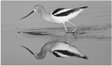
focus arrowr American Avocet

Avocets are remarkable shorebirds in many ways. They are striking and conspicuous in contrasting black-and-white plumage, legs like sky-blue stilts, and heads the colour of soft rust. But their truly distinctive feature is a long, up-curved bill. The shape of the bill fits exactly with their feeding technique—they wade through shallow water, sweeping their bills back and forth, searching for invertebrates such as brine shrimp. The recurved shape of the bill allows them to have more bill in the water at any one time, and therefore a better chance at finding a tasty morsel with each sweep. They make their homes on the ground near the shoreline, creating a nest of dried mud that they can build up if water levels should rise.

Avocets are birds of alkaline prairie sloughs and were considered casual breeding birds in British Columbia until 1987, when two pairs nested on Alki Lake. The population grew so that by 1997 nineteen pairs nested there. The number fluctuates from year to year depending on water levels in the local area as well as in the centre of the species’ range. The City of Kelowna plans to construct a separate shallow lake outside the landfill to mitigate the eventual loss of Alki Lake from landfill expansion—it will be interesting to see if the complex set of conditions needed to attract the avocets can be recreated in the new setting.