
Wallaman Falls Near Ingham, Girringun National Park
PARK INFORMATION
NPRSR 13 7468
SIZE
208 550 ha
VISITOR INFORMATION
Ingham (07) 4776 4792 | Cardwell (07) 4066 8601 | www.tyto.com.au
LOCATION AND ACCESS
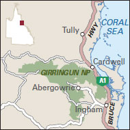
51 km west of Ingham (Wallaman Falls section), 75 km south-west of Ingham (Mt Fox section) or 25 km north-west of Ingham (Dalrymple Gap track) via Abergowrie Rd and Trebonne (4WD only in wet weather); 80 km west of Kennedy (Blencoe Falls section) via Kirrama Range Rd (4WD only)
CAMPING
Campsites in Wallaman Falls and Blencoe Falls sections only; permit and fees apply

Girringun National Park, part of the traditional lands of the Warrgamaygan people, comprises four sections: Blencoe Falls, Dalrymple Gap, Mount Fox and Wallaman Falls in the Herbert River Valley, which is the most accessible. Here the Wallaman Falls plunge 300 metres off the Seaview Range, the longest single-drop waterfall in Australia. The gorge supports rainforest with palms, umbrella trees and figs, while around the rim grow casuarinas, eucalypts and grasstrees. At Mount Fox, a dormant volcanic crater, the windswept, rocky landscape allows only small patches of vine-thicket rainforest to persist around the rim. Metre-wide rocks called fusiform bombs lie around the crater rim, a legacy of past eruptions. Access to Blencoe Falls is difficult and 4WD only. Dalrymple Gap’s sole attraction is the walking track of the same name (10 km one way, 6 hours, difficult).
The Herbert River is home to platypus, eastern water dragons and saw-shelled turtles. Birds such as the crimson rosella, golden whistler and Lewin’s honeyeater can be seen near the campground, and spotlighting at night might reveal brushtail possums, sugar gliders, red-legged pademelons and bandicoots. The vine-thicket rainforest at Mount Fox is a crucial habitat for the vulnerable Sharman’s rock-wallaby.
There are many walking trails, ranging from strolls to sections of the Wet Tropics Great Walk, a network of connected trails (3–4 days). It is possible to climb the 815-metre Mount Fox (2 km return, 1–1.5 hours, difficult) and peer over the edge of the crater; but the path is unmarked and suitable for experienced bushwalkers only. Never swim, canoe, clean fish or prepare food at the water’s edge, or camp close to deep waterholes, as estuarine crocodiles live here.