Settlement of the Transjordan Tribes (32:1–42)
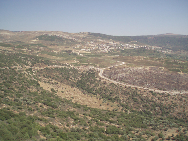
Lands of Jazer and Gilead (32:1). Having journeyed through the more arid regions south of the Arnon (such as Edom and Moab), the Gadites and Reubenites observe how the more northern region of Gilead is more fertile with highland grassy regions for grazing, and with valleys and hillsides suitable for grain and fruit orchards. Gilead extended through the Transjordan highlands from the Bashan and Golan regions in the north to the Jabbok River in the south, rising to more than 4,000 feet in elevation. Rivers such as the Yarmuk, Jabesh, Jabbok, and their tributaries, as well as the numerous springs in the region, provide ample water supply for humans and animals alike.
Gilead is perhaps glʿd mentioned in the texts from Ugarit,290 and ga-alʿa[a]-(za) of Akkadian texts of Tiglath-pileser III, a possible reference to Ramoth Gilead bordered on the north by the Aramaeans.291 The land of Jazer is an arable region northwest of Amman, generally associated with the area around Khirbet Jazzir, located about ten miles west-northwest of Amman and twelve miles south of the Jabbok.
Region of Gilead
Peter White
Ataroth, Dibon, Jazer, Nimrah, Heshbon, Elealeh, Sebam, Nebo and Beon (32:3). These cities are located in the arable highland plains of Transjordan on the east side of the Dead Sea, advantageous for farming, grazing, and animal husbandry.
Ataroth is identified with Khirbet ʿAttarus, located between Machaerus and Libb, just over ten miles northwest of Dibon. Ataroth and Dibon are cited in the Mesha Stele (ca. 830 B.C.) as a land and a town formerly occupied by Gad (l. 11–12).292
Dibon (modern Dhiban) was the Moabite capital, located about 3.3 miles north of the Arnon River gorge and twelve miles east of the Dead Sea.293 Jazer is cited above.
Nimrah is identified with Tel Beleibel just north northeast of Tel Nimrin, a Roman-Byzantine site that retains the ancient name. Note Beth Nimrah in verse 36 and the “waters of Nimrim” in Isaiah 15:6 and Jeremiah 48:34.
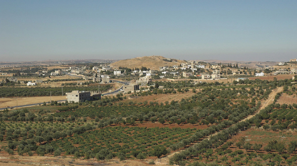
Heshbon is associated with Tel Hesban, about twelve miles southwest of Amman, Jordan (see comment on 21:23).
Elealeh is identified with Tel el-ʿAl, about two miles northeast of Heshbon.
Sebam is generally identified with Khirbet Carn el-Kibsh, between Heshbon and Mount Nebo.
Nebo (Kh. El-Mukhayyit) is located just south of its mountain namesake in the Abarim range of Moab; the Mesha Stele suggests a cultic center was dedicated to Yahweh there (l. 14–19).
Beon is identified with Maʿin, four miles southwest of Madaba; it seems to be the conflation of Baal Meon in verse 38.294
Tell Hesban from north
Todd Bolen/www.BiblePlaces.com
If we have found favor (32:5). After the list of the cities conquered from the Amorites and an acclamation that Yahweh their God was responsible for granting them the victory, the Israelites make a request of Moses and Israel’s other leaders. A similar entreaty for a land grant in proper protocol format is found in diplomatic correspondence of the ancient Near East, including the basic letter-writing language found in the Lachish, Arad, and Samaritan ostraca.295
Pens (32:16) The “pens” (gidrōt ṣ ʾ ōn—“stone pens for sheep” or simply “sheepfolds”) are perhaps the V-shaped stone enclosures found in Transjordan and the Arabah for protecting sheep, goats, and cattle during times of danger.296
If you will do this (32:20). The compromise proposed by the Gadites and Reubenites is structured as a covenant with stipulations in the formula of blessing and curse: “If you do X, then you will have Y blessing; but if you do not do X, then Z curse will come to you.” The covenant between the Gad and Reuben tribes and the other ten tribes has Moses as the mediator and Yahweh as the witness and guarantor of the commitment made by the two tribes.297
Gadites (32:33). The Gadites are allocated land grants in the southern part of the former kingdom of Sihon of the Amorites, most of which are cited in verse 3. Gad shares its northern border with the half-tribe of Manasseh. The cities listed for Gad in the Old Testament suggest a narrow strip of land in the Jordan River plain extending from the Jabbok River to the Sea of Galilee. Aroer (mod. ʿAraʿir) was located on the King’s Highway, just north of the Arnon. The Gadite cities are detailed in Joshua 13:24–28.298
Reubenites (32:33). These people receive the area and cities generally allocated south of those belonging to Gad. Among the cities are Heshbon, the former capital of Sihon’s Amorite kingdom, Elealeh, Kiriathaim (“twin cities”?), Nebo, and Baal Meon (see also Josh. 13:15–23).299 Simons identifies Kiriathaim with Khirbet el-Qureiyat, six miles northwest of Dibon, though Aharoni’s suggestion of Khirbet el-Mekhaiyet, northwest of Madaba, seems more likely.300
The half-tribe of Manasseh (32:33). The allocation to the half-tribe of Manasseh is generally north of Gad, extending from the region of Gilead into Bashan and the Golan. Only the cities of Havoth Jair and Kenath Nobah are mentioned here (but see Josh. 13:29–32).301