Boundaries of the Promised Land (34:1–15)
Canaan (34:2). Canaan was a definable geographical entity in Egyptian onomastica as early as the fifteenth century B.C., since Egypt controlled much of Canaan (Retenu) during the Eighteenth and Nineteenth Dynasties.313 Though the detailed borders are not as explicitly demarcated in the Egyptian records of the Late Bronze and Early Iron Ages, the cities and towns listed in both sets of documents encompass substantially the same region.
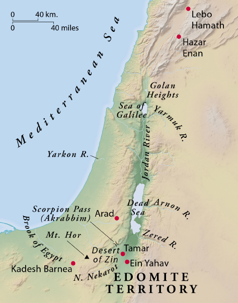
Territorial Boundaries of the Land
Southern side (34:3). The southern boundary begins with the Desert of Zin, from which the original scouts were sent (ch. 13), and extends first east northeast to the southern end of the Dead Sea (Salt Sea), avoiding Edomite territory (on the west side of the Arabah). The boundary then moves westward from the Desert of Zin, gradually turning more northwest toward the Great Sea, the Mediterranean.
Though many confine the Edomites to the east side of the Arabah, the geographical patterns here and in 20:14—21:12 (see comments) suggest otherwise. The Edomites occupied the hilly region south of the Nahal Zin, southwest and west of Ein Khatseva and Ein Yahav, and in the basin of the Nahal Nekarot. In fact, the Edomites are now known to have moved even further northwest into the area just south of Arad in the Israelite kingdom period.314
Scorpion Pass . . . Kadesh Barnea (34:4). The southern border passes just south of the famous “Scorpion Pass,”315 a winding road from the Nahal Zin basin into the Negev south of Mampsis.316 On Kadesh Barnea, see comments on 13:26. The border continues on to Hazar Addar and Azmon (cf. Josh. 15:3, the southern border of Judah); the locations of these two towns are unknown, though they probably lie along a natural geographical and topographical line between Kadesh Barnea and the Brook of Egypt (Wadi el-ʿArish). Aharoni identifies Hazar Addar with Ain Qedeis, Azmon with Ain Muweilih, and Karka of Joshua 15:3 with Qetseimeh.317 These three sites lie along the watershed between the Wadi el-ʿArish and the smaller Nahal Zin basin.
Western boundary (34:6). The natural western boundary is the Great Sea (i.e., the Mediterranean). A stormy body of water in the fall, winter, and early parts of spring, and often unpredictable even in the summer, all ancient peoples respected it. In Ugaritic mythology the sea was believed to be the abode of an often malevolent deity Yammu and his associate, the great sea serpent Lotan (Leviathan of the Old Testament). The western border extends along the shoreline from the Brook of Egypt in the south to a point west of Mount Hor and Lebo Hamath. These coastal plain regions were occupied by the Philistines (south of the Yarkon River) and various Sea Peoples and Phoenicians during the Iron I and Iron II periods; they were under Israelite control only briefly during the reigns of David and Solomon.318
Northern boundary (34:7). The northern boundary extends on a line from the Great Sea toward Mount Hor, which is likely one of the Lebanon mountain peaks just north of Byblos (perhaps Jebel Akkar).319 The northern border town of Hethlon (Ezek. 47:15) is identified with modern Heitela on the lower slope of Jebel Akkar.
Lebo Hamath (“the entrance to Hamath”), perhaps so named because of its geographical location as a southern access route to the city state of Hamath, is generally identified with modern Lebweh near one of the sources of the Orontes River. It was the northern border of Israel during the monarchy of David and Solomon (1 Kings 8:65). Joshua 13:4 contains the additional site of Aphek, identified with modern Afqa, about fifteen miles east of Byblos.
Zedad is associated with the modern town of Tsada (Tsadad), about thirty-five miles northeast of Lebweh; Ziphron remains unknown. Milgrom suggests that Ziphron and Hazar Enan be identified with two oases east of Zedad, namely Hawwarin320 and Qaryatein. Ezekiel 47:17 places Hazar Enan on the northwest border of the territory of Damascus.
Eastern boundary (34:10). The eastern border of the Israelite inheritance begins at Hazar Enan, where the northern boundary leaves off (v. 9). The border continues toward Shepham, south toward Riblah, around the east side of Ain, and on to the eastern edge of the Sea of Galilee (“Sea of Chinnereth”). Shepham is unknown; Riblah here is not the Riblah on the Orontes mentioned in 2 Kings 25:6. The LXX has “Arbela,” a mountain and town of that name on the prominent escarpment on the west side of the Sea of Galilee. Ain (“spring”) could be one of the springs that serve as the sources of the Jordan (i.e., the springs at Iyyon [Ijon]321 near Tel ed-Dibbin, at the base of Tel Dan, or at Banias [Caesarea Philippi in the New Testament]).
The border then follows the eastern side of the Upper Jordan Valley, descending toward the Sea of Galilee, including the strip of land on the eastern side up to the slopes of the ridge that extends from Caesarea Philippi southward along the western edge of the Golan Heights to the Yarmuk River. The sea was originally named Chinnereth, presumably because the lake looked like a harp from distant vistas such as Mount Arbel. From that sea the eastern border then follows the Jordan down to the Dead Sea, about sixty miles, though the river itself meanders back and forth for about eighty-five miles.
All these borders reflect the ideal territorial limits for the land of Israel, but they were not fully realized until the time David and Solomon (2 Sam. 8:1–18; 10:1–19; 2 Chron. 18:1—20:3).