16 FULLERSBURG WOODS FOREST PRESERVE LOOP
KEY AT-A-GLANCE INFORMATION
LENGTH: 3.25 miles
CONFIGURATION: Loop that includes a couple of short loops
DIFFICULTY: Easy
SCENERY: Salt Creek, woodland, marshes, islands, footbridges, and a mill that is now a museum
EXPOSURE: More exposed than shaded
SURFACE: Crushed gravel
HIKING TIME: 2 hours, including a visit to the Graue Mill
DRIVING DISTANCE: 21 miles from Millennium Park, downtown Chicago
ACCESS: 1 hour after sunrise to 1 hour after sunset
WHEELCHAIR ACCESS: Yes
FACILITIES: Visitor center, restrooms, water, benches, numerous log picnic shelters along the trail
MAPS: Maps available outside the visitor center and on the DuPage County Forest Preserve website, dupageforest.com; USGS topo Hinsdale, IL
SPECIAL COMMENTS: The visitor center is open 9 a.m.–5 p.m., except major holidays, and can be reached at (630) 850-8110. The mill is open mid-April to mid-November, Tuesday–Sunday, 10 a.m.–4:30 p.m. Admission to the mill is $3.50 for adults. Call (630) 655-2090 or visit grauemill.org for more information.
GPS TRAILHEAD COORDINATES
Latitude 422583
Longitude 4630735
Directions
From Chicago, take I-290 west to I-88. Follow I-88 for 3.5 miles until reaching IL 83 (Kingery Highway). Follow IL 83 south 0.8 mile. Turn left (east) on 31st Street and travel 0.5 mile until turning right (south) on Spring Road. Turn left 0.6 mile ahead at the sign for Fullersburg Park. The visitor center is at the north end of the parking lot.

IN BRIEF
You may be surprised to find this much natural beauty just 20 miles from the Loop. Nearly this entire hike accompanies Salt Creek as it meanders next to a bluff and winds around a couple of islands on its way to the historic watermill at the south tip of the park.
DESCRIPTION
Nestled against the communities of Hinsdale, La Grange, and Oak Brook, the 222 acres of Fullersburg Woods Forest Preserve have been a popular spot since opening to the public in 1920. While visitors have always been drawn to the creek and its environs, more recently the historic mill and visitor center have served as added attractions. When you pick up a map at the door of the visitor center, be sure to duck inside to see the 13,000-year-old wooly mammoth skeleton. The skeleton was uncovered in 1977 at Blackwell Forest Preserve, about 15 miles west of Fullersburg. The accompanying signs describe how researchers determined the animal’s age at death and gender and why researchers disagree about whether the mammoth was killed by humans. Kids will also enjoy a few mounted animal specimens, interactive displays, and the spotting scopes pointed toward Salt Creek.

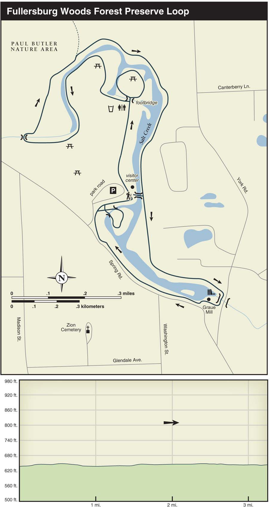
To start the hike, look for the crushed-gravel trail on the north side of the visitor center. After you pass a wide point in the creek, continue straight ahead over the bridge that leads to a part-time island. Head to the left. During the short stroll around the island, you’ll pass a picnic shelter and a dried pond bed on the right.
Crossing the bridge again, turn right, passing a water pump and restrooms on the left. Here, the trail meanders beside an attractive stretch of Salt Creek: Trees hang lazily over the water, and, on the opposite bank, a small bluff rises above the creek. Just ahead, the trail passes an impressive stone picnic shelter with benches and a fireplace. Many of the Fullersburg picnic shelters, as well as the log visitor center and the Graue Mill, were built or restored by the Civilian Conservation Corps, which had a camp here in the 1930s. Beyond the large boulders on the left, stay to the right at the next five trail junctions.
After crossing Salt Creek again, you’ll pass a trail heading left into the Paul Butler Nature Area. If you wish to add an extra mile or so to your hike, take this narrow footpath as it follows the creek upstream to a small dam. Reaching the pond beyond the dam, I suggest turning around and heading back to the main trail (the remainder of this trail can be flooded in spots and is noisy due to traffic on 31st Street).
Continuing on the main trail, the path curves left, away from Salt Creek, and then rises up a small hill. As the path returns to the side of the creek, look for the trail you just hiked on the other side of the creek. On the left, you’ll soon pass the other end of the trail for the Paul Butler Nature Area. Not long after the landscape drops down to creek level, you’ll pass over a couple of small streams; the first is intermittent, and the second looks as though it runs year-round. As you pass the island you hiked earlier, you’ll start to see backyards of houses on the left. At 1.9 miles into the hike, a picturesque log bridge leads over Salt Creek to the visitor center.
After the bridge, the path runs straight south as the creek slowly curves to the right. When you meet back up with the creek, the water grows wider, until you reach the dam, which is flanked by the brick Graue Mill and its giant waterwheel. For anyone with an interest in local history and water mills, the Graue Mill is well worth a visit. Cross York Road on the footpath, and head over to the front door of the mill, which faces the former Graue House. The owner of the mill, Frederick Graue, once lived here with his family.
For a small admission fee, you can hear a 20-minute presentation in which a white-aproned miller explains the 15,000-year-old practice of grinding grain and how it was done here. After Fredrick Graue built the mill in 1852, three generations of his family operated the mill until 1912, and it continued as a working mill until 1929. At the end of the presentation, the miller grinds a half-bucket of cornmeal using the mill’s original millstones, which are made from a type of quartz—known as buhrstone—imported from France. While the millstones are now powered by electricity, sets of giant wooden gears in the basement are set up as they would have been when the waterwheel powered the millstones.
In the basement, you’ll learn that the mill was also a stop on the Underground Railroad. Along with other local stops in Plainfield, Aurora, Sugar Grove, Joliet, and Hinsdale, the Graue Mill was a part of the clandestine network of places where escaped slaves could rest and be fed on their way to Chicago, from which they could travel across the Great Lakes to Canada. On the second and third floors of the mill is a collection of artifacts from the period of 1850 to 1890, including room settings, farm implements, and a re-created general store.
From the mill, the path runs back to the visitor center between the dam’s backwater and Spring Road. Along the way, you’ll pass a sign explaining that Salt Creek got its name when a farmer’s wagon was stuck in the creek while hauling a barrel of salt. He left the wagon overnight and returned the next morning to find the salt had dissolved. Farther ahead, follow the trail branching to the right. Then take the short bridge to the right for a short loop around this little piece of land—sometimes an island—that sticks out into the water. Crossing back over the bridge, continue to the right until you see the parking lot on the left.
NEARBY ACTIVITIES
If you’d like to see more of Salt Creek, head over to Bemis Woods Forest Preserve, 1 mile directly east of Fullersburg Forest Preserve. Bemis Woods offers several miles of multipurpose trails and the western end of the Salt Creek bicycle path. This paved path runs for 6.6 miles east, ending at the doorstep of the world-renowned Brookfield Zoo. To reach Bemis Woods, turn left (southeast) on Spring Road as you’re leaving Fullersburg Park. After passing the Graue Mill, turn left (south) on York Road. Turn left (east) on Ogden Avenue and proceed for 1.2 miles. The driveway for Bemis Woods is on the left. The bicycle trail starts on the right just before the sledding hill.