24 GENEVA LAKE: North Shore Hike
KEY AT-A-GLANCE INFORMATION
LENGTH: 10 miles (one way)
CONFIGURATION: Linear path
DIFFICULTY: Difficult
SCENERY: Geneva Lake, historic mansions, bluffs, woodland, public parks, and 3 pleasant lakeside villages
EXPOSURE: Mostly shaded
SURFACE: Surfaces include grass, dirt, brick, gravel, stone, and concrete.
HIKING TIME: 3–4 hours
DRIVING DISTANCE: 80 miles from Millennium Park, downtown Chicago
ACCESS: Sunrise to sunset
WHEELCHAIR ACCESS: No
FACILITIES: Restrooms, water, benches, public parks, beaches, parking, and restaurants available at each town along the way
MAPS: USGS topos Walworth, WI, and Lake Geneva, WI
SPECIAL COMMENTS: Pets must be leashed. Hiking in late fall, winter, and early spring will require navigating your way around the many docks that are stacked up in homeowners’ yards. Because of the steps and steep inclines, snow and ice would make this hike very difficult.
GPS TRAILHEAD COORDINATES
Latitude 382030
Longitude 4716190
Directions
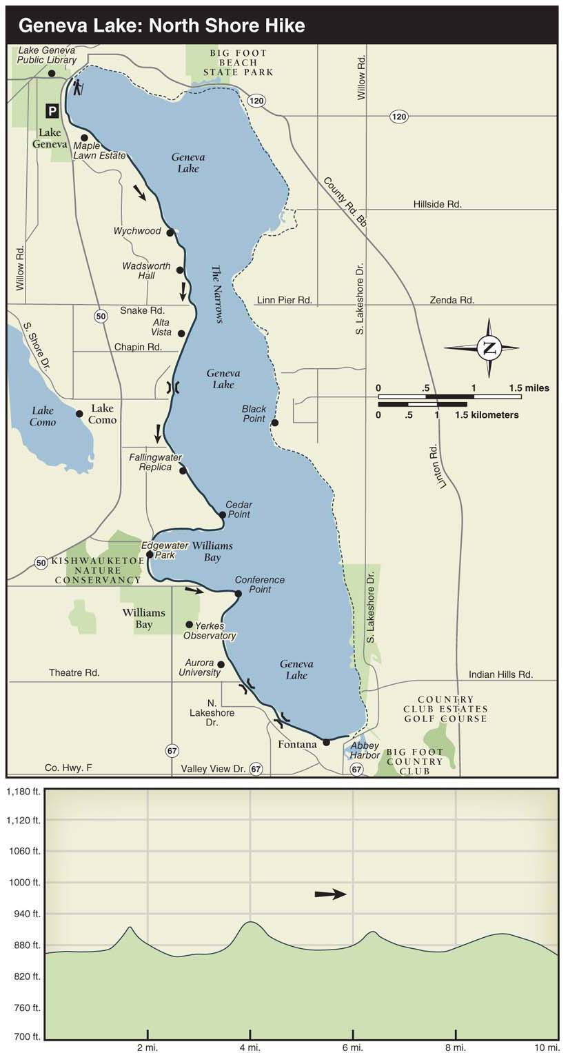
Take I-90/I-94 west, proceeding along I-94 as it splits off northward. Exit I-94 at IL 173 (Rosecrans Road). Follow IL 173 west for 17.8 miles until reaching US 12. Turn right (north) on US 12 and follow it for 10 miles to WI 50. Turn left (west) and drive 1 mile to downtown Lake Geneva. Because parking spots near the lake are metered, I suggest parking on one of the side streets just north of WI 50. After passing Broad Street, turn right (north) on Cook Street. Then turn left (west) on Geneva Street as it runs beside the school and look for a spot. After parking, follow Cook Street toward the lake where it turns into Wrigley Drive. Start the hike from the public library on the right.

IN BRIEF
It’s easy to see why so many wealthy Chicagoans built their opulent mansions on the shore of Geneva Lake (the lake is called Geneva Lake; the town is called Lake Geneva) during the late 19th and early 20th centuries. The views from the wooded bluffs along this silvery lake are fantastic. While enjoying the lake and the historic estates on this hike, you’ll encounter flower gardens, carefully landscaped lawns, boathouses, and pleasant little towns.
DESCRIPTION
In the early 1870s, after the Great Chicago Fire and the completion of a rail line connecting Lake Geneva with Chicago, estates began springing up on the shores of this Wisconsin lake. Many of the homes served as summer resorts for wealthy families with familiar names such as Maytag and Wrigley. After the turn of the century, clubs, youth camps, and expensive subdivisions started squeezing in between the sprawling estates.

Given the exclusive atmosphere at Geneva Lake, many people are surprised to learn that there’s a public footpath circumnavigating the entire lake. While not all landowners have been happy with the path, they’ve been legally obligated to leave their gates open since a court decision in the 1970s granted the public a “right of passage.” The court made its decision based on the fact that the pathway existed before homeowners bought their property. Indeed, before European settlers arrived in the area, the local Potawatomi Indians regularly used a narrow dirt trail along the entire shoreline of Geneva Lake. Many signs are posted asking you to stay on the path.
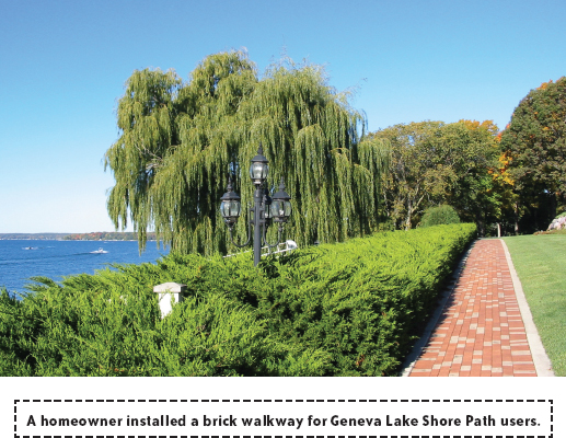
While walking through people’s yards may feel strange at first, this feeling diminishes once you see the many nice walkways installed by homeowners. Starting the hike from the park in back of the prairie-style library, follow the sidewalk to the right through Library Park. At the end of the park, the path turns to gravel and enters a yard. A sign just ahead identifies Maple Lawn, the oldest estate on the lake, dating from 1870. Next up are a number of newer homes, many with attractive flower bushes growing within carefully landscaped environments. After crossing a bridge over a rock-lined streambed and passing the nice lawns of Covenant Harbor Bible Camp, wooded bluffs start to rise along the shoreline.
Just ahead is a green-trimmed Swiss-style mansion built in 1876 called Northwoodside—once owned by the inventor of the paper milk-bottle cap. Between the estates on this section of the lake, the path runs through a number of brief wooded sections thick with weeping willows, sugar maple, and various oaks (because there are no public benches on the 7 miles between Lake Geneva and Williams Bay, consider discreetly using the logs and tree stumps in the wooded areas for your rest breaks).
At 2.5 miles into the hike, the path runs by Wadsworth Hall, a stately red-brick mansion from 1905 with six fluted columns in front. Near the House in the Woods (a large tan home with green shutters), there’s a stretch of woods where someone has installed little signs identifying nearly all the trees that line the path. Just ahead, climb a set of stairs up the bluff past an attractive chalet-style home, and then follow signs as the path heads down a steep, paved ramp with switchbacks. At the bottom of the ramp, the path cuts through a sandy beach. Not long after passing the narrowest section of the lake—appropriately called the Narrows—the path climbs a bluff leading to Alta Vista, a white stucco mansion with a red tile roof and a huge porch. Coming down from the bluff, the path flattens out and then crosses a beautifully crafted iron footbridge with sides featuring ferns, flowers, and bluebirds. At 3.5 miles into the hike, the path crosses Chapin Road.
Beyond Chapin Road, the path runs next to a tight cluster of homes known as the Elgin Club. The closeness of the homes, the streetlamps, and the asphalt pathway makes this stretch feel like a city street. After passing a couple of private parks, you’ll see a home that was intended to look like Frank Lloyd Wright’s famous house, Fallingwater.
At 5.6 miles into the hike, on a promontory called Cedar Point, you’ll climb a long flight of stairs up the bluff before taking in great views of Williams Bay. The dome of the Yerkes Observatory is visible on the other side of the bay. The path drops down as you get closer to the village of Williams Bay.
At 7 miles into the hike, across East Geneva Street from the boat launch in Edgewater Park, is one of the entrances to the Kishwauketoe Nature Conservancy, which offers nearly 4 miles of trails through a marsh and bottomland. After traversing a couple of wooden footbridges and passing a statue of a Potawatomi Indian woman, you’ll brush against the main business strip in Williams Bay. A few restaurants are located just to the right on WI 50.
Continuing on the trail, you’ll soon pass through the boatyard at Gage Marine, the owner of the Geneva Lake tour boats. If boats are blocking the path, go around them and stay to the left. Passing a handful of old youth camps, the wooded bluffs rise steeply on the right as you get closer to Conference Point. From Conference Point, the path continues at the bottom of the wooded slope as it passes a big boulder called Kissing Rock. The cluster of brown cottages signals your arrival at Aurora University at 8.7 miles. The chairs and concrete wall on the veranda provide a nice place for taking a break. After the university, you’ll catch glimpses of a series of houses perched high up on the bluff, followed by some pleasant wooded stretches and a number of attractive fieldstone footbridges. In the village of Fontana, the path runs between the boat launch and Pioneer Park. Farther ahead, after passing a restaurant, you’ll see Reid Park, a beach, and Abbey Harbor.
To learn more about the historic houses, camps, and other sights along the way, send $7 to “Walk, Talk & Gawk: A map and guide of the Geneva Lake Shore Path,” P.O. Box 413, Lake Geneva, WI, 53147. To receive “Touring the Geneva Lake Shore Path” ($5), call (800) 386-3228. Both guides are available at the Bread Loaf Bookshop (825 Wrigley Drive) located near the Lake Geneva Public Library.
NEARBY ACTIVITIES
Consider taking two cars for this hike and parking one at each end of the hike. Or you might want to get a lift back to Lake Geneva from a tour boat. Reservations are a must. The tour boat season runs from May 1 to October 31, depending on the weather. Call (800) 558-5911 or visit cruiselakegeneva.com for schedules and pricing.
Considered one of the birthplaces of American astronomy, the Yerkes Observatory, on the outskirts of Williams Bay, has been operated by the University of Chicago since 1897. The observatory is open every Saturday for free public tours, beginning at 10 a.m., 11 a.m., and noon. There’s also a small museum that’s open at the same time as the tours. For more information, call (262) 245-5555, Ext. 832, or visit astro.uchicago.edu/yerkes/visiting.
While the southern shore of Geneva Lake may not have as many historic homes or as many wooded sections as the northern shore, it’s still a fine location for a stroll. Continuing a counterclockwise trip around the lake from Fontana, the path runs by a replica of a tugboat moored in the water and then passes by a series of exclusive clubs. As you get closer to the promontory called Black Point, the path becomes wooded, narrow, and occasionally steep. On the point, look high up on the bluff to see a four-story tower that is part of a Queen Anne Victorian mansion also called Black Point. At 5.2 miles, the Linn Pier boat launch offers weary hikers a picnic table and a restroom.
At 6.3 miles, after following several fairways at the Geneva Country Club Golf Course, watch carefully for signs directing you through a residential neighborhood and along a couple of quiet paved roads. On the second paved road, look for the sign posted on a tree directing you to the right through the grassy lawn. After passing through a gate, follow Burr Oak Road to Hillside Road. Take Hillside Road left to the boat launch, which has picnic tables, restrooms, and a water fountain. At 8.4 miles, Big Foot Beach State Park’s lagoon appears on the right. For more hiking, there are several miles of hiking trails at Bigfoot Beach State Park.