32 DES PLAINES RIVER TRAIL: Old School To Independence Grove
KEY AT-A-GLANCE INFORMATION
LENGTH: 9.5 miles
CONFIGURATION: Out-and-back
DIFFICULTY: Easy to moderate
SCENERY: Bottomland woods, Des Plaines River, ponds, lakes, marshes, prairies, savanna
EXPOSURE: One-third of the route is exposed; the rest is mostly shaded
SURFACE: Crushed gravel
HIKING TIME: 3–4 hours
DRIVING DISTANCE: 38 miles from Millennium Park, downtown Chicago
ACCESS: 6:30 a.m.–sunset
WHEELCHAIR ACCESS: Yes
FACILITIES: Old School Forest Preserve has water, restrooms, and picnicking areas. Independence Grove Forest Preserve offers boat and bike rentals, a swimming beach, ice-skating, a sledding hill, a visitor center, and a seasonal café.
MAPS: Map boards are located in the forest preserve at the hike’s beginning and the turnaround point. Paper maps are sometimes available at the boards. Download maps from lcfpd.org/preserves; Libertyville IL, USGS topo
SPECIAL COMMENTS: Trail junctions are well marked, indicating access points and the “DPR” (Des Plaines River Trail) heading north and south.
GPS TRAILHEAD COORDINATES
Latitude 423794
Longitude 4679778
Directions
Take I-94 north from Chicago. Exit at IL 176 (East Park Avenue) and turn right (west). After 0.8 mile, turn left (south) on St. Mary’s Road. Look for the entrance to Old School Forest Preserve on the left. Follow the road to the right and park in the first parking you encounter. Look for the sign pointing to the Des Plaines River Trail at the far western edge of the parking area.
Public transportation: The Milwaukee District/North Metra Line stops in Libertyville less than 1 mile from the Des Plaines River Trail. The route from the train station to the trail runs along quiet streets and has paths and sidewalks along the way. Just north of where the train crosses IL 21 (North Milwaukee Avenue), take Appley Avenue east. Turn left on West Oak Spring Road. The trail crosses the road after you pass Minear Lake on the left.

IN BRIEF
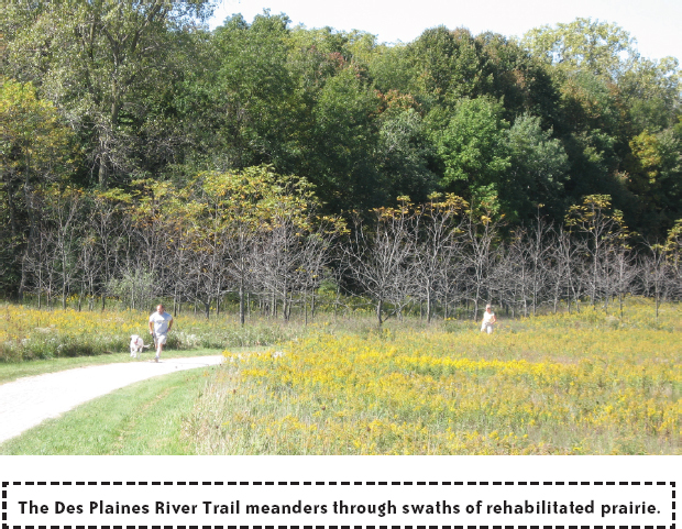
If you like riparian landscapes, you’ll love the Des Plaines River Trail as it winds alongside tree-laden riverbanks, through dense bottomland woods, alongside ponds, and over footbridges spanning the river. There are also quiet oak savannas and many acres of tallgrass prairie thick with goldenrod, asters, and big blue-stem prairie grass.
DESCRIPTION
Given all the development in the area surrounding the Des Plaines River, it may come as a surprise to see how much nature lines the river. Indeed, the many forest preserves that accompany the Des Plaines River in Lake and Cook counties serve as the longest greenway in the Chicago region. In addition to the aesthetic, recreational, and health benefits these greenways have for humans, ecologists will tell you these long, extended natural areas offer many advantages for local plants and animals too. Plants and animals tend to be healthier when they are not cut off from one another and are able to be part of a larger gene pool. Animals, of course, are more likely to thrive if they have room to move around and don’t have to cross busy roads regularly.

In Lake County no fewer than 10 forest preserves lie along a continuous path within the Des Plaines River Valley. Spanning nearly the entire length of Lake County, the north section of the Des Plaines River Trail gives people an extended encounter with this attractive river and the surrounding—mostly wet—landscape. This hike is just a small slice of this portion of the trail as it runs the entire north-south span of Lake County. (To the south in Cook County, the Des Plaines River Trail runs for about another 20 miles or so—although not continuously.)
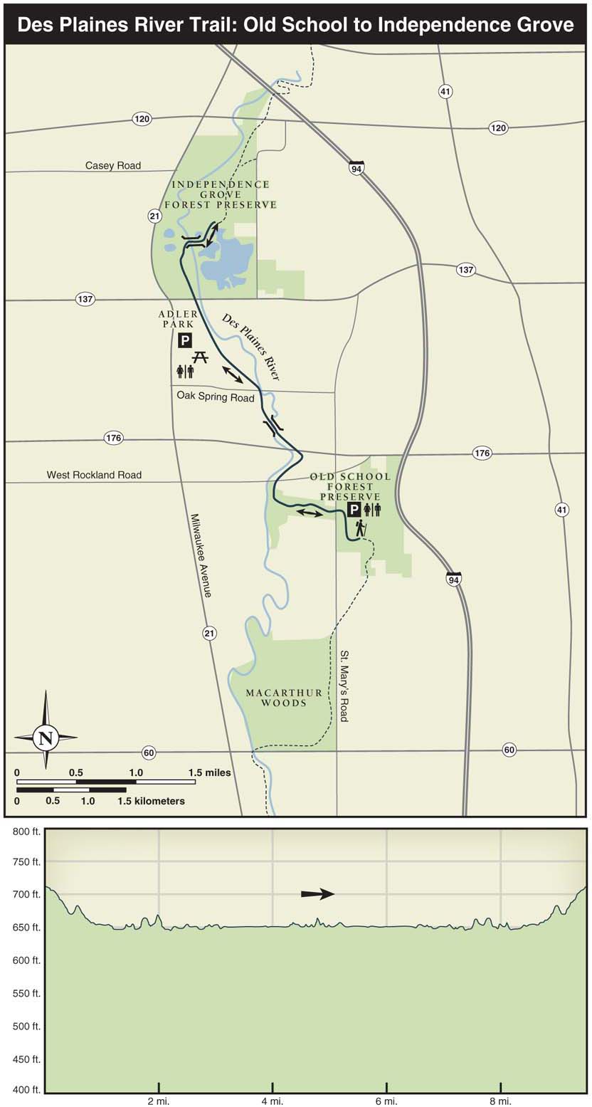
Once you’ve located the Des Plaines River Trail on its way through the woodland in the southwest corner of Old School Forest Preserve, take the trail to the right. After ducking under St. Mary’s Road, the trail enters a prairie landscape where you’ll find plants such as goldenrod, heath, and sky-blue asters, and big bluestem prairie grass. (Hikers will encounter five road crossings each way on this excursion. Thanks to careful planning, the trail runs under the busy roads. Occasionally, however, the rising river swallows up underpasses. The county posts signs during flooding, and you can simply cross the road at street level instead.) The prairie gradually slopes down in the direction you’re traveling—toward the Des Plaines River. Even though development exists on both sides of this piece of pathway, it’s off in the distance and doesn’t feel cramped. Getting closer to the river, the path curls to the right and runs through a riverside savanna and across West Rockland Road. You’ll pass near a housing development and through thick bottomland woods and brush against a pond before heading under IL 176 and the North Shore Bike Path. (The bike path runs along IL 176 for 7.5 miles between Mundelein and Lake Bluff.)

Continuing north, the trail winds through woodland dense with maple, hickory, and oak trees. After crossing one of the many handsome wood and steel pedestrian bridges along the trail, it enters an area with many marshy spots and a scattering of ponds—some ponds with open water and others covered in bright green algae and littered with dead logs. After crossing Oak Spring Road, you’ll see Minear Lake over the embankment on the left. Minear Lake, like many of the lakes and ponds along the river, was created by a former gravel mining operation. Soon you’ll pass Adler Park, which is located up the bluff on the left. (The park has picnicking areas, water, restrooms, and a Frisbee-golf course.) As you cross IL 137, you’ll see an abundance of development along IL 21 to the west.
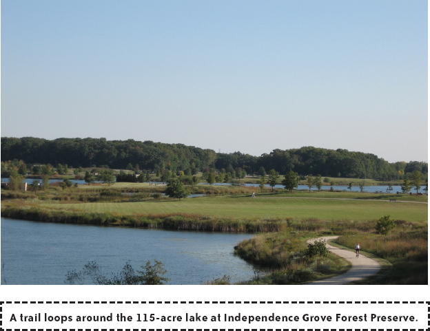
Entering Independence Grove Forest Preserve, the trail cuts through an attractive gently rolling prairie and then passes a couple of ponds (also former gravel pits) on the left before crossing a pedestrian bridge into the main part of Independence Grove. In Independence Grove, you can turn around and head back to Old School Forest, or you can explore the 6 miles of trails that the circle the lake within Independence Grove. Or you may want to push ahead on the Des Plaines River Trail to see the sights farther upstream. (See Nearby Attractions for information about other sections of the Des Plaines River Trail.) First, though, you’ll want to continue ahead a bit on the Des Plaines Trail as it mounts a hill and allows an expansive view of the 1,110-acre preserve and the 115-acre lake at Independence Grove.
NEARBY ACTIVITIES
For a completely different set of views of the Des Plaines River, consider a paddling trip. Five canoe launches are in the area (including launches at Oak Spring Road and at Independence Grove). Call the Lake County Forest Preserve District for information on launch sites and rentals.
Ready for more hiking along Des Plaines River Trail? If so, you’ll find more attractive prairie, savanna, and woodland along the trail north of Independence Grove. From Independence Grove, it’s 2.5 miles north to IL 120. You’ll know you’re getting close to IL 120 when the trail weaves in and out of the power line right-of-way. North of IL 120, the path loses some of its luster as it encounters a series of busy roads, including I-94. Hiking south from the starting point at Old School Forest Preserve, you might consider following the Des Plaines River Trail for 2.4 miles to IL 60. From Old School Preserve, the path threads its way through patches of prairie and woodland before crossing Old School Road and then running through a savanna that sits beside railroad tracks. Passing under the tracks and crossing St. Mary’s Road brings you to MacArthur Woods—an Illinois Nature Preserve with an attractive mix of woodland and savanna. Among the hickories, maples, and oaks at MacArthur Woods, look for birds such as brown creeper, red-shouldered hawks, and pileated woodpeckers. When the trail starts to run alongside a busy road, you’ll know you’ve reached IL 60.