40 INDIANA DUNES NATIONAL LAKESHORE: Cowles Bog Trail
KEY AT-A-GLANCE INFORMATION
LENGTH: 4 miles
CONFIGURATION: Loop
DIFFICULTY: Moderate
SCENERY: Dunes, beach, marshes, woods, and savannas
EXPOSURE: Shady except for 0.2 mile along the beach
SURFACE: Dirt, sand
HIKING TIME: 1.5–2 hours
DRIVING DISTANCE: 47 miles from Millennium Park, downtown Chicago
ACCESS: 6 a.m.–sunset
WHEELCHAIR ACCESS: No
FACILITIES: Parking, restrooms
MAPS: Park maps available at trail board and on the park website at nps.gov/indu; USGS topo Dune Acres, IN
SPECIAL COMMENTS: If the weather is agreeable, consider a picnic at the beach.
GPS TRAILHEAD COORDINATES
Latitude 492818
Longitude 4610591
Directions
Take I-90/I-94 south until reaching the Chicago Skyway (I-90), Exit 59A. After traveling 29 miles southeast on the Skyway and the toll road, take Exit 21 to I-94. Follow I-94 east for 7 miles to Exit 22B. Follow US 20 (Melton Road) for 1.5 miles, and then bear left (north) on North Mineral Springs Road. The parking lot for the Cowles Bog Trail is 1.5 miles ahead on the right, just before the Dune Acres guardhouse.
Public transportation: Take the South Shore Line to the Dune Park station. Follow the Calumet Bike Trail west for 1 mile as it runs alongside the railroad tracks. Turn right at Mineral Springs Road and follow it for one-half mile north to the trailhead.

IN BRIEF
Cowles Bog Trail runs past wetlands, through oak forests, and over wooded dunes that increase in height as you approach the sandy beach.
DESCRIPTION
As one of the more famous spots at Indiana Dunes National Lakeshore, Cowles Bog is well known for its beauty and historical significance in the field of environmental science. Shortly after starting the hike from the Cowles Bog Trail parking lot, you’ll pass a plaque on the right honoring Henry Cowles, the trail’s namesake. His work in the early 20th century helped establish the science of ecology. Cowles, a professor at the University of Chicago, was drawn to Cowles Bog—and Indiana Dunes in general—partly because of its impressive variety of plants. According to botanical surveys, there are more types of plants within the 12,000 acres of Indiana Dunes National Lakeshore than there are in the half million acres within Great Smoky Mountains National Park.

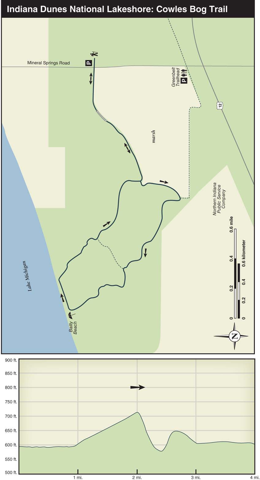
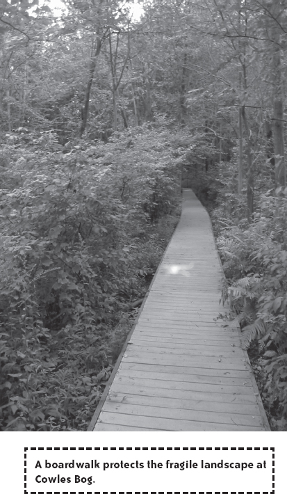
At 0.3 mile, a 200-foot-long boardwalk leads hikers through a lush marshy area. After the boardwalk, the trail runs close to the shore of more marshland. Although the interior of this wetland is called Cowles Bog, it’s actually a fen. Fens have soil and water that are alkaline, whereas bogs are acidic; different plant communities inhabit each.
Turn left at the first trail junction, which appears at 0.8 mile. After skirting the west side of the large marsh for 0.3 mile, turn right at the next junction. Intermittent marshes with cattails and sedges appear on each side of this trail. Also on this stretch of the trail, you’ll see some of the heavy industry that makes the existence of the National Lakeshore such an unlikely prospect. The behemoth on the left is Northern Indiana Public Service Co., a coal-fueled power plant that provides electricity to the local steel industry.
Keep straight ahead when reaching another connector trail on the right at 1.7 miles. As the oak forest becomes thicker, the dunes start to bulge upward. The dunes come and go quickly, creating sudden dramatic shifts in the terrain, steeply sloping in one direction and then another. Getting closer to the shore, the dunes begin to soar—and so does your heart rate as you climb these steep, sandy slopes. If it’s a hot summer day, keep in mind there’s a cool, wet reward at the bottom of the last dune.
At 2.2 miles, the trail drops down to Bailly Beach, where, on a clear day, the skyscrapers of downtown Chicago are visible to the northwest. This beach is a popular spot for boaters on summer weekends; during the rest of the year and on weekdays, however, this beach is seldom used because it can’t be reached by car. If a picnic or sunbathing is on the agenda and boats are anchored offshore shoulder to shoulder, look for a quieter stretch of beach a half mile or so to the right. Try walking just beyond the fenced-in area that serves as a nesting site for the federally endangered piping plover (a pale-whitish sparrow-sized bird sporting a black breast band).
The trail continues up a dune 0.2 mile to the right of where you arrived on the beach. Back on the trail, take note of how quickly the vegetation changes from hearty dune grass toward the beach to oak woods at the top of the first dune. This swift transition fascinated Henry Cowles and prompted him to investigate why oak trees didn’t grow closer to the lake. In the course of his research here, he observed that oak trees and other plants need decomposed plant material in which to grow. As dune grasses die and add organic material to the sand, groundwork is laid for oak trees to sprout. In time, oak trees and other plants replace the dune grass. Through such observations, Cowles pieced together one of the major concepts in the field of ecology: as plants grow on a site, they change it.
Dropping down on the back side of the first dune, the sound of wind and water is hushed by the mounds of sand. Amid the stands of black oak and jack pine, look for flora rarely seen in the Chicago region, including the prickly pear cactus (it blooms yellow flowers in midsummer), blueberries, and, closer to the marshes, birch trees and large ferns. Continue straight ahead as you pass the first connector trail on the right, at 0.4 mile beyond the beach. Except for a few open spaces littered with large fallen branches, the trail in the summer is shaded under a canopy of oak leaves. Passing the second connector trail at 0.9 mile beyond the beach, the terrain flattens and leads you along the marsh and back to the parking lot.