42 INDIANA DUNES NATIONAL LAKESHORE: Bailly/Chellberg Hike
KEY AT-A-GLANCE INFORMATION
LENGTH: 3.3 miles
CONFIGURATION: Combo
DIFFICULTY: Easy
SCENERY: Bottomland forest, marshland, oak woodland, Little Calumet River, a 19th-century working farm, and an early trader’s homestead
EXPOSURE: All shaded, except through the prairie
SURFACE: Dirt, grass
HIKING TIME: 2 hours
DRIVING DISTANCE: 46 miles from Millennium Park, downtown Chicago
ACCESS: 8 a.m.–sunset
WHEELCHAIR ACCESS: No
FACILITIES: Picnic tables and shelters, visitor center, restrooms
MAPS: Maps available at the mapboard and in the visitor center; USGS topo Chesterton, IN
SPECIAL COMMENTS: The Chellberg Farmhouse and the Bailly Homestead are occasionally open to the public for special events. Learn more by visiting nps.gov/indu.
GPS TRAILHEAD COORDINATES
Latitude 492570
Longitude 4607900
Directions
From Chicago, take I-90/I-94 south until reaching the Chicago Skyway (I-90), Exit 59A. After traveling 29 miles southeast on the Skyway and the toll road, take Exit 21 to I-94. Follow I-94 east for 7 miles until reaching Exit 22B. Follow US 20 (Melton Road) for 4.1 miles. The entrance to the parking lot is on the left.

IN BRIEF
Get a glimpse of early settlement life in northwestern Indiana by touring the homesteads of two frontier families. You’ll also see wooded ravines, rich bottomland forest that grows beside the Little Calumet River, and a curious old cemetery.
DESCRIPTION
In 1874, ten years after emigrating from Sweden, Anders and Johanna Chellberg were farming 80 acres within a growing Swedish community in northwest Indiana. Over the years, three generations of Chellbergs made their living on the farm growing wheat, oats, corn, and rye and keeping farm animals. The Chellbergs farmed the land until 1972, when the National Park Service bought the property. To preserve the past, the park service continues operating this typical northwest Indiana farm in the same manner that the Chellbergs operated it in the late 1800s.
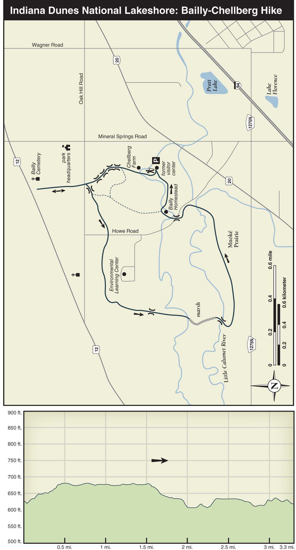
The hike starts 100 yards south of the farm, at the backside of the former visitor center, where you’ll follow the trail to the right as it runs along the top of a 40-foot wooded ravine. (Unfortunately, in recent years, the visitor center has been shut down.) The first farm building you’ll pass is the maple-sugar house, followed by a windmill with a pump house, a harness shop, a corncrib, a chicken house, the restored brick farmhouse built in 1885, and the large 100-year-old barn. Kids will enjoy the roaming chickens, the horses in the barn, and the hogs in the pen beyond the barn. Inside the farmhouse, visitors can tour the parlor, the kitchen, and a bedroom as they looked in the early days of the farm.

Continuing on the trail, cross a bridge and then follow a set of steps down into a pleasant wooded ravine carved by a running stream. Crossing several more bridges, the trail runs along the bottom of the ravine for a short stretch until a flight of stairs brings you back up to flat ground. Cross another bridge and then turn right at the junction for the out-and-back trail to the Bailly Cemetery. On the way to the cemetery, cross Oak Hill Road and a crushed-gravel trail, and then hike 0.3 mile through bottomland forest. The cemetery—a walled-in earthen area built on a small hilltop—has a tomblike quality to it. The wall was built in 1885 on what archeologists have surmised to be an existing cemetery: bones thought to predate European settlement have been uncovered at this site. After circling the cemetery, retrace your steps back to the main trail.
Back on the main trail, cross a bridge and then stay to the right at the next junction. Soon the trail crosses Howe Road and a crushed-gravel trail that leads to the Indiana Dunes Environmental Learning Center—a frequent stop for school groups visiting the dunes. After passing a spur trail on the left leading to the learning center, you’ll see the building on the left through stands of hickory, maple, and locust trees. After passing between a few big white oaks on both sides of the trail, the trail turns left toward the Little Calumet River. From here, the woodland becomes shrubby savanna as the trail runs through a few small ravines.
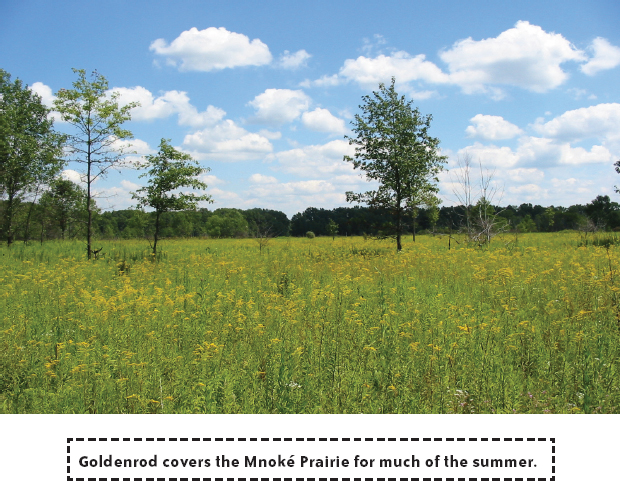
At 1.9 miles into the hike, a 0.2-mile boardwalk carries you through a wet bottomland forest and a marshland and ends at a scenic spot where a metal footbridge spans the Little Calumet. Stay to the left at a junction 0.2 mile beyond the bridge. After the trail curves left, you’ll have sporadic views of the river, marshy areas, and the cattails at the bottom of the ravine. In the riverside areas, groundcover plants are scarce due to the dense, leafy canopy above. Soon, the trail leaves the riparian landscape behind and enters the 120-acre Mnoké Prairie. After passing through this picturesque prairie and a short stretch of woodland, the trail arrives at a parking area. From the parking area, descend the hill, and then stay to the left, heading toward the bridge on Howe Road.
On the other side of the bridge, immediately turn right on the brick road that heads up the short hill to the Bailly Homestead. Montreal-born Honore Gratien Joseph Bailly de Messein was one of the first settlers in northwest Indiana when he arrived in 1822 to start a trading post. Well-suited for trading due to the river and the intersection of two major Indian trails, Bailly exchanged blankets, guns, and cooking pots for skins of beaver, muskrat, and mink. As animals became scarce and the trading slowed, Bailly turned his attention to operating a local tavern and establishing a small community named after him, which was on land now occupied by Bethlehem Steel.
On the right is the restored wooden frame house built by the Bailly family in 1835. Though Bailly died before construction of the house was finished, his family occupied the house until 1917. Over the years, the six-bedroom house has been a restaurant, an antique shop, and a retreat for an order of Catholic nuns. The ground floor of the house—unfurnished except for a beautiful fireplace mantel built by a local craftsperson—is open to the public on Sundays during the summer. Also on the property are a two-story cabin that served as employees’ quarters, a small brick house, a chapel, and a reconstructed fur-trading cabin.
Beyond the house and the cabins, the path on the left, which leads to the Bailly Cemetery, is said to be part of an old Indian trail. The hike continues on the right, just beyond the wigwam frame and the National Historic Marker plaque. From the Bailly Homestead, it’s a short woodland hike back to the parking lot.
NEARBY ACTIVITIES
Just a few miles away, historic downtown Chesterton offers a couple of good dining options. Lucrezia Café at 428 South Calumet Road, (219) 926-5829, offers authentic Italian cuisine, and Popolano’s Restaurant at 225 South Calumet Road, (219) 926-5552, has good family fare. To reach Chesterton from the parking lot, turn right (south) on North Mineral Springs Road, turn left (east) on West Beam Street, and then turn right (south) on Sherman Avenue (Wagner Road), which quickly turns into North Jackson Boulevard. Turn left (east) on Broadway Avenue and then turn right (south) on South Calumet Road.