50 GOODENOW GROVE HIKE
KEY AT-A-GLANCE INFORMATION
LENGTH: 2.9 miles
CONFIGURATION: Several connected loops
DIFFICULTY: Easy
SCENERY: Wooded ravines, creek, grassland, savanna, and ponds
EXPOSURE: Mostly shaded
SURFACE: Dirt, mowed grass, pavement
HIKING TIME: 1.5 hours
DRIVING DISTANCE: 37 miles from Millennium Park, downtown Chicago
ACCESS: April–October, 8 a.m.–8 p.m.; November–March, 8 a.m.–5 p.m.
WHEELCHAIR ACCESS: No
FACILITIES: Nature center, restrooms, water fountains, picnic tables and pavilions, rustic camping, and a wheelchair-accessible trail
MAPS: Maps available in nature center and at reconnectwithnature.org; USGS topo Dyer, IL
SPECIAL COMMENTS: Goodenow Grove Forest Preserve will be closed until July 2012 for a $2 million rehab project focusing on the campground, some park roads and parking areas, and the development of a new 3-mile paved trail. In winter, the hill serves as a premier sledding destination. The preserve provides free inner tubes for sledding. Call (815) 727-8700 or visit reconnectwithnature.org for information about camping at Goodenow.
GPS TRAILHEAD COORDINATES
Latitude 449319
Longitude 4583301
Directions
From Chicago, take I-90/I-94 south. Stay on I-94 for 15.1 miles after I-90 splits off. When I-94 reaches I-80, continue straight ahead on IL 394. Follow IL 394 for 14 miles. Turn left (east) on West Goodenow Road and proceed for 1.2 miles. Turn left (north) on Dutton Road and follow signs to the Plum Creek Nature Center.

IN BRIEF
If you arrive early, you’ll likely have these rolling hills, open grasslands, wooded ravines, and winding creek all to yourself. This delightful forest preserve remains undiscovered by people outside of the immediate area.
DESCRIPTION
For a 700-acre nature preserve, Goodenow Grove has a lot to offer. Along with hiking and picnicking, there is primitive camping and a nature center with a number of exhibits to engage kids. In winter, the preserve clears a pond for ice skating and provides inner tubes for a sledding hill in the center of the preserve.
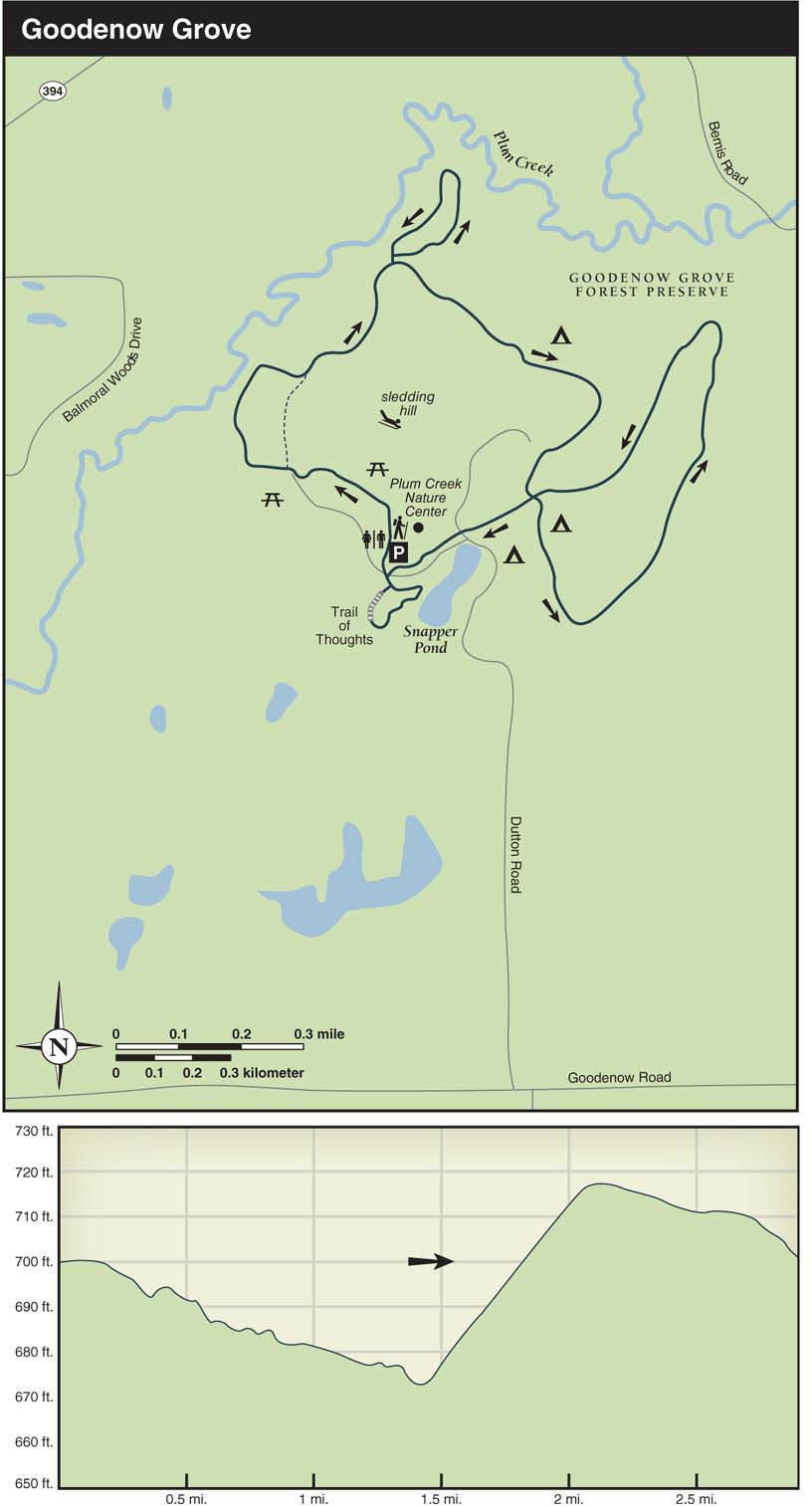
You might start this hike with a quick trip up the sledding hill for a view of the surrounding area. On the way down the hill, take the paved path to the right leading into the next parking area. Keep going past the main trailhead on the right and look for the second trailhead. This is where you’ll head into the dense oak woods. After passing a side trail on the right, the trail pulls alongside a 40-foot-deep wooded ravine carved out by Plum Creek. Just beyond the old concrete foundation, turn left on the gravel trail. From this junction, the trail winds through groves of shrubs that soon give way to open space and savanna. At the picnic table (0.65 mile into the hike), take a left on the dirt trail leading into a dense and lush woodland beside Plum Creek. Stay to the right at the fork; the trail gains elevation and passes a few large oaks and scattered deadfall. A ravine containing bottomland forest and another section of Plum Creek opens on the right. As the trail takes a sharp turn left, it roughly follows the edge of this picturesque wooded ravine.

Returning to the gravel trail, head left as the trail rises. In the camping areas, several spur trails lead toward the sledding hill. A small cattail marsh appears on the right before reaching the parking lot for campers. Take the road heading left from the parking lot, then turn left again at the sign for Foxfire Group I Camping.
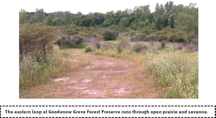
This 1-mile loop section of the hike starts 20 yards to the right through the camping area. As you climb a wooded hillside, the trail turns into a wide, mowed path and then passes a few buildings on the right. After the buildings, the trail curves left, drops into a short but steep ravine, and then enters an open space sprinkled with pines, oaks, apple trees, and shrubs.
Climbing a gradual hill, you’ll have a nice view of the landscape that includes shrubs, thickets, and woods. From the hill, the trail swings left and then drops down next to goldenrod plants and sumac trees, and then runs through a wooded stretch before returning to the group camping area. In the camping area, continue straight past the restrooms and the water fountain back to the gravel trail, where you’ll turn left. After crossing a small creek and passing Snapper Pond on the left, cross the park road and follow the path up the hill to the back side of the nature center. At the nature center, stay to the left, passing by some picnic tables and through the rows of lilies, black-eyed Susans, and mint in the herb-and-flower garden.
The final section of this hike—called the Trail of Thoughts—starts across the park road in the Nodding Oaks picnic area. From the picnic area, stay to the right as you follow the paved path over a boardwalk, past a few benches and a wet prairie. You’ll see that the trail gets its name from the nature quotations posted on signs along the way. The scenery gets wetter as the trail continues past a small pond and past viewing platforms at the edge of a cattail marsh and Snapper Pond. Complete the loop and follow the trail back up the hill to the parking lot.
NEARBY ACTIVITIES
Not far away are a couple of nice outdoor-recreation areas owned by the Will County Forest Preserve District. The Monee Reservoir—a popular spot with fishermen, boaters, and picnickers—offers 2.5 miles of mowed turf trails near the 46-acre reservoir and through adjoining wetlands. Visitors can rent rowboats, canoes, and pedal boats, as well as other recreation items such as horseshoes and stakes and snowshoes in the winter. The reservoir is open 6 a.m. to 8 p.m. during summer and 8 a.m. to 5 p.m. during winter. Call (708) 534-8499 for more information.
Just east of the reservoir on the other side of the Illinois Central Gulf Railroad tracks and Governors Highway is the 210-acre Raccoon Grove Forest Preserve. Raccoon Grove has a half-mile trail that leads through gently rolling woodland and along the shore of Rock Creek. Hours are 8 a.m.–sunset. From Goodenow, take Dutton Road south to Goodenow Road. Take Goodenow Road to the right and drive 8 miles (Goodenow Road becomes West Pauling Road halfway along this stretch). Shortly after passing Raccoon Grove Forest Preserve on the left, take South Ridgeland Road left to reach the reservoir.