59 KANKAKEE RIVER STATE PARK HIKE
KEY AT-A-GLANCE INFORMATION
LENGTH: 4.8 miles
CONFIGURATION: Out-and-back
DIFFICULTY: Easy
SCENERY: Kankakee River, bluffs, limestone canyon along Rock Creek
EXPOSURE: About half exposed and half shaded
SURFACE: Paved path, dirt
HIKING TIME: 2.5–3 hours
DRIVING DISTANCE: 61.7 miles from Millennium Park, downtown Chicago
ACCESS: April 1–October 31, 7 a.m.–10 p.m.; November 1–March 31, 7 a.m.–6 p.m.
WHEELCHAIR ACCESS: No
FACILITIES: Picnic areas, concession stand, bike and canoe rental, restrooms, park office, water fountains
MAPS: Maps available at the park office and online at dnr.state.il.us; USGS topo Bourbonnais, IL
SPECIAL COMMENTS: Exercise caution while looking out from the ledges along Rock Creek—especially if kids are along. The seasonal concession stand offers ice, vending machines for drinks, bait, and canoes and bicycles for rent. Dogs must be kept on leashes.
GPS TRAILHEAD COORDINATES
Latitude 415088
Longitude 4562406
Directions
Take I-90/I-94 south from Chicago. Continue on I-94 to I-57 south. Follow I-57 south for 42.7 miles. At Exit 315, head south on IL 50 for 0.3 mile to Armour Road. Turn right (west) on Armour Road and proceed 2 miles to IL 102. Turn right (northwest) on IL 102 and continue 5.8 miles to the park’s visitor center, where you can pick up a park map. From the visitor center, continue heading northwest on IL 102 for 1.7 miles to Warner Bridge Road. Turn left on Warner Bridge Road. The parking lot is on the right, just before the bridge.

IN BRIEF
The first section of this river hike takes you along the wooded bluffs above wide sections of the Kankakee River. After crossing a pedestrian suspension bridge, you’ll follow Rock Creek along a dramatic canyon to a frothy waterfall.
DESCRIPTION
The focal points of Kankakee River State Park are the craggy cliffs and vertical walls of Rock Creek Canyon as it gently curves toward the Kankakee River.
This beautiful and dramatic rock formation has been captivating visitors for many generations. At the time of the first European contact, the Miami Indians were numerous along this part of the Kankakee River; by 1770, Indians from the Potawatomi, Chippewa, and Ottawa tribes—known as the “three fires”—dominated the area. The last Indian settlement at the confluence of Rock Creek and the Kankakee River was a sizable Potawatomi village. Most of the Potawatomi had been removed by the end of the decade, except for Chief Shawanasee, who lived the rest of his life here and whose grave is commemorated with a boulder along a trail in the northern section of the park. (Unfortunately, the trail that runs by this boulder has been closed for the past several years because of erosion problems.)

Established in 1948, the park was greatly expanded over the years largely from land donated by Commonwealth Edison. Now Kankakee River State Park is 11 miles long and encompasses 3,932 acres, straddling both sides of the Kankakee River.
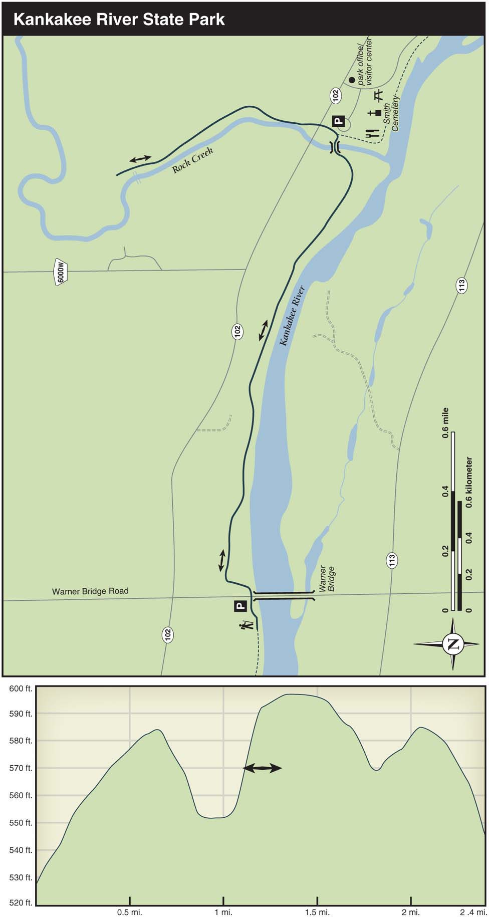
Before starting out from the Warner Bridge Road parking lot, I suggest taking a short walk to the right along the river to see the limestone pillars built to support a train bridge in the late 19th century. The bridge was never finished, however, because financiers ran out of money before the railroad was completed. Heading back toward Warner Bridge Road, the trail runs under the bridge before turning left and making a steep climb. At the top of the hill, you’ll pass a farm and an agricultural field on the left before the trail turns right toward the river. For the next mile the trail glides along the side of this wooded bluff about 40 to 50 feet up from the river’s edge. In some places, the drop to the river is steep enough for the park to have erected steel fencing along the trail. The season that you’re hiking will determine how well you can see the river; if the leaf cover is heavy, look for the occasional openings in the shrubs that will allow you to see shorelines in the distance and the low islands. Shortly after passing a picnic table with a shelter overlooking the river, the trail curves left up a hill toward the suspension footbridge spanning Rock Creek.
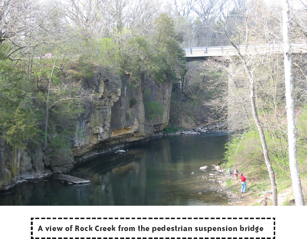
The bridge offers a great vantage point from which to enjoy the beginning of this dolomite rock canyon. The stone walls—sometimes vertical and sometimes slanted or steplike—become even more pronounced as you head upstream. On the other side of the bridge, at 1.6 miles into the hike, turn left to cross IL 102. On the other side of the highway, continue ahead, ignoring the old emergency-access sign.
Approach the cliffs on the left with care: there are no guardrails between you and a 50- to 70-foot drop to the water. Oak trees are often thick at the top of the cliff, but there are dozens of spots that allow for viewing the dramatic canyon and the river. At 0.3 mile after crossing the highway is a sign indicating that the waterfall is a half mile ahead. Just beyond the sign, the dilapidated pavement ends and the wide dirt path begins. To the right, a line of pine trees starts to run parallel to the trail. In a few places, you’ll see horse trails heading off to the right into the shrubby woodland. While these trails are on park-owned land, hiking on them is not encouraged.
At the next picnic table, look upstream for a view of the waterfall, which makes a sloping descent for about 8 feet. Enjoy the view while you can: according to the Illinois State Geological Survey, the waterfall is moving upstream at a rate of three inches per year. If you continue ahead, there’s another perch where you can look out directly above the falls. This is also where you’ll see the chain-link fence signaling that it’s time to turn around and head back toward the highway.
Crossing back over IL 102, the park visitor center is 0.15 mile to the left. Along with a few mounted animal and bird specimens, the visitor center hosts an impressive collection of fossils and arrowheads—nearly all of which were found in the park.
Heading toward the Kankakee River from the visitor center, you’ll come upon a paved path that runs next to the river. To the left, the path runs 1.8 miles through riverside picnic areas, near the community of Altorf, and next to the site of an old mill and distillery. From there, the path surface turns to crushed limestone and runs for 3.7 miles near the park’s Potawatomi Campground and through a secluded wooded area with a few scattered marshes, streams, and savannas. The trail, which is a great route for biking or hiking, ends at the Davis Creek Group Camping Area.
Heading to the right along the Kankakee River and back toward the beginning of the hike brings you past a couple of lookout platforms above the river. Near the covered pedestrian bridge is a knoll with a fenced-off cemetery at the top. Most of the gravesites contain infants and children from the Smith family, who died from yellow fever at the turn of the century. Heading back toward the suspension bridge brings you past the log-cabin concession stand and the restrooms. From the bridge, retrace your steps 1.6 miles back to the parking lot on the other side of Warner Bridge Road.
NEARBY ACTIVITIES
Canoe rentals are available at the park. Staff can drop you off in the town of Kankakee for a 10-mile paddle back to the park. Call (815) 932-6555 for reservations. Learn about the park’s riding stables by calling (815) 933-1383.
In addition to the trails described here, there’s a long equestrian loop trail that can be hiked on the other side of the river, and there’s hiking in Area A in the western tip of the park. Check in at the visitor center to find out if hunting season is under way at either of these spots. In the visitor center, you can also find out about camping at the park’s two campgrounds. The park office phone number is (815) 933-1383.