12 WORLD’S END TOUR
KEY AT-A-GLANCE INFORMATION
LENGTH: 3.8 miles
CONFIGURATION: Double loop
DIFFICULTY: Moderate
SCENERY: Excellent views of the Weir River, Hingham Harbor, and the distant City of Boston
EXPOSURE: Partially shaded most of the way, except for parts of the carriage road and the causeway linking the twin drumlins of World’s End
TRAFFIC: Popular but never crowded
TRAIL SURFACE: Packed earth, mowed grassland, and gravel
HIKING TIME: 1.25 hours
SEASON: Year-round 8 a.m.–sunset weekends, 7 a.m.–sunset weekdays
ACCESS: Free for members of the Trustees of Reservations and children under 12; $4.50 for nonmembers
MAPS: Available in office at entrance
FACILITIES: Well-maintained outhouses near parking lot, picnic tables on a hill beside Damde Meadows
WHEELCHAIR TRAVERSABLE: Much of World’s End is accessible by wheelchair. However Rocky Neck is not.
DRIVING DISTANCE FROM BOSTON COMMON: 14 miles
World’s End Tour
UTM Zone (WGS84) 19T
Easting: 345622
Northing: 4680257
Latitude: N 42° 15' 33"
Longitude: W 70° 52' 18"
Directions
From Boston, take I-93 south to MA 3 (to Cape Cod). Take Exit 14 and follow MA 228 north 6.5 miles toward Hingham. Turn left onto MA 3A and follow it 0.4 miles. Turn right onto Summer Street and continue straight through a major intersection with Rockland Street. The road becomes Martin’s Lane. Follow Martin’s Lane 0.7 miles to its end.


IN BRIEF
On this tour you will explore a spectacular peninsula, following its outer rim. Once a proposed site for the United Nations, landscaping touches of Frederick Law Olmsted are still apparent as are signs of the peninsula’s agricultural past.
DESCRIPTION
World’s End has always been associated with grand ambitions. Under the management of its longtime owner, John Brewer, the land supported a flourishing farm complete with its own blacksmith shop, greenhouses, smokehouse, windmill, and homes for the many farmhands. In 1889, Brewer’s vision for the property changed, and he hired the landscape architect Frederick Law Olmsted to draw up a design for an elegant subdivision, one with 163 house plots, cart paths, and tree-lined roads. Yet the plan never developed past the drawing board. Later, in 1945, officials from the town of Hingham made a bid to have World’s End selected as the site of the United Nations headquarters. Though town residents still boast that Eleanor Roosevelt exclaimed at the beauty of Hingham, planners of the United Nations passed it by. In 1965, the lovely World’s End experienced another close call. In the year of the most widespread blackout in history, World’s End almost succumbed to a surging interest in nuclear power. Turf formerly trod by showy thoroughbreds and prizewinning Jersey cows nearly became the foundation for a nuclear power plant. In the end, Hingham’s residents, rumored to be feverishly protective of their environment, thought better of this idea and voted down the plan. This last threat to this fantastic peninsula proved fortuitous as it prompted the Trustees of Reservations to insure its preservation by buying it two years later.
The trail begins at the northeast end of the upper parking lot. This path, the width of a carriage, heads directly into woods of oak and pine. Down a rocky slope to the left, you will catch a glimpse of a marshy bog and an open meadow. Farther along on the right, the trail opens to a marshy shore and a waterway called Porter’s Cove. Houses dominated by porches sit close together on the opposite shore.
The path bends to the left after the water view and meets a trail splitting to the right. Take this narrower trail and looking through the eastern-side underbrush, you will see waves lapping at the rocky coast. On the left, pass a freshwater bog populated by ducks. Another fork and a small pond lie just beyond. Stay to the right, keeping with the water. The woods are dense here.
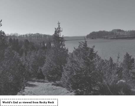
Circumnavigating this small outcropping, the trail undulates gently as it leads to tiny beaches hidden in the curve of the land. As the trail comes around to face north, you get a clear view of the Weir River and the town of Hull on the opposite bank. Looking to the west, you will see the great hourglass-shaped peninsula of World’s End stretching toward Boston.
On Fourth of July weekend, scores of boats tie up here, one to another, displaying scantily clad revelers draped over their decks. In winter, on February’s chilly President’s Day weekend, the waters are empty except for a smattering of eider ducks and seagulls.
The trail comes back around, heading southeast as it reaches the base of Rocky Neck. At each of three forks, bear right, to head south. Dipping through a cedar thicket, the trail soon opens to meadowland. Leave the woods behind and walk uphill to the carriage road. Stepping onto this level, gravel path, head north, keeping the Weir River over your right shoulder.
In John Brewer’s day, horses drew carriages along this route as dark-eyed jersey cows grazed on either side. Today there are no grazing herds, but, for the benefit of raptors, bluebirds, and bobolinks, the fields are mowed to keep them as they were when farmed. Under Olmsted’s direction elm trees once draped branches over the avenue, however, since the Dutch elm disease epidemic, ashes now stand in place of the fabulous shade tree.
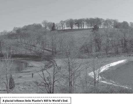
Follow the road as it eases downhill and arrives at sea level. Ahead, look for the glacial isthmus linking Planter’s Hill to the northern tip of World’s End. This spit of gravel and ground shells serves as a handy causeway.
Cross here, taking time for sun and maybe a swim, then follow the carriage road uphill, bearing right. Continuing northward, the carriage road soon reaches a split. When the road forks, proceed straight. This option takes you into what’s referred to as the Valley. Shortly, this path reaches another junction. Turn sharply right and follow the trail as it circles the land counterclockwise. The road rises out of the dark woods of the Valley to lead back to a domed meadow. From here, Hull’s waterfront homes look almost close enough to touch.
Upon reaching the end of the island, the road curves sharply south. This point affords a clear view of Boston. A wedge cut in the tree line and a bench invite hikers to stop for a good look at the city’s skyline and smudged halo.
Continue along the road as it heads south along the western side of the reservation. Hingham Harbor lies to the right through the trees, at the bottom of a steep embankment. Listen for waves washing against the coarse boulders at the waterline. Keep walking beside the harbor when the trail merges with each of two routes coming from the east. Sitting well below the top of a meadow to your left, the trail gradually climbs as it approaches a northern lookout above the causeway.
Having completed the loop around World’s End, make your way downhill to “The Bar” and cross back over to Planter’s Hill. Unless the footpath etched into the face of this steep hill lures you, stay with the carriage road as it continues right. On the peak of the hill, you can find the site of one of the grand elms that once stood in Brewer’s Grove. A stone memorial was placed at the spot to honor F. Arthur Edwards, the last of the Brewer’s farmhands, who died in 1967.
As you gain elevation, the wind eases, and on a biting winter day, the sun suddenly feels a great deal warmer. Approaching the mainland, the road again eases downhill. Ashes tilt across from both sides interspersed with the occasional larch, oak, or linden. Soon, you will see a stone wall on the left, paralleling your path. A little farther along, another stone wall picks up on the right, delineating fields that once held livestock. A few old apple trees hint at what were once productive orchards.
Quiet Martin’s Cove bends in around Pine Hill to the left, and to the right you will see Damde Meadows. A project is under way to restore the meadow to the salt marsh it once was. Walking downhill to a causeway, you will see the tide spilling through from one side to the other. This wetland was previously dammed to add acreage to the farm’s hay fields.
Straight ahead up a rise, you can spot the reservation’s entrance. After the trail splits to the left, leave the cove and climb the granite steps. At the top, you’ll find picnic tables set in a clearing overlooking the salt marsh estuary. Not far beyond, you will pass two outhouses before reaching the lower parking area.
Note: The Trustees of Reservations organizes occasional special events, such as evening owl watches. Horseback riding is allowed; the annual permit costs $100. Leashed dogs are welcome.
NEARBY ATTRACTIONS
Camping is available at Wampatuck State Park, in Hingham. You can help yourself to the healthy waters of Mount Blue Spring, located inside the park. To get there from World’s End take, MA 128 west toward US 3 and turn left onto Free Street.