15 AGASSIZ ROCK HIKE
KEY AT-A-GLANCE INFORMATION
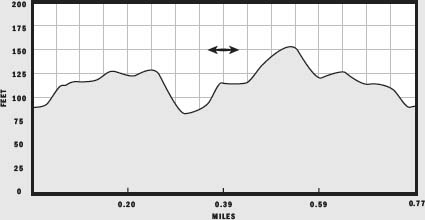
LENGTH: 0.77 miles
CONFIGURATION: Out-and-back with small loop
DIFFICULTY: Moderate
SCENERY: Woods with astonishing glacial erratics and a view of Gloucester from the hilltop
EXPOSURE: Mostly shaded
TRAFFIC: Light
TRAIL SURFACE: Packed earth with exposed roots and stones
HIKING TIME: 40 minutes
SEASON: Year-round 8 a.m.–sunset
ACCESS: Free
MAPS: Posted at the entrance
FACILITIES: None
SPECIAL COMMENTS: Swiss glaciologist and Harvard professor Louis Agassiz was the first to reason that enormous boulders often caught in precarious positions like those found on this hike were moved and arranged on the landscape by sheets of glacial ice.
WHEELCHAIR TRAVERSABLE: No
DRIVING DISTANCE FROM BOSTON COMMON: 30 miles
Agassiz Rock Hike
UTM Zone (WGS84) 19T
Easting: 355035
Northing: 4717726
Latitude: N 42° 35' 54"
Longitude: W 70° 46' 01"
Directions
From Boston, take Storrow Drive East and merge onto US 1 north. Continue on US 1 for 13.6 miles. Merge onto I-95/MA 128 north. Drive 1.3 miles to MA 128 north. Take Exit 15 north and travel 0.5 miles. The entrance is off Southern Avenue on the right. A roadside pulloff will accommodate 10 cars.


IN BRIEF
This short, rugged hike tours a hillside made spectacular by the handiwork of the Wisconsin Glacier. Two granite monoliths are the stars of the show, but wild flowers, streamfed pools and colorful birdlife add plenty of additional interest.
DESCRIPTION
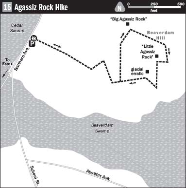
From the gate at the trailhead, follow the broad stony path as it climbs abruptly into the woods. Sweeping southeast, the path meets a stream running from a source high on the hill. A wooden-plank bridge keeps you clear of the wet as you pass a vernal pool sided with granite rubble and adorned with ferns and luxuriant moss. Nestled in a cleft between hills, the trail runs on level ground briefly before beginning its climb. Switching east and northeast over protruding rocks and roots, the path eases downhill and soon arrives at a short causeway with a small pool to the right. Immediately ahead, a sign directs you left to “Big Agassiz” and right to “Little Agassiz.” I chose to take the path to the left.
Heading north under overhanging branches, the trail passes another pool. Continuing on flat ground, step around a grand orb of granite on the right, brushing bayberry bushes as you go.
Curving northward, the slender trail runs downhill through a thick growth of bushes on either side. On the afternoon of my hike, steel-hued thunderclouds rolled onto each other like fighting dogs as heavy weather set in. Word has it that the top of this hill provides an excellent view of Cape Anne firework displays on the Fourth of July. Although Independence Day was weeks away from the look of the sky, I fully expected a brilliant light show within minutes, yet under the trees I felt safe and well-sheltered.
Tumbling through tangled brush, the trail suddenly emerges at a bog. Look to the left and you will see “Big Agassiz” submerged like a happy sow in the soggy ground. Resting in this spot for thousands of years, the rock is said to be far more massive than it appears. Like the iceberg that sank the Titanic, most of Big Agassiz lies hidden.
Through the ages, the curious placement of Big Agassiz and other such boulders was believed to be the work of God, but in the 19th century, Swiss-born geologist Joseph Agassiz convinced his peers and the general populous that ice, not God, was the force at work. By his explanation, this boulder and the others like it that litter New England, are “glacial erratics,” the stranded victims of ice long melted away.
From Big Agassiz, return to the trail, taking it east as it continues upward from the edge of the wetland. Along this part, the trail is surfaced with coarse grit; not yet sand but finer than gravel, that may once have been a part of the famous boulder.
Passing a grove of beeches to the left and hemlocks to the right, the trail steepens as it bends south. Along here, you will see one or two lichen-bedecked boulders; though also glacial erratics, they are not Little Agassiz. Continue until you reach a flat expanse of granite to the left at the top of the hill. Walk out onto this for a look southeast over the tree line to Cape Anne.
Resist thoughts that you have seen all that there is to see, and walk to the right to find Little Agassiz behind another unnamed, but impressive boulder. Propped precariously on a tilted triangular stone, Little Agassiz seems to pulse with potential energy.
After spending some time surveying the view and taking in sun, cloudscapes, or fireworks, pick up the path just below Little Agassiz to the left. Checking the ground, you might spot the tiny columbine that grows from the gritty soil. Blooming in June, its minute flowers are pink with yellow pistils.
After a steep pitch, the trail eases as it returns to the shaded woods. Wintergreen grows profusely along the mossy path’s edge. Soon the incline levels, and the walking gets easier as you arrive back at the junction, where the path bears right to Big Agassiz. Keep left to return to the trailhead at Southern Avenue.