20 MAUDSLAY STATE PARK HIKE
KEY AT-A-GLANCE INFORMATION
LENGTH: 3.92 miles
CONFIGURATION: Loop
DIFFICULTY: Moderate
SCENERY: The grounds of a 450-acre estate designed by the landscape architects Charles Sprague Sargent and Martha Brooks Hutcheson, with views of the Merrimack River
EXPOSURE: Mostly shaded
TRAFFIC: Moderate
TRAIL SURFACE: Packed earth
HIKING TIME: 3 hours
SEASON: Year-round dawn–dusk
ACCESS: Parking $2
MAPS: Available at parking lot
FACILITIES: Restrooms and picnic tables
SPECIAL COMMENTS: The park hosts a full schedule of cultural events in the summer months.
WHEELCHAIR TRAVERSABLE: The path known as the Main Road accommodates wheelchair users; the other trails in this hike do not.
DRIVING DISTANCE FROM BOSTON COMMON: 38 miles
Maudslay State Park Hike
UTM Zone (WGS84) 19T
Easting: 342546
Northing: 4742821
Latitude: N 42° 49' 19"
Longitude: W 70° 55' 34"
Directions
From Boston take Storrow Drive east and drive 1.8 miles on I-93 north/US 1 north, then take Exit 27 toward Tobin Bridge/Revere. Drive 0.4 miles and merge onto US 1 north. After 13.9 miles, merge onto I-95 north. Continue 19.9 miles to Exit 57, toward MA 113 west. After 0.3 miles, turn left onto MA 113 (Storey Avenue). Drive 0.7 miles and turn right onto Gypsy Lane/Hoyts Lane. Drive 0.5 miles and turn right onto Curzon Mill Road. Parking is ahead on the right.


IN BRIEF
On this hike you will explore the former estate of one of Newburyport’s most prominent families. Following trails and carriage roads, the hike takes you through meadows, woodlands, and formal gardens. From the site of the Maudslay mansion, the hike tracks the handsome Merrimack River, following its fast flowing waters north through hemlock woods where bald eagles roost in winter.
DESCRIPTION
From the parking lot entrance, cross Pine Hill Road to the start of Pasture Trail. Hike over the arc of the open field, keeping to the left when the slender path splits. On meeting a gravel carriage path, follow as it descends to the left off a hammock. In summer, yellow splashes against blue as goldfinches dart among lilting blossoms of black-eyed Susan and Queen Anne’s lace growing in the meadow beneath open sky.
Where the trail turns to the northwest, the sun-drenched pasture meets shady woods. On the right is a stand of white pine planted by Frederick Moseley; to the left is a deciduous wood of shagbark hickory, beech, and various species of oak. Where the trail levels, another, less-pronounced path breaks off to the right. Bear left to enter the woods.
Before long, this broad trail reaches a three-way intersection; detour here onto a narrow path sweeping left. At the next fork, bear left again and follow the path downhill, brushing by bushes and sassafras saplings. Ahead, you come to a small footbridge, one of three that Moseley had constructed in 1915. The rhododendrons that envelop you as you stand in this tranquil spot were likely planted in 1926. A diary kept for the estate documents each improvement in detail.
In 1903, married four years and off to a lucrative career in investment banking, Moseley began work on the property he christened Maudsleigh after his family’s ancestral home in England. Intent on replicating the grandeur of British country estates, Moseley turned to the esteemed landscape architect Charles Sprague Sargent of Harvard’s Arnold Arboretum. The men took long walks together to survey the property and discuss its attributes and potential. Then, with a plan in place, Moseley set about reshaping the landscape. He began by planting thousands of white pine on the banks of the Merrimack River, then an avenue of maples along the main road, hedges of spruce and willow, an orchard, and a stand of rhododendrons on the hill behind his home.
Formerly known as Swann’s Cottage, the house and the 11 acres surrounding it was Moseley’s first purchase. Four years later, he bought an adjoining farm and transformed the cottage into a puritanically opulent 72-room mansion.
Traveling as if secretly through boughs of rhododendrons half a world away from the trees’ country of origin, one feels closer to Asia than to the New World. Bit by bit, the dark, fingerlike leaves of the rhododendrons give way to lighter foliage as the path ascends to a fork within a beech grove. Bear left here climbing ascend stone steps to emerge at the eastern end of the Garden Walk.
After his initial consultation with Charles Sprague Sargent, Moseley hired Martha Brooks Hutcheson to design the grounds around the house and several formal gardens. Chances are Hutcheson was responsible for the dramatic border hedge that demarcates this walk.
At the end of this lovely path, you come to a gravel drive and an entryway through an imposing hedge. Slip into the peaceful garden through this passage to reach the spot where Maudslay Hedges, the home of Moseley’s daughter Helen C. Moseley Jr., once stood. Erected by Helen in 1939, the house mysteriously burned to the ground in 1978, four years after her death.
Exit through the hedge and turn right on the gravel drive and right again onto a path heading southeast through an orchard that provided fruit for Miss Moseley’s pies.
Past a spruce hedge, you come to a small granite building that is now shuttered and bears a sign warning of feral honeybees. Ahead, the path leads to the shattered shells of the greenhouses and cold frames F. S. Moseley had constructed in 1900.
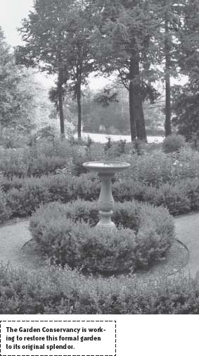
Continue on the gravel road as it curves sharply to the right to reach a formal garden currently being rehabilitated with help from the Garden Conservancy. After taking in the neatly geometric perennial beds and imported marble ornaments, depart through the gate at the far end of the garden. A meadow lies off to the left, as does the well for which the path is named. At the next junction, the path to the left leads to the site of the coachman’s house and barn. To reach the site of the Moseley mansion, continue straight through to a yard of several barns in disrepair and, beyond these, to a sprawling lawn overlooking the Merrimack River. Nothing is left of the house but its lovely view.
In the wake of Helen Moseley Sr.’s death, years after the death of her husband, not one heir was prepared or willing to assume responsibility for the mansion, and so, on the orders of an impetuous son, the fine house was razed.
Having surveyed the site, head toward the river keeping the water to your left, and pick up Merrimack River Trail. At the end of the lawn, a path to the right leads to Rhododendron Dell, reportedly planted in 1903. Staying with Merrimack River Trail, walk beneath the pines and hemlocks growing along the steep riverbank. Linked to the Bay Circuit Trail, which begins at Plum Island and runs through Newbury’s Old Town Hill. Merrimack River Trail spans the length of Maudslay and if plans pan out, the trail will eventually extend to Canada.
Continuing downhill, you soon come to a wooden bridge and commingled mountain laurels. Ahead a swath cut in the laurels affords a view of the river below. Three hundred years ago, looking from here you might have seen Pennacook fishermen netting salmon and sturgeon; today recreational boaters fill the scene. On the other side of the clearing, the trail resumes its course under heavy branches of oak, hickory, and white pine. After encountering two sections of chain-link fence and a concrete dam, the path merges with a packed-earth trail. Climbing the banking, the route leads to a memorial bench.
Merrimack River Trail continues uninterrupted until it reaches Moseley’s Flowering Pond, where it detours to a gravel road. From the road, descend left to a stone bridge and dam at the foot of the pond.
F. S. Moseley undertook several ambitious waterworks projects—one in 1906 to bring plumbing into his house, and others later to provide irrigation to lawns and gardens.
Midway through the estate, Merrimack River Trail reaches Laurel Hill. Watch for the great horned owls and pileated woodpeckers that nest here, and if winter is setting in, keep an eye out for bald eagles. In fact, this trail is closed from November 1 through March 31 to provide peace and protection to a number of these spectacular raptors, that retreat from Canada to this spot every year. Frederick’s father, Edward, purchased much of Laurel Hill in 1860 to preserve the delicate habitat.
From the eagle’s roosting grounds, stay with Merrimack River Trail until it reaches a broad fork. At this juncture, proceed left up a rocky slope to arrive at a large intersection.
Stay on the river until the trail arrives at an avenue of sugar maples ascending in a regal line to the top of Castle Hill. Back in the 1600s, a man named William Moulton settled these acres and earned a fortune mining silver along the river. In 1860, his descendant Henry Moulton acquired the hillside and built a gothic castle of wood on the highest point. In 1896, Charles Moseley gained possession of this parcel and in 1900 tore the castle down.
From the castle’s footprint, follow the gravel road as it corkscrews around the other side of the hill. Arriving at the bottom, make a hairpin turn to take up a westward trail on the right. Look for engaging eyes staring through the woods from the dairy goat farm across the way.
The trail forks twice in quick succession; hike right at the first split and left at the second to travel downhill on a gravel carriage route under a canopy of hemlocks. Pass through the next junction to continue straight on this path, which is aptly named Cathedral Road. Stay on Cathedral Road through each four-way intersection and upon arriving at a fork, hike downhill to the left. Soon after this junction, the trail reaches yet another split; continue straight, and at the next fork bear left. Proceed straight on the wide carriage path. Before long you will see a sign that reads “parking,” with an arrow pointing to a trail to the left. Resisting this direct route to the parking lot, bear right. In a moment, this road passes a narrow footpath running off into underbrush to the left. This, too, will take you back to the start. But, for the pleasure of crossing the eastern end of the Flowering Pond by way of a magnificent stone bridge, stay on the gravel carriage road. Referred to as Main Road, this route promptly reaches a T-intersection. Travel straight on to rejoin Pasture Trail and retrace your steps back to the parking lot.