21 WARD RESERVATION HIKE
KEY AT-A-GLANCE INFORMATION
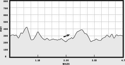
LENGTH: 4.7 miles
CONFIGURATION: Loop
DIFFICULTY: Easy to moderate
SCENERY: Farmland reverted to woods, centuries-old abandoned cart roads, solstice stones, and a rare quaking bog
EXPOSURE: Mostly shaded
TRAFFIC: Light
TRAIL SURFACE: Grass, packed earth, and an occasional boardwalk
HIKING TIME: 3–3.5 hours
SEASON: Year-round 8 a.m.–sunset
ACCESS: Free
MAPS: Available at the entrance
FACILITIES: None
SPECIAL COMMENTS: The Ward Reservation offers visitors great variety. For those with children or limited time, an interpretive trail along a 700-foot boardwalk through a fascinating quaking bog provides a satisfying shorter hike. Especially intrepid ramblers might consider linking from here to the Mary French Reservation and onward to the Harold Parker State Forest by way of the Bay Circuit Trail.
WHEELCHAIR TRAVERSABLE: No
DRIVING DISTANCE FROM BOSTON COMMON: 25 miles
Ward Reservation Hike
UTM Zone (WGS84) 19T
Easting: 326825
Northing: 4723082
Latitude: 42° 38' 26"
Longitude: 71° 06' 44"
Directions
From Boston take Storrow Drive east staying to the left; after 0.3 miles merge onto I-93 north. From I-93 north, exit onto MA 125 north and go 5 miles. Turn right onto Prospect Road and follow it 0.3 miles to the reservation entrance; there is a parking area on the right.

IN BRIEF
Touring a 700-acre parcel of former farmland and forest, this hike begins with a hike up Holt Hill for a view of Boston then rounds Cat Swamp switching from footpaths to cart roads and back again to ascend Boston Hill then arc back to the Ward family’s farmstead.
DESCRIPTION
Established in 1940, the Ward Reservation is a stunning example of the ongoing success of the landscape architect and conservationist Charles Eliot and his ambition to preserve New England’s open space. Initiated by Mabel B. Ward’s gift of 153 acres to the Trustees of Reservations, the reservation grew to 700 acres as private individuals made similar gifts. Over several decades, 40 separate parcels were united, preserved, and made available to the public for passive recreational use.
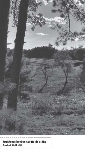
Look for the trailhead to the left of the kiosk and set out heading south toward the bog at Pine Hole Pond, crossing a grassy meadow next to a house on the left. Where the path approaches woods, a sign reads “X-country ski trail, follow orange markers.” Hike left here to climb a steep hill overlooking the bog. After a steep ascent, the trail runs along the edge of a sloping apple orchard.
At the orchard’s end, continue through a wide gap in a ramshackle stone wall and cross the gravel drive to a rounded hayfield spread before a clutch of houses. Bear left across the grassland to a valley on the hill’s eastern side. Approaching the edge of the woods, two trailheads become visible; aim for the one farthest to the left and follow it on its meandering markerless course to another stone wall.
At the wall, a sign states that on the other side of the wall, the orange trail splits to the right and the Bay Circuit Trail continues straight on to the summit of Holt Hill. It’s worth noting that the Bay Circuit Trail, in making its arc around Boston, is always identified by white trail markers; but on the Ward Reservation map, the Bay Circuit Trail is marked in green and is referred to as “the green trail.”
From the stone wall, the Bay Circuit Trail bends northwest toward a farmhouse built on a verdant cleft in the hill. Reaching an elevation level with the homestead, the trail arrives at a three-way junction distinguished by an epic birch tree. Parallel stone walls run due east from the spot, with two trails traveling in their shadows. One of these, the Bay Circuit Trail, identified with green blazes, tracks the topmost wall briefly before veering north to girdle the hillside. Take this route as it curves through woods of monumental pines to approach Holt Hill, briefly winding eastward before taking the hill head-on. Though the well-trod path is easy to follow, the ascent is sudden and sharp.
Besides being a good test for the heart and lungs, Holt Hill’s 420-foot elevation, with its bald southern face, boasts wonderful views of Boston and the Blue Hills. On June 17, 1775, settlers climbed to this vantage point to witness the raging fire in Charlestown set by British soldiers on orders of General Howe during the Battle of Bunker Hill.
Mabel Ward’s solstice stones, arranged to mark the path of the sun on the longest and shortest days of the year—the summer and winter solstices—and at the spring and autumn equinoxes, also add interest.
From the solstice stones, hike 100 yards farther north to the imposing fire tower, then, following a stone wall on the right, locate a trail leading back into woods. On a sunny day, the transition from the heat and bright light of the hilltop back to the damp cool of shade cast by oaks and pines is jarring. That the trail plunges straight down the hill’s dark northern face toward the mysterious Cat Swamp only heightens the contrast in mood.
Upon reaching the swamp, the connector trail forms a “T” with the Sanborn Trail. Turn left at this junction and continue along the base of Holt Hill, heading west. Gradually, the trail leaves the wetland to wind around the hill’s more benign western slope and to reascend the peak.
Reemerging from the woods to find a paved access road to the hilltop reservoirs, turn right and following Bay Circuit Trail markers southeast a short distance to where this route joins a trail heading into the woods on the right. Change course here to follow a stone wall northeast. Along this approximately 0.3-mile section of sloping rocky terrain, the trail crosses the wet periphery of Cat Swamp. Past a boardwalk and after a brief climb, the trail reaches a three-way intersection.
Two trails bend off to the left. One is the Bay Circuit Trail; the other, making a tighter turn, is a 0.4-mile route back to the parking lot. To continue on the tour of the reservation, opt for the path to the right, Margaret’s Trail.
Traveling northeast on level ground, Margaret’s Trail parallels a wetland rife with beavers and vocal waterfowl. Upland rises beside it to the right. In autumn, the smell of apples wafts in the air, probably from orchards now overgrown by pine and sassafras. Turning away from the wetland, the trail arrives at a three-way junction. Take the path identified as “the shortcut to Chestnut Street” on the right, which serpentines to its promised destination.
Lined by two robust stone walls, Old Chestnut Street cuts a near-straight north–south line through former pastureland. Much of this ancient road, named for the tree that once flourished in this woodland, is still in active use beyond the reservation’s borders, but the section within the property was abandoned in 1933. Access this still-impressive cart road by bearing right through a gap in the upper stone wall.
After crossing a stream, Old Chestnut Street meets the Sanborn Trail dropping in from the right off of Shrub Hill. Passing a valley on the left as it climbs the side of this hill, the cart road soon arrives at a crossroads. Leave Old Chestnut Street here, turning left onto Graham’s Trail and hiking east toward Boston Hill. At the next split in the trail, which comes quickly on a rise, stay to the left on Graham’s Trail. After climbing a bit farther to another junction, continue to the right, to continue your ascent. Laminated directions posted at junctions along here confuse more than they enlighten; so you are better off ignoring them To proceed, stay on Graham’s Trail, following it southeast. When Graham’s Trail itself becomes vague, arrows point the way.
Curving around the top of Boston Hill, the trail passes a lovely vantage point above a meadow on the hill’s western face. Have a look, then continue east alongside a stone wall and a wire fence to a second meadow on the hill’s eastern side.
Lying several yards ahead amid goldenrod, the seed heads of grasses, and purple asters is the curious glacial erratic named Elephant Rock. Angular yet rounded, eyed through a squint, the boulder does resemble an adolescent elephant in the sun.
Take in the view looking south toward the City of Boston then hike down the hill, passing a service road, to a dense grove of birch saplings. Approaching the base of the hill edged by a stone wall, the trail meets another route merging from the right. An ancient birch, perhaps an original property marker, stands steadfast here in a corner formed by two stone walls. At this spot, the trail veers left to run along the outside of an abandoned walled-in avenue.
Ahead, the trail crosses a broad stream via a boardwalk and, after navigating a series of stone walls, climbs gently to connect with Old Chestnut Street. Bear left on this familiar avenue and continue several hundred yards to another trail, well marked with an arrow, branching off to the right.
Pass another path that splits northward, and if the sun is low, keep an eye out for deer attracted to a nearby spring. Climbing away from the wetland, the trail skirts private property. Shortly, where it splits again, arrows point the way. Somewhat sketchy now, yet sufficiently marked, the trail brushes past an enormous oak tree that, judging from planks nailed to it, doubles as a lookout.
A few feet farther, at a junction, a sign directs hikers right to the summit of Holt Hill and left to Prospect Road. Choosing the path to the left, ease southeast along the hillside that tapers downhill past a convergence of stone walls to join up with an old cart road. Striding up the last rise, imagine men clucking at teams of horses and oxen, cracking whips to urge them on to the homestead just beyond. Once back where the Bay Circuit Trail marches up Holt Hill, follow the trail left and retrace your steps to the parking lot.