24 GOLDSMITH WOODLANDS LOOP
KEY AT-A-GLANCE INFORMATION
LENGTH: 3.67 miles
CONFIGURATION: Loop
DIFFICULTY: Easy to moderate
SCENERY: Woods, wetlands, and a large pond
EXPOSURE: Mostly shaded
TRAFFIC: Light
TRAIL SURFACE: Packed earth, gravel, and boardwalk
HIKING TIME: 1–1.5 hours
SEASON: Year-round sunrise–sunset
ACCESS: Free
MAPS: Andover Village Improvement Society (AVIS) maps can be purchased at the Andover town hall and at Andover’s sports outfitter, Moor & Mountain, at 3 Railroad Avenue, (978) 475-3665.
FACILITIES: None
SPECIAL COMMENTS: Though short in miles, Goldsmith Woodlands Loop is long in interest. Be sure to allow enough time for birding, botanizing, and, if the season is right, blueberry sampling.
WHEELCHAIR TRAVERSABLE: Zack’s Way, which leads from the parking area to Foster’s Pond, is rough but passable.
DRIVING DISTANCE FROM BOSTON COMMON: 22 miles
Goldsmith Woodlands Loop
UTM Zone (WGS84) 19T
Easting: 325803
Northing: 4719767
Latitude: N 42° 36' 38"
Longitude: W 71° 07' 26"
Directions
From Boston, take Storrow Drive east and merge onto I-93 north via the ramp on the left toward Concord. At 16.5 miles, take Exit 41 to MA 125 toward Andover. Continue 0.3 miles and keep right at the fork to access MA 125. Drive 2.3 miles and take the MA 28 north ramp. Merge onto MA 28 and drive 0.3 miles. An AVIS sign marks the entrance to the parking area on the left.


IN BRIEF
This hike explores the fabulously glaciated woodland landscape surrounding a large pond named for one of Andover’s first settlers.
DESCRIPTION
In 1634 the Great and General Court of Massachusetts set in motion the establishment of an inland plantation northwest of the already burgeoning settlement of Boston. To encourage colonists to leave the comfort and security of the coast for the wild, wolf-ridden frontier, the court offered the first settlers three years of immunity from taxes, levies, and services—except military obligations. Thus encouraged, Andrew Foster and another 21 game individuals from Newbury and Ipswich ventured forth and, together by pooling resources that amounted to six pounds currency and a coat, they transacted a land deal with Chief Cutshamache of the Pennacook.
According to the evidence, Andrew Foster won the gamble for after amassing a sizable parcel of land—including the pond that now bears his name. He lived to the remarkable age of 106. His widow, Ann “Goody” Foster, fared not nearly so well. During the madness of the Witch Trials of 1692, she and her daughter Lacey were called before the judges. Lacey survived, but Ann, who sacrificed herself to save her daughter, was condemned and died during her 21st week in jail.
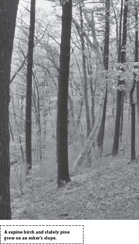
From the trailhead at the far end of the parking area, set out hiking west on Zack’s Way, a level path the width of a farm cart. Easing downhill alongside a brook past a kiosk and AVIS signs, this even, old-time service road nests on a banking beneath rock, sand, and gravel shoved high by glacial ice 10,000 to 12,000 years ago. Ahead, where Zack’s Way swings left, bear right on the High Trail to ascend a great ridge rimming wetland to the north. Dark, steeple-straight pines varied with lissome birch veil the view of the gurgling waters of Frye’s Brook far below.
Edged for a brief while by a slapdash or weatherworn stone wall, the trail traces the ridge west, passing an unmarked path to the left before leaving the stone wall and descending to a clearing on the shore of an old millpond.
Steer left, taking up the Pine Trail, which joins in off the hillside and travels south keeping within sight of Foster’s Pond and its swampy border.
Rolling over gentle dips and swells through mixed woods accented with young aspen, the trail soon rises to a broad junction cut into a stand of black pine. Noting Zack’s Way entering from the left and a new trail, make a beeline for the pond by heeding the sign for Bessie’s Point.
Sloping downhill on a gentle grade, the path quickly dovetails with another (Meeting House Road) then carries on through an avenue of black pine to an elevated enclave rich with rhododendron and laurel planted a century or so ago. Landowner Bessie Goldsmith, kept house on this peaceful hummock in a rough-hewn cabin through World War II, the psychedelic 1960s, and the Nixon presidency.
Cast of a mold all her own, Bessie is said to have been more than a little possessive of her blueberries in picking season. Any trespasser she caught harvesting was met with a shotgun pointed at their bucket. Though indeed strong in her convictions, Bessie was not ungenerous—in 1974 she entrusted her entire property, blueberry bushes and all, to the Fund for Preservation of Wildlife and Natural Areas.
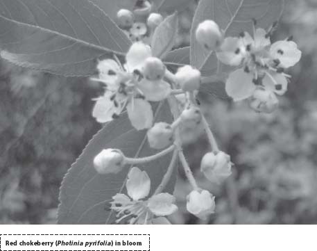
From the crest of the hillock where Bessie’s cabin once stood, follow the trail as it tapers to a slender spit of moss-covered rocks sleeved in high-bush blueberries and honeysuckle. Water lies all around, rippling with life forms peculiar and spectacular—from polliwog and water strider to wood duck and painted turtle.
To continue the hike, reverse direction and ascend the steps to a bench beside Bessie’s homesite; when ready, retreat on Meeting House Road. Bearing right at the junction encountered earlier, stay with the cart road as it leaves the pines behind and enters a wood of oak and maple to soon arrive at a crossroad. Here a sign alerts passersby to the former location of Zack’s cottage on the right and, kitty-corner to it, his hop pit. Zack likely never met with the butt of Bessie’s shotgun since Bessie employed him as a caretaker for the woods and as a seasonal handyman in the summer months when she rented out cottages to vacationers.
After surveying the cellar hole of the cottage where Zack once tucked into hearty meals and kicked up weary feet for a good night’s sleep, follow the “new path” (Pond Road) west back toward Foster’s Pond. After meeting with a path to the left, this rutted cart road bears north and rolls downhill rounding a shrub-hidden bend or two to meet the water’s edge at Wind Landing. In spring, amid the raucous cackling of red-winged blackbirds and black-purple grackles, keep an eye out for blossoming lady’s slippers.
To vary the route on the return trip, split to the right when the trail forks and hike along the pond’s steep banking to loop back to Pond Road, heading east again.
On returning to Zack’s house, turn right and follow Al’s Trail south, first downhill then across a causeway between wetland and Foster’s Pond. Don’t be turned away by the chain—its purpose is to bar vehicles not hikers. Opposite a path that ventures up a steep rise pond-side, the trail travels past meadowland fringed by woods to the east. Once around a weedy cove settled by wood ducks, the trail ascends into a hemlock grove arcing high and wide of the water to follow an earthen finger to “Journey’s End.”
From the peninsula’s narrow point, backtrack to a path branching to the left and follow its lead across a boardwalk to the tiny island of Point Judith. After some bird-watching or picnicking, follow the path as it crosses to another oblong island via boardwalk and loops back to the hemlock wood.
Aiming southeast now, retrace steps over Al’s Trail past Birch Cove back to the junction at Zack’s house—detouring to the left along the way for one more gander across the pond. Turning from the pond, pass Zack’s hop pit and follow Pond Road (marked “New Trail”) as it dives eastward. Continuing over and through great swells and swales, the trail swerves west at a brook then converges with the level plane of Zack’s Way. At this triangular junction, bear right and follow the sandy cart road east back to the reservation’s entrance and parking lot.
NEARBY ATTRACTIONS
Those interested in extending their stay in Andover might like to camp at the nearby Harold Parker State Forest. The park 91 campsites and, most importantly, hot showers. The campground is open from mid-April to mid-October. Trails in the 3,000-acre park connect with the Skug River hike and the Bay Circuit Trail. The state forest is at 1951 Turnpike Street, Route 114, North Andover, (978) 686-3391.