28 WILLOWDALE STATE FOREST: Pine Swamp–Milldam Loop
KEY AT-A-GLANCE INFORMATION
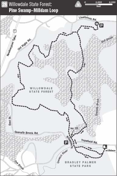
LENGTH: 7.6 miles
CONFIGURATION: Loop
DIFFICULTY: Easy to moderate due to the length
SCENERY: Woods, kettle ponds, vernal pools, the Ipswich River, a fish ladder, and a 19th-century milldam
EXPOSURE: Mostly shaded
TRAFFIC: Moderate
TRAIL SURFACE: Mostly packed earth and gravel and potentially muddy areas
HIKING TIME: 3 hours
SEASON: Sunrise–sunset year-round
ACCESS: Free
MAPS: Available at www.mass.gov/dcr/parks/northeast/wild.htm
FACILITIES: None
SPECIAL COMMENTS: Deer ticks are common in these woods; be sure to check yourself and your clothes for hangers-on after hiking. Also note that hunting is allowed in November and December.
WHEELCHAIR TRAVERSABLE: Bradley Palmer State Park has wheelchair-friendly trails.
DRIVING DISTANCE FROM BOSTON COMMON: 31 miles
Willowdale State Forest
UTM Zone (WGS84) 19T
Easting: 344581
Northing: 4727597
Latitude: N 42° 41' 06"
Longitude: W 70° 53' 50"
Directions
From Boston, take Storrow Drive east toward I-93 north, then merge onto US 1 north toward the Tobin Bridge. Drive 15.1 miles and merge onto I-95 north. After 3.7 miles, take Exit 50 (toward Topsfield) to US 1 north. At 6.8 miles, turn right onto Linebrook Road, Ipswich. Continue about 1.3 miles. The parking area is on the right at the bottom of a hill before Marini’s Farm stand (259 Linebrook Road).

IN BRIEF
This hike explores the Pine Swamp of the popular Willowdale State Forest, taking a detour halfway through to travel along the Ipswich River to a scenic 19th-century milldam.
DESCRIPTION
Something about the Ipswich River and its rugged, placid, and fertile watershed attracts ambitious men with expansive appetites. Its first “owner” in recorded history was Chief Masconomo of the Agawam. The next was John Winthrop—son of Massachusetts’s first governor. The last was Bradley Palmer, a Harvard-educated lawyer, who, besides representing Sinclair Oil in the Teapot Dome scandal, served President Wilson at the Versailles Peace Conference in the final days of World War I. Bradley Palmer’s holdings were likely the smallest—just 10,000 acres spread over five towns. Perhaps the soul of Masconomo, who was said to have been a wise and generous man, still watches over the land. It’s a curious notion but one that would explain what moved Bradley Palmer to donate all his vast acreage to the Commonwealth of Massachusetts well before his death in 1948.
From the parking area on the side of Linebrook Road, navigate the green steel fence and hike south on the mowed path to the left of a cultivated strawberry field. Sloping to the edge of the farmland the trail divides in two as it reaches shade. Heed white markers for the Bay Circuit Trail and enter the woods via a prominent esker bridging wetland. Hardwoods, mostly oaks and hickories, nod in from the sides as the ridge of sand and gravel eases to lower ground. Except for the filtered sound of cars traveling on US 1 a couple of miles away, there is little to hear but buzzing insects, woodland birds, and the crunch of your own footsteps.

A stone wall plods in from the right, meeting the broad trail as it travels west, gently undulating to a triangular crossroads marked “24.” Stay to the right, and continue hiking west to junction 25. Here, pick up a wide cart road heading southwest. Soon, the monotonous swish of the traffic vanishes into the pines. Sloping to more wetland, the woodland road flattens and narrows precipitously as it nears the next intersection (which may be number 26 but is unmarked). Choose the route to the left and continue southwest, passing a rough-and-tumble fragment of stone wall. Guided by parallel stone walls, the cart road passes through reforested farmland to reach junction 27.
Bearing right the trail begins climbing, swings west, and keeps climbing to arrive at another junction. Far out of numerical sequence, this intersection is marked 37. Here, the cart road exits to Old Right Road, which lies to the north. A less-used and narrower footpath splits off to the left. Take this route to continue south hiking over rounded hillocks straight through junction 38. Ahead, a wetland basin rife with pine lies at the foot of upland. At junction 39 leave the primary trail, blazed with small blue and red markers, and hike left, bearing closer to the wetland. Rapidly filling in with frilly white pine saplings and bushy ferns, this moist enclave of formerly cleared land is an ideal environment for deer. Guided by a brook the trail bends gradually northwest to reconnect with the trail from which it diverged earlier. At this unmarked juncture descend a slope heading southwest to a causeway spanning the brook’s overflow.
Atop the opposite rise the trail arrives at junction 41. Continue straight to reunite with the Bay Circuit Trail as it comes rolling in from the east on another broad cart road at junction number 10. Picking up with this long-distance traveler, aim for its white markers posted across the way, and hike west through the next junction (11) to a large pond nested in bogland brush. Destined for Hood Pond in Boxford, the Bay Circuit Trail rounds the swamp and directs itself to the Topsfield–Ipswich town line.
Depart this trail at junction 12 and hike south a few hundred yards farther to a broad four-way intersection that is missing a marker (but is likely number 29), and hike left. Following a stone wall up and over a modest hill, the route travels along a broad avenue through uncluttered woods of beech and pine to arrive at junction 45. Continue straight (east) through this crossroads and the next, gradually curving north to reach junction 33. Bear right, away from Pine Swamp, to follow an expansive trail edged with sweet-smelling ferns over languorous contours to junction 35. Deviate from this southeastern trajectory briefly to hike north to a deep-woods version of Grand Central Station. At this junction (6), the Bay Circuit Trail sweeps in from the northeast, jackknifes, and continues on its 200-mile journey around Boston.
Quit the Bay Circuit Trail, turn right onto a cart road, and travel 0.4 miles to the western border of Willowdale at Topsfield Road. The trail continues across the road at Bradley Palmer State Park. Wait for a lull in traffic then cross to continue the hike. Several yards in, concealed by a curtain of hemlocks, a sturdy wooden bridge arches across the Ipswich River. Running 45 miles from its source in Wilmington to the Atlantic at Ipswich Bay, the Ipswich River today provides 350,000 people with drinking water. Wasting no time upon discovering this handsome river in 1638, John Winthrop shrewdly negotiated with Chief Masconomo to sell him the lands along it—together with exclusive fishing rights—in 1638. The price: 20 pounds sterling. Nearly four centuries later, Winthrop’s Arbella Farm is still in the hands of the Winthrop family and remains largely intact.
On the far side of the river, by a Hamilton Conservation Commission sign, a trail diverges left. Turn here and follow blue paw-print trail blazes to trace the river’s course eastward. Gouged and grated by glacial ice 10,000 years ago, the river lies like a black racer in the shade of a steep banking that looms from the south. Little but hemlocks grow along this heavily contoured edge made soft by their detritus. The only indication of the granite bedrock is the sand and grit lining the root-riddled trail.
On any given day, especially sunny ones, turtles line up nose-to-toe on fallen trees lying in the water. Night hunters, like raccoons, skunks, and fishers, keep well hidden during the day but leave plenty of evidence of their comings and goings. An occasional path splits off to climb away from the water, but stay with the blue trail on its riverside run to reach a dam built for a textile mill in the early 1800s. The mill turned out woolen blankets and stockings for half a century until an all-consuming fire put an end to the enterprise. Today, the mill site and old sluiceway stretching from the dam to Winthrop Street is held under the protective ownership of the Essex County Greenbelt Association.
While exploring the dam, have a close look at the fish ladder constructed beside it. From as early as April to sometime in June, daring alewives and herring, all but exhausted by their Atlantic exodus, leap from one step to the next, using all their might to reach still waters. Mature American eels migrating back to the Sargasso Sea use the ladder in autumn. Returning to ocean spawning grounds they leave equipped with newly formed fins and enlarged eyes—adaptations required for life at sea.
From the milldam hike away from the river on a path heading uphill past marker 10 to make a loop back to the park entrance. After a pulse-quickening climb the ground levels, and soon the trail arrives at junction 9. Take the wide grassy avenue to the right and continue southwest. As the route is both a hiking trail and a jumping lane for equestrians, don’t be surprised to hear the beat of cantering horse hooves.
Follow this trail only a moment, then bear right onto a narrower path that ventures back into the woods. Light reflecting off the water jabs at the staid evergreens as the path passes high above the river. Odd strands of stone wall appear now and again as the path makes its way through the open understory to the trail that leads back to the bridge across the river.
Resuming the Willowdale Trail hiked earlier, retrace your steps to junction 22. Leave the cart road here and take up this narrower trail heading east. The outer reaches of the enormous Pine Swamp creep in from the left. Lifted above the wet by a natural and enhanced causeway, the trail runs on a plane through junction 32 and straight on to meet another cart road at junction 21. Turn left here to travel north across Gravelly Brook and the untamed wonderland of its floodplain.
Ahead, a fork presents an opportunity to venture from the cart road onto a less-traveled path. To feel closer to the woods and their inhabitants take this right. A few hundred yards ahead, the two paths meet again and the cart road continues on to junction 20. At this disorientating intersection, hike left and then straight ahead at the next split to reconvene with the Bay Circuit Trail, traveling north.
Managing to stay dry as it traverses swamp, the trail crosses a culvert here and there and winds past pools teeming with life. Frogs chirp as they leap out of the path where they have been sunning themselves or hunting insects. Bowing to the west and then east, navigating the swamp by misaligned hillocks, the wide, flat trail eventually straightens and climbs from the swamp. Ascending an extended gravel slope, the trail passes several others diverging from it, and finally returns to junction 24. Having come full circle bear right and follow the familiar trail through the woods to Marini’s strawberry field and Linebrook Road just beyond.

NEARBY ATTRACTIONS
After this long hike it is likely you will be ready for a bite to eat. If so, seek out The Clam Box restaurant close by at 246 High Street in Ipswich. Custom built in 1938 by Mr. Greanleaf to resemble an actual clam box, the eatery serves a full menu of fried freshly caught seafood. Their hours vary, so it is advisable to call before stopping by, (978) 356-9707.
Foote’s Canoe Rentals, located opposite the milldam, has canoes to rent by the hour and by the day and will even organize overnight trips. Call for more information, (978) 356-9771; www.footebrotherscanoes.com.