31 BEAVER BROOK HIKE
KEY AT-A-GLANCE INFORMATION
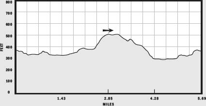
LENGTH: 5.69 miles
CONFIGURATION: Loop
DIFFICULTY: Easy to moderate
SCENERY: Forested wetlands, beaver ponds, and views of sustainable forestry in action
EXPOSURE: Mostly shaded
TRAFFIC: Light
TRAIL SURFACE: Packed earth, wooden footbridges, and some rugged, rocky areas
HIKING TIME: 2.5–3 hours
SEASON: Year-round sunrise–sunset
ACCESS: Free
MAPS: Available online at www.beaverbrook.org/bbtmaps.htm, and at the Beaver Brook Association’s office at 117 Ridge Road, Hollis, NH, open Monday–Friday, 9 a.m.–5 p.m., and Sunday, 10:30 a.m.–3:30 p.m.; closed Saturday.
FACILITIES: None
SPECIAL COMMENTS: The Beaver Brook Association manages a cabin facility that accommodates up to 22 people—two bunkhouses, a cookhouse, a well house, a campfire circle, and a primitive latrine.
WHEELCHAIR TRAVERSABLE: No
DRIVING DISTANCE FROM BOSTON COMMON: 50 miles
Beaver Brook Hike
UTM Zone (WGS84) 19T
Easting: 285404
Northing: 4734547
Latitude: N 42° 44' 01"
Longitude: W 71° 37' 17"
Directions
From Boston take Storrow Drive east to I-93 north. After 5.4 miles, merge onto I-95 south/MA 128 south via Exit 37B toward Waltham. Take the US 3 north/Middlesex Turnpike Exit 32B-A. Merge onto US 3 north via Exit 32A toward Lowell/Nashua, NH, and continue 27.1 miles. Take the Broad Street Exit 6 toward Hollis, driving 0.2 miles. Bear left to take the MA 130 west ramp toward Hollis/Brookline, driving 0.1 mile, and turn left onto Broad Street/NH 130. Pass through one roundabout and continue 5.4 miles. Turn right onto Ash Street/NH 130. Continue to follow NH 130 to the sign for the Beaver Brook parking lot on the right (note that you will first pass another Beaver Brook parking lot on the left).

IN BRIEF
Located just over the Massachusetts/New Hampshire border, the Beaver Brook Preserve presents a landscape where beaver abound and loons or even a wandering moose wouldn’t come as a big surprise.
DESCRIPTION
Like many conservation projects, the 2,000-acre Beaver Brook Preserve exists because a small group of individuals with a passion for the environment got an idea and acted on it. It all began in the early 1960s when two cousins, Hollis Nichols, a Boston mutual fund manager with a powerful love of nature and the outdoors, and Jeff Smith, a farmer, forester, horticulturalist, and already active conservationist, put their heads together and founded the Beaver Brook Association. The first donated parcel was 17 acres surrounding a house Nichols had built for his mother. Nichols possessed the resources and financial expertise to get the project off and running, and Hollis native Jeff Smith, who had been a town selectman and member of the conservation commission, knew the community and its eligible property.
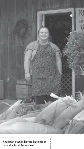
Today Beaver Brook is composed of 90 separate parcels located in the Merrimack River watershed, most of which lie in the town of Hollis; an additional 200 acres lie in neighboring Milford. Invested in more than conserving land and protecting wildlife, the Beaver Brook Association runs a model sustainable farm, educational programs for children, public festivals, and horticultural classes. All told, the overarching goal is to demonstrate how forestry, recreation, and wildlife can thrive side by side.
From the notice board located in the right corner of the parking lot, hike north on Wildlife Pond Trail. Passing through woods along a stone wall. Starting out wide and level, the path soon reaches a junction, where it splits in two. Take the path on the right to join Wildlife Pond Trail; marked with yellow diamonds.
Becoming narrower, the trail dips and bends over soft ground riddled with roots to reach the southwestern end of Wildlife Pond. Turning eastward, briefly leaving the bank, the trail returns to the water’s edge, and what first appears to be a modest pond is revealed to be something more. Greatly elongated, this magnificent pond stretches on and on.
Five hundred feet ahead, Wildlife Pond Loop Trail is bisected by Old City Trail, which runs to the northwest. Crossing Route 130, this trail links the northern and southern halves of Beaver Brook.
Rising from the water just past this junction is a Taj Mahal of beaver lodges. Beyond this tooth-wrought architecture, the trail leads to a bench arranged on a mossy nub of turf. Stop here to scan the watery landscape for a moose, a flashy wood duck, or a heron standing in shallows like a frozen shaft of lightning.
Winding onward Wildlife Pond Loop Trail encounters a path to the right and a small footbridge. Mountain laurels add elegance, and the plump fruit of well-irrigated high-bush blueberries incite greed as the pond reaches northward. Close by, too, is another beaver lodge similar in size to the first. Finally, rounding the slender tip of the pond, the trail turns and traces the opposite bank to its western end. Yellow-flowered lily pads grow densely on this murkier side, and flycatchers swoop from drowned trees to chase damselflies.
Short of completing the loop around the pond, the trail veers away from the wetland into a hemlock wood. A few yards farther, after a stone wall interrupts the trail, the path rejoins Old City Trail. Turn right toward upland here to hike along a wide logging road. Climbing on a slight grade between stone walls, the dirt road cuts through a forest thinned over time of its choicest lumber. White pine and hemlock dominate with hardwoods poking through here and there.
At about 0.3 miles, the trail comes to what a posted notice identifies as a fullscale prototype for a portable skidder bridge. As the notice explains such bridges promote sustainable timber extraction by protecting rivers and streams from wear and tear and from contamination caused by eroded soil and other waste.

Passing the skidder bridge, the blue-marked Old City Trail proceeds along a sliver of land between the wetland bordering Rocky Pond Brook to the right and rugged upland to the left. Leafy mountain laurel thrives on both sides and hemlocks tilt at odd angles, tightly grasping the granite ledge which creeps to the swamp.
Not far along this dramatic passageway, Old City Trail passes Rocky Ridge Trail, which cuts to the left. If a shorter, steeper hike has more appeal than a longer but less strenuous one, head west here; otherwise, continue north on Old City Trail. Soon crossing a wooden bridge, this trail runs along the brook. Basswood trees, maples, and aspen do a good job of hiding the action in this wetland, but through breaks in the foliage you might catch a glimpse of a resident kingfisher squawking in the high branches or diving for trout fingerlings.
Where the trail begins to sweep northwest, a notice alerts visitors that in August 2005 acreage on both sides of the trail was given to the Beaver Brook Association by Debra Worcester Hildreth in memory of her father, John Worcester. A century ago, the Worcester Brother’s Mill located upriver off Rocky Pond Road, fueled its business with timber cut from this forest. Old City Trail continues north to the millpond and the site of the Worcester Brother’s milling operation.
At a junction farther on, take Rocky Pond Trail to visit the nearby mill, or turn left onto Tupelo Trail. Immediately crossing a bridge, this trail heads southwest, narrowing as it ascends a moderate grade, and passes plentiful mountain laurel.

Nearing the top of the hill, the trail skirts a tract where the effects of logging are more obvious. Fueled by increased sunlight, grasses and shrubs have gotten the upper hand, to the benefit of deer and songbirds. A chestnut oak or two grow where the trail crosses a logging road and levels off. The commercially desirable tupelo trees, for which the trail is named, were undoubtedly heavily logged.
Making its way downhill between stone walls, the trail passes above Heron Pond and, moments later, opens to a wide triangular intersection amid pine and oak. Continue straight, heading southwest. As I hiked on a September afternoon, the lemony smell of witch hazel drifted on the breeze as rain clouds rolled in.
Behind the hill in a choice resting spot, a throng of granite chunks sits just off the trail like weary bystanders. Hereafter, the incline shifts decidedly downhill. Winding eastward, the trail soon arrives at another intersection. Take Mary Farley Trail on the left for a shortcut back to Wildlife Pond, or follow my lead and bear right onto Wood Duck Pond Trail.
Marked with blue, this wide path tapers unhurried to wetland. In autumn amanitas shaped like goblets, and honey mushrooms feeding on eroded life poke out from the dark humus. After passing a glade on the left, the trail dips then rolls steadily downhill past young beeches.
Settling onto level ground in view of the twin Wood Duck Ponds, the trail makes a “T” upon meeting Jeff Smith Trail. Marked with yellow, this new trail emerges from between the ponds to the right and heads abruptly eastward. Whatever the season, the pond detour on Jeff Smith Trail is highly recommended.
Having been coaxed back to life by Beaver Brook Association volunteers, the Wood Duck Ponds are always beautiful—even in the smudgy gray light of an impending storm. In dim light, the red blossoms of cardinal flowers (Lobelia cardinalis) growing here spark like flares. Like Old City Trail, Jeff Smith Trail connects the north and south sides of Beaver Brook. A half-mile or so past the Wood Duck Ponds, this trail crosses Route 130. But to complete the loop back to the parking lot, return to the intersection at the end of Wood Duck Trail and follow Jeff Smith Trail northeast.
Weaving between rocks, roots, and trees in a valley at the foot of the hill, the trail follows a brook connecting Wood Duck Pond to Wildlife Pond. Coarse granite rubble makes for uneven footing, while moist conditions bring orbs of pure quartz to a mysterious glow. After passing through a stone wall and over a footbridge, the trail breaks from the woods and arrives at a junction at the head of Wildlife Pond. Turn right here to cross a constructed causeway and, once on the southern side follow Dam Road back to the parking lot.
