32 BLUE HILLS: Hemenway Hill Loop
KEY AT-A-GLANCE INFORMATION
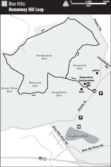
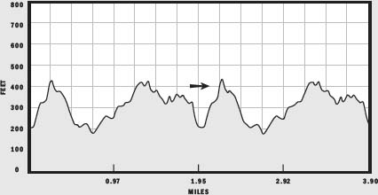
LENGTH: 3.9 miles
CONFIGURATION: Loop
DIFFICULTY: Moderate
SCENERY: Woods, ponds, streams, wetlands, and hills
EXPOSURE: Mostly shaded
TRAFFIC: Peaceful, though popular with horseback riders, mountain bikers, runners, cross-country skiers, and leisurely hikers
TRAIL SURFACE: Soil and stone, rough in places from erosion
HIKING TIME: 1.5 hours
SEASON: Year-round sunrise–8 p.m.
ACCESS: Free
MAPS: $2 at the Blue Hills Reservation Ranger Station near the trailhead
FACILITIES: Restrooms located at the ranger station.
SPECIAL COMMENTS: Trail may be wet in the spring and any time after heavy precipitation
WHEELCHAIR TRAVERSABLE: No
DRIVING DISTANCE FROM BOSTON COMMON: 9 miles
Blue Hills: Hemenway Hill Loop
UTM Zone (WGS84) 19T
Easting: 327278
Northing: 4675709
Latitude: N 40° 12' 52"
Longitude: W 71° 05' 33"
Directions
From the junction of I-93 south and US 1 south, travel 11.4 miles on I-93 to the Ponkapoag Trail, Exit 3. Drive 0.1 mile toward Houghton’s Pond. Turn right onto Blue Hill River Road and drive 0.4 miles, then turn right onto Hillside Street. Continue 0.7 miles until you see the sign for the Blue Hills Reservation Headquarters. Parking is available on the other side of Hillside Street facing a gray barn. The trailhead is at the top of the drive beside the reservation’s headquarters.
IN BRIEF
Located just outside Boston’s southern border, the vast 7,000-acre Blue Hills Reservation offers a glimpse of the past and a sense of the land before the birth of Boston.
DESCRIPTION
The Blue Hills Reservation exists thanks in large part to landscape architect Charles Eliot, who campaigned hard for its creation in the late 1800s. A progressive visionary, Eliot knew that, “for crowded populations to live in health and happiness, they must have space for air, for light, for exercise, for rest, and for the enjoyment of that peaceful beauty of nature.”
A refuge for deer, birds, amphibians, and a few footloose coyotes well versed in urban living, the Blue Hills—quite literally a stone’s throw from Mattapan’s hair-braiding parlors and ethnic eateries—is a soothing green ripple in time and place. Its woods of hemlock, beech, and oak spreading over hills of granite quiet the far-reaching sounds of the city and subdue them with birdsong and trickling streams. Old stone walls, like gray lines of slowed motion, divide the trees, casting the last shadows of Milton’s farms.
Before beginning the hike, or on your return, stop to say hello to the equine members of the Boston police force turned out in paddocks behind the barn. Start the hike where the drive meets the woods just above the barn to the left of the office. Before long the broad gravel trail picks up with a stream and a boggy basin to its left. When the climb eases, this trail joins another marked by a yellow triangle. Take this trail, bearing off to the right. From here, follow the yellow markers for the rest of the hike.
The trail cleaves through the hill as it climbs. Red squirrels hustling acorns or fending off brothers and foes squabble amid the leaves. At the top of the rise, the trail surface smooths and the hiking becomes easier. Here, the Skyline Trail, marked by blue signs, crosses the path. Catch your breath as you walk past crags of granite humbled by moss and tenacious pine saplings rooted in their crevices. On an exposed face of this hill, blueberry bushes abound, providing many pies worth of berries from late July through August to those intrepid enough to find them.
Soon, the trail begins to descend. Though easy on the legs, here again the feet are kept busy by uneven ground. A short causeway elevates you above a stream before the trail dips and turns downhill once more. On this descent, you’ll pass trails to the left and right. At the foot of the hill, turn left and walk eastward.
You might hear the whoosh of cars passing on the road a short way off, but as you catch your rhythm again on the level ground, your attention is likely to turn to deer footprints or forest delicacies like hen of the wood (Grifola frondosa) mushrooms.
On this stretch, the trail undulates gently through the woods keeping a straight trajectory. You will notice an assortment of oak species, pine, sassafras, mockernut hickory, and a few birch and beech. Only the occasional tree appears to be more than 25 to 50 years old. The generation of trees preceding these served as timber for fencing, boat hulls, and houses.
Walking on, you’ll encounter a slight downhill. A short way ahead, you come to another intersection, where an opening in the trees reveals a stream spilling into pools.
After crossing the stream, the trail meets a path leading from the road. Bear left, staying on the yellow trail. Vernal pools providing sanctuary to salamanders and hunting grounds for raccoons lie to the right, with hemlock-filled upland to the left. At the next junction, look for a sign for trail 1135 as well as a marker for the green trail. The yellow and green trails join and become one. Looking to the right, you can see a stone wall meandering through the woods on a parallel course
Hemlocks cast dark shadows along the trail, shielding a sleeping great horned owl or two. An interlacing of well-fed streams trickles through this area most seasons. A wetland with springs feeding several small ponds supports an assortment of frog species. In the spring, the chirping of the peepers raises quite a racket, sounding like something between swirling ball bearings and the chilling soundtrack of a Hitchcock film.

As the trail continues, look to the right to see a red barn on private property abutting the Blue Hills Reservation. Behind the barn, a small meadow spreads to meet the woods beside the yellow trail. Though once common, fields such as this are now scarce and more vital than ever to bobolinks, bluebirds, and swallows.
You soon arrive at a point where the trail runs into a gravel road. Turning right here, markers confirm that the yellow trail and the green trail are still joined, even as they follow this road. Keep an eye out on the left for the point at which the yellow and the green trails turn back into the woods. The trail veers left sharply, climbing into upland. At the fork, bear left. A small hill stretches your legs as the trail winds upward. Chicken of the woods mushrooms (Laetiporus sulphureus) have been found in this general spot on ailing hardwood trees.
Keeping your eyes on the trail, you may see turkey footprints among the ubiquitous deer tracks. Turkeys have become common again in the region, and wherever there is an abundance of acorns, there is likely to be evidence of these magnificent birds.
After leveling, the trail descends again and arrives at a picturesque pond. A perfect kettle hole collared by a granite-studded ridge, this pond serves as a reminder of the glacial erosion that shaped the landscape in another age.
A trail cuts back into the woods on the pond’s left. The yellow trail, however, continues along the near side of the pond, heading right. The trail jogs up an incline then quickly back down a gravelly pitch. Through a thicket to the left, you can just make out another pond that all but roars with bullfrog song in the summer.
A sign for the blue trail marks the yellow trail’s departure to the right up a steep rocky slope. On the yellow trail, wetlands hug one side while, on the other, the land drops into a deep basin. The trail bends left away from a trail heading right. At the intersection with a trail marked “1120,” markers indicate that the green and the yellow trails are still conjoined. Head uphill again to an opening where the green and the yellow trails meet the same gravel road you initially set out on.
Resume hiking on the gravel road, walking downhill. This, the final section, leads back to the trailhead. For more information about the Blue Hills, pay a visit to the reservation’s headquarters, housed in the gray-shingled house on the hill to the right. A bulletin board on the porch outside presents a calendar of upcoming events, trail condition updates, and nature news. Visitors are invited to help themselves to maps for a contribution of $2.
NEARBY ATTRACTIONS
Farther down Hillside Street on the left is Houghton’s Pond. This recreation area offers swimming, fishing, and picnicking. Restrooms, picnic tables, and barbecue grills are provided free to the public. Also close by is the Trailside Museum, the Blue Hills Ski Area, and the Blue Hills Observatory and Science Center.