38 WHITNEY AND THAYER WOODS HIKE (with Wompatuck State Park)
KEY AT-A-GLANCE INFORMATION
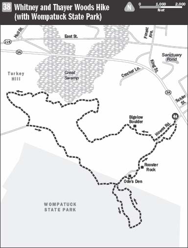
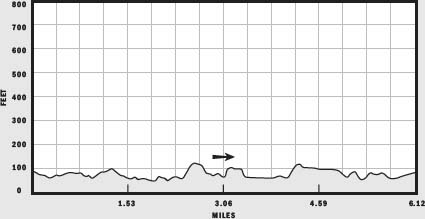
LENGTH: 6.12 miles
CONFIGURATION: Loop
DIFFICULTY: Easy to moderate
SCENERY: Woods, ponds, vernal pools, enormous glacial erratics, and garden with reflecting pool
EXPOSURE: Mostly shaded
TRAFFIC: Light to moderate
TRAIL SURFACE: Packed earth
HIKING TIME: 2.5–3 hours
SEASON: Year-round sunrise–sunset
ACCESS: Admission is free, but the trustees welcome donations.
MAPS: Available at a kiosk near trailhead and at www.thetrustees.org
FACILITIES: None
SPECIAL COMMENTS: The Whitney and Thayer Woods property combined with Trustees of Reservations–owned Turkey Hill and Wier River Farm covers 824 acres. Wompatuck State Park, another neighbor of the Whitney and Thayer Woods, adds another 3,500 acres. In addition, Wompatuck offers 262 campsites.
WHEELCHAIR TRAVERSABLE: The many carriage roads that weave through this property are traversable by wheelchair; however, several paths included in this hike are not.
DRIVING DISTANCE FROM BOSTON COMMON: 13 miles
Whitney and Thayer Woods Hike
UTM Zone (WGS84) 19T
Easting: 349479
Northing: 4677415
Latitude: N 42° 14' 04"
Longitude: W 70° 49' 27"
Directions
From Boston, take I-93 to MA 3 (Cape Cod). From MA 3, take Exit 14 to MA 228 north. Continue 6.5 miles through Hingham. Turn right onto MA 3A east and follow it 2 miles to the entrance and the parking lot on the right.
IN BRIEF
Hiking miles of groomed carriage roads and rugged footpaths through hemlock and holly groves, visitors will take in such spectacles as a magnificent woodland garden and a glacier-made granite rooster.
DESCRIPTION
From the parking lot, set out hiking southwest on Howe’s Road, the carriage path located at the head of the lot. Serpentining down a gentle grade, this road cuts an elegant route through woods, passing vernal pools on either side. After a few long, leg-loosening strides, the world outside, with its gas stations and convenience stores, fades as another replaces it—a place created by Wampanoags, early settlers struggling for a foothold, a handful of well-heeled folks, a down-and-outer or two, and the U.S. government.
The dense woods have grown in since New England’s agriculture went bust at the end of the 19th century. A hiker here—say, in 1815—would have found barely a tree in sight. By then, woolly-backed sheep and stiff-gated goats had replaced the hardwoods and conifers that had previously sheltered grouse, deer, and other game coveted by Native Americans.
An unmarked trail or two diverts left and right, but stay with Howe’s Road until it reaches a junction marked “2.” Here, turn right to leave the manicured carriage road for a less-tamed footpath traveling westward over roots and granite rubble between two stone walls, one edging wetland, the other tracing a line across upland.
Ahead, the enormous boulder looking as odd as a goose egg laid on a frozen lake, is Bigelow Boulder, named after Reverend E. Victor Bigelow, the author of the first volume of the Narrative History of Cohasset. It was Henry M. Whitney, the owner of much of these 824 acres in the first half of the 20th century, who reshaped the stagnating farmland into a grand estate. A lover of horses and equestrian sport, Whitney had the bridle paths cut and carriage roads laid out and carved to enable him and his guests to enjoy his land and its natural wonders from the saddle or the seat of a smart buggy. As president of the West End Street Railway, Whitney presided over the development of the Boston rail system that is now known as the MBTA.
In 1889 Whitney’s enterprise employed 9,000 draft horses and was growing by leaps and bounds, so much so that Boston’s four-legged population seemed to be outpacing that of humans. But Whitney jumped aboard the technological wave and converted the light-rail to electrical power. Almost overnight, the horses were retired from streetcar duty. Faced with so many jobless equines, Whitney may have reassigned a flashy chestnut or two to the Bigelow Boulder route.
Bigelow Boulder sits at junction 3, where the footpath crosses Boulder Lane. To continue, pass to the left of the granite monolith, staying with the footpath as it travels northwest back into woods. Small white squares mark the way. Heading downhill at first, the path winds through young beeches and pines, passing an occasional spindly holly. Now and again it parts one of the many stone walls built after 1670, when the surveyor Joshua Fisher cleaved the land into mile-long 25-foot-wide strips to facilitate land trading among Cohasset’s first settlers.
After crossing wetland via a sturdy 20- to 30-foot-long boardwalk, the trail bows south at a stream and rambles back uphill. Rocks with fleshy lichen ears loiter off to the side as if listening for gossip.
Breaching from the woods at junction 6, the trail continues across Boulder Lane. For the sake of variation, bear right and hike west on the carriage road.
Following a downward slope to a swampy brook, the route winds its way back uphill to meet Whitney Road. For a shortened loop, hike left; otherwise, continue northwest on this road packed hard by clopping hooves (and the trustees’ maintenance personnel) and colored orange by a steady rain of pine needles.
At junction 8, leave the predictable footing of the carriage road for the root, rock, and water hazards of a wooded path to the right. Starting off with a steep but brief climb, the trail reaches a pinnacle then zigzags erratically on a northeastern course, mostly downhill, to a well sitting in a clearing.
At marker 12, the trail crosses Adelade Road, which stretches east toward Scituate Hill. Beyond this intersection the trail arcs westward, shedding hardwoods and hollies for hemlocks as it touches the outer reaches of Great Swamp. The area is gorgeous in winter—when snow sparkles on lowhanging hemlock boughs, and in spring—when fists of skunk cabbage push through the last of the frost, and red-winged blackbirds wake the place with their raspy song and the shock of red against black. And the scene is stunning in fall—when maples and birch give up their green for riotous reds and cracking yellows. But for sinister mosquitoes, gnats, and deer flies, the swamp’s loveliness peaks in summer when with their incessant buzzing and biting, they mask the beauty for all other beings. Arriving at the footpath’s end at marker 13, hikers happy to be back on flat ground can continue to the right, on Turkey Hill Lane. But for a more adventurous trek, cross the carriage road and resume the footpath that leads back uphill into woods. Climbing the heap of glacial debris, the path shimmies past a boulder—crumbling like a last piece of layer cake sitting among crumbs—to reach an overlook at junction 14. After surveying the view and maybe settling in for a picnic, continue westward on the path to the right.
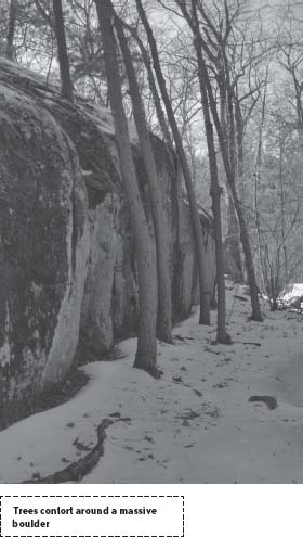
Follow white markers as the trail slopes back down to level ground and bears right at a broad, vaguely marked junction. Around a bend, the trail crosses a glade walled in by a great wedge of rock greened by ferns and moss. Lithe trees growing close to the mass bend from it like waves peeling away from an ocean liner.
Twisting its way north, the trail soon crosses paths with an abandoned railroad track that is being converted into a hiking trail. As of this writing, the project is nearing completion. In any case, stay with the footpath as it bisects the former rail line and continues into the American holly grove opposite.
Aiming west toward Turkey Hill, the trail continues to follow white markers. After winding through muddy lowland often imprinted with deer hoofprints, the trail gradually steepens as it gains traction beneath red pines on the eastern slope of Turkey Hill. Ahead, where the plane levels and the trees thin out, the trail meets One Way Lane.
At this junction (16), bear left and follow the cart road southeast down a gentle grade. The gangly woods, made up of early successional species, hints that this hilltop offered an open vista in the last century. Meadowlarks (Sturnella magna) and bobolinks (Dolichonyx oryzivorus) flitted about the hay fields then; today, pine siskins (Carduelis pinus) singing in the upper stories add variation to the throaty chirps of chickadees.
Reaching James Hill Lane at junction 17, hike left to descend to a glacier-scoured valley cradling the defunct rail line. Follow the lane across the valley and up and over the lofty drumlin beyond. At junction 18, at the base of the hill, steer right to leave the carriage lanes for the Milliken Memorial Path, a path Arthur Milliken cleared and made magnificent with densely planted azaleas, rhododendrons, mountain laurels, and other showy shrubs to honor his wife, Mabel Minott Milliken, who died in 1927.
After tunneling through an herbaceous corridor, the path spreads wide as it bridges wetland and ascends to another evocative boulder—this one looking like a loaf of bread with a slice tilting off the end. Behind it are more glacial erratics, clustered together in a picturesque spot equipped with a bench.
Farther southeast is a sculpted pool nested between the path and a curtain of granite embellished with velvety moss and extravagant fern fronds. It’s futile to try to hurry through. Adopt “island time” and spend a moment or two drinking in the beauty from the well-hidden bench to the left of the pool.
Traveling between Brass Kettle Brook and the edge of upland, the path soon arrives at its end, at junction 19. Here Howes Road, bearing left, offers a neat link back to the parking lot. To add a circular jaunt through Wompatuck State Park’s nature study area, bear right.
In 1941 when World War II was intensifying, wishing to build a naval ammunition depot, the U.S. government took a third of the Trustees’ Whitney Woods property, including these acres, by eminent domain. Twenty-five years later, in more-secure times, the government released the land, and the acreage was joined with that of Wompatuck.
The trail leads up a gravely slope, past a marker that reads NS7 to a map kiosk inside the state park’s border. From this post, follow the hardscrabble trail to placid hemlock woods above. Stay left at marker NS6 to continue south to junction NS5. Here, the path to the right leads to Doane Street, the former property line of Whitney Woods.
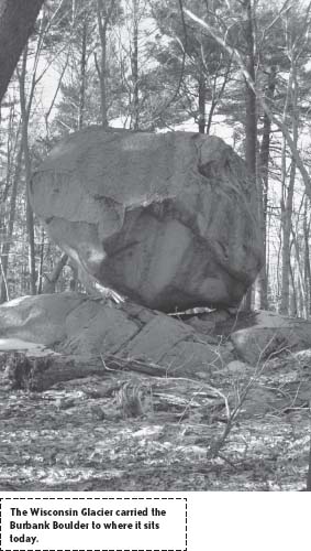
Turn left and left again at each junction that follows, to complete the loop begun at the kiosk. Mounded and soft, the wooded landscape resembles a hastily made bed. Though disturbed by natural forces and axes many times, it is now remarkably quiet. About midway along this stretch, the trail passes the Burbank Boulder, another glacier-age vagrant biding its time.
Upon reaching the kiosk, reenter the Whitney and Thayer Reservation and take up Howes Road at junction 19. Elevated to evade seasonal flooding, the carriage road crosses Brass Kettle Brook, then taking a northeast tack, meets Bancroft Trail at junction 20. To visit two more points of interest, switch tracks and bear right. A handful of twists and turns away, the path reaches a castlelike rock cave. Made homeless in 1830, Theodore “Ode” Pritchard found the shelter to his liking and moved in. The accommodations were temporary, but the name “Ode’s Den” stuck for good.
White markers lead right into and through Ode’s grandly humble abode, heading through a rock garden rendered by clumsy fingers of ice. Every now and again amid the topographical chaos, a stone wall marches by.
As the trail swings northwest on the edge of a valley, it passes a massive rock configuration painted with the letter “R” to identify it as Rooster Rock. Catch it at the right angle in the right light, and it is the spitting image of a rooster sporting a fancy comb.
A few yards farther, the trail reconvenes with Howes Road at junction 21. Bear right to proceed northeast. Arriving at an orange chain gateway moments beyond junction 22, rather than ending, the route continues past a private home. Talk softly to the barking dog tied outside and continue on to junction 2. Here, leave the carriage road once more and hike the Bancroft Trail back to the parking lot.
NEARBY ATTRACTIONS
Seventy-five acre Weir River Farm, owned and managed by the Trustees of Reservations, boasts hay fields, managed woodlands, a stable and barn, and, best of all, friendly livestock. Access the farm via MA 228 in Hingham. From MA 228, turn right onto Levitt Street, continue 0.6 miles, and bear left onto Turkey Hill Lane. Follow it to the end.