39 DESTRUCTION BROOK HIKE
KEY AT-A-GLANCE INFORMATION
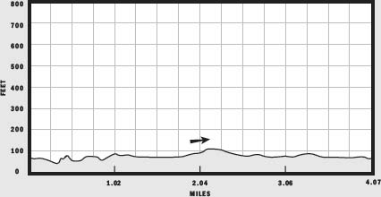
LENGTH: 4.07 miles
CONFIGURATION: Two linked loops
DIFFICULTY: Easy
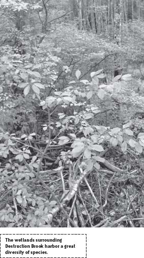
SCENERY: Millworks first built in 1690; holly woods and abandoned farm established in 1853, American beech and Atlantic white cedar
EXPOSURE: Mostly shade
TRAFFIC: Light to moderate
TRAIL SURFACE: Packed earth
HIKING TIME: 2.5–3 hours
SEASON: Year-round sunrise–sunset
ACCESS: Free
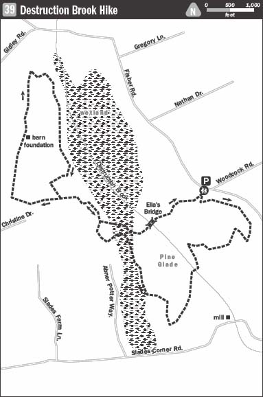
MAPS: Available at kiosk by the trailhead and online at www.dnrt.org/pdfs/dbwmap1.jpg
FACILITIES: None
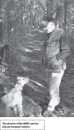
SPECIAL COMMENTS: Destruction Brook is one of 40 reservations of the Dartmouth Natural Resources Trust, which, to date, has helped preserve 4,000 acres.
WHEELCHAIR TRAVERSABLE: The red and yellow trails both offer access to wheelchair users.
DRIVING DISTANCE FROM BOSTON COMMON: 59 miles
Destruction Brook Hike
UTM Zone (WGS84) 19T
Easting: 331956
Northing: 4605110
Latitude: N 41° 34' 48"
Longitude: W 71° 00' 57"
Directions
From Boston, take I-93 south 12 miles, then take Exit 4 on the left to merge onto MA 24 south toward Brockton. Drive 38.1 miles to Exit 4 to merge left onto I-95 east toward New Bedford. Continue 4.6 miles and take Exit 11 toward US 6/Dartmouth to merge onto Reed Road. Take Reed Road 2 miles and turn left onto Beeden Road. Continue 0.7 miles and turn right onto Old County Road. After 0.1 mile, turn left onto Fisher Road. Look for a wooden Dartmouth Natural Resource Trust sign for Destruction Brook Woods on the right. Park just off Fisher Road, adjacent to the sign.
IN BRIEF
Located upstream from Dartmouth’s historic Russell Mills, this hike takes you on a tour of land preserved much as it was in the 1600s when the area was first settled.
DESCRIPTION
From the off-street parking, head southwest on the broad trail marked by the Dartmouth Natural Resource Trust (DNRT) sign. A hundred yards or so in from the road, the trail leads to a kiosk displaying a map of the property and DNRT news and information. Continue from here along the yellow trail to reach a three-way intersection. At this junction, turn left to hike east along the yellow trail, paralleling Fisher Road through woodland composed of pine, oak, and maple.
Ahead where the yellow trail meets the blue trail, bear left to hike southeast behind houses on Fisher Road. Then, turning away from backyards, follow blue trail markers to the uneven terrain of a weathered esker. At the next split, bear right switching back to the yellow trail to retreat to deeper woods.
Becoming narrower as it runs under a canopy of trees, the trail dips and climbs then merges with another trail. Continue following yellow markers. At a somewhat baffling intersection follow the path to make an about-face and head north. Continue downhill off the ridge to reach another junction. Stay to the left to hike southwest on the wide yellow trail over level ground. Undulating westward the trail passes a stream and scattered birches. Bear left again at the next fork to follow the yellow trail as it swings to the south. Snaking onward through the landscape the trail soon leads to a bench on a banking overlooking Destruction Brook and remnants of the millworks first established here around 1690.
From this spot, descend the banking and turn left onto the red trail which traces the flow of the brook. Shortly, this route joins the yellow trail, and the two continue as one. Passing a gate to the left, the trail curves south and crosses a wide bridge. On the opposite bank, the trails separate; stay with the red trail and continue hiking south. Although the coast is nowhere in sight, the dead-level ground dusted with silver sand bespeaks the land’s position just a hair above waves coursing to the seashore nearby.
Ahead, the trail eases westward to pass a white house sitting among pines on the left. Just beyond this, the trail reaches another intersection. The path to the left leads to alternative parking for the reservation, and a path straight ahead leads to an open meadow. Steer away from these and stay with the red trail, bearing right. A moment later, a red arrow at knee level redirects the trail left, back on a westward course.
Here knobby American holly trees (Ilex opaca) punctuate the woods otherwise dominated by red oak and white pine. If you are hiking through in midautumn, when the female hollies are bearing berries, watch for goldfinches and cedar waxwings. Ahead, the land to the left dips to a valley, while on the right it remains even with the trail, which now eases northward. At the next two forks, stay to the left on what remains of the red trail, which is scarcely marked through here.
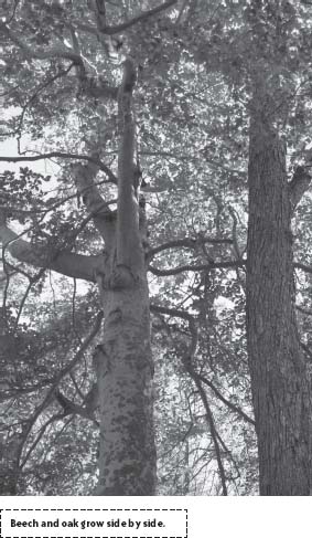
Dipping beside wetland on the left, the trail swings on several points of the compass but continues generally northward. Holly trees grow more thickly along this avenue, mixing with maples, beech, and omnipresent oak and pine. At one point, the trail passes a magnificent beech tree growing flush to an equally magnificent oak. Equivalent in height and girth, they make an odd pair.
Weaving through wetland, the red trail eventually aims northwest to meet the green trail. This junction is marked both with the letter “D” on a stone and a sign that reads “Start of Green Loop.” Leave the pine-thick red trail here and continue northwest down a slight grade on the green trail. Thick woods and a stone wall lie to the right.
A few hundred yards ahead, where the trail forms a “T,” turn left and continue west toward a house neighboring private property. Where the trail forks a few feet farther on, bear right to hike north tracking a stone wall built back in the mid-1800s, when a farm was established on the 90 acres encircled by the green loop.
Along this section of former cart road, boughs of giant hickory trees arch overhead. Bittersweet clings to many of the trees like cobwebs on the furnishings of a deserted mansion. Though nearly retaken by nature, the place has not yet fully given up its former self. Like mud-caked draft animals eager for work, the root-jostled wall and ancient fruit trees humbled by sucker growth and competition from pines appear to long for the return of their master. It’s been many years since this land was a working farm, but the spirits of those who shaped this place hold on. Midway down the path on the right is a foundation for what was once a great barn. All but the deep rows of stone it sat upon are gone.
Beyond the barnyard, the path leads across a stream that feeds into wetland to the east. Take a moment here to notice how the stone wall paralleling the path was artfully engineered to bridge the flowing water.
A short distance farther, the path reaches a point where the DNRT reservation ends. The land beyond this border is also protected and open for public use. In any case, the green trail continues ahead, emerging from the woods briefly as it passes privately owned land lying to the west. Watch to the east for a path leading into a thicket of pines to an intriguing cemetery where several of those who lived on this land in its most productive days are buried.
Trust the trail as it forges northward; the way is clear though momentarily bereft of markers. Coming to the end of the avenue draped voluminously with vines, the trail arrives at a junction. “No trespassing” signs rule out the paths to the left and center, leaving two paths to the right. Of these, choose the soft right and hike southeast down a pitch. A sandpit lies ahead on the left and, in it, the carcass of a sedan pinned between two pine saplings. As if spooked, the trail cuts sharply away from this wreck and runs into woods of cedar and holly.
Looping around the eastern side of the wetland, the trail splits briefly upon reaching an esker. For the sake of the view, bear left to ascend the 30- to 50-foot skeletal mound of glacial debris. A century ago, cows lulled in a pasture below; today little stirs but red squirrels and crows.
As the esker subsides, the land on the right falls away to a deep glade. Having the hushed feel of a room just made empty by a crowd, this natural basin held grazing cows. Scrappy trees have grown in over time, but none look as though they will ever achieve the height and girth of the tremendous oak that stands at the center. Known as the Pasture Oak, this tree may have been rooted here since King Philip’s father, Massasoit, sold this territory to Pilgrim colonists intent on moving beyond Plymouth. If not, it was certainly here in 1773 when colonists disguised as Mohawks heaved 342 chests of tea into Boston Harbor from the Dartmouth, a ship built by Joseph Rotch, a native of these parts.
From this old meadow, the barely marked green trail continues southeast through swales and over bumps until, bending westward, it returns to the start of the loop. To complete the hike, return to the junction where the green and red trails meet and bear left onto the red trail, heading east. Running wide and flat through wetland thick with maples, this trail is easy to follow. Plentiful red markers guide the way to Ella’s Bridge lying just ahead at Destruction Brook.
Upon crossing to the opposite bank, quit the red trail and pick up the yellow trail once more, and continue straight ahead. Weaving through woods draped with curtains of bittersweet, the trail soon reaches a vibrant pine grove. Look for where the trail splits left to return to the start at Fisher Road.
NEARBY ATTRACTIONS
Another place worth visiting in this spectacular part of Massachusetts is the Lloyd Center for the Environment. Offering 5 walking trails over 55 acres of oak-hickory forest, freshwater wetlands, estuary and salt marsh, the center also has an observation deck named one of 15 “special places” in the Commonwealth of Massachusetts. The Lloyd Center for the Environment is located at 430 Potomska Road, Dartmouth; (508) 990-0505. From the Destruction Brook Reservation, drive southeast on Fisher Road 4.3 miles. Turn right onto Russell Mills Road, then turn left onto Rock O’ Dundee Road. Turn right onto Potomska Road and continue 1.2 miles to the Lloyd Center.