47 ROCKY NARROWS LOOP
KEY AT-A-GLANCE INFORMATION
LENGTH: 3.8 miles
CONFIGURATION: Loop
DIFFICULTY: Easy to moderate
SCENERY: Views of the Charles River, forested wetlands
EXPOSURE: Mostly shaded
TRAFFIC: Light
TRAIL SURFACE: Packed earth, rocky in places
HIKING TIME: 2 hours
SEASON: Open year-round sunrise–sunset
ACCESS: Free
MAPS: Available at www.thetrustees.org
FACILITIES: None
SPECIAL COMMENTS: Rocky narrows is a gateway to the Charles River and the Bay Circuit Trail—a 200-mile continuous greenway around Boston from Kingston Bay on the south shore to Plum Island.
WHEELCHAIR TRAVERSABLE: No
DRIVING DISTANCE FROM BOSTON COMMON: 19 miles
Rocky Narrows Loop
UTM Zone (WGS84) 19T
Easting: 305745
Northing: 4677547
Latitude: N 42° 13' 33"
Longitude: W 71° 21' 14"
Directions
From Boston take I-90 west 16.9 miles. Take Exit 13 to MA 30 east. Turn Right onto Speen Street then continue 2.8 miles and turn left onto Coolidge Street. After 1.2 miles turn right onto north Main Street. Continue 2 miles and turn left onto Goulding Street. At 0.6 miles turn left onto Forest Street; parking is on the right.

IN BRIEF
In this hike you will see the Charles River at its finest. Starting off from a field kept clear since farming days, the trail leads through reforested agricultural land to a canoe landing then tracks the river.
DESCRIPTION
In 1897, five years after landscape architect Charles Eliot founded the Trustees of Reservations, Frederick Law Olmsted Jr. Oversaw the initial transaction that was to lead to the protection of 227 acres on the Charles River in Sherborn, property now called Rocky Narrows. Although still largely farmland producing dairy goods and cranberries for local consumers, and vast quantities of “Champagne” cider that was shipped as far afield as Texas, Nebraska, England, and Belgium, Sherborn was changing fast as the turn of the century approached. Keen on preserving the land, Augustus P. Hemenway provided the funds to purchase the first 21-acre parcel of Rocky Narrows. In the years since, others have made similar donations, with the most-recent acreage added in 1995.
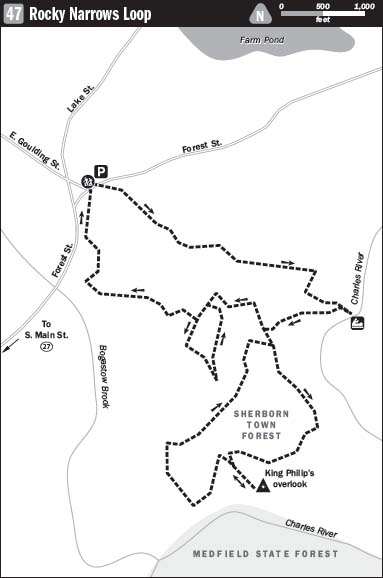
Begin your hike by picking up the slender path that starts to the left of the Forest Street parking area at the head of a meadow. Crossing the grassy expanse to join a gravel road, bear right where the road forms a V with a rutted wagon route and continue southeast past an oak on the left and a cedar tree standing beside a stone wall opposite. From here you will notice red dots marking the way. As you hike along this open stretch songbirds will likely distract you with their song or audacity as they fearlessly fling themselves at passing hawks.

Guided by stone walls on either side, the path quickly heads into woods composed of white pine, oak, cherry, and nut trees that have grown in since Eliot and Olmsted took protective charge of the land. The walking is easy as the broad path winds down around soft bends, making a causeway as it passes through wetland. In early spring, before deerfly season, bunches of green skunk cabbage brighten the bog. Later in the season, you will see plenty of butterflies and maybe even the rare lady’s slipper orchid.
When the path arrives at a split with the number 21 posted on the right, continue to the left, walking eastward. The dominant species of tree shifts to pine as the trail leads to a clearing at a “T.” From here, turn right (south), noticing marker number 20. Follow as the trail tacks southwest, passing beneath tall conifers through a distinctly wetter zone. Soon you arrive at another fork. At this juncture, bear left onto the red trail.
The massive pines and hemlocks along this part spread a beautiful canopy overhead. Though old-growth trees were mostly cleared for pasture in New England, a few stands still exist in some areas, such as in this riparian zone. In a moment, you arrive at a clearing where the woods end at the sandy bank of the Charles River. The number 19 on a tree identifies this spot as the canoe landing at Rocky Narrows. It would be hard to resist a dip on a steamy day in July, despite the possible presence of leaches (a good reason to bring salt along). A decade or two of concerted efforts to clean up the Charles River has seen impressive results. Fish are jumping again, muskrats are back in strong force, and there have been claims of otter sightings.
Leave the canoe landing, heading southwest along the river’s edge. Tufted titmouse and warblers up from the tropics for the summer sing in underbrush growing between the woods and the water. Eventually the trail turns away from the river and joins a path going off to the right. Keep left and travel west up a hill. You will see the number 18 and a red dot on a tree to the left. Follow these as they direct you up a steep embankment and lead you along a hemlock-sheltered ridge high above the river. Continuing along the ridge you will pass a trail coming in from the right. A little farther on, you meet with another trail; keep to the right here, leaving the ridge to head west following the red marker.
The path widens, levels, and soon arrives at a triangular intersection marked 16. Walk straight through, staying with the red trail. Elevated above the river basin, the path is surrounded by young woods. Glimpsing the horizon, you see nothing but seemingly untouched land for miles. Follow the path downhill until you come to trail 14. Take this sharp left-hand turn back uphill to reach King Philip’s Overlook.
Standing atop this granite cliff, looking across the rich valley empty of any buildings, modern or otherwise, it is easy to put oneself in the mind-set of Metacomet (given the Christian name “Philip” by his father Massasoit), the leader of the Pokanoket tribe of Wampanoag. Disturbed to see his people being killed off by disease brought by these land-hungry foreigners, King Philip (as he was nicknamed by the British) launched an all-out war against the white New Englanders in 1675.
Leaving the overlook, double back to return to the red trail, taking it downhill toward railroad tracks. The trail curves right as it nears the tracks then descends another long slope. Farther on when the trail splits at marker 12, break off to the right and climb back east before arriving at another intersection and continuing northward. In short time you will arrive at another junction, marked 26. Cross here, hiking northeast.
Partway down a rocky slope edged with pine saplings, you will come to a trail running uphill off to the right. Climb this link to where it connects with the red trail. Hike to the left, back to marker 18 then follow the red trail to where it cleaves through a stone wall. Here turn left onto a narrower trail.
When you reach a four-way intersection, turn right (northwest) and follow the path straight to marker 24 and continue on. Here, bear left to head southwest. You will pass one or two sketchy trails diverting to the left but stay on course to reach marker 25. At this intersection follow the trail left as it climbs a hill through a dense growth of young white pines. Reaching another junction, continue left and travel slightly downhill, heading northeast. Passing the green trail, continue straight ahead to reach another fork. Stay to the left here and head left again at the next split. At the next intersection, turn right onto a path running along a stone wall.

This path, marked with orange, treads between wetlands and upland to reach marker 10. From this junction head northwest on the red trail, continuing to the left at the next fork. A short way farther on, turn right to return to the Red trail. Having zigzagged your way to marker 8, the last crossroads of the hike, bear left to link back to the parking lot.
NEARBY ATTRACTIONS
After a hike at Rocky Narrows, animal lovers, peaceniks, and anyone else needing an excuse to spend an extra hour or two in beautiful Sherborn might like to stop in at The Peace Abbey Multifaith Retreat Center located at 2 North Main Street. A multifaith chapel, pacifist living-history museum, vegan-peace sanctuary, and guest house are just a sampling of what you will find at the center. But of all the center’s offerings it is the Sacred Cow Animal Rights Memorial that will most likely stir your heart—perhaps even inspire you to vegetarianism. The memorial features a life-size bronze statue of “Emily the Peace Cow” who lived at the center for 8 years after escaping a slaughterhouse by leaping over a five-foot fence and evading capture by hiding out in nearby woods with a herd of deer for 40 days and 40 nights. Hours are Monday through Friday, 9 a.m. to 5 p.m., Saturday and Sunday, 10 a.m. to 6 p.m. Phone (508) 655-2143.