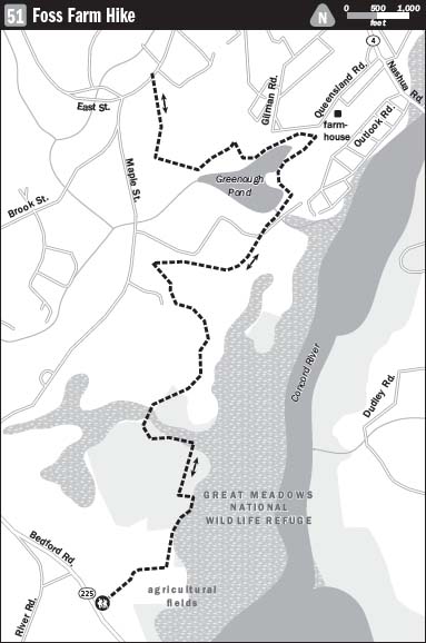
51 FOSS FARM HIKE
KEY AT-A-GLANCE INFORMATION
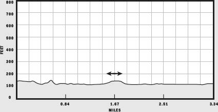
LENGTH: 6.7 miles
CONFIGURATION: Out-and-back
DIFFICULTY: Moderate
SCENERY: Fields, woods, and riverine wetlands
EXPOSURE: Mostly shaded
TRAFFIC: Light
TRAIL SURFACE: Grass, packed earth, and boardwalks
HIKING TIME: 3 hours
SEASON: Year-round sunrise–sunset
ACCESS: Free
MAPS: Posted at the entrance
FACILITIES: None
SPECIAL COMMENTS: Waterproof shoes are recommended in wet months.
WHEELCHAIR TRAVERSABLE: No
DRIVING DISTANCE TO BOSTON COMMON: 27 miles
Foss Farm Hike
UTM Zone (WGS84) 19T
Easting: 309544
Northing: 4709342
Latitude: N 42° 30' 47"
Longitude: W 71° 19' 07"
Directions
From Boston, take Interstate 90 west 9.4 miles to I-95 north. Continue 9.4 miles to Exit 31B/MA 4 north toward Bedford. Travel 2.8 miles; turn left onto MA 225 and continue 4.1 miles. Shortly after crossing the Concord River, look for a dirt road on the right leading to a dirt parking lot. There’s a sign saying “Foss Farm” on the roadside, but it is not easy to see.
IN BRIEF
This hike shadows the Concord River, staying clear of its floodwaters and biting insects. Crossing through conserved farmland and a magnificent tract called The Great Meadow owned by the National Wildlife Federation, the trail passes through woods and picturesque farmsteads before rounding a large pond teeming with lily pads then doubling back to Foss Farm.
DESCRIPTION
Upon finding the trailhead at the edge of the parking lot, set out heading northeast across an open field. Rising and falling with the curve of the land, the path soon leads to two horseback-riding rings, one straight ahead and another around a corner to the left. Foss Farm is a popular destination for local equestrians who come to school their horses and to compete in horse shows held here in summer and autumn. On the fresh June day that I passed through, Amanda Brem and her Appaloosa, Lucy, flashed by at a canter.
Follow the path north past the riding ring, along the edge of a hay field planted with timothy. Reaching woods, the path turns right and heads toward gardens in the northwest corner of the field. Watch for swallows swooping low over the open grassland, and while swatting mosquitoes, consider that each of these aeronautic whizzes eats fours times its body weight in insects every day. Besides swallows, you are also likely to see eastern bluebirds darting by.
At the northwest corner of the field, you will find a sign marking a trail leading into the woods to the left. Turn here to leave Foss Farm and enter land owned by the National Wildlife Federation. A few feet beyond a gap in a stone wall, the path reaches an intersection. The River Trail lies to the right and the Redtail Trail to the left. Flooding forced my choice of route since tremendously heavy spring rains had the River Trail’s extensive boardwalk fully submerged. Chased by a cloud of newly hatched mosquitoes, I quickly rethought my plan. Teflon hides are needed for hiking the River Trail in spring and summer.
Heading north on the Redtail Trail over level ground ever so slightly out of reach of floodwater, you pass through a grove of red pines dense enough to suppress growth of any underbrush save ferns that thrive in wet, dimly lit conditions. Woodcocks also favor these parts, both for the cover they provide and for the earthworms that multiply voluminously in the forest detritus.
Weaving this way and that, the trail eventually leads to a watery mire linked to a small pond formed with the help of a dam put in place by farmers in days gone by. Here a sturdy wooden boardwalk and footbridge facilitate passage. Judging from have-a-heart-style trap submerged near the dam, the impressive depth of the floodwater is attributable in part to beaver engineering.
After crossing the bridge, bear right to continue northeast, making your way along a path that skirts the expansive Great Meadows Wildlife area. Because mowing is frequently inhibited by wet conditions, lush grasses are inclined to overwhelm the trail here. In June the humid air is filled with the ecstatic pulsing chirps of frog song. Given the wet, rich herbaceous growth, and the amphibian chorus, the setting feels more like Mississippi than New England. Farther along the tended side of the field transitions to grassland left to revert to its natural state. Though the area is open and dominated by grasses and wildflowers, aspen, birch, and pine saplings are beginning to assert themselves.
Leaving the Great Meadows, continue west along a mowed pathway through another field. Near a sign simply marked “Trail,” the path splits in two. Take the trail to the left to promptly arrive at another intersection. Here, signs point back to Foss Farm and to the Pine Loop. Leave the meadows behind and continue to the left, heading west under the cover of pencil-straight pines. Traveling through this cultivated evergreen grove, the path curves northeast. Shortly you come upon a sign pointing to Maple Street, a pond, and the river to the right. Turn off here to continue northward. Still surrounded by lofty pines, you may hear a car pass on the street barely visible to the left. Rounding the knoll, glimpse the river edging into a field on the left. Just ahead, the trail dips to another fork. Continuing straight, the Pine Loop trail leads back to Foss Farm while the path to the left quits the woods and aims for Maple Street. Choosing the latter route, head east across the field toward the river. A picturesque house and barn sit on private property to the left. Back now in the river’s floodplain, brace yourself for another foot soaking and attack by marauding mosquitoes.
After crossing the field, the path reenters a wooded corridor dense with oaks and pines. Several yards away, hidden by a tangled thicket, the Concord River flows southwest, meandering seaward. A sign ahead directs hikers to the right, away from private property. Behind, emerging from the bog, is the tantalizing River Trail. To the side of it, a droll sign advises dry-season use only. A sign bearing the universal stickman treading water or fending off giant mosquitoes would better convey the intended message.
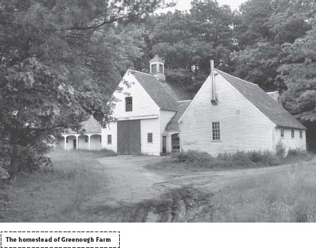
Hiking a few hundred yards more on what becomes a dirt road, you will arrive at the eastern end of Greenough Pond. A dam and ruler-straight causeway bridge the water, allowing passage from the fields of Greenough Farm to the homestead just within sight. With its last crops harvested long ago, Greenough Farm is now idle conservation land, its handsome white barn and clapboard home ghostly vacant. Follow the road to the barnyard and search to the left to find a weathered post marking where the trail continues along the pond’s bank.
Though overcome by weeds at the start, the trail becomes easy to follow as it encircles the pond. Looking through a veil of overhanging branches, you might see a wood duck paddle by or glimpse the blue streak of a diving kingfisher. Failing this, you are guaranteed to see redwing blackbirds, dragonflies, damselflies, and thousands of flowering pond lilies.
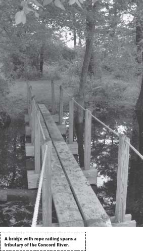
On the western side of the pond, the trail bends south and crosses a tributary by way of a wooden footbridge. Beyond the bridge, follow the trail now marked with red dots, as it climbs up a banking and bends away from the pond back into woods. After crossing another stream, the trail splits at an unmarked intersection made distinct by a telephone pole at its center. Choose the trail to the right, which widens as it climbs. Beyond a break in a stone wall a sign points to the right to parking. Undulating through woods, this broad, well-traveled path leads to a bold-yellow arrow painted on a rock soon after the trail’s end at Maple Street. From this terminus, turn and hike back to Foss Farm.